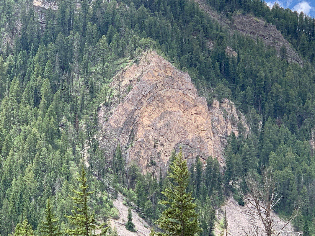
Thrust Belt Anticline (fold) in Hoback Canyon
Picture by Mark Fisher
Picture by Mark Fisher
Wow Factor (4 out of 5 stars):
Geologist Factor (4 out of 5 stars):
Attraction
A geologic and scenic delight with interesting faults and folds, peaceful Star Valley, dramatic Wyoming Range & Salt River Range and beautiful Hoback River, Snake River, and Greys River.
History of Wyoming Thrust Belt
The complex structure of the linear mountain ridges in southwest Wyoming are a portion of the central Rocky Mountain thrust belt of Wyoming, Idaho and Utah. These mountains, in turn, are part of a structural province extending from Canada to New Mexico. They are products of the Sevier Orogeny, a compressional mountain building event that was active from the late Jurassic to Eocene, 140 to 55 million years ago. This event was caused by east dipping subduction of oceanic plates along the western margin of North America. The Wyoming salient (eastward bulge in the thrust belt) extends from the Snake River Plain in Idaho to Utah and is 100 miles in length and 60 miles wide.
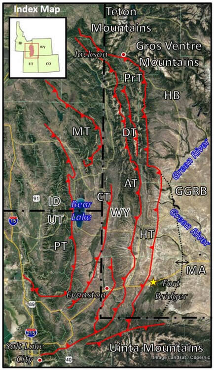
Index map of the Wyoming-Idaho-Utah thrust belt. The four major thrust systems are shown, oldest to youngest (west to east) they are the Paris-Willard, Meade-Crawford, Absaroka, and Darby-Prospect-Hogsback. Abbreviations: AT, Absaroka Thrust; CT, Crawford Thrust; DT, Darby Thrust; GGRB, Greater Green River Basin; HB, Hoback Basin; HT, Hogsback Thrust; MA, Moxa Arch; MT, Meade Thrust; PT, Paris Thrust; and PrT, Prospect Thrust.
Image: Google Earth
Image: Google Earth
Aerial view of Idaho, Wyoming thrust belt, looking north. In this picture, the thrust faults run parallel to the north-south strike of the beds.
Image: Miller, M., circa 1999, Aerial photo of thrust belt; http://marlimillerphoto.com/SrF-17.html
Image: Miller, M., circa 1999, Aerial photo of thrust belt; http://marlimillerphoto.com/SrF-17.html
The land did not become United States territory until the Mexican Cession of 1848. The early explorers and fur trappers Ashley, Sublette, Campbell, Bridger, Vasquez and Bonneville reported the geography of the thrust belt from 1834 to 1858. Emigrants passed through for gold, land and religious freedom along the established trails. The Oregon, Mormon and California Trail followed a path from Fort Bridger through the southern portion of the Wyoming-Utah thrust belt. Later, the Overland trail paralleled the route. The Army took over Fort Bridger in 1857, after the Mormons burned it at the outbreak of the Utah War (1857-1858). The Lander cutoff to Oregon was built then, separating from the main Emigrant route from South Pass and passing through the north edge of the thrust belt. Early exploration of the Thrust Belt was focused near these trails.
Evanston was established in 1868 as the Union Pacific Railroad construction neared the region in 1868. Previously a stopping point on the Overland Trail for greasing of wagon axles. It provided better access to the region and with the railroad local western headquarters (1869), Evanston became the hub for entry into the thrust belt terrane.
Evanston was established in 1868 as the Union Pacific Railroad construction neared the region in 1868. Previously a stopping point on the Overland Trail for greasing of wagon axles. It provided better access to the region and with the railroad local western headquarters (1869), Evanston became the hub for entry into the thrust belt terrane.
Geology Of Wyoming Thrust Belt
For millions of years Paleozoic and lower Mesozoic sediments were deposited in a basin along the western margin of the Wyoming craton. During latest Jurassic to Late Cretaceous, subduction along the west side of North America produced east-directed compression. Thrust slices of Proterozoic accreted blocks and Phanerozoic rocks were transported eastward on shallow west-dipping thrust faults. The Paleozoic and Mesozoic units detached on a glide plane above the Archean basement (“thin skin thrusts”). Faults formed preferentially in mechanically weak zones (shales). Smaller detachments occurred in other weak lithologies (shaly carbonate). Four major thrust systems developed with former marine units folded into stacked linear ridges. Movement on each thrust left a record of sediment in the Sevier foreland (basins to the east of the thrusts).
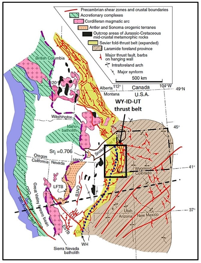
Generalized tectonic map of the western United States showing the major elements of the Cordilleran orogenic belt. The Sr ratio line (dashed purple) is the boundary between marine crust and thinned continental crust. The Wasatch Hingeline (WH, dotted blue) is the boundary between normal and thinned continental crust. The thrust belt terrane is highlighted yellow. Abbreviations: LFTB, Luning-Fenster thrust belt; CNTB, Central Nevada thrust belt; ESTB, East Sierra thrust Belt; UU, Uinta Mountains uplift; WH, Wasatch hinge line; CM, Clark Mountains, CRO, Coast Range Ophiolite.
Image: After De Celles, P.G., and Coogan, J.C., 2006, Regional structure and kinematic history of the Sevier fold-and-thrust belt, central Utah: Geological Society of America Bulletin 118, Fig. 1, p. 842; http://terra.rice.edu/department/faculty/morganj/ESCI536/Readings/sevier/DeCellesCoogan-GSABull2006.pdf.
Image: After De Celles, P.G., and Coogan, J.C., 2006, Regional structure and kinematic history of the Sevier fold-and-thrust belt, central Utah: Geological Society of America Bulletin 118, Fig. 1, p. 842; http://terra.rice.edu/department/faculty/morganj/ESCI536/Readings/sevier/DeCellesCoogan-GSABull2006.pdf.
Paleogeography of southwestern North America 80 million years ago (Ma). This was about the time movement was stopping on the Crawford Thrust Fault and movement was beginning on the Absaroka Thrust Fault.
Image: After Blakey, R. C., and Ranney, W., 2018, The Continental Arc, Sevier Orogeny, Western Interior Seaway and Flat-Slab Subduction: Cretaceous Period: Ca. 145–65 Ma. 10.1007/978-3-319-59636-5_8, Fig. 8.12, p. 128; https://www.researchgate.net/publication/320213634_The_Continental_Arc_Sevier_Orogeny_Western_Interior_Seaway_and_Flat-Slab_Subduction_Cretaceous_Period_Ca_145-65_Ma.
Image: After Blakey, R. C., and Ranney, W., 2018, The Continental Arc, Sevier Orogeny, Western Interior Seaway and Flat-Slab Subduction: Cretaceous Period: Ca. 145–65 Ma. 10.1007/978-3-319-59636-5_8, Fig. 8.12, p. 128; https://www.researchgate.net/publication/320213634_The_Continental_Arc_Sevier_Orogeny_Western_Interior_Seaway_and_Flat-Slab_Subduction_Cretaceous_Period_Ca_145-65_Ma.
Generalized regional cross section from the western subduction zone, through the Sevier tectonic zone to the Rocky Mountain foreland. Approximate location of cross section shown by dotted line on tectonic index map above.
Image: http://www.luckysci.com/2015/10/how-the-west-was-made-western-north-american-orogenies/
Image: http://www.luckysci.com/2015/10/how-the-west-was-made-western-north-american-orogenies/
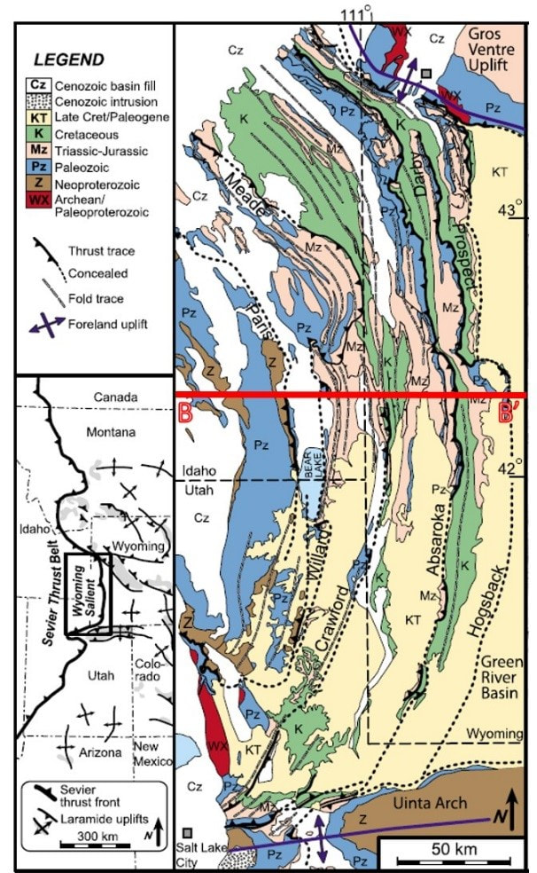
Generalized geologic map of the Wyoming-Idaho-Utah thrust belt. Red line shows location of cross section BB’.
Image: After Weil, A.B., 2010, Quantifying vertical axis rotation in curved orogens: Correlating multiple data sets with a refined least squares strike test: Tectonics, Vol. 29, TC3012, Fig. 6, p. 12; https://www.researchgate.net/publication/234865537_Quantifying_vertical_axis_rotation_in_curved_orogens_Correlating_multiple_data_sets_with_a_refined_weighted_least_squares_strike_test.
Image: After Weil, A.B., 2010, Quantifying vertical axis rotation in curved orogens: Correlating multiple data sets with a refined least squares strike test: Tectonics, Vol. 29, TC3012, Fig. 6, p. 12; https://www.researchgate.net/publication/234865537_Quantifying_vertical_axis_rotation_in_curved_orogens_Correlating_multiple_data_sets_with_a_refined_weighted_least_squares_strike_test.
Geologic cross section BB’ across the middle of the Wyoming salient of the thrust belt. The Paleozoic beds are detached from the basement rock and moving along Cambrian shale glide planes before ramping up section. Generally, the older faults are to the west and higher in the stack. Folded, stack blocks of Phanerozoic stratigraphic rocks lie on the fault planes. Location of cross section BB’ shown on geologic map above.
Image: After Tikoff, B., Blenkinsop, T., Kruckenberg, S.C., Morgan, S., Newman, J., Wojtal, S., 2013, A perspective on the emergence of modern structural geology: Celebrating the feedbacks between historical-based and process-based approaches: Geological Society of America Special Paper 500, Fig. 8, p. 80; https://www.researchgate.net/publication/262698618_A_perspective_on_the_emergence_of_modern_structural_geology_Celebrating_the_feedbacks_between_historical-based_and_process-based_approaches.
Image: After Tikoff, B., Blenkinsop, T., Kruckenberg, S.C., Morgan, S., Newman, J., Wojtal, S., 2013, A perspective on the emergence of modern structural geology: Celebrating the feedbacks between historical-based and process-based approaches: Geological Society of America Special Paper 500, Fig. 8, p. 80; https://www.researchgate.net/publication/262698618_A_perspective_on_the_emergence_of_modern_structural_geology_Celebrating_the_feedbacks_between_historical-based_and_process-based_approaches.
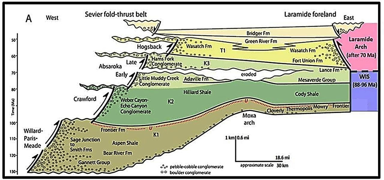
Sedimentary deposits in the Wyoming foreland basin during movement of the principal faults of the Sevier fold-thrust belt. Note that the sedimentary rocks become thicker and coarser grained closer to the thrust faults (west). Almost all of these rocks are clastic (gravels, sand, silt and clay).
Image: Image: After Yonkee, W.A. and Weil, A.B., 2015, Tectonic evolution of the Sevier and Laramide belts within the North American Cordillera orogenic system: Earth-Science Reviews 150, Fig. 12A, p. 550.
Image: Image: After Yonkee, W.A. and Weil, A.B., 2015, Tectonic evolution of the Sevier and Laramide belts within the North American Cordillera orogenic system: Earth-Science Reviews 150, Fig. 12A, p. 550.
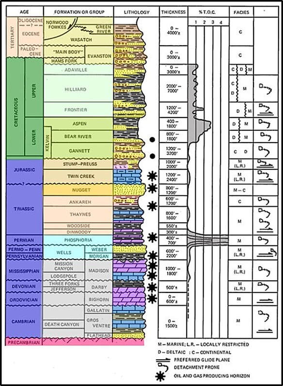
Stratigraphic column in the Wyoming-Idaho-Utah thrust belt area showing thickness of formations, productive formations, percent of total organic carbon (TOC), generalized depositional environment, and preferred detachment horizons and glide planes. Formation colors are the same as in cross section BB’. Movement on the thrust faults occurred from late Jurassic through Eocene.
Image: After Lamerson, P.R., 1982, The Fossil Basin and its Relationship to the Absaroka Thrust System, Wyoming and Utah: Rocky Mountain Association of Geologists in Powers, R.B., Editor-in-Chief, Geologic Studies of the Cordilleran Thrust Belt, Vol. 1, Fig. 4, p. 287.
Image: After Lamerson, P.R., 1982, The Fossil Basin and its Relationship to the Absaroka Thrust System, Wyoming and Utah: Rocky Mountain Association of Geologists in Powers, R.B., Editor-in-Chief, Geologic Studies of the Cordilleran Thrust Belt, Vol. 1, Fig. 4, p. 287.
Wyoming Thrust Belt Hydrocarbon Exploration and Production
Oil seeps were relatively common along the Emigrant Trails in the toe of the Absaroka thrust in southwesternmost Wyoming. Three seeps were used by travelers and sold by merchants. Bridger and Vasquez were aware of the Hilliard oil seep in northwest, Section 4, Township 13 North, Range 119W when they built Fort Bridger in 1842. Brigham Young discovered the seep on the first migration of Mormons to Utah in 1848. Brigham sent workers back to the site from Salt Lake to develop the seep to sell oil to future Mormon emigrants and in Salt Lake City. The site, now Brigham Young’s oil seep, is reported in William Clayton’s 1848 Latter-Day Saints’ Emigrants’ Guide
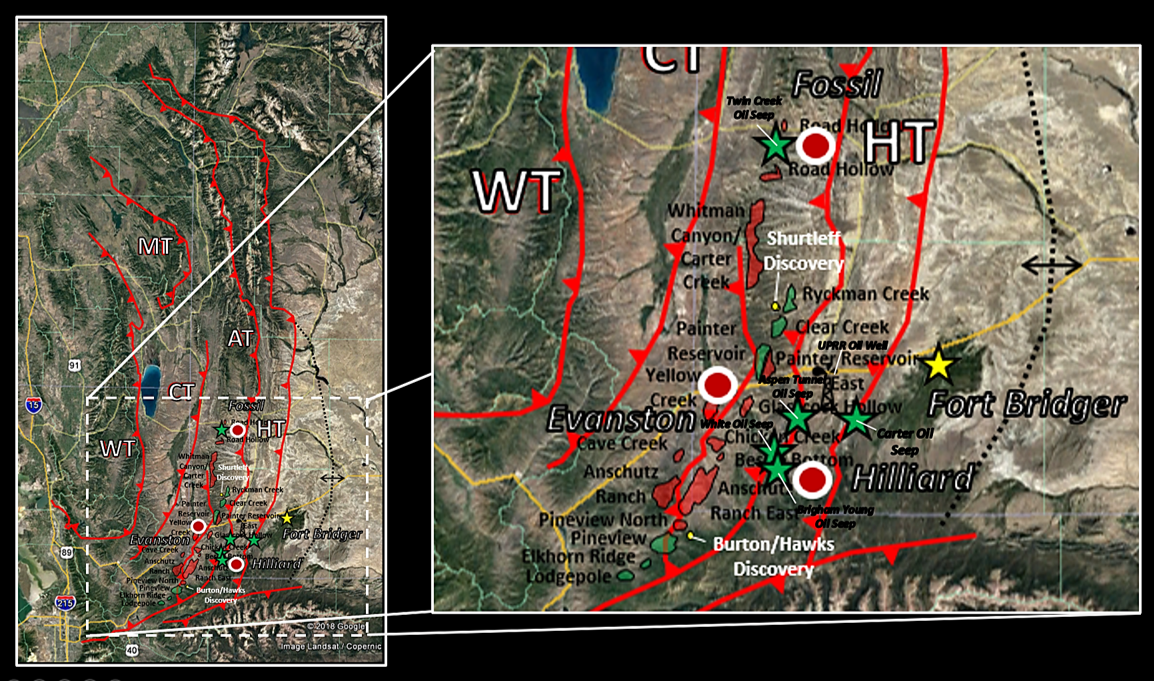
Oil seeps in the southern portion of the thrust belt near Absaroka fault system toe. Abbreviations are the same as on the index map above.
Image: Google Earth; Data from Lamerson, P. R., 1982, The Fossil Basin and its Relationship to the Absaroka Thrust System, Wyoming and Utah: in Powers, R.B., Editor-in Chief, Geologic Studies of the Cordilleran Thrust Belt, Vol. 1: Rocky Mountain Association of Geologists and the Denver Geophysical Society.
Image: Google Earth; Data from Lamerson, P. R., 1982, The Fossil Basin and its Relationship to the Absaroka Thrust System, Wyoming and Utah: in Powers, R.B., Editor-in Chief, Geologic Studies of the Cordilleran Thrust Belt, Vol. 1: Rocky Mountain Association of Geologists and the Denver Geophysical Society.
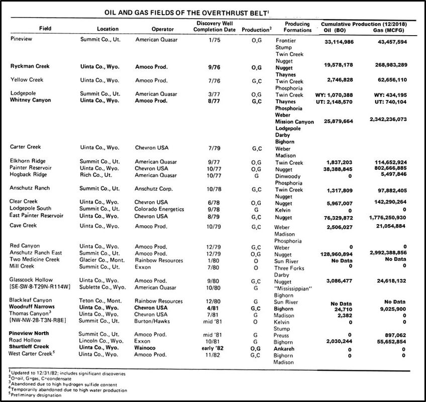
Oil and gas fields discovered in the Wyoming-Utah thrust belt oil boom, mid-1970s to mid-1980s.
Image: After Zonge International website, accessed Jan. 7, 2019;
http://www.zonge.com/legacy/PDF_Papers/IP-Petro_3.pdf.
Image: After Zonge International website, accessed Jan. 7, 2019;
http://www.zonge.com/legacy/PDF_Papers/IP-Petro_3.pdf.
William Carter, sutler at Fort Bridger, skimmed oil from a seep discovered in 1867. He mixed the oil with flour and sold it to emigrants as axle grease, polish, and lineament for man or beast. While tunneling for coal in 1868, an oil seep that flowed eight to ten gallons per day was cut at 240-foot distance. The oil was sold to local coal mines as a lubricant. Carter sold 150 barrels to the newly arrived Union Pacific Railroad the following year. Three wells were drilled in 1886 in the vicinity. Two of the wells reportedly made 6 barrels of oil per day (bopd) from 225 to 300 feet deep.
Judge C.M. White dug a trench just north of the Brigham Young oil spring at northwest, Section 33, Township 14 North, Range 119 West and had oil flow to the surface in 1867. He sold the product to tanners in Salt Lake City and to the railroad when the Union Pacific extended the line nearby. He drilled a nearby well in 1868, but the well was abandoned at 460 feet due to the spring pole tool getting stuck in the hole. Evanston Oil Company drilled near the seep in 1884 but ran out of money at a 400-foot depth and abandoned the well.
There are also reports of seeps to the north at Fossil, 10 miles west of Kemmerer. These are probably the oil springs reported by F. W. Lander as he inspected the emigrant cutoff route to Oregon along the South Fork of Twin Creek in Township 21 North, Range 117 West. Twin Creek Oil drilled two wells here of 110 and 185 feet in 1885, that recovered a large volume of brackish, sulfur water. They also recovered a slight cut of oil and gas.
In 1899 the railroad began construction of the Aspen tunnel. They cut an oil seep that flowed for 30 to 40 days at 200 to 300 gallons per day (5-7 bopd). A fault at the toe of the Absaroka fault runs through the western end of the tunnel. All the seeps found in the 19th century, except Carter seep, were also located along the same fault system. The Carter is in the foot wall of the Hogsback thrust.
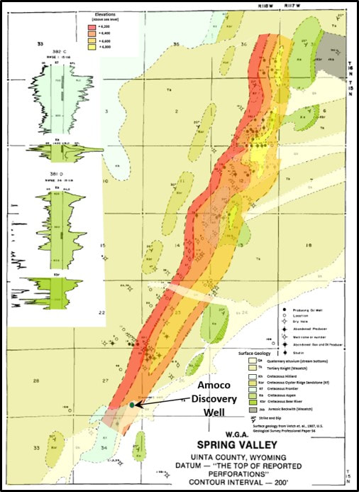
The first oil boom in the thrust belt was sparked when the Union Pacific drilled a water well in northeast, northeast Section 27, Township 15 North, Range 118 West and recovered oil in 1901. This was the discovery well for Spring Valley Field which produces waxy oil from the Frontier, Aspen and Bear River. The Aspen Tunnel seep occurred about the same time. Oil fever spread throughout the country with a flood of speculative oil claims filed under the placer-mining laws. Over 31 oil companies quickly came to Evanston. Exploratory wells focused on the oil seep areas in the complex terrane. With marginal results, the companies flooded away from Evanston.
Structure and surface geology map of Spring Valley Field.
Image: After Kelly, B., 1992, Spring Valley: Wyoming Geological Association Wyoming Oil and Gas Fields Symposium, Greater Green River Basin and Overthrust Belt, p. 292.
Image: After Kelly, B., 1992, Spring Valley: Wyoming Geological Association Wyoming Oil and Gas Fields Symposium, Greater Green River Basin and Overthrust Belt, p. 292.
The U.S. Geological Survey geologist A.C. Veatch described and mapped the geology of the area in 1907. Some exploration began again in the war and post-war years of the 1940s and 1950s and discovered nothing but dry holes. Surface anticlines were the focus of their efforts. Lack of success was due to there lack of understanding of the architecture of the structures. The early dipmeters (1942 & 1947) required hand interpretation and were prone to many pitfalls. The modern dipmeter tool that accurately showed the dip of the rocks penetrated was not available until 1969.
With new seismic and accurate dipmeter data, industry began to look at this under-explored region again. This time hydrocarbons would be found. By 1971, the Occidental Petroleum management had pretty much decided that the thrust belt was a “driller’s graveyard” given the 200 dry holes previously drilled by exploration companies. They had a seismic option farmin on almost a million acres on the Union Pacific right-of-way from Fort Bridger to Salt Lake and a commitment to spend $600,000 on seismic acquisition and processing. They could earn ¾ of 12 checkerboard sections by drilling a 12,000 foot test well. Final earnings depended on Pan American’s Company election decision on participating in well. Pan American elected not to join, but Sun Oil took a 50% interest. The Oxy #1 well was a 12,500 test of the Pennsylvanian Weber Sandstone (prognosed at 11,000 foot) on the Pineview structure. The well site was located using Oxy seismic data at the east half, southeast, Section 5, Township 2 North, Range 7 East, Summit County, Utah. The location was west of the surface anticline crest to reach the predicted asymmetric Weber Formation crest on the structure.
The prognosed Weber seismic event turned out to be the Jurassic Nugget. The penetrated sandstone had oil shows, but a drill stem test recovered only slightly gas cut brackish water. The overlying Twin Creek was not tested but the dipmeter showed six degrees west dip. The error in the prognosis was due to a lack of seismic ties for an accurate time depth conversion. Geology wanted to continue drilling to the Weber, but management refused. The well was plugged and abandoned at an unearning depth of 10,530 feet in the Nugget Sandstone. Occidental closed their Rocky Mountain Office as the ongoing Libyan crisis continued (Libya nationalized 51% of all of Occidental’s assets in 1973. Oxy’s main oil production came from Libya).
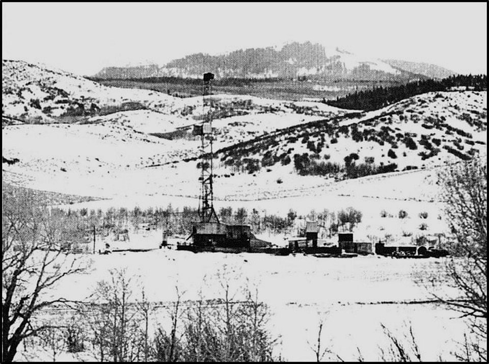
The Pineview project was up for sale promoted by the same project geologist, with two possible drill targets, the deep Weber near the original drill site or the up-dip Nugget to the east. American Quasar bought the project and chose to move about a mile east to test the oil stained up dip Nugget. The #1 Newton Sheep was spud February 1973 in the northeast, southeast, Section 4, Township 2 North, Range 7 East. When the well was completed with an initial potential flowing 540 BO (45o gravity), 226 BW, and 270 MCFGPD from 250 feet of Nugget pay in January 1975. The “drillers graveyard” was about to become “elephant country.”
American Quasar Newton Sheep #1 drilling rig on location.
Image: After Hull, J.P., 1977, Discovery of Pineview Oil Field: Rocky Mountain Association of Geologists, The Mountain Geologist Vol. 36, No. 4, Fig. 4, p. 206.
Image: After Hull, J.P., 1977, Discovery of Pineview Oil Field: Rocky Mountain Association of Geologists, The Mountain Geologist Vol. 36, No. 4, Fig. 4, p. 206.
Pineview Field Nugget Sandstone structure map showing location of Oxy dry hole, American Quasar’s Newton Sheep discovery and cross section AA’. The oil-water contact is marked by the green dashed line.
Image: After Conner, D.C., and Covlin, R.J., 1977, Development Geology of Pineview Field, Summit County, Utah: Wyoming Geological Association Guidebook Twenty-Ninth Annual Field Confer, Fig. 3, p. 643.
Image: After Conner, D.C., and Covlin, R.J., 1977, Development Geology of Pineview Field, Summit County, Utah: Wyoming Geological Association Guidebook Twenty-Ninth Annual Field Confer, Fig. 3, p. 643.
Structural cross section of Pineview Field with location of wells mentioned in the text.
Image: After Conner, D.C., and Covlin, R.J., 1977, Development Geology of Pineview Field, Summit County, Utah: Wyoming Geological Association Guidebook Twenty-Ninth Annual Field Confer, Fig. 4, p. 644.
Image: After Conner, D.C., and Covlin, R.J., 1977, Development Geology of Pineview Field, Summit County, Utah: Wyoming Geological Association Guidebook Twenty-Ninth Annual Field Confer, Fig. 4, p. 644.
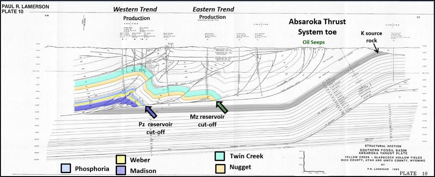
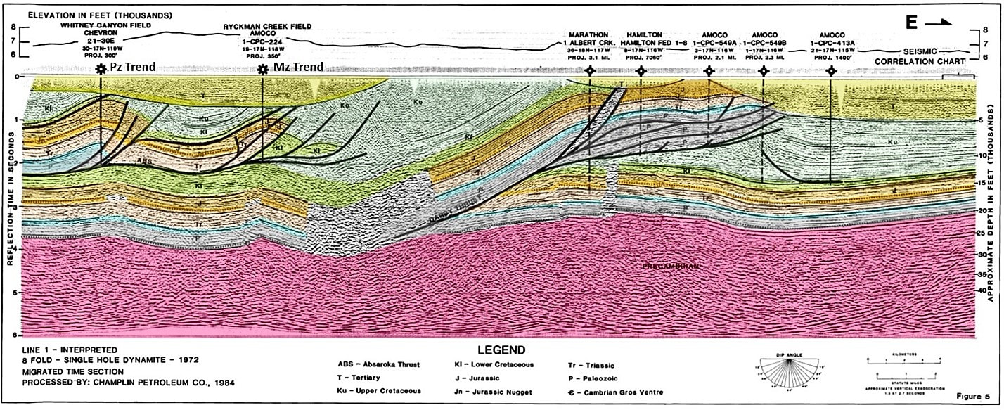
The #1 Sheep Newton discovery well ignited the oil boom mid-1970s-1980s throughout the Rocky Mountain thrust belt. By the time the boom was over at least 20 fields had been discovered on the Absaroka thrust plate. There were two productive trends, the western trend aligned with the fault cutoff of the Paleozoic section and the second at the fault cutoff of the Jurassic Twin Creek. The source of the oil is believed to be the organic-rich marine Cretaceous shales in the footwall (below the thrust fault). As of December 2018, the thrust belt fields of Wyoming and Utah have a cumulative production of about 368 million barrels of oil and 5.6 trillion cubic feet of gas.
Structural cross section of Absaroka thrust block showing the two productive trends. Location of Plate 10 shown on Index Map below.
Image: After Lamerson, P.R., 1982, The Fossil Basin and Its Relationship to the Absaroka Thrust System, Wyoming and Utah, in Powers, R.B., Editor-in-Chief, Geologic Studies of the Cordilleran Thrust Belt, Volume 1, Rocky Mountain Association of Geologists, Plate 10.
Image: After Lamerson, P.R., 1982, The Fossil Basin and Its Relationship to the Absaroka Thrust System, Wyoming and Utah, in Powers, R.B., Editor-in-Chief, Geologic Studies of the Cordilleran Thrust Belt, Volume 1, Rocky Mountain Association of Geologists, Plate 10.
Seismic Line through the Absaroka and Darby Thrust.
Image: After Williams, W.D., and Dixon, J.S., 1985, Seismic Interpretation of the Wyoming Overthrust: in Gries, R.R., and Dyer, R.C., Editors, Seismic Exploration of the Rocky Mountain Region: Rocky Mountain Association of Geologists and Denver Geophysical Society, Fig. 5, p.17.
Image: After Williams, W.D., and Dixon, J.S., 1985, Seismic Interpretation of the Wyoming Overthrust: in Gries, R.R., and Dyer, R.C., Editors, Seismic Exploration of the Rocky Mountain Region: Rocky Mountain Association of Geologists and Denver Geophysical Society, Fig. 5, p.17.
The success of any exploration play requires a thorough understanding of the elements and process of the petroleum system. The elements include source, reservoir, seal, and overburden. Processes include the timing of trap formation and timing of oil generation, expulsion, migration, and accumulation. Missing or inaccurate data adds risk to a prospect. It also requires an exploration team that can convince management to invest in the project. There are also factors beyond your control such as market price of oil, government regulations, and world events. And finally, there is luck that any errors (and there usually are some) are not critical to the success of the well. In 1975, these factors came favorably together and lead to the discovery of Pineview Field and the beginning of a new Overthrust play.
A post-discovery cross section by Gerald G. Loucks, the geologist leading the team that generated the drilling of both the Oxy #1 and the Newton Sheep discovery well demonstrates that serendipity plays a role in the best geologic prospects.
A post-discovery cross section by Gerald G. Loucks, the geologist leading the team that generated the drilling of both the Oxy #1 and the Newton Sheep discovery well demonstrates that serendipity plays a role in the best geologic prospects.
West-east cross section through Pineview and Bridger Lake fields. Thrusting, if present, omitted. American Quasar chose wisely when they drilled up dip from oil stained Nugget. Formation colors as in the stratigraphic column shown above. Three elements of the petroleum system not identified are noted below cross section. As the play evolved through the work of geologists and geophysicists at Chevron, Union Pacific Resources, Amoco, Mobil and Exxon the structure of the Sevier Orogeny became understood.
Image: After Loucks, G.G., 1975, The Search for Pineview Field, Summit County, Utah: Rocky Mountain Association Symposium on Deep Drilling Frontiers in the Central Rocky Mountains, Fig. 15, p. 263.
Image: After Loucks, G.G., 1975, The Search for Pineview Field, Summit County, Utah: Rocky Mountain Association Symposium on Deep Drilling Frontiers in the Central Rocky Mountains, Fig. 15, p. 263.
Paul Lamerson’s west-east cross section (1982) of Pineview Field displaying a more accurate view of the Sevier Orogenic structure. Note detachment faulting on in the mechanically weak beds of the Jurassic Stump Formation evaporites (lateral equivalent of the Gypsum Spring Formation). Ramp anticline closure developed by the cutoff of the Jurassic Nugget and Twin Creek Formations on the Absaroka thrust glide plane through the Triassic. Juxtaposition of Jurassic reservoir rocks on subthrust Cretaceous source rocks provides a pathway for the oil to move from source to reservoir. Also note that the Nugget and Twin Creek have a common oil water contact. Occidental’s #1 Pineview dry hole was reentered in 1977 and completed in the Twin Creek Limestone flowing 368 barrels of oil, 143 MCF gas and 63 barrels of water from a one-foot zone (9,414-9,415). The original well was drilled with an overweight mud system, had no shows in the Twin Creek and was untested. The productive re-entry well was renamed the 5-1 UPRR.
Image: Chidsey, T.C., Jr., and Sprinkle, D.A., 2005, Major Oil Plays in Utah and Vicinity: Quarterly Technical Progress Report: Contract No. DE-FC26-02NT15133, Utah Geologic Survey and U.S. Department of Energy, Fig. 10, p.12; https://geology.utah.gov/docs/emp/pump/pdf/pumprpt9.pdf.
Image: Chidsey, T.C., Jr., and Sprinkle, D.A., 2005, Major Oil Plays in Utah and Vicinity: Quarterly Technical Progress Report: Contract No. DE-FC26-02NT15133, Utah Geologic Survey and U.S. Department of Energy, Fig. 10, p.12; https://geology.utah.gov/docs/emp/pump/pdf/pumprpt9.pdf.
Things-To-Do
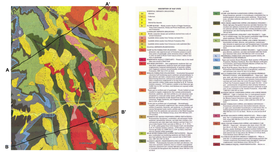
The landscape of Lincoln and Uinta Counties is dominated by long north-south oriented mountains and ridges created by the low-angle thrust faults. One of the best places to see folded and thrusted rocks is to drive southeast from Hoback Junction on US 191/US 189 along the Hoback River. Directions from Jackson: head south out of Jackson on US 191 South/US 26 West/US 89 South, drive 13 miles to the roundabout in Hoback Junction and take second exit onto US 189 South/US 191 South heading toward Bondurant. The 11 mile scenic drive from Hoback Junction to the turn off on your left (north) on Granite Road/Granite Creek Road/ Forest Service Road 30500 has numerous outcrops of thrusted rocks. This Forest Service gravel road takes you to Granite Hot Springs. To the southeast of this intersection of Granite Creek and Hoback River is Battle Mountain, where the Nugget Sandstone has been thrusted over the Paleocene Hoback Formation on the Prospect Thrust Fault (see picture and geologic map below). To the northwest of this intersection is a high ridge of Nugget Sandstone that has also been thrusted into its current position by the Prospect Thrust. The Geological Society of America Centennial Field Guide gives a geologic description from Hoback Junction heading south toward Bondurant (Dorr, et al.,1987, Hoback River Canyon, Wyoming: GSA Centennial Field Guide – Rocky Mountain Section, Field Trips Stops 1, 2, 3 & 4 on pages 197 – 200). The Wyoming Geological Survey publication Geologic Field Tours of Western Wyoming, 1990, Public Information Circular No. 29 gives a geologic description of the thrust faults and rocks from the Granite Creek/Hoback River intersection back to Hoback Junction (Field Trip Stops 1 & 2 on pages 97-99, https://www.wsgs.wyo.gov/products/wsgs-1990-pic-29.pdf).
East face of Battle Mountain with the Jurassic Nugget (Jn) thrusted eastward over the younger Tertiary Hoback Formation (Th). Prospect (Cliff Creek)Thrust Fault marked with red dashed line.
Image: Mark Fisher
Image: Mark Fisher
Geologic map of the Hoback River, Battle Mountain and Granite Creek areas
Schroeder, M.L., 1976, Geologic map of the Bull Creek quadrangle, Teton and Sublette Counties, Wyoming: U.S. Geological Survey Geologic Quadrangle Map GQ-1300; https://ngmdb.usgs.gov/Prodesc/proddesc_10835.htm
Schroeder, M.L., 1976, Geologic map of the Bull Creek quadrangle, Teton and Sublette Counties, Wyoming: U.S. Geological Survey Geologic Quadrangle Map GQ-1300; https://ngmdb.usgs.gov/Prodesc/proddesc_10835.htm
Another interesting place to experience the thrust belt is the drive and hike east of Afton up Swift Creek to the Periodic Spring. The journey to the spring passes a number of thrust belt folds with steeply dipping rocks. See our Periodic Spring website to obtain instructions on how to get to the spring and what you will see. The spring is amazing in late summer and fall when it magically turns on and off in a big way!

The material on this page is copyrighted
