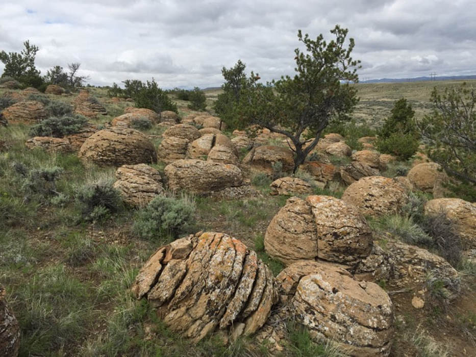
Large concretions eroded out of Frontier Sandstone at Thermopolis Anticline
Photo by Mark Fisher
Photo by Mark Fisher
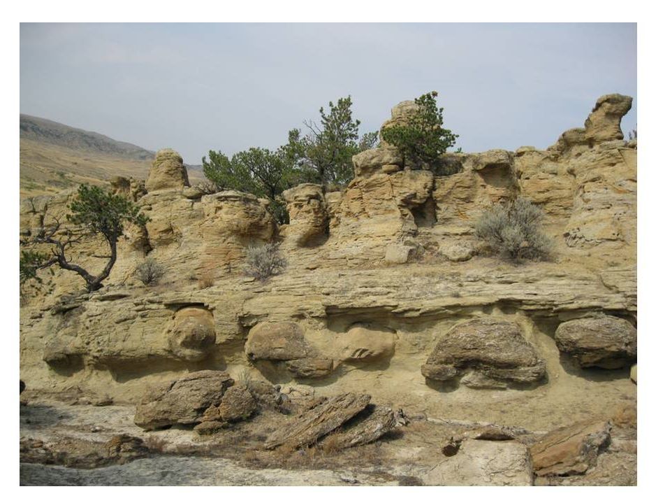
Large concretions encased in Frontier Sandstone at Thermopolis Anticline
Photo by Mark Fisher
Photo by Mark Fisher
Wow Factor (2 out of 5 stars):

Geologist Factor (2 out of 5 stars):

Attraction
A field of giant spherical boulders that are calcite cemented sandstone concretions. Formed in the shallow subsurface during the Cretaceous, they are unusual for their large number, impressive size and concentration in a football field sized area.
Geology of Dinosaur Marbles
Geologic features are often given descriptive non-scientific names by local people. Spheroid-shaped stones have been erroneously interpreted as fossil plant, animal or alien lifeforms. Terms like seed pod, dinosaur egg or an extraterrestrial cocoon have been applied. Sometimes they resemble marbles, golf balls, shot-puts, bowling balls or cannon balls depending on their shape and size. They have also been attributed to a race of giants, with legendary character names added such as Paul Bunyan or Pecos Bill.
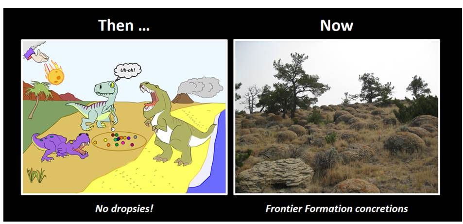
Not to be outdone by non-professionals, we call the spheroid-shaped features seen on the north nose of the Thermopolis Anticline, "Dinosaur marbles." They are concretions developed in the Late Cretaceous Frontier Formation. This formation was deposited near the end of the age of dinosaurs.
Not to be outdone by non-professionals, we call the spheroid-shaped features seen on the north nose of the Thermopolis Anticline, "Dinosaur marbles." They are concretions developed in the Late Cretaceous Frontier Formation. This formation was deposited near the end of the age of dinosaurs.
Author's suggested origin of Late Cretaceous Frontier Formation concretions on Thermopolis Anticline.
Dinosaur Marbles cartoon by Ken Steele
Concretion image: Fisher, M., 2017
Dinosaur Marbles cartoon by Ken Steele
Concretion image: Fisher, M., 2017
The concretion field encompasses an area of about 0.65 acres (one-half a football field) on the north nose of the Thermopolis Anticline about a mile east of Wyoming Highway 120, off a dirt road. The Thermopolis Anticline is a 30-mile long fold created by Laramide compressional tectonics about 70 million years ago. The fold is oriented northwest-southeast, asymmetrical with the steep flank to the southwest (see structural cross section 3 below). The anticline is segmented into three pieces by left lateral tear faults aligned parallel to the cross cutting streams. The concretions are developed in an upper sand of the Late Cretaceous Frontier Formation (89 to 97 million years ago).

Aerial view of Dinosaur Marbles site (yellow star), Thermopolis Anticline.
Image: Google Earth
Image: Google Earth
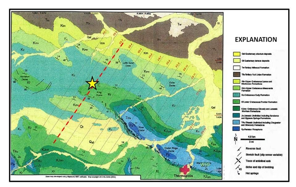
Geologic map of Dinosaur Marbles site (yellow star), Thermopolis Anticline. Dashed red line: dip cross section 3.
Image: Zahm, C.K., 2002, 3D Strain and Basement Involved Folding, Thermopolis Anticline, Wyoming: Ph.D. Dissertation Colorado School of Mines, Fig. 5-2, p. 94.
Image: Zahm, C.K., 2002, 3D Strain and Basement Involved Folding, Thermopolis Anticline, Wyoming: Ph.D. Dissertation Colorado School of Mines, Fig. 5-2, p. 94.

North aerial views of Dinosaur Marble site 1 mile east of WY highway 120 (left). Closer view of the concretion field (right).
Images: Google Earth
Images: Google Earth
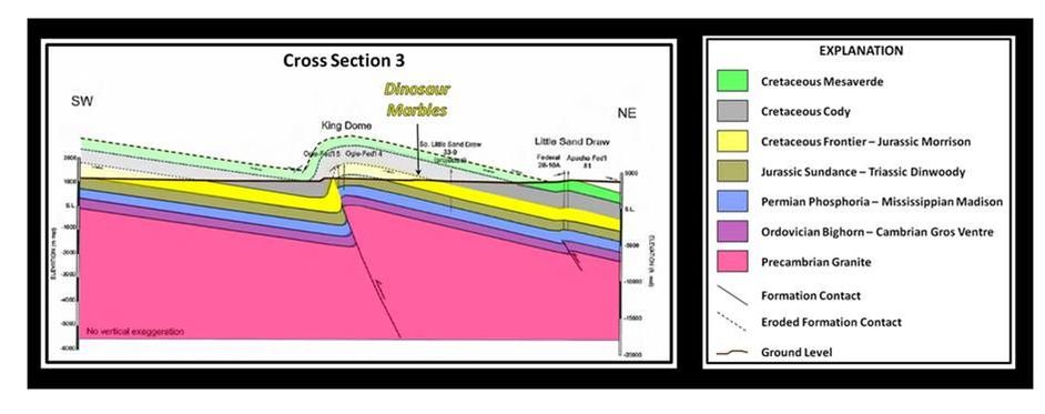
Structural cross section 3 over Thermopolis Anticline.
Image: Zahm, C.K., 2002, 3D Strain and Basement Involved Folding, Thermopolis Anticline, Wyoming: Ph.D. Dissertation Colorado School of Mines, Fig. 6-7, p.150.
Image: Zahm, C.K., 2002, 3D Strain and Basement Involved Folding, Thermopolis Anticline, Wyoming: Ph.D. Dissertation Colorado School of Mines, Fig. 6-7, p.150.
A concretion is a feature formed during diagenesis (physical and chemical changes occurring during the conversion of sediment to sedimentary rock). As sediments are buried by younger sediments they undergo compaction. Mineral bearing fluids move through pore spaces and deposit cement, often on a piece of organic matter. Due to the good porosity and permeability of sand, the cement grows outward in three dimensions from the original point of cementation. This creates a spheroid-shaped area of harder cemented rock that is more resistant to erosion than adjacent areas. Thus, the concretions did not exist on the surface as “marbles”. They formed in the subsurface by cementation. The diagrams below illustrate two models for carbonate concretions and how bedding can indicate concretion growth versus the timing of sediment compaction.
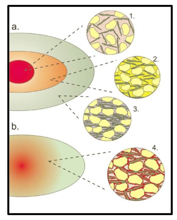
Diagram illustrating two different models for concretion growth (a. and b.). The cartoons on the right (1–4) illustrate differences in microfabric which can be seen in thin section (rounded grains represent silt-sized quartz or feldspar and elongate, dark green, grains represent clays). a. Simple concentric growth where the concretion has grown in discrete stages (differently colored ‘cements’) from the center outwards. The different orientation and distribution of the grains in 1, 2 and 3 demonstrate that the concretion grew at three discrete times during compaction. Note that there is much more carbonate (pink) between the grains in the early zone (1) than (blue) in the zone which formed after compaction. The second concretion (b. 4) has a mixed fabric resulting from incomplete cementation by a first generation of carbonate (red) and later cementation by a second generation (blue). The body of the concretion will have a mixed fingerprint with samples containing both cement types.
Image: Marshall, J. and Pirrie, D., 2013, Carbonate concretions—explained: The Geologists’ Association & The Geological Society of London, Geology Today, Vol. 29, No. 2, Fig. 7, p. 56; https://www.researchgate.net/publication/264455545_Carbonate_concretions-explained
Image: Marshall, J. and Pirrie, D., 2013, Carbonate concretions—explained: The Geologists’ Association & The Geological Society of London, Geology Today, Vol. 29, No. 2, Fig. 7, p. 56; https://www.researchgate.net/publication/264455545_Carbonate_concretions-explained

Left: Diagram showing how field observations can allow us to work out the timing of concretion growth relative to sediment compaction. Ellipses represent the outer margin of the concretion. In all cases the layers were initially planar horizontal bedding or lamination and can be traced through and around the concretions: a. early diagenetic concretion formed before compaction. b. early diagenetic concretion which continued to grow during compaction (layers are deformed inside and outside the concretion); c. and d. represent concretions that formed after compaction. Ovoid concretions (c.) are more common in mudstones whilst more spherical bodies (d.) occur in sandstones. This reflects the differences in horizontal and vertical permeability in the different sediment types. Right: Image of concretion showing (b) sediment compaction, weathering from outcrop.
Images: Left: Marshall, J. and Pirrie, D., 2013, Carbonate concretions—explained: The Geologists’ Association & The Geological Society of London, Geology Today, Vol. 29, No. 2, Fig. 8, p. 57; https://www.researchgate.net/publication/264455545_Carbonate_concretions-explained ; Right: Fisher, M., 2017
Images: Left: Marshall, J. and Pirrie, D., 2013, Carbonate concretions—explained: The Geologists’ Association & The Geological Society of London, Geology Today, Vol. 29, No. 2, Fig. 8, p. 57; https://www.researchgate.net/publication/264455545_Carbonate_concretions-explained ; Right: Fisher, M., 2017
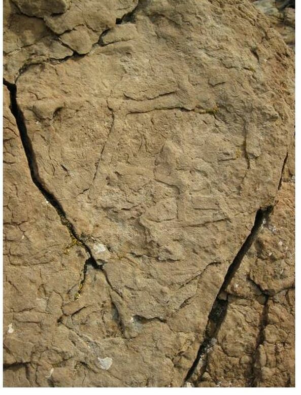
Burrow traces in the interior of concretions at Dinosaur Marbles. Concretions commonly form around the organic remains of plants and animals. No fossils or organic matter were observed in the Dinosaur Marble concretions, but they are riddled with burrows, also known as trace fossils. These may be shrimp burrows.
Image: Fisher, M., 2017
Image: Fisher, M., 2017
Geology Frontier Formation
During the Late Cretaceous abundant sediment eroded from the Sevier Highlands and was transported eastward by streams flowing into the Western Interior Seaway. These sands accumulated in a complex of deltaic, beach and shallow marine environments. The Frontier Formation sands are sediments derived from the late movement on the Willard and Meade Thrusts, and during early movement on the Crawford thrust.

Late Cretaceous lithospheric cross section A-A’ of western North America tectonics. Events depicted include: 1) subduction zone at converging plate margins, 2) accretionary wedge (material sheared off descending plate and attached to the upper plate), 3) development of the volcanic arc (developed above the rock melting point of the descending plate), 4) crustal thickening in the hinterland (includes accreted terrain and rifted cratonic crust), 5) formation of the Sevier fold and thrust belt localized at the Wyoming Craton western edge (close-up cross section B-B’), 6) Sedimentation into the Sevier foreland and Western Interior Seaway, and 7) the future location of the development of Laramide Arch structures (close-up cross section C-C’).
Image: After Yonkee, W.A. and Weil, A.B., 2015, Tectonic evolution of the Sevier and Laramide belts within the North American Cordillera orogenic system: Earth-Science Reviews 150, Fig. 6C, p. 542; Weil, A.B. and Yonkee, W.A., 2012, Earth and Planetary Science Letters 357–358, Fig. 2, p. 408
Image: After Yonkee, W.A. and Weil, A.B., 2015, Tectonic evolution of the Sevier and Laramide belts within the North American Cordillera orogenic system: Earth-Science Reviews 150, Fig. 6C, p. 542; Weil, A.B. and Yonkee, W.A., 2012, Earth and Planetary Science Letters 357–358, Fig. 2, p. 408
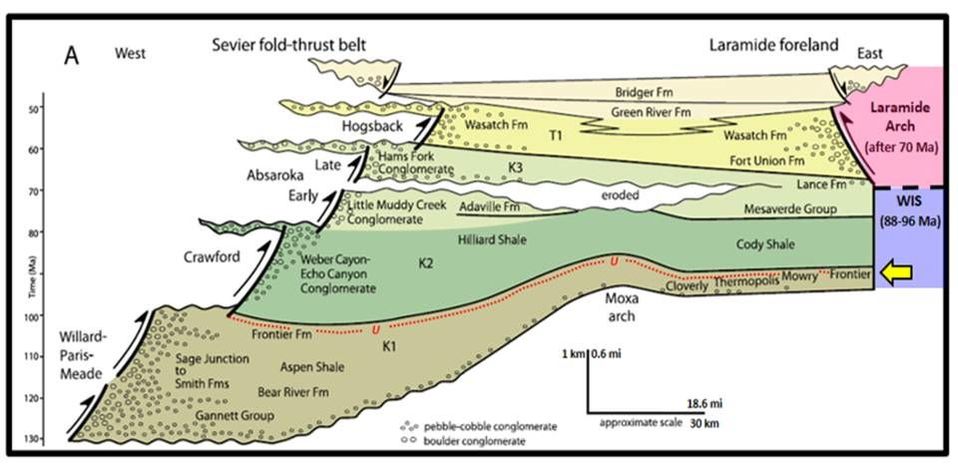
Timing of compressional movement on Sevier mountain building thrust faults along the west edge of Wyoming and the associated sediment packages deposited eastward across Wyoming. Yellow arrow shows position of the Frontier Formation on the stratigraphic diagram. Red dotted line marks the approximate position of a major erosional event during the Frontier Formation. WIS: Western Interior Seaway. K1 — Early Cretaceous deposition during Willard–Paris–Meade thrusting; K2— mid Cetaceous deposition during Crawford thrusting along with regional subsidence; K3— mid and later Cretaceous deposition during early and late Absaroka thrusting, separated by a local erosional event; T1 — Paleocene to Early Eocene sedimentation during Hogsback thrusting and Laramide mountain building; and later Eocene deposition in local half grabens during a switch from compression to extension.
Image: After Yonkee, W.A. and Weil, A.B., 2015, Tectonic evolution of the Sevier and Laramide belts within the North
American Cordillera orogenic system: Earth-Science Reviews 150, Fig. 12A, p. 550.
Image: After Yonkee, W.A. and Weil, A.B., 2015, Tectonic evolution of the Sevier and Laramide belts within the North
American Cordillera orogenic system: Earth-Science Reviews 150, Fig. 12A, p. 550.
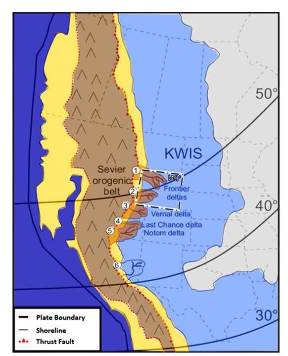
Paleogeography of the Cretaceous Western Interior Seaway (KWIS) during the late Cenomanian and the general position of major delta systems (after Williams & Stelck 1975; Gardner 1995; Blakey 2009). Depocenter ages: 1) Upr. Cenomanian-Lwr. Turonian; 2) Lwr.-Mid. Turonian; 3) Mid-Upr. Turonian; 4) Upr. Turonian; 5) Upr. Turonian; 6) Upr. Turonian-Mid. Coniacian Delta nomenclature after Bhattacharya & Tye (2004); Garrison (2004). Paleolatitude after Irving (1979)
Image: After Clark, C.K., 2010, Stratigraphy, Sedimentology, and Ichnology of the Upper Cretaceous Frontier Formation in the Alkali Anticline Region, Bighorn County, Wyoming: M.S. Thesis, University of Nebraska at Lincoln, Fig. 1, p. 4.
Image: After Clark, C.K., 2010, Stratigraphy, Sedimentology, and Ichnology of the Upper Cretaceous Frontier Formation in the Alkali Anticline Region, Bighorn County, Wyoming: M.S. Thesis, University of Nebraska at Lincoln, Fig. 1, p. 4.
The Frontier at the Thermopolis Anticline consists of four to nine fine-grained sandstone units with interbedded shales. Bentonite beds consisting of clay derived from volcanic ash occur throughout the formation and make excellent subsurface time markers for correlation. Ammonite and pelecypod shells in the lower part of the Cody Shale and the upper part of the Frontier Sandstone provide a local source for calcium carbonate cement.
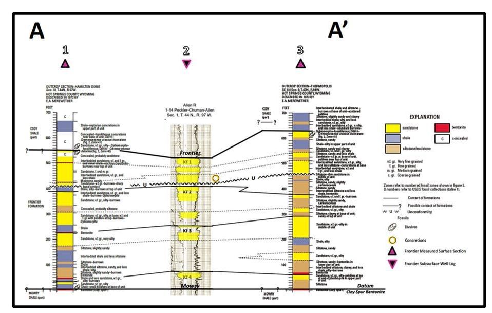
Surface to subsurface correlation of the Late Cretaceous Frontier Formation. Locations shown on first area image and on the thickness map below.
Image: After Merewether, E.A., Cobban, W.A. and Tillman, R.W., 2009, Outcrops, Fossils, Geophysical Logs, and Tectonic Interpretations of the Upper Cretaceous Frontier Formation and Contiguous Strata in the Bighorn Basin, Wyoming and Montana: U.S. Geological Survey Scientific Investigations Report 2009–5256, Fig. 13, p. 20-21; https://pubs.usgs.gov/sir/2009/5256/ ; Well log from Wyoming Oil and Gas Conservation Commission http://wogcc.state.wy.us/legacywogcce.cfm
Image: After Merewether, E.A., Cobban, W.A. and Tillman, R.W., 2009, Outcrops, Fossils, Geophysical Logs, and Tectonic Interpretations of the Upper Cretaceous Frontier Formation and Contiguous Strata in the Bighorn Basin, Wyoming and Montana: U.S. Geological Survey Scientific Investigations Report 2009–5256, Fig. 13, p. 20-21; https://pubs.usgs.gov/sir/2009/5256/ ; Well log from Wyoming Oil and Gas Conservation Commission http://wogcc.state.wy.us/legacywogcce.cfm
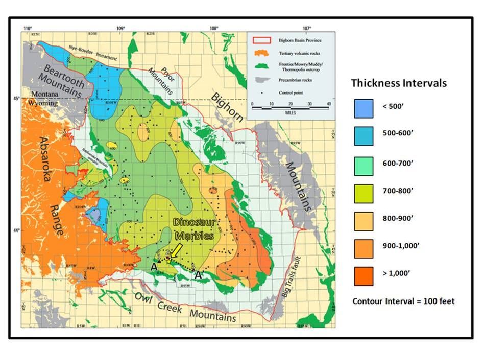
Frontier Formation Thickness Map. Location: yellow star: Dinosaur Marbles concretion field; point-up triangles: Frontier Formation measured section; point-down triangle: Frontier Formation well log; dashed line: stratigraphic cross section A-A’.
Image: After Finn, T.A., Kirschbaum, M.A., Roberts, S.B., Condon, S.M., Roberts, L.N.R. and Johnson, R.C., 2010, Cretaceous–Tertiary Composite Total Petroleum System (503402), Bighorn Basin, Wyoming and Montana: Chapter 3 of Petroleum Systems and Geologic Assessment of Oil and Gas in the Bighorn Basin Province, Wyoming and Montana, U.S. Geological Survey Digital Data Series DDS–69–V, Fig. 10, p. 15;
https://pubs.usgs.gov/dds/dds-069/dds-069-v/REPORTS/69_V_CH_3.pdf
The Frontier Formation is an important hydrocarbon reservoir throughout Wyoming. These reservoir sands have produced over 90 million barrels of oil and 664 billion cubic feet of gas (Finn et al., 2010) within the Bighorn Basin. Frontier production was reported from 40 oil and gas fields in the basin. It was often one of the first productive horizons discovered at these fields. Oil and gas found in the Frontier Formation began generation 63 million years ago, with peak generation 50 million years ago.
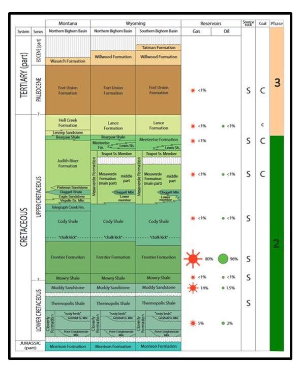
Stratigraphic chart showing Cretaceous and Tertiary reservoir production percentages and source rocks within the Bighorn Basin. The source rocks in the Cody, Mesaverde, Meeteetse and Fort Union are poor quality and have not generated much hydrocarbons. Most of the Frontier oil and gas was sourced from the adjacent Mowry Shale. The Cretaceous and Tertiary reservoirs have produced about 4 percent of cumulative oil and 50 percent of cumulative gas in the basin. Most of the oil in the basin has been produced from the older Phosphoria, Tensleep and Madison.
Image: After Finn, T.A., Kirschbaum, M.A., Roberts, S.B., Condon, S.M., Roberts, L.N.R. and Johnson, R.C., 2010, Cretaceous–Tertiary Composite Total Petroleum System (503402), Bighorn Basin, Wyoming and Montana: Chapter 3 of Petroleum Systems and Geologic Assessment of Oil and Gas in the Bighorn Basin Province, Wyoming and Montana, U.S. Geological Survey Digital Data Series DDS–69–V, Fig. 7, p. 10;
https://pubs.usgs.gov/dds/dds-069/dds-069-v/REPORTS/69_V_CH_3.pdf
Concretions, within the Frontier Formation and stratigraphically equivalent units, occur in many places throughout the Rocky Mountains and Great Plains. They are often developed as tourist stops. Here on the north nose of the Thermopolis Anticline is an undeveloped geologic site. The “marbles” still lie where the dinosaurs left them.

Frontier Formation concretions, Thermopolis Anticline.
Images: Fisher, M., 2017
Images: Fisher, M., 2017
What You Will See At Dinosaur Marbles
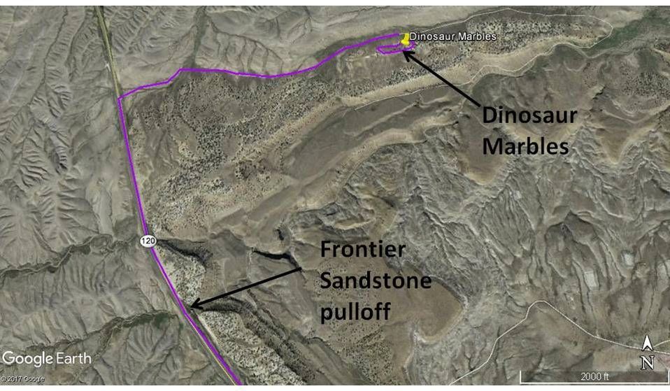
The marble field is interesting and if you like geology, you will also want to check out the concretions embedded in the Frontier Sandstone next to the highway. The dirt road to the marble field requires a high clearance vehicle, but not 4WD on the day we drove it. Do not drive this road if it is wet. If you would rather walk, it is a flat and easy 0.9 miles each way from the highway. The Dinosaur Marble field, the dirt road, and the Frontier Sandstone outcrops near the highway are all on federal BLM and open to the public.
Directions To Dinosaur Marbles
Starting in downtown Thermopolis, head west on WY 120 toward Meeteetse & Cody, 9.0 miles WY 170 on left is road to Anchor Dam, 10.5 miles road to Hot Springs County Airport on left, 15.2 miles pulloff on right for Cretaceous Frontier Sandstone outcrops to see concretion horizon, 16.6 miles turn right on unmarked high clearance dirt road, open and close gate at highway, 17.5 miles park after driving or walking 0.9 miles on dirt road, “Dinosaur Marbles” field is on the slope to your right.
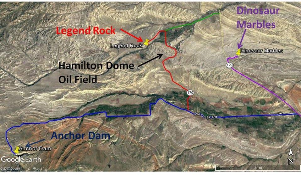
Route map to Anchor Dam (blue), Legend Rock State Petroglyph Site (red), alternate route to Legend Rock (green), and Dinosaur Marbles (purple)
Image by Google Earth
Image by Google Earth
Things To Do At Dinosaur Marbles
In addition to the visit to Dinosaur Marbles, we recommend you visit Anchor Dam and take the side trip to see the petroglyphs at Legend Rock. It is a pretty and peaceful drive to Anchor Dam. There is a small campground on the west side of Anchor Reservoir. There are additional geological sites in the Owl Creek drainage that we have not visited, but are shown in the picture montage at the end.
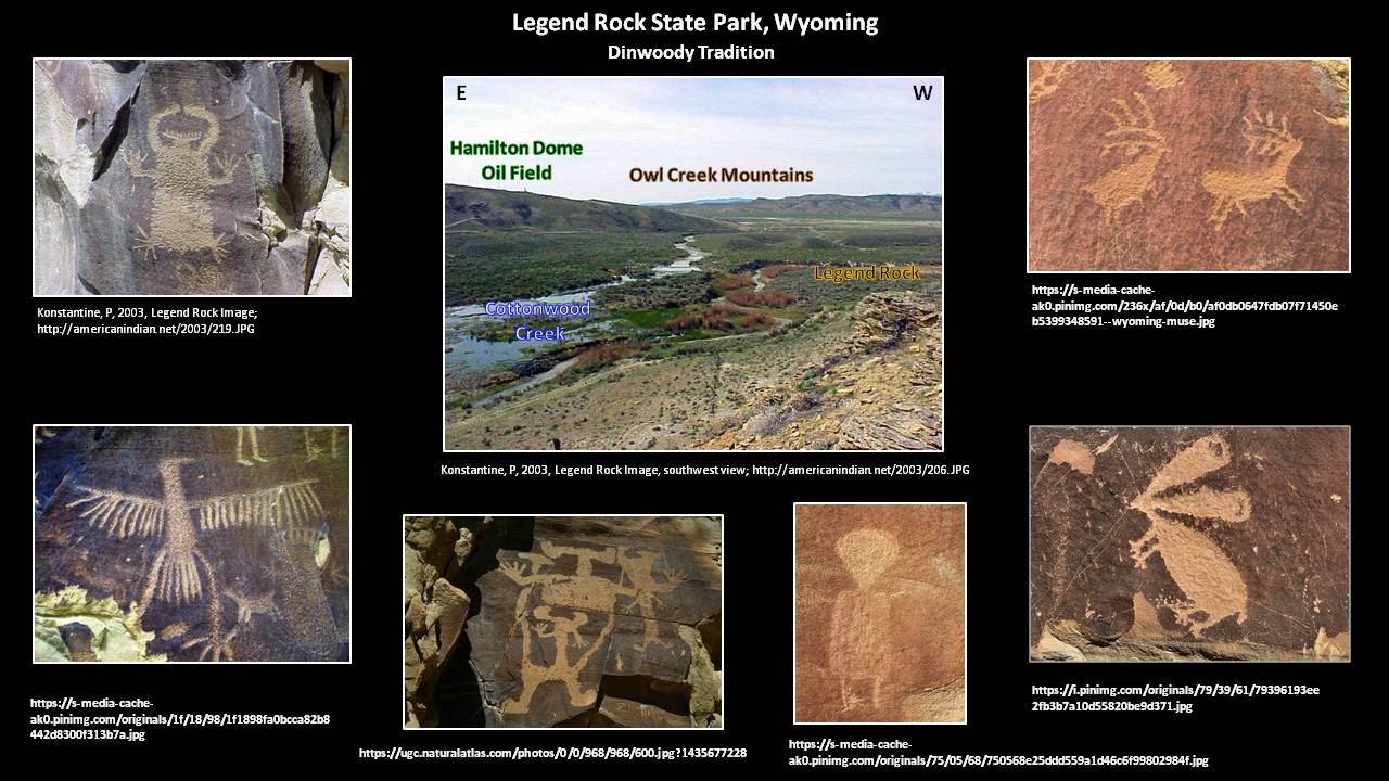
Legend Rock State Petroglyph Site
It has over 300 individual petroglyphs in 92 panels mainly in the Dinwoody tradition. Made during the past several thousand years, the figures include pecked animals, people and people-like features. There is a one-third mile loop trail with 15 numbered petroglyph stops along a cliff of Cretaceous Frontier Sandstone. The trail and cliff is next to Cottonwood Creek with the Hamilton Dome Oil Field just across the creek on the adjacent hill. Legend Rock is open May through September, 8 am to 6 pm. Access from October through April requires a key that can be picked up in Thermopolis at the State Bathhouse.
Directions To Legend Rock State Petroglyph Site From Thermopolis
Starting in downtown Thermopolis, head west on WY 120 toward Meeteetse & Cody, 9.0 miles WY 170 on left is road to Anchor Dam, 10.5 miles road to Hot Springs County Airport on left, 15.2 miles pulloff on right for Cretaceous Frontier Sandstone outcrops to see concretion horizon, 16.6 miles unmarked high clearance dirt road on right is turnoff for Dinosaur Marbles, 20.9 miles turn left on paved Hot Springs County 10, 26.3 miles road forks, take right fork on gravel road, 29.0 miles turn left on Legend Rock Road, 29.5 miles arrive parking lot for Legend Rock State Petroglyph


The material on this page is copyrighted