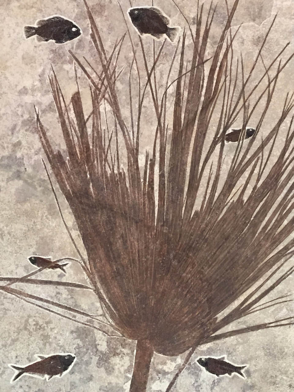
Famous 18 inch mass mortality layer of Fossil Butte Member of Green River Formation, Fossil Basin. Palm frond, Knightia (bottom right and middle), Diplomystus (bottom left corner), Priscacara (top)
Image by Mark Fisher
Image by Mark Fisher
Wow Factor (3 out of 5 stars, if you go on a fossil dig it is five stars):

Geologist Factor (3 out of 5 stars, if you go on a fossil dig it is five stars):

Attraction
Perfectly preserved fish fossils in astounding numbers. This is one of the richest paleontology locations on earth. After visiting Fossil Butte National Monument to see and hear about the geology, you really need to go on a fossil fish dig at a nearby commercial quarry. You will be so engrossed that you will not notice the passage of time, the summer heat or the baking sun. Beware, fossil fever is extremely addictive and similar to gold fever.
Geology of Fossil Butte
Fossil Lake was the smallest of three ancient lakes that existed 52 million years ago during the Eocene in southwest Wyoming, northeast Utah and northwest Colorado (see map below of Green River Lake System). Fossil Lake and Fossil Basin in which it was situated, were elongated north-south and covered about 600 square miles. Location of the basin and of the lake was controlled by the underlying structural geology of the Wyoming Thrust Belt with thrust faults in the area predominantly oriented north-south. Movement on these thrust faults predated the existence of the lakes and the lake sediments are essentially flat and overlie the complexly faulted and folded older rocks. Erosion has dominated this area in the last 3 to 4 million years to generate the butte landscape you see now.

Eocene Green River Lake System with approximate location of Fossil Butte National Monument shown with red square. Green indicates elevated areas during the Eocene.
Image PNG by Meacham, Amanda L., 2017, Unique Preservation of Fossil Ghost Fish in Green River Formation, MS Thesis Loma Linda University, http://scholarsrepository.llu.edu/etd/403/
Image PNG by Meacham, Amanda L., 2017, Unique Preservation of Fossil Ghost Fish in Green River Formation, MS Thesis Loma Linda University, http://scholarsrepository.llu.edu/etd/403/
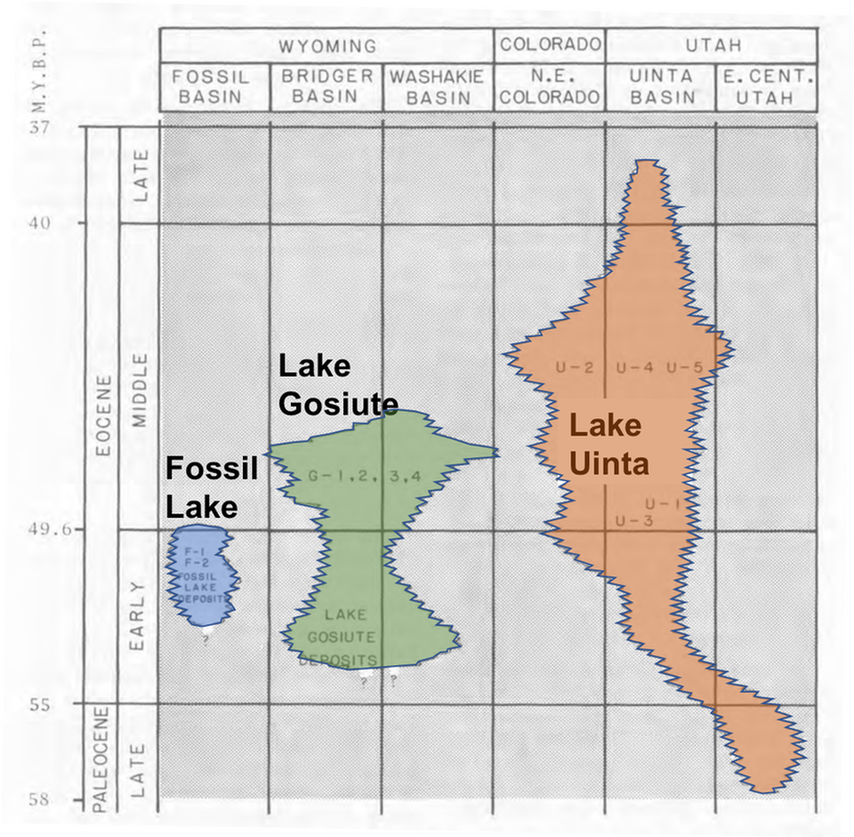
Geographic distribution and time distribution of the three Green River lakes. The vertical scale is millions of years before present. The Fossil Butte Member was deposited about 52 million years before present in the Early Eocene based on dating of a volcanic tuff.
Modified from Lance Grande, 1984, Paleontology of the Green River Formation, with a Review of the Fish Fauna, Geological Survey of Wyoming, Bulletin 63, p 333
http://www.wsgs.wyo.gov/products/wsgs-1984-b-63.pdf (33 MB download)
Modified from Lance Grande, 1984, Paleontology of the Green River Formation, with a Review of the Fish Fauna, Geological Survey of Wyoming, Bulletin 63, p 333
http://www.wsgs.wyo.gov/products/wsgs-1984-b-63.pdf (33 MB download)
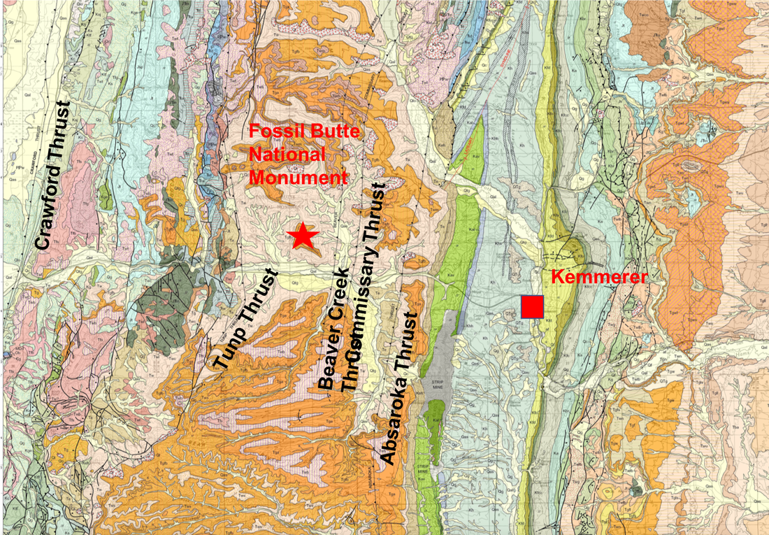
Geologic Map of Kemmerer Quadrangle in Lincoln, Uinta, and Sweetwater Counties, Wyoming, oranges, pinks and beige are Tertiary rocks, the greens are Cretaceous rocks. Faults are shown with thin black lines.
Image by M’Gonigle and Dover, 2004, Wyoming State Geological Survey Open File Report 04-7
http://sales.wsgs.wyo.gov/geologic-map-of-the-kemmerer-30-x-60-quadrangle-lincoln-uinta-and-sweetwater-counties-wyoming-wsgs-2004
Image by M’Gonigle and Dover, 2004, Wyoming State Geological Survey Open File Report 04-7
http://sales.wsgs.wyo.gov/geologic-map-of-the-kemmerer-30-x-60-quadrangle-lincoln-uinta-and-sweetwater-counties-wyoming-wsgs-2004
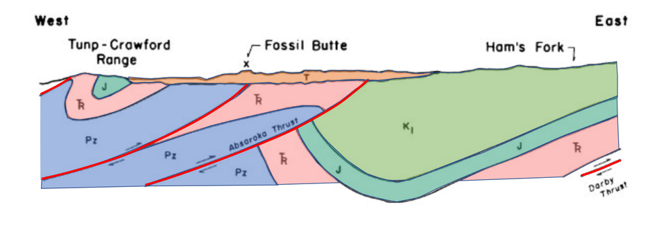
Simplified west to east structural cross section through present-day Fossil Basin. Thrust faults are shown in red, the Paleozoics (Pz) in blue, the Triassic (Tr) in pink, the Jurassic (J) in dark green, the Cretaceous (K) in light green and the Tertiary (T) in light brown. The Fossil Butte Member of the Green River Formation is part of the Tertiary sediments, a thin flat veneer shown capping the complex deep geology.
Modified from McGrew & Casilliano, 1975, The Geologic History of Fossil Butte National Monument and Fossil Basin, National Park Service occasional paper, no. 3 p. 37
https://www.nps.gov/parkhistory/online_books/fobu/contents.htm
Modified from McGrew & Casilliano, 1975, The Geologic History of Fossil Butte National Monument and Fossil Basin, National Park Service occasional paper, no. 3 p. 37
https://www.nps.gov/parkhistory/online_books/fobu/contents.htm
Stratigraphy of Fossil Butte
The river and floodplain sediments deposited along the edge of Fossil Lake became sandstones, siltstones and shales of the Wasatch Formation. Into the lake were deposited clay, sand, silt, carbonate, salts and organic matter that became rocks of the Green River Formation (see stratigraphic column below). The lake deposits are about 400 feet thick and have been divided into three members, the Road Hollow Member at the base, Fossil Butte Member in the middle and the Angelo Member at the top. Fresh water dominated the lake during deposition of the Road Hollow and Fossil Butte Members, whereas hypersalinity dominated deposition of the Angelo Member.
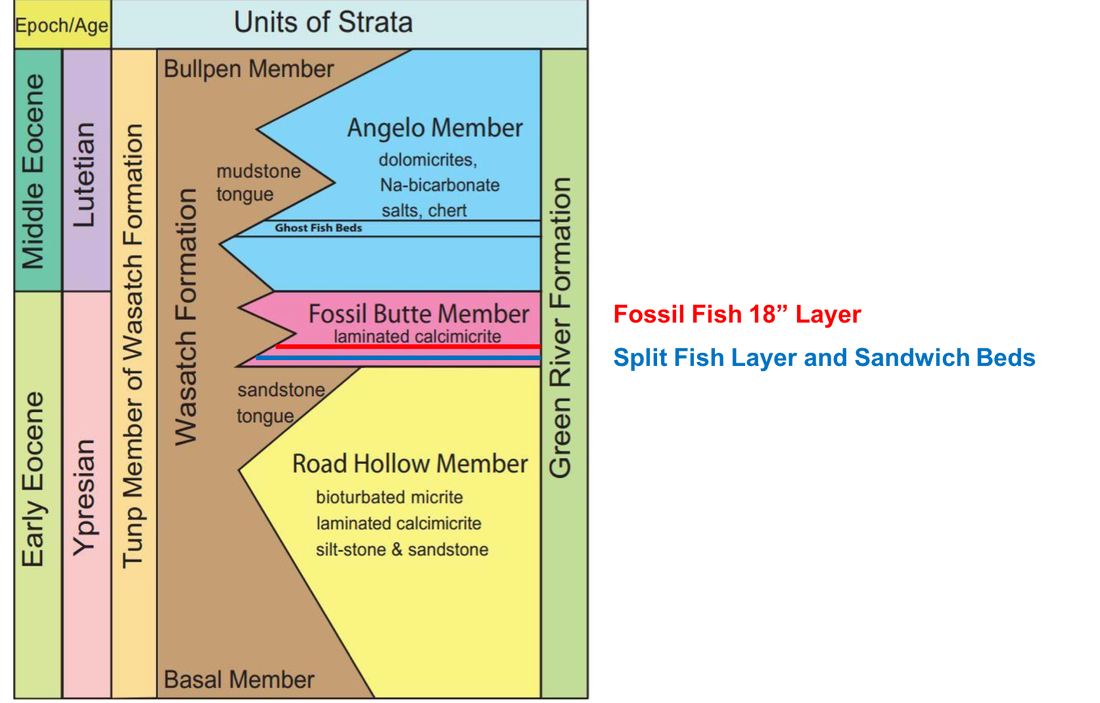
Stratigraphic column for Fossil Butte Area. Famous fossil fish layers are in the Fossil Butte Member of the Green River Formation. Quarries target the “18 inch layer” equivalent to Grande & Buchheim (1994) F-1 localities marked by red line and the “Split Fish Layer” and “Sandwich Beds” equivalent to Grande & Buchheim (1994) F-2 localities marked by blue line.
Modified from Meacham, Amanda L., 2017, Unique Preservation of Fossil Ghost Fish in Green River Formation, MS Thesis Loma Linda University, http://scholarsrepository.llu.edu/etd/403/
Modified from Meacham, Amanda L., 2017, Unique Preservation of Fossil Ghost Fish in Green River Formation, MS Thesis Loma Linda University, http://scholarsrepository.llu.edu/etd/403/
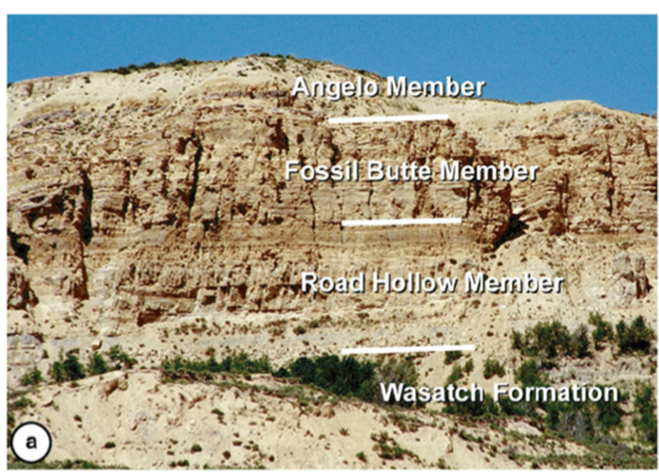
Contacts between the members of Green River Formation and Wasatch Formation at Fossil Butte National Monument
Image by Buchheim, Biaggi and Cushman, 2015, Stratigraphy and Interbasinal Correlations Between Fossil and the Green River Basin, Wyoming, in Stratigraphy and Paleolimnology of the Green River Formation, Western USA
https://www.researchgate.net/publication/286256062_Stratigraphy_and_Interbasinal_Correlations_Between_Fossil_and_the_Green_River_Basin_Wyoming
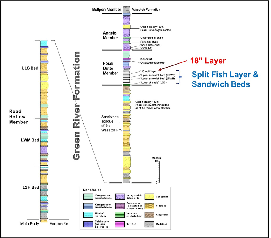
Composite stratigraphic column of Green River Formation in Fossil Basin
Image by Buchheim, Biaggi and Cushman, 2015, Stratigraphy and Interbasinal Correlations Between Fossil and the Green River Basin, Wyoming, in Stratigraphy and Paleolimnology of the Green River Formation, Western USA
https://www.researchgate.net/publication/286256062_Stratigraphy_and_Interbasinal_Correlations_Between_Fossil_and_the_Green_River_Basin_Wyoming
The plant and animals that lived in and around Fossil Lake included fish, amphibians, crocodiles, turtles, birds, ostracods, gastropods, bivalves, insects and a variety of plants and mammals. During the Eocene, the latitude of Wyoming was similar to today, but the climate was moist temperate to subtropical. The presence of crocodiles suggests a constant, warm temperature. Lowlands and floodplains surrounded the lake with palms, cat tails, sycamores, maples and oaks. Upland forests grew on the surrounding hills and mountains
.
The organic ooze at the bottom of Fossil Lake was composed of phytoplankton, blue-green algae, bacteria, zooplankton, and some pollen and spores. Burial and compaction converted the organic matter into a precursor to oil called kerogen.
Layers deposited in the lake center (famous 18 inch fossil fish layer) consist of finely laminated limestone called micrite. The color is light buff to light gray with dark brown laminae composed of kerogen. Each lamina may represent the deposition of an annual or even a seasonal layer of sediment. An annual lamina is called a varve. Thus, the fossil-rich intervals like the 18” layer and split fish layer may only represent a few hundred years to a few thousand years of lake deposition. Fossil fish are found in both kerogen-rich and kerogen-poor laminated micrite (limestone). They are not found in the lake sediments that consist of dolomites that probably represent hypersaline deposition.
Sediments deposited near the lake margin were more oxygen-rich and more disturbed by bottom dwelling burrowers and scavengers that dispersed and broke the fish bones. The water near the lake shore was less saline and less alkaline. Bottom dwellers common in the near-shore environments include gastropods, bivalves, shrimp, crawfish, and stingrays. Because these near-shore sediments were more burrowed, they tend to be organic-poor and less laminated.
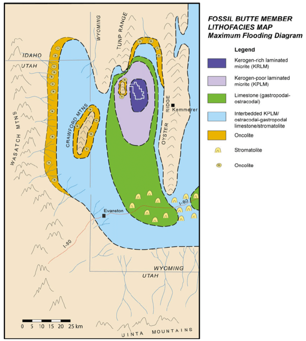
Paleogeography and rock type distribution of the Fossil Butte Member during time of maximum lake extent when Fossil Lake and Lake Gosiute were connected. Fossil Butte National Monument is shown in a white outline within the area dominated by organic-rich laminated limestone deposition (dark blue). The oncolites and stromatolites are layered spherical and columnal structures formed by cyanobacterial growth in shallow water.
Image by Buchheim, Biaggi and Cushman, 2015, Stratigraphy and Interbasinal Correlations Between Fossil and the Green River Basin, Wyoming, in Stratigraphy and Paleolimnology of the Green River Formation, Western USA
https://www.researchgate.net/publication/286256062_Stratigraphy_and_Interbasinal_Correlations_Between_Fossil_and_the_Green_River_Basin_Wyoming
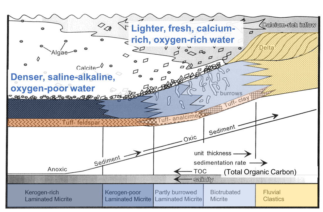
Fossil Basin depositional model has increasing total organic carbon (TOC or kerogen) toward the lake center, increasing salinity in deeper water and in lake center, decrease in oxygen in deeper water and in lake center sediments, increase in oxygen toward shore in water and sediments with more burrows (bioturbation), increase of bed thickness and number of laminae toward shore, increase of sand, silt and clay toward shore.
Modified from Buchheim, 1994, Paleoenvironments, lithofacies and varves of the Fossil Butte Member of the Eocene Green River Formation, Southwestern Wyoming, in Contributions to Geology, U of Wyoming, v 30 no 1, p. 3-14
https://www.researchgate.net/profile/Paul_Buchheim2/publication/275564804_Paleoenvironments_lithofacies_and_varves_of_the_Fossil_Butte_Member_of_the_Eocene_Green_River_Formation_southwestern_Wyoming/links/5698028808aea2d74375db4f/Paleoenvironments-lithofacies-and-varves-of-the-Fossil-Butte-Member-of-the-Eocene-Green-River-Formation-southwestern-Wyoming.pdf
More sediment was deposited near the lake margin. The laminae thicken from lake center to lake margin and become more numerous near the lake margin.
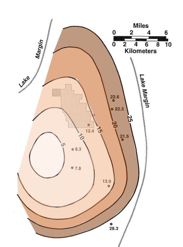
Thickness map in centimeters of Lower Sandwich Bed of Fossil Butte Member of Green River Formation. Map shows increasing bed thickness from lake center toward lake margin. Fossil Butte Monument shown in light gray.
Modified from Buchheim, 1994, Paleoenvironments, lithofacies and varves of the Fossil Butte Member of the Eocene Green River Formation, Southwestern Wyoming, in Contributions to Geology, U of Wyoming, v 30 no 1, p. 3-14
https://www.researchgate.net/profile/Paul_Buchheim2/publication/275564804_Paleoenvironments_lithofacies_and_varves_of_the_Fossil_Butte_Member_of_the_Eocene_Green_River_Formation_southwestern_Wyoming/links/5698028808aea2d74375db4f/Paleoenvironments-lithofacies-and-varves-of-the-Fossil-Butte-Member-of-the-Eocene-Green-River-Formation-southwestern-Wyoming.pdf
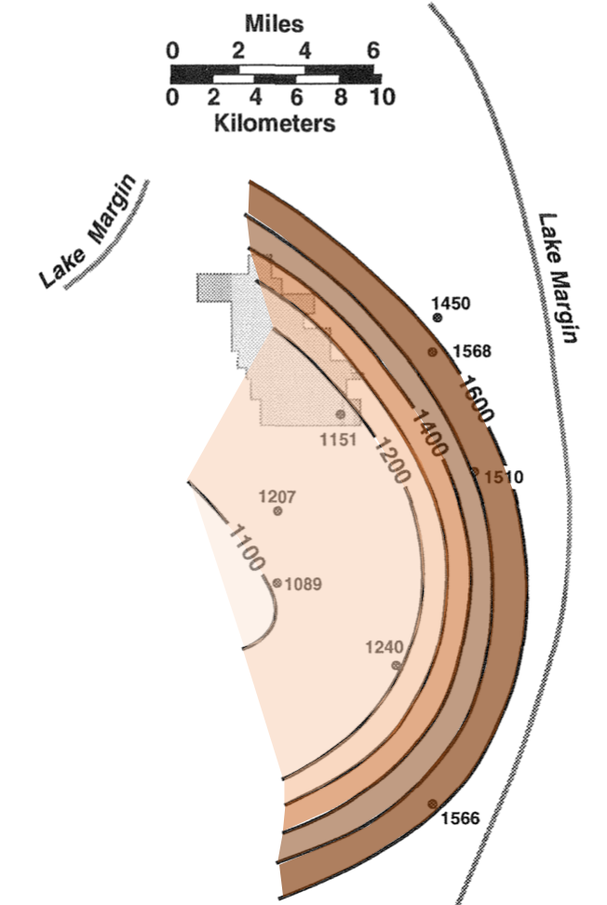
Map of number of laminae in Lower Sandwich Bed shows increase from lake center toward basin margin. Fossil Butte Monument shown in light gray.
Modified from Buchheim, 1994, Paleoenvironments, lithofacies and varves of the Fossil Butte Member of the Eocene Green River Formation, Southwestern Wyoming, in Contributions to Geology, U of Wyoming, v 30 no 1, p. 3-14
https://www.researchgate.net/profile/Paul_Buchheim2/publication/275564804_Paleoenvironments_lithofacies_and_varves_of_the_Fossil_Butte_Member_of_the_Eocene_Green_River_Formation_southwestern_Wyoming/links/5698028808aea2d74375db4f/Paleoenvironments-lithofacies-and-varves-of-the-Fossil-Butte-Member-of-the-Eocene-Green-River-Formation-southwestern-Wyoming.pdf
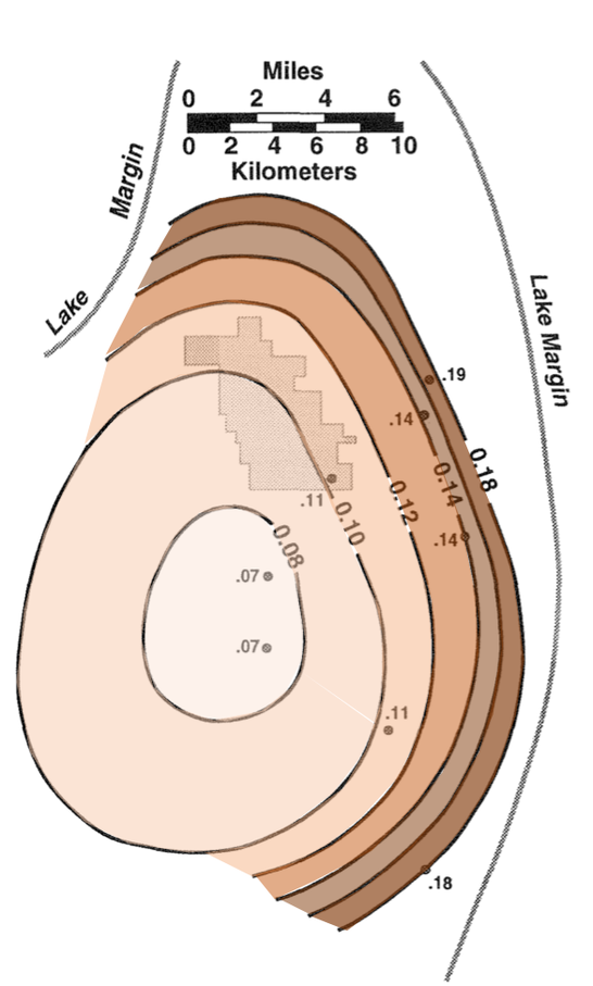
Map of average laminae thickness in Lower Sandwich Bed (millimeters) shows increase from lake center toward basin margin. Fossil Butte National Monument shown in light gray.
Modified from Buchheim, 1994, Paleoenvironments, lithofacies and varves of the Fossil Butte Member of the Eocene Green River Formation, Southwestern Wyoming, in Contributions to Geology, U of Wyoming, v 30 no 1, p. 3-14
https://www.researchgate.net/profile/Paul_Buchheim2/publication/275564804_Paleoenvironments_lithofacies_and_varves_of_the_Fossil_Butte_Member_of_the_Eocene_Green_River_Formation_southwestern_Wyoming/links/5698028808aea2d74375db4f/Paleoenvironments-lithofacies-and-varves-of-the-Fossil-Butte-Member-of-the-Eocene-Green-River-Formation-southwestern-Wyoming
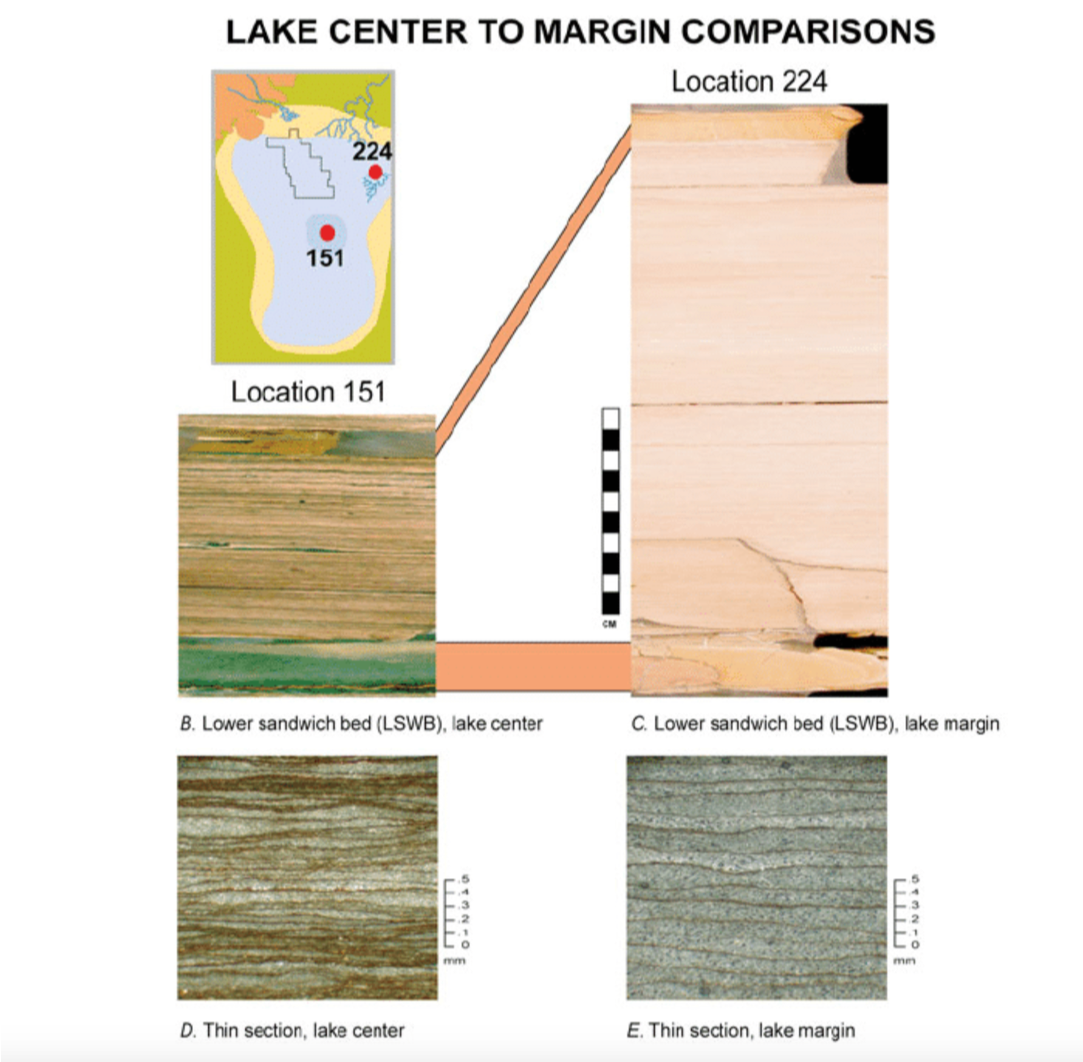
Comparison of lake center rocks on left to lake margin rocks on right. B & C are hand samples with scale bar in centimeters. D & E are thin sections made for microscope work with scale in millimeters. Note organic-rich thinner laminae on the left in lake center and organic-poor thicker laminae on the right in lake margin. Correlation is made by the volcanic ashfall tuffs at top and base of sandwich bed shown in light brown. Rocks are from the Lower Sandwich Bed in the Fossil Butte Member. Map shows sample locations in relation to Fossil Butte National Monument and lake outline.
Image by Buchheim, Biaggi and Cushman, 2015, Stratigraphy and Interbasinal Correlations Between Fossil and the Green River Basin, Wyoming, in Stratigraphy and Paleolimnology of the Green River Formation, Western USA
https://www.researchgate.net/publication/286256062_Stratigraphy_and_Interbasinal_Correlations_Between_Fossil_and_the_Green_River_Basin_Wyoming
Mass Mortality Events
The huge quantity and high quality of fossil preservation at Fossil Butte is extraordinary and a rare occurrence in geologic history. For it to happen, two things have to occur. First, there must be occasional mass mortality events in the lake that killed numerous fish, and second, these mortality events must be rapidly buried without any scavengers and burrowers disturbing the remains. Possible causes of mass mortality at Fossil Lake were: 1) water temperature change, 2) change in water pH, maybe a result of volcanic ashfalls, 3) dry periods that increased water salinity or trapped fish in small pools, 4) algal blooms of blue-green algae that consumed the oxygen in the lake, 5) stratified water turnover bringing saltier oxygen-poor water to the surface, and 6) schools of fish swimming into poisonous bottom waters. The lake was probably chemically or thermally stratified, perhaps only seasonally. The lake center sediments were highly reducing and anoxic with high-organic content. These lake center sediments and their bottom waters were inhospitable for bottom dwellers that would have scavenged on the dead fish.
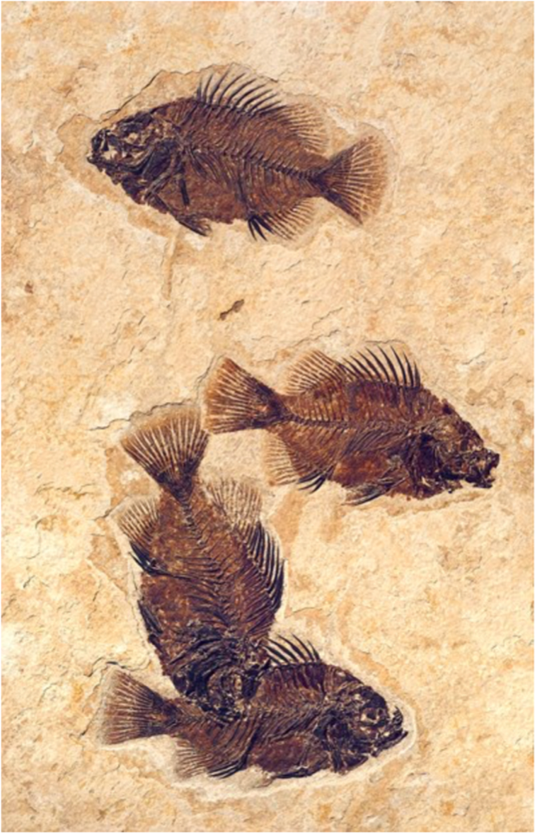
Fossil fish Cockerellites liops killed in mass mortality event. C. liops has a similar shape to today’s sunfish.
Image by National Park Service
https://www.nps.gov/fobu/planyourvisit/visitorcenterexhibits.htm
Image by National Park Service
https://www.nps.gov/fobu/planyourvisit/visitorcenterexhibits.htm
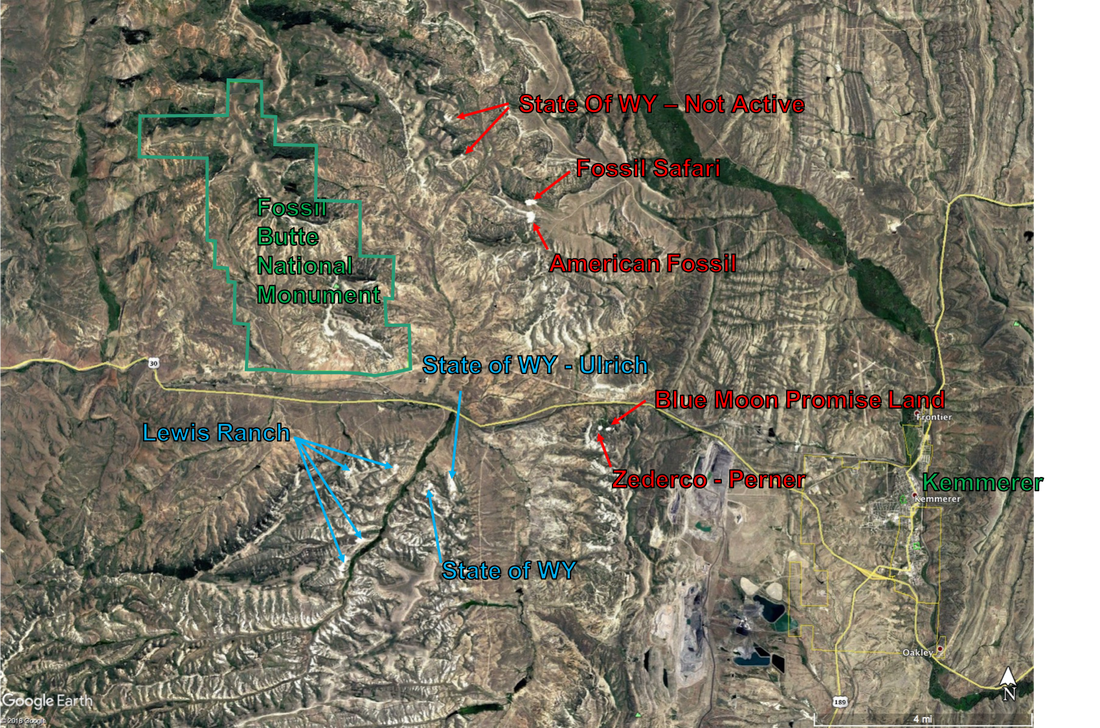
Commercial fish fossil quarries in the Kemmerer area. Blue labeled quarries are lake center and red labeled quarries are near-shore. The quarries labeled Lewis Ranch include multiple operators such as Tynsky, Lindgren, Wyoming Fossils and Green River Stone.
Image by Google Earth
Image by Google Earth
Commercial Fish Fossil Quarry Links
Fossil Basin Promotion Board – Fossil Quarries and Diggings
American Fossil
Blue Moon - Promise Land Fossils
Fossil Safari
Green River Stone Company
Lindgren Fossils LLC
Tynksy's Fossil Fish
Ulrich Fossil Gallery and Quarry
Zederco
American Fossil
Blue Moon - Promise Land Fossils
Fossil Safari
Green River Stone Company
Lindgren Fossils LLC
Tynksy's Fossil Fish
Ulrich Fossil Gallery and Quarry
Zederco
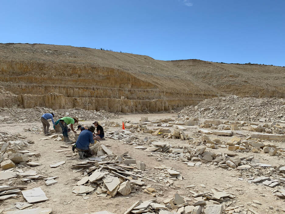
American Fossil quarry with hard working customers engrossed in splitting rock. The famous "18 inch layer" is the dark band at the top of the second bench (about 15 feet above quarry floor). This quarry provides near-shore rock from the "split fish layer/sandwich beds" exposed in the first bench.
Image by Mark Fisher
Image by Mark Fisher
Fossil Butte Geology Links
Fossil Butte National Monument (National Park Service website): https://www.nps.gov/fobu/index.htm
The Geologic History of Fossil Butte National Monument and Fossil Basin (an online short book): https://www.nps.gov/parkhistory/online_books/fobu/index.htm
Paul Buchheim webpage (professor at Loma Linda University) with links to numerous papers on Fossil Lake and the Green River Formation: https://www.researchgate.net/profile/Paul_Buchheim2
Paleontology of the Green River Formation, with a review of the Fish Fauna by Lance Grande, 1984 Geological Survey of Wyoming, Bulletin 63 (33.1 MB pdf with lots of fossil fish pictures): http://www.wsgs.wyo.gov/products/wsgs-1984-b-63.pdf
Big Spring Scenic Backway (a 68 mile scenic drive from Kemmerer to Cokeville, high ground clearance vehicle recommended): http://www.thearmchairexplorer.com/wyoming/big-spring-scenic-backway

The material on this page is copyrighted