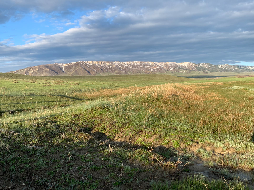
Casper Mountain landscape
Image: Mark Fisher
Image: Mark Fisher
Wow Factor (3 out of 5 stars):
Geologist Factor (3 out of 5 stars):
The earthquakes began in the western part of future Wyoming. They propagated eastward across the state and lasted about 20-30 million years. Massive blocks of basement rock began to be elevated by faults breaking the ground along ancient Precambrian shears and weakness zones. The sedimentary rocks of the Phanerozoic began to fold, fracture and fault. They would erode along with the basement rock, adding their debris to the steams and filling the basins between the mountains in the Cenozoic.
At the surface, in the latest Cretaceous, T-rex and the other dinosaurs felt the vibrations. They walked new paths as the ground began to fold with areas of subsidence and elevation. The Western Interior Seaway continued its retreat to the north and east of the state. Late Cretaceous streams flowed northeastward with abundant clastic sediment eroded from the rising highlands.
This tectonic event is known as the Laramide Orogeny. It created the North American Cordillera extending from Canada to Mexico. An earlier mountain building event, the Sevier Orogeny, also created uplifts extending the entire length of North America. Both orogenies were caused by the plate convergence and subduction at the continents western edge. The shift from a passive to an active margin was due to the breakup of the super-continent Pangea. Subduction began in the Mid-Jurassic, about 140 million years ago.
The Laramide Orogeny began in Wyoming about 70-80 million years ago near the close of the Mesozoic era. The dinosaurs had only about 5-15 million more years to wander across the changing landscape. They had been around over 130 million years and adapted to many changessince the late Triassic. But the bright light that slammed into the Yucatan was going to bring a change to the planet’s dominant species.
In central Wyoming, the Laramide orogeny generated the east-west trending Casper Mountain uplift. The structural grain was inherited from the fabric created by the Precambrian assembly of the Wyoming craton. The Casper Mountain arch connects the Laramie Range with the Casper Arch and the Granite Mountains (aka Sweetwater Arch). The mountain is elevated by the south dipping Casper Mountain fault zone. The exposed basement rocks are part of the central Wyoming greenstone belt that extends from the South Pass area of the Wind River Range eastward across the Sweetwater subprovince.
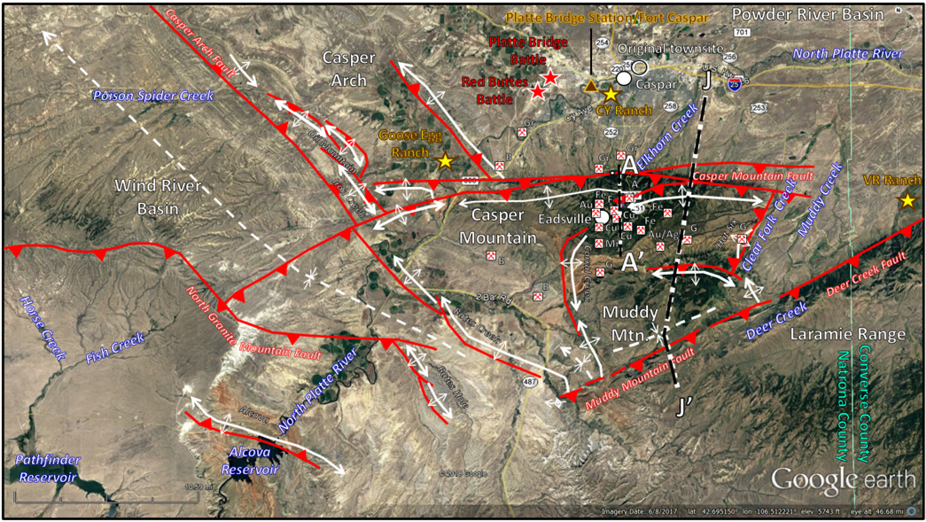
Aerial view of the Casper Mountain Area showing geographic and tectonic features. The Muddy Mountain-Deer Creek Fault has several names use along its segments. Blackstone (1996) interpreted this fault system to mark the limit of the Laramie Range and suggested the name Northern Bounding Fault. Mines indicated by crossed pick and shovel symbol. Commodity and ore codes: A: asbestos (chrysotile), Ag: silver, Au: gold, B: bentonite, Cu: copper F: feldspar, Fe: iron, G: gypsum/anhydrite, Gr: gravel. Thrust and reverse faults indicated by solid red lines with red sawteeth pointing in the direction of fault plane dip. Anticlines shown by solid white lines. Synclines shown by dashed white lines. The location of structural cross sections AA’ and JJ’ are shown by the dashed black and white lines.
Image: Google Earth, Data After Stone, D.S., 2002, Morphology of the Casper Mountain uplift and related, subsidiary structures, central Wyoming: Implications for Laramide kinematics, dynamics, and crustal inheritance: AAPG Bulletin, V. 86, No. 8, Fig. 2, p. 1419; The Diggings website, https://thediggings.com/places/wy0252409406/map
Image: Google Earth, Data After Stone, D.S., 2002, Morphology of the Casper Mountain uplift and related, subsidiary structures, central Wyoming: Implications for Laramide kinematics, dynamics, and crustal inheritance: AAPG Bulletin, V. 86, No. 8, Fig. 2, p. 1419; The Diggings website, https://thediggings.com/places/wy0252409406/map
History
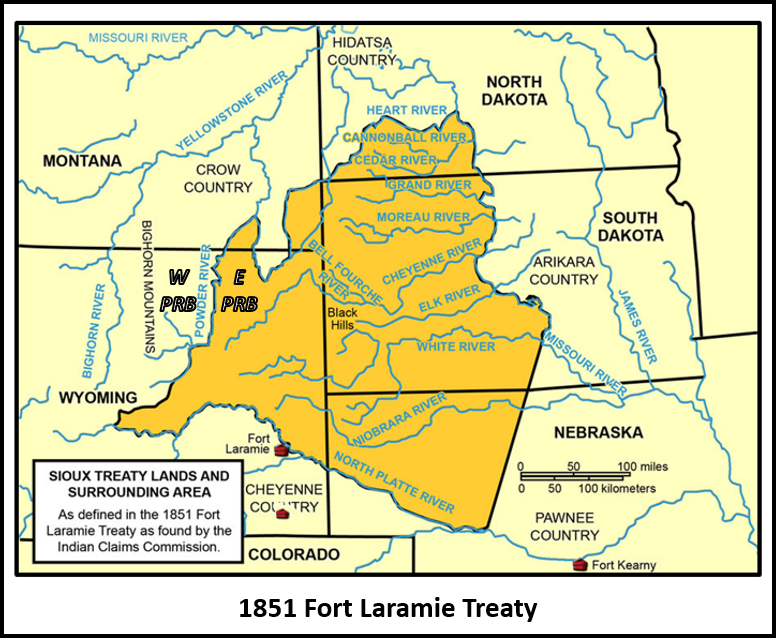
The Powder River Basin was Indian territory. Plains Indian tribes had hunted buffalo on the grasslands for centuries. The U.S. Government gave legal status to their claim with the 1851 Fort Laramie Treaty. The Powder River divided the basin into Crow (west) and Sioux (east) territory. Red Cloud’s War (1866-1868) was a conflict between the Lakota Sioux, Northern Cheyenne, and Northern Arapaho (wanted control of the western Powder River Territory) and the Crow (defending their 1851 treaty rights) and the U.S. Army (defending the three Bozeman Trail forts). The second Fort Laramie Treaty acknowledged the victorious Sioux claim at the expense of the Crow people. While the Sioux accepted a reservation in South Dakota, the U.S. Government recognized the entire Powder River Basin as Sioux unceded hunting territory and space for non-reservation members, and abandoned Forts F.E. Smith, Phil Kearny, and Reno. The U.S. Army and Government, in seeking a non-military end to the war, chose protection of the Transcontinental Railroad over the Bozeman Trail.
Fort Laramie Treaties with the Sioux Nation
Recognized Sioux territory by the 1851 and 1868 Fort Laramie Treaties. Top: 1851 Treaty: W PRB: western Powder River Basin (Crow land), E PRB: eastern Powder River Basin (Sioux land). Bottom: 1868 Treaty at the end of Red Cloud’s War which included the Fetterman (1866), Hayfield (1867), and Wagon Box (1867) fights. Location of battles shown by red X’s. Location of the abandoned Fort Caspar and its replacement at Fort Fetterman, along with the three Bozeman Trail forts (Phil Kearny, Fetterman, and F.E. Smith) are shown by fort symbol. Bozeman Trail indicated by dashed red/black line. Transcontinental railroad shown by black double line track symbol across southern Wyoming.
Image: After State Historical Society of North Dakota, 2018, North Dakota Studies Program;
https://www.ndstudies.gov/gr8/content/unit-iii-waves-development-1861-1920/lesson-4-alliances-and-conflicts/topic-2-sitting-bulls-people/section-3-treaties-fort-laramie-1851-1868
Image: After State Historical Society of North Dakota, 2018, North Dakota Studies Program;
https://www.ndstudies.gov/gr8/content/unit-iii-waves-development-1861-1920/lesson-4-alliances-and-conflicts/topic-2-sitting-bulls-people/section-3-treaties-fort-laramie-1851-1868
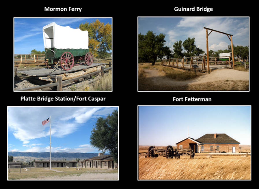
The land adjacent to the North Platte River was reserved as a transportation and communication corridor. The Mormons built a ferry at the “Upper Platte River crossing” near the site of the present day bridge where SW Wyoming Boulevard enters Mills in 1847. Louis Guinard built a trading post and bridge at this location in 1859. Shortly afterward the U.S. Army established Platte Bridge Station (Fort Caspar after 1865) here to protect the emigrant and communication route. The fort was abandoned, and the garrison transferred to the newly commissioned Fort Fetterman in 1867, the year before the Wyoming Territory was established. This new post was at the point where the Bozeman trail veered north from the main North Platte Emigrant trails.
Four reconstructed Casper-area structures important in the Emigrant and U.S. Army years. Besides catering to the emigrants, Guinard’s served as an Overland Stage Coach stop (1859-1862), Pony Express relay station (1860-1961), and a telegraph office (1861).
Images: Mormon Ferry: http://www.fortcasparwyoming.com/fort_caspar_site_history; Guinard Bridge: Highsmith, C.M., 2014, https://www.loc.gov/resource/highsm.34099/; Fort Caspar: http://www.fortcasparwyoming.com/; Fort Fetterman: Grunwald, E., 2014, https://www.flickr.com/photos/ericgrunwald/1182971 0714/in/photostream/.
Images: Mormon Ferry: http://www.fortcasparwyoming.com/fort_caspar_site_history; Guinard Bridge: Highsmith, C.M., 2014, https://www.loc.gov/resource/highsm.34099/; Fort Caspar: http://www.fortcasparwyoming.com/; Fort Fetterman: Grunwald, E., 2014, https://www.flickr.com/photos/ericgrunwald/1182971 0714/in/photostream/.
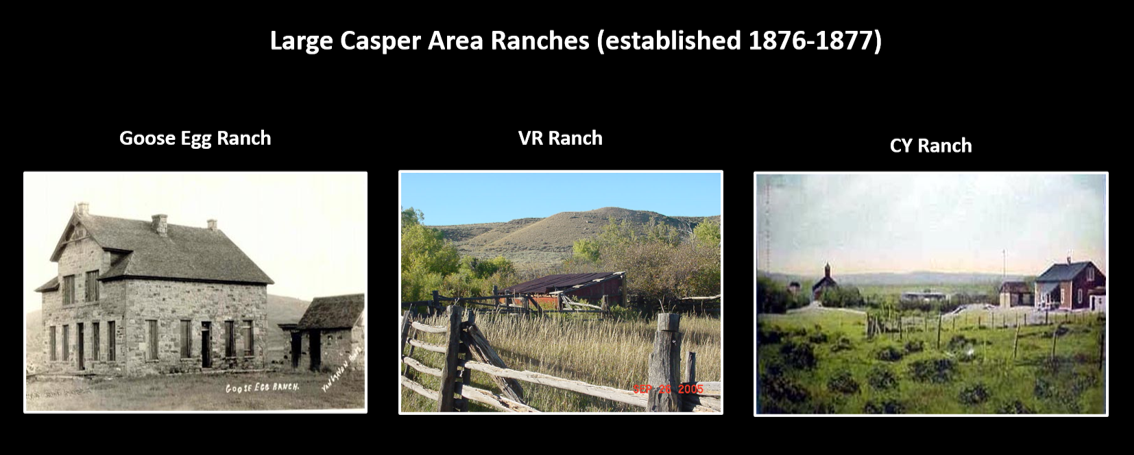
Wyoming’s cattle industry began in the mid-1870s in the open range of the southeastern corner of the Wyoming Territory (east of the Laramie Range and south of the North Platte). It migrated into the Casper area in the late 1870s. Three large cattle operations where established: 1) the Searight brothers Goose Egg Ranch at Bessemer Bend (11 miles west of Casper), 2) Major Frank Wolcott’s VR Ranch on Deer Creek (18 miles southeast of Casper and 11 miles southwest of Glenrock), and 3) J.M. Carey and brother’s CY Ranch (at present day Casper).
Casper aerial location index
Image: Google Earth
Image: Google Earth
Three large cattle ranches established in the Casper Mountain area between 1876 and 1877.
Images: Goose Egg: http://www.wyomingtalesandtrails.com/bessemer.html; VR:http://www.trueranches.com/operations/ranches/vr-ranch; CY: http://www.wyomingtalesandtrails.com/nplatte3.html.
Images: Goose Egg: http://www.wyomingtalesandtrails.com/bessemer.html; VR:http://www.trueranches.com/operations/ranches/vr-ranch; CY: http://www.wyomingtalesandtrails.com/nplatte3.html.
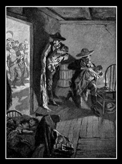
The Goose Egg was made famous by Owen Wister’s novel “The Virginian(1902).” The ranch house above is where the Virginian and Lin McLean performed a prank to ease their mutual jealousy due to rejection by the schoolmarm. They exchanged the blankets on the babies, so parents picked up the wrong baby when the dance ended. The CY operation bought out the Searight’s in 1886 and added the property to the CY Ranch. Locals continued to refer to the property as the Goose Egg and visitors would chip away bits of the original ranch house for mementos over the years. The house continued to deteriorate and was finally demolished in 1951.
The cowboy baby blanket prank at the Goose Egg Ranch barbecue dance.
Image: Wister, O., 2017 Kindle Edition, The Virginian (Illustrated), Fig. on p. 70.
Image: Wister, O., 2017 Kindle Edition, The Virginian (Illustrated), Fig. on p. 70.
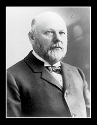
The Carey brothers (Joseph M.and R. Davis) operated three large ranches in the area: 1) the CY in Casper (including the old Goose Egg Ranch), 2) the C lazy Y in Converse County, west of Glenrock, and 3) Careyhurst on Boxelder Creek, the ranch operations headquarters). Besides having been a rancher, J.M. Carey served Wyoming as U.S. Attorney for the territory (1869-1871), Associate Justice of the Wyoming Supreme Court (1871-1876), Mayor of Cheyenne (1881-1885), Territorial Delegate to the U.S. House of Representatives (1885-1890), U.S. Senator (1890-1895), and Wyoming Governor (1911-1915).
Joseph Maull Carey, Wyoming lawyer, rancher, judge, and politician. CY avenue is named after his ranch.
Image: http://www.nndb.com/people/676/000210046/.
Image: http://www.nndb.com/people/676/000210046/.
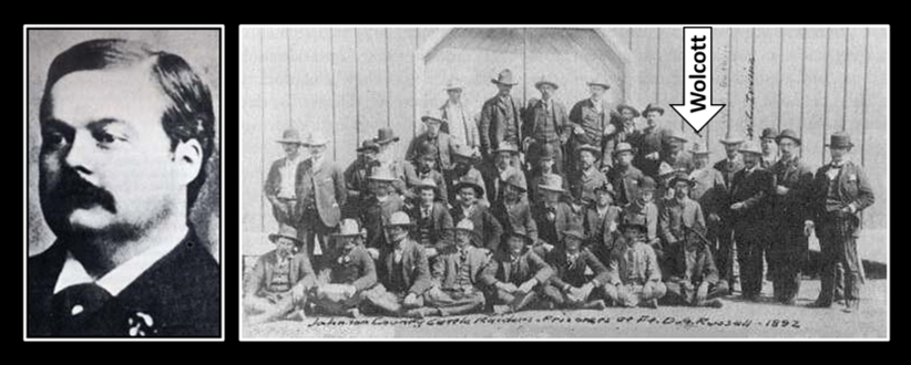
The VR Ranch name stood for “Victoria Regina” in honor of their British investors. Owen Wister spent the summer of 1885 as a guest at the VR. Major Frank Wolcott, the owner, was a model for Wister’s Judge Henry character in The Virginian, a member of the Wyoming Stock Growers Association and a leading figure in the Johnson County War (1889-1893) between cattle barrons (Wolcott and “The Virginian’s” side) and homesteaders and small ranches (the side of the protagonist in Jack Schaefer's 1949 novel Shane). Wolcott’s gang of regulators reportedly murdered and terrorized small ranchers opposed to the open range and the consolidation of ranches. Wyoming’s cattle boom of the 1880’s cemented its reputation as the Cowboy State.
Frank Wolcott: Left: Civil War Private to Major, U.S. Land Office, rancher and member of the Wyoming Stock Growers Association; Right: as a prisoner, with the rest of his Johnson County War regulators at Fort McKinney in 1892.
Image: Left: http://spartacus-educational.com/WWwolcott.htm; Right: http://www.wyomingtalesandtrails.com/johnson3.html.
Image: Left: http://spartacus-educational.com/WWwolcott.htm; Right: http://www.wyomingtalesandtrails.com/johnson3.html.
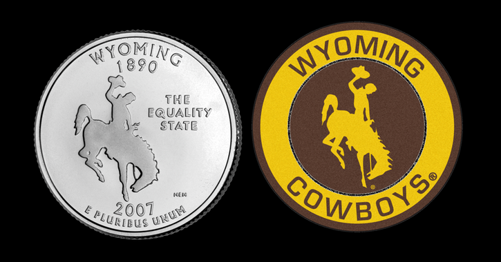
The Wyoming state quarter and University of Wyoming logo.
Image: Coin: U.S. Mint, https://www.usmint.gov/coins/coin-medal-programs/50-state-quarters/wyoming; Patch: http://www.seat.today/wyoming-cowboys-tickets/
Image: Coin: U.S. Mint, https://www.usmint.gov/coins/coin-medal-programs/50-state-quarters/wyoming; Patch: http://www.seat.today/wyoming-cowboys-tickets/
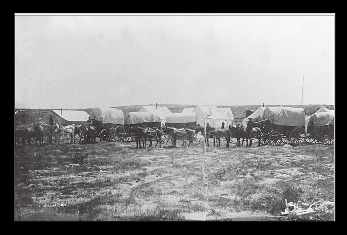
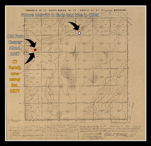
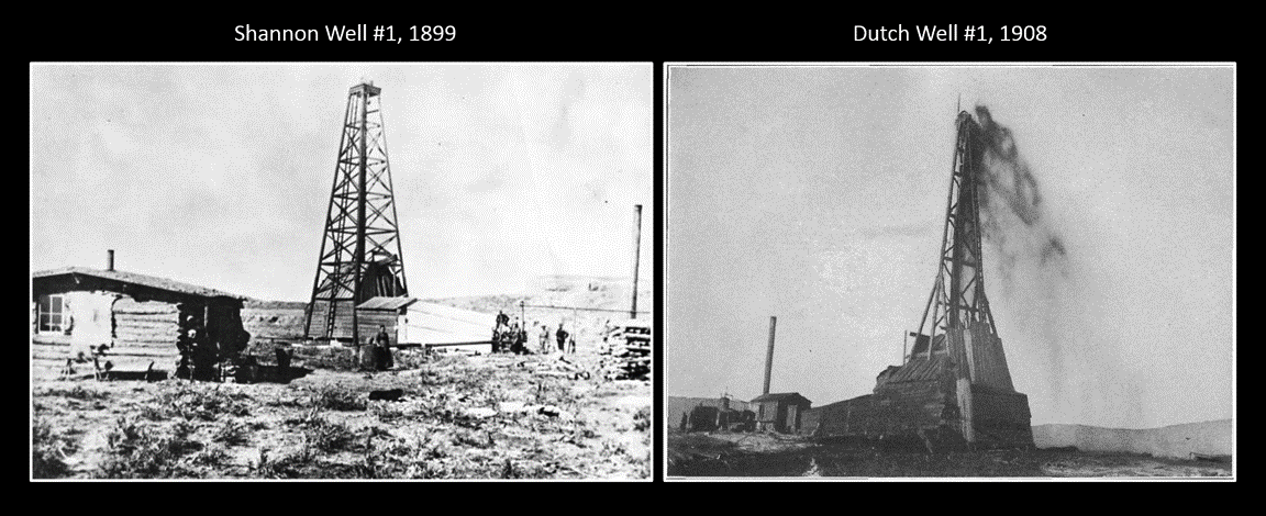
Two men who were camped in the Sandbar area of the North Platte got wind of the approaching railroad line. On June 8, 1888, John Merritt, a Canadian, and C.W. Eads, a prospector and notorious horsethief, pitched a tent at what would become the intersection of McKinley and A street. Others soon joined them and thus Casper was founded. The train arrived on the newly laid track the following week. The modern transportation brought settlers and new businesses focused on the stock raising industry and timber logging on Casper Mountain. The discovery of oil in the Shannon Sandstone (Shannon #1) in 1889, and again in the First Wall Creek Sandstone at Salt Creek (Dutch #1) in 1908 ignited Casper’s first oil boom.
Tent Town Casper near present-day McKinley and A streets in 1888.
Image: Trumbull, C. and Nicolaysen, K., 2013, Images of America: Casper, p. 11.
Image: Trumbull, C. and Nicolaysen, K., 2013, Images of America: Casper, p. 11.
1882 Plat of Township 33 North, Range 79 West, future Casper, Natrona County, Wyoming.
Image: After Owen, W.O., 1882, GLO & BLM Survey Plats & Field Notes;
https://www.wy.blm.gov/cadastral/countyplats/natrona/t33nr79w.pdf
Image: After Owen, W.O., 1882, GLO & BLM Survey Plats & Field Notes;
https://www.wy.blm.gov/cadastral/countyplats/natrona/t33nr79w.pdf
Early Casper area oil wells at Salt Creek Field.
Image: Left: http://trib.com/business/energy/photos-casper-s-oil-boom-years-from-the-early-s/collection_89d444c9-bf3f-5950-a395-0a40226de9e2.html#9; Right: https://en.wikipedia.org/wiki/Salt_Creek_Oil_Field#/media/File:Salt_Creek_Oil_Field_well.jpg
Image: Left: http://trib.com/business/energy/photos-casper-s-oil-boom-years-from-the-early-s/collection_89d444c9-bf3f-5950-a395-0a40226de9e2.html#9; Right: https://en.wikipedia.org/wiki/Salt_Creek_Oil_Field#/media/File:Salt_Creek_Oil_Field_well.jpg
Casper Mountain Geology
Casper Mountain is an asymmetric arch that is 16 miles long with a maximum width of four miles. It rises 3,000 feet above Casper in the North Platte River Valley. The mountain was elevated by the south dipping Casper Mountain fault that has at least 5,000 feet of stratigraphic separation. The uplift is directed mainly northward with some amount of left-lateral slip.
The oldest date obtained from the exposed Precambrian rocks is 2.8 billion years. The older rocks of the Wyoming craton basement are not exposed but underlie the younger Archean outcrops.
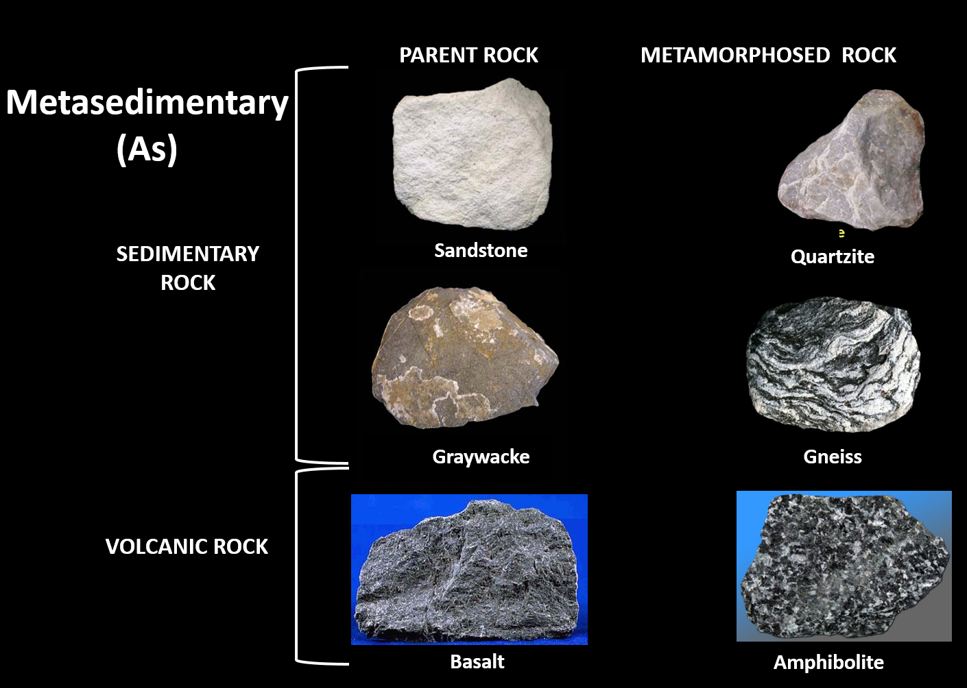
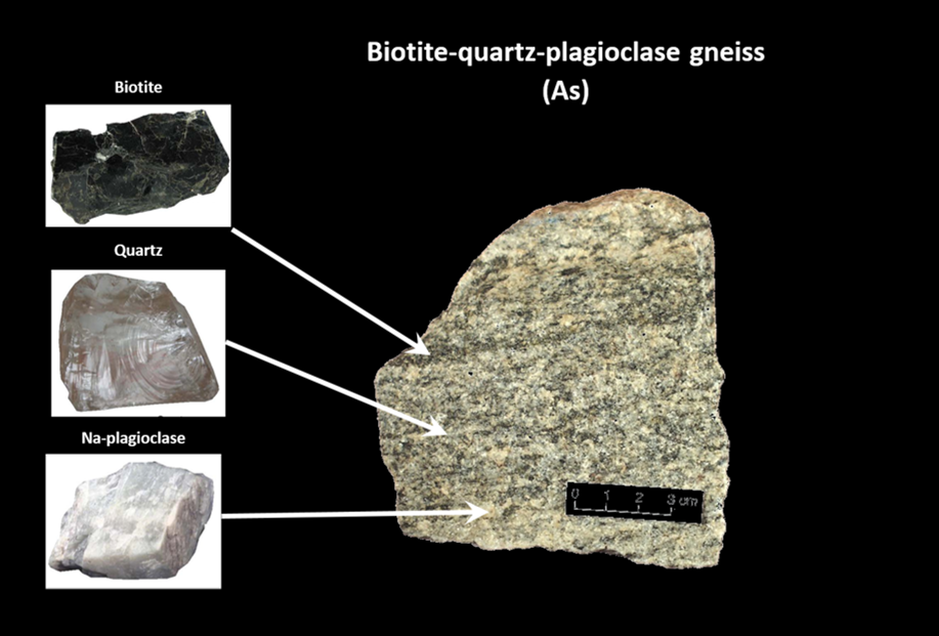
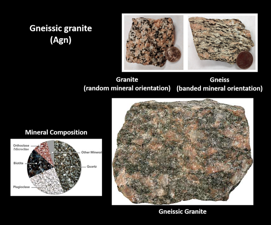
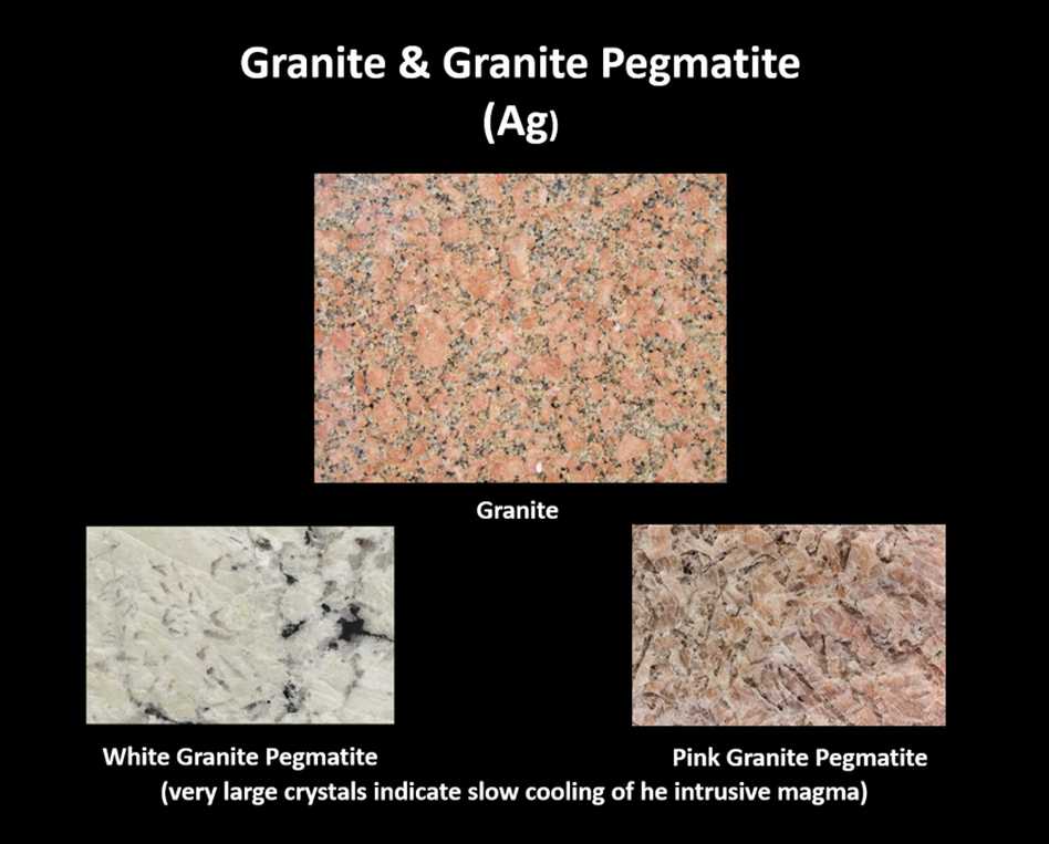
An Archean sedimentary sequence of sandstone and greywacke accumulated in a basin at the margin of the Bighorn-Beartooth subprovince of the juvenile Wyoming Craton. The sedimentary rocks are intruded and interbedded with mafic igneous units. Around 2.7-2.8 billion years ago regional amphibolite-grade metamorphism and deformation occurred (suturing the Sweetwater to the Bighorn-Beartooth subprovince?) that enfolded the greenstone terrane with the granite-gneiss rocks (Agn). Similar rocks in nearby mountains show the same date range for metamorphism. The folding and foliation in the rock are aligned east-northeast and dip to the southeast. This event altered the sandstone to quartzite and the greywacke to gneiss and schist (As). Volcanic layers (basalt?) were altered to amphibolite. Serpentinized mafic rocks (peridotite) intruded within the metasedimentary rock (Asp). Some ultra-mafic rocks intruded the sequence during or after metamorphism. Another metamorphic event occurred in the Proterozoic about 1.7 billion years ago with the intrusion of granite (Ag) between 1.4-1.7 billion years ago that further altered the mineral assemblage and composition to a green schist-grade within the Archean rocks.
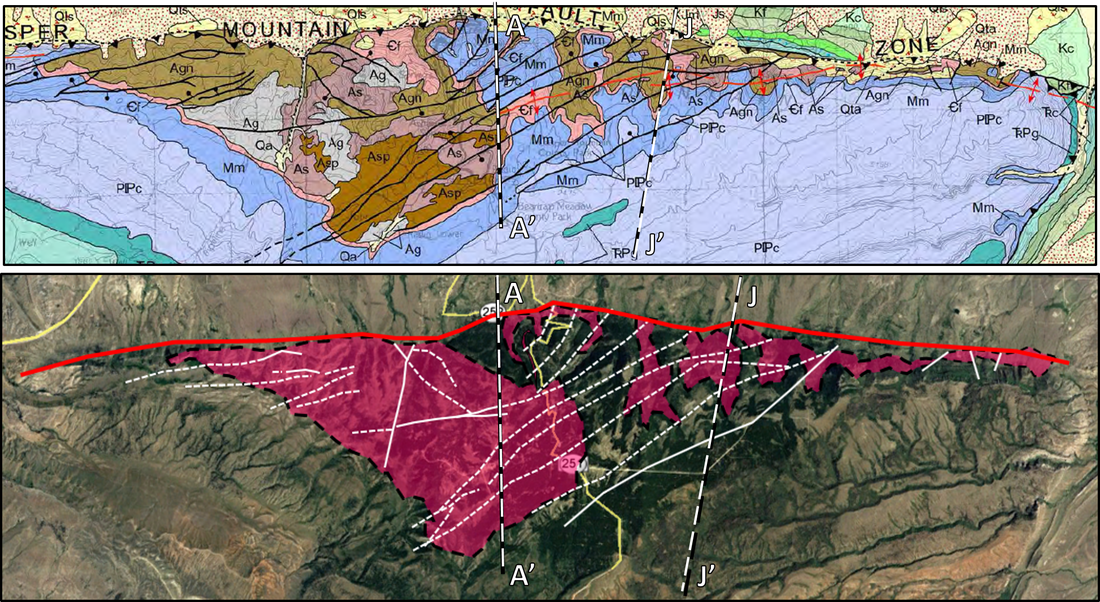
Top: Geologic map of Casper Mountain. Bottom: Aerial image of Precambrian rocks and faulting of Casper Mountain. Formation codes are shown on the stratigraphic column below. Distribution of Precambrian rocks shown by pink color. Faults shown in white lines, dashed where covered. Casper Mountain fault shown by red line. Location of cross sections AA’ and JJ’ shown on both.
Image: Top: After Hunter, John, Ver Ploeg, A.J., and Boyd, C.S., 2005, Geologic map of the Casper 30' x 60' quadrangle, Natrona and Converse counties, Wyoming: Wyoming State Geological Survey Map Series 65, scale 1:100,000, http://www.wsgs.wyo.gov/products/wsgs-2005-ms-65.pdf. Bottom: Google Earth.
Image: Top: After Hunter, John, Ver Ploeg, A.J., and Boyd, C.S., 2005, Geologic map of the Casper 30' x 60' quadrangle, Natrona and Converse counties, Wyoming: Wyoming State Geological Survey Map Series 65, scale 1:100,000, http://www.wsgs.wyo.gov/products/wsgs-2005-ms-65.pdf. Bottom: Google Earth.
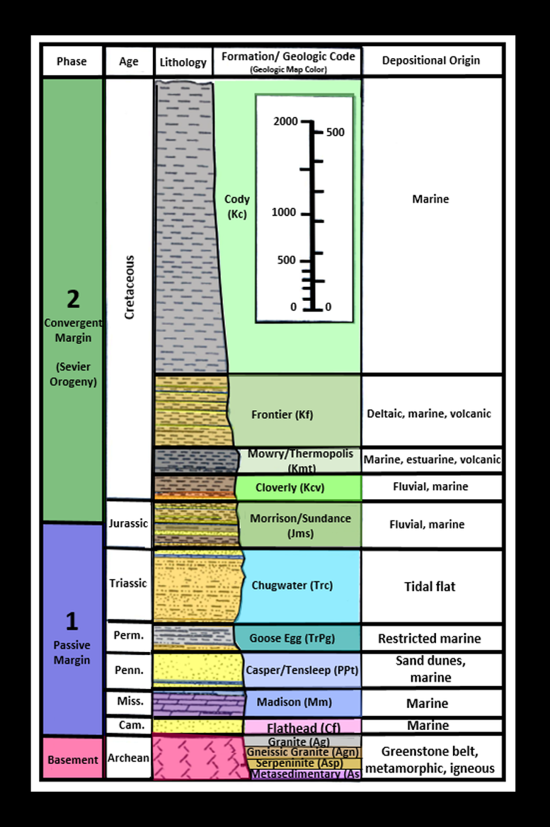
Stratigraphic column for the Casper Mountain area. The fourth column lists the formations, codes and colors used in the geologic map. Quaternary units (those deposited in the last 1.8 million years) are not shown on the stratigraphic column. These surficial deposits include (youngest to oldest) Qa: alluvial, Qls: landslide, Qta: talus, Qac: mixed alluvium and colluvium, Qt: terrace, Qs: windblown sand and Qf: alluvial fan. These deposits were sourced by erosion of the Laramide uplifts and are displayed on the geologic map in various shades of yellow and light tan.
Image: After Stone, D.S., 2002, Morphology of the Casper Mountain uplift and related, subsidiary structures, central Wyoming: Implications for Laramide kinematics, dynamics, and crustal inheritance: AAPG Bulletin, V. 86, No. 8, Fig. 3, p. 1420.
Image: After Stone, D.S., 2002, Morphology of the Casper Mountain uplift and related, subsidiary structures, central Wyoming: Implications for Laramide kinematics, dynamics, and crustal inheritance: AAPG Bulletin, V. 86, No. 8, Fig. 3, p. 1420.
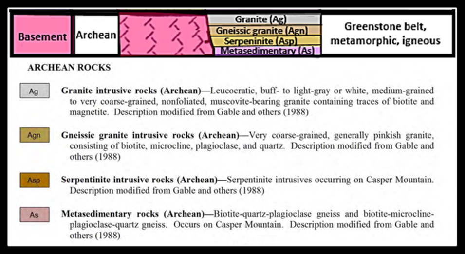
Archean Stratigraphic column for Casper Mountain. Rock images are shown below.
Image: After Stone, D.S., 2002, Morphology of the Casper Mountain uplift and related, subsidiary structures, central Wyoming: Implications for Laramide kinematics, dynamics, and crustal inheritance: AAPG Bulletin, V. 86, No. 8, Fig. 3, p. 1420, and Hunter, John, Ver Ploeg, A.J., and Boyd, C.S., 2005, Geologic map of the Casper 30' x 60' quadrangle, Natrona and Converse counties, Wyoming: Wyoming State Geological Survey Map Series 65, scale 1:100,000, http://sales.wsgs.wyo.gov/geologic-map-of-the-casper-30-x-60-quadrangle-natrona-and-converse-counties-central-wyoming-2005/
Image: After Stone, D.S., 2002, Morphology of the Casper Mountain uplift and related, subsidiary structures, central Wyoming: Implications for Laramide kinematics, dynamics, and crustal inheritance: AAPG Bulletin, V. 86, No. 8, Fig. 3, p. 1420, and Hunter, John, Ver Ploeg, A.J., and Boyd, C.S., 2005, Geologic map of the Casper 30' x 60' quadrangle, Natrona and Converse counties, Wyoming: Wyoming State Geological Survey Map Series 65, scale 1:100,000, http://sales.wsgs.wyo.gov/geologic-map-of-the-casper-30-x-60-quadrangle-natrona-and-converse-counties-central-wyoming-2005/
Archean rock types at Casper Mountain and on cross section below.
Image: As 1: Sedimentary parent and metamorphic daughter rocks: http://gotbooks.miracosta.edu/earth_science/images/sr3.jpgand http://gotbooks.miracosta.edu/earth_science/chapter11.html; Volcanic parent and daughter rocks: https://en.wikipedia.org/wiki/File:BasaltUSGOV.jpg and http://geologycafe.com/gems/chapter10.html;
As 2: Minerals: http://gotbooks.miracosta.edu/earth_science/images/minerals.jpg; Biotite-quartz-plagioclase gneiss: https://www.earth.ox.ac.uk/~oesis/rocks/a98-9.html; Biotite-microcline-plagioclase-quartz gneiss: http://www.sandatlas.org/gneiss; As 3: Minerals: http://gotbooks.miracosta.edu/earth_science/images/minerals.jpgand https://upload.wikimedia.org/wikipedia/commons/e/e6/Microcline-199473.jpg; Asp: Peridotite Types: https://crustal.usgs.gov/projects/CO2_sequestration/index.html#carbonation; Serpentine in peridotite protolith: http://geologycafe.com/images/serpentinite_harzburgite.jpg; Chrysotile asbestos: http://gotbooks.miracosta.edu/earth_science/images/metamorphic_minerals.jpg; Agn: Granite & gneiss: http://opengeology.org/textbook/7-geologic-time/; Compositional Pie Chart:https://www.pinterest.ch/pin/550283648195115976/; Gneissic granite: https://flexiblelearning.auckland.ac.nz/rocks_minerals/rocks/gneiss.html; Ag: Granite: https://en.wikipedia.org/wiki/Granite#/media/File:Fj%C3%A6regranitt3.JPG; White pegmatite: http://www.slipperyrockgazette.net/index.cfm//pageId/3011; Pink pegmatite: http://www.sandatlas.org/pegmatite/.
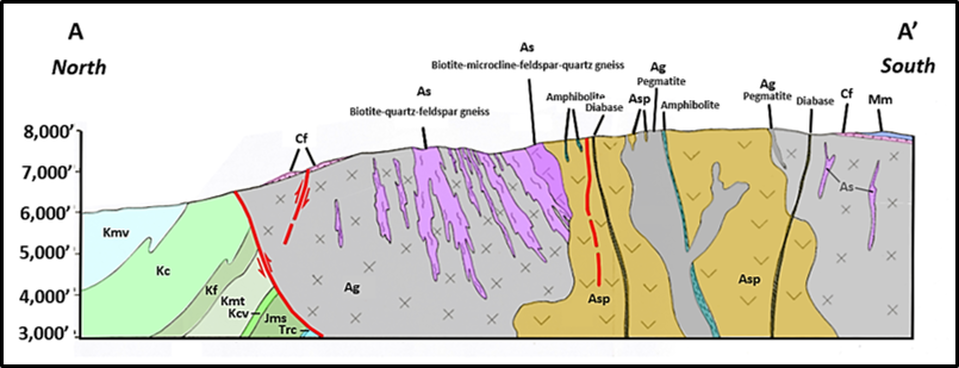
Central Casper Mountain cross section AA’ showing deformed and metamorphosed greenstone terrane. Cross cutting relationships show the following sequence for the individual units: 1) Sedimentary and volcanic parent rocks were folded and metamorphosed into foliated gneiss (As, graywacke protolith), quartzite (As, sandstone protolith) and ampbiolite (silver green layers; 2) intrusion of ultramafic rocks (Asp, serpentine); 3) intrusion of granitic pluton (Ag); 4) intrusion of granite pegmatites (Ag, darker grey colored); 5) intrusion of diabase dikes. Structurally the Precambrian folds and foliation dip to the south. The Precambrian core is thrust upward to the north by the Laramide Casper Mountain fault. Phanerozoic rocks in the footwall of the fault are dipping northward.
Image: Modified from Burford, A.E., Corbett, R.G., Franks, P.C., Friberg, L.M., Lorson, R.C., Marsek, F.A., Nanna, R.F., Schumacher, J.C., Wymer, R.E., 1979, Precambrian Complex of Casper Mountain, Wyoming: Wyoming Geological Association, Earth Science Bulletin, Vol. 12, No. 2, Plate 1.Additional data from: Hunter, John, Ver Ploeg, A.J., and Boyd, C.S., 2005, Geologic map of the Casper 30' x 60' quadrangle, Natrona and Converse counties, Wyoming: Wyoming State Geological Survey Map Series 65, scale 1:100,000.
Image: Modified from Burford, A.E., Corbett, R.G., Franks, P.C., Friberg, L.M., Lorson, R.C., Marsek, F.A., Nanna, R.F., Schumacher, J.C., Wymer, R.E., 1979, Precambrian Complex of Casper Mountain, Wyoming: Wyoming Geological Association, Earth Science Bulletin, Vol. 12, No. 2, Plate 1.Additional data from: Hunter, John, Ver Ploeg, A.J., and Boyd, C.S., 2005, Geologic map of the Casper 30' x 60' quadrangle, Natrona and Converse counties, Wyoming: Wyoming State Geological Survey Map Series 65, scale 1:100,000.
Casper Mountain area structural cross section. The asymmetry of the structure is shown by gentle dips in the Phanerozoic section on the south flank and steeper dips to the north into the Powder River Basin.
Image: After Blackstone, D.L., Jr. 1996, Structural Geology of the Laramie Mountains, Southeastern Wyoming and Northeastern Colorado: Wyoming State Geological Survey Report of Investigations No. 51, Fig. 17, p. 18-19, http://www.wsgs.wyo.gov/products/wsgs-1996-ri-51.pdf
Image: After Blackstone, D.L., Jr. 1996, Structural Geology of the Laramie Mountains, Southeastern Wyoming and Northeastern Colorado: Wyoming State Geological Survey Report of Investigations No. 51, Fig. 17, p. 18-19, http://www.wsgs.wyo.gov/products/wsgs-1996-ri-51.pdf
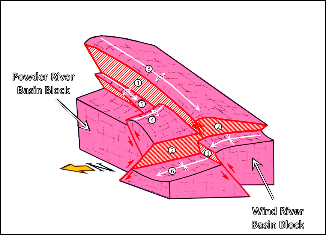
Southeast view of 3D diagram of the fault intersection of Casper Mountain fault (1) and Casper Arch fault (2) at basement level. The Casper Arch fault is younger, and offsets, the Casper Mountain fault. Number code: 1) Casper Mountain fault zone, 2) Casper Arch fault zone, 3) Casper Mountain anticline, 4) Iron Creek anticline and backthrust, 5) Rasmus Lee nose, 6) Wind River basin axis.
Image: After Stone, D.S., 2002, Morphology of the Casper Mountain uplift and related, subsidiary structures, central Wyoming: Implications for Laramide kinematics, dynamics, and crustal inheritance: AAPG Bulletin, V. 86, No. 8, Fig. 11, p. 1432.
Image: After Stone, D.S., 2002, Morphology of the Casper Mountain uplift and related, subsidiary structures, central Wyoming: Implications for Laramide kinematics, dynamics, and crustal inheritance: AAPG Bulletin, V. 86, No. 8, Fig. 11, p. 1432.
Casper Mountain Mining
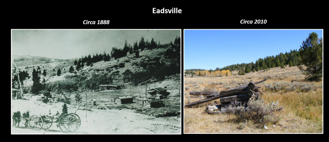
John Eads platted a town (Eadsville) in the center of the mineral district 10 miles south of Casper on Casper Mountain in 1890. Prospectors expected riches of gold and silver but found only traces of the ore with insignificant amounts of copper and other ores. Mining of asbestos and feldspar had some minor success. Asbestos mills were constructed and near Asbestos Spring (Northwestern Mills and Power Company) and along upper Smith Creek (Worming Consolidated Asbestos Company). There were also small disseminated concentrations of chromium in schist deposits. Eadsville reported an exaggerated population of 5,000 eager to begin mining operations in 1892 (Logue, et al., 2017) but economic ore bodies were never discovered. The town’s population vanished as quickly as their dreams of wealth.
Mining town of Eadsville on Casper Mountain.
Image: 1888:Logue, T.J., Katherman, M., Knittle, P., Van Burgh, D., Jr., and Strube, B.E., 2017, A Field Guide to the Casper Mountain Area, Second Edition: The Wyoming Field Science Foundations, Unnumbered Fig., p. 47; 2010: Motsch, J., 2010, http://www.wyolife.com/Outdoors/Outdoors.htm
Image: 1888:Logue, T.J., Katherman, M., Knittle, P., Van Burgh, D., Jr., and Strube, B.E., 2017, A Field Guide to the Casper Mountain Area, Second Edition: The Wyoming Field Science Foundations, Unnumbered Fig., p. 47; 2010: Motsch, J., 2010, http://www.wyolife.com/Outdoors/Outdoors.htm
John Eads, one of Casper’s founders and the mining towns namesake, had his criminal ways finally catch up with him when he was convicted of horse theft in Big Horn County. He was sentenced to the penitentiary in 1908. A.E. Minium became the new promoter of mineral wealth to be had on Casper Mountain. First gold, then asbestos were the ores of choice. But Minium was a shady character too, and in 1916, pleaded guilty to mail fraud in defrauding investors. He was charged with fraudulent asbestos claims in Arizona again in 1920. He managed to avoid jail in Wyoming and Arizona but his career in mining was effectively ended.
Casper Dunefield
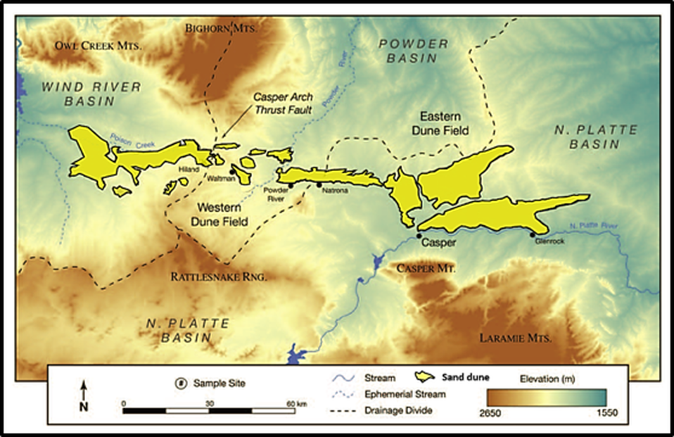
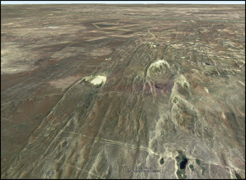
The Casper Dunefield is located north of the North Platte River. The field is 112 miles long extending from Shoshoni to Glenrock and encompasses an area of 772 square miles. The sand has an intermediate level of maturity (based on mineral content). Mechanical abrasion is the main process for the reduction of feldspar and carbonate grains. The sand is sourced from the North Platte drainage that is eroding the Precambrian granite-gneiss terrane to the southwest. Casper is located at the junction of two wind corridors in Wyoming. The winds here generated mainly parabolic dunes. These dunes begin when the wind erodes a cup-shaped area of bare sand on a plant stabilized dune field. The sandy depression is called a blowout or deflation hollow. A U-shaped mound of sand accumulates on the downwind side of the hollow, with long arms pointing upwind (geometry is the reverse of a barchan or crescentic dune).
Casper Dunefield map.
Image: After Hal fen, A.F., Fredlund, G.G., Mahan, S.A, 2010, Holocene stratigraphy and chronology
of the Casper Dune Field, Casper, Wyoming, USA: The Holocene, Vol. 20, Issue 5, Fig. 2, p. 775, http://glaciers.pdx.edu/fountain/readings/HoloceneClimate/HalfenEtAl2010_HolocenDuneActivityWyoming.pdf
Image: After Hal fen, A.F., Fredlund, G.G., Mahan, S.A, 2010, Holocene stratigraphy and chronology
of the Casper Dune Field, Casper, Wyoming, USA: The Holocene, Vol. 20, Issue 5, Fig. 2, p. 775, http://glaciers.pdx.edu/fountain/readings/HoloceneClimate/HalfenEtAl2010_HolocenDuneActivityWyoming.pdf
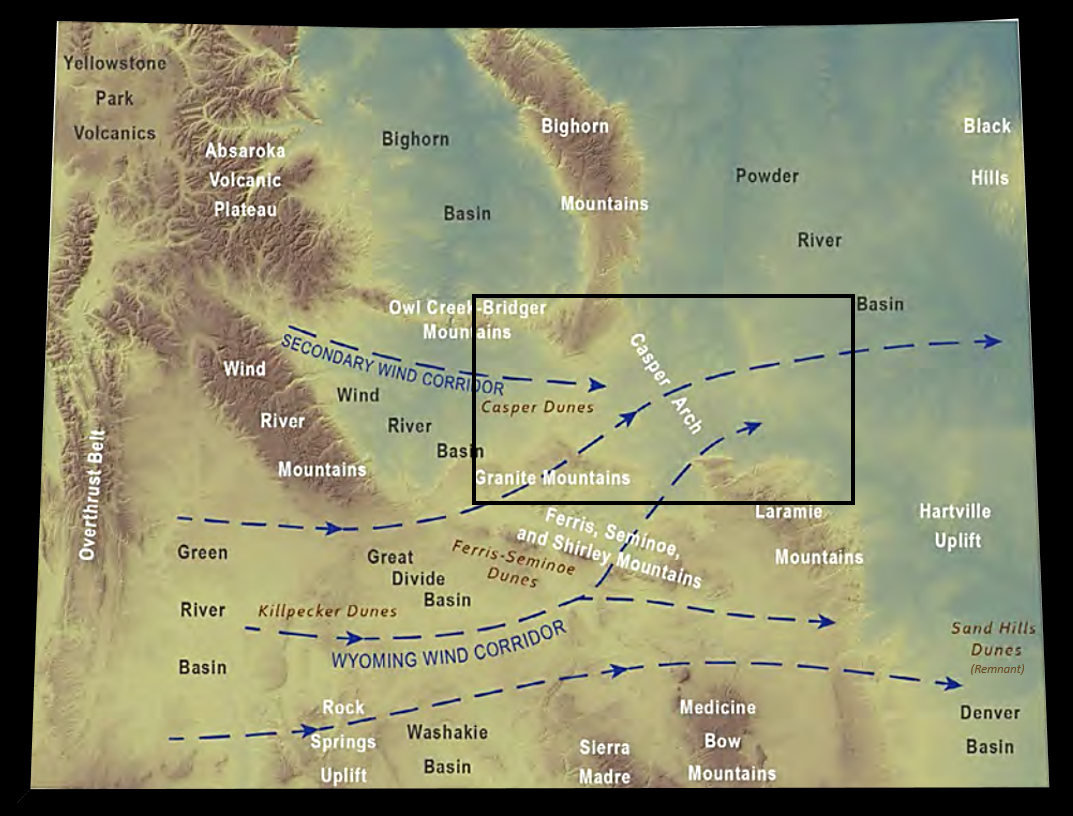
Wyoming wind corridors. The southern primary corridor westerly flow begins in the Great Basin of Utah across the low point in the continental divide in the Great Divide basin (Red Desert basin) and is responsible for deposition of the Killpecker and Ferris-Seminoe dunes. A secondary corridor flows across the Wind River and Powder River basins. The Casper dune field was deposited from the combined flow from the Wind River basin corridor and the southern primary wind corridor through gaps in the mountains between South Pass and the Seminoe Mountains. Black rectangle shows the area of the Casper Dunefield map displayed above.
Image: AfterLoveland, A.M., and Rodgers, J.R., 2017, Evaluation of selected Wyoming silica sand deposits as potential sources of proppant: Wyoming State Geological Survey Report of Investigations 75, Fig. 11, p. 9, http://www.wsgs.wyo.gov/products/wsgs-2017-ri-75.pdf.
Image: AfterLoveland, A.M., and Rodgers, J.R., 2017, Evaluation of selected Wyoming silica sand deposits as potential sources of proppant: Wyoming State Geological Survey Report of Investigations 75, Fig. 11, p. 9, http://www.wsgs.wyo.gov/products/wsgs-2017-ri-75.pdf.
East-northeast view (downwind) of inland parabolic dunes north of Casper.
Image: Google Earth
Image: Google Earth
Morphology of a parabolic dune. Bison were trapped in the blowout area of the U-shaped dune face and killed by the hunters.
Image: https://www.slideshare.net/aikyatha/arid-aeolian-landform
Image: https://www.slideshare.net/aikyatha/arid-aeolian-landform
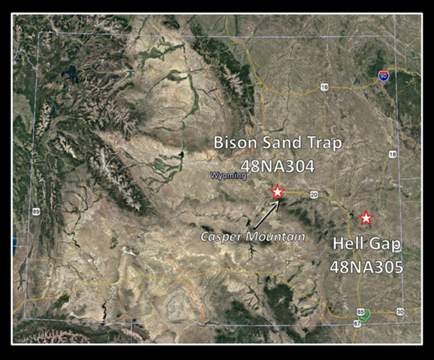
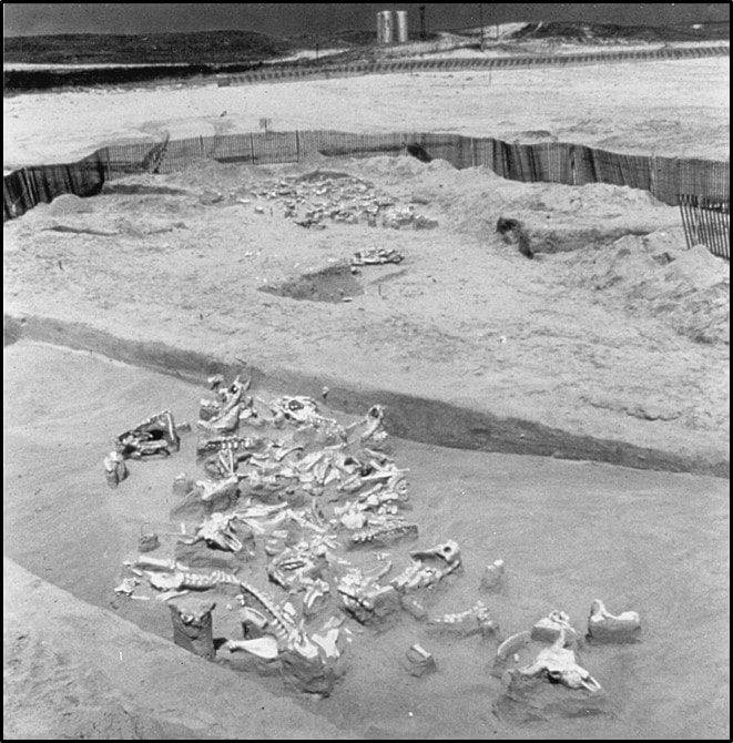
In 1971, a Hell Gap-age (10,800-7,500 before present) bison kill site was discovered in the Casper Dunefield. The dune trap is 1,200-1,800 feet long, 400-500 feet wide and 35-50 feet high. The skeletal remains of about 100 bison and 1 camelwere excavated from within the margins of the 10,000-year-old parabolic sand dune trap. The split-hooved bison, and lone camel, were unable to climb the steep sides of the surrounding sand. The site is located on the highest (oldest) river terrace north of the river in the northeast quarter of Section 5, Township 33 North, Range 79 West (48NA304 Smithsonian archaeological reference code). Charcoal and bone yielded a radiometric date of 8050 BCE (10,000 BP).
Hell Gap Complex sites in east central Wyoming.
Image: Google Earth
Image: Google Earth
Ten-thousand-year-old bison bone bed in the bottom of a parabolic sand dune at the Casper site.
Image:Frison, G.C., 1998, Paleoindian large mammal hunters on the great plains of North America: PNAS 95 (24), Fig. 8, http://www.pnas.org/content/pnas/95/24/14576.full.pdf
Image:Frison, G.C., 1998, Paleoindian large mammal hunters on the great plains of North America: PNAS 95 (24), Fig. 8, http://www.pnas.org/content/pnas/95/24/14576.full.pdf
19thcentury explorers searched for wealth on Casper Mountain where the geology did not provide it. The Precambrian rocks did not have enough high concentrations of ore or minerals to justify large mining operations. The early Casperites could not recognize the valuable resource that was right before their eyes, the wind. The persistent wind that generated the sand dunes was an energy resource that was discovered and began to be exploited in the late 20th century. Recreational value of the mountain landscape and region is now recognized and enjoyed by all.
Casper area wind farms. Chevron produces 16.5 megawatt that is purchased by PacifiCorp. Duke’s farm produces 99 megawatts that is also purchased by PacifiCorp. The State of Wyoming can produce 883 megawatt-hour per year from wind power thanks to the geology that produced its wind corridors.
Image: Top Left: https://www.slideshare.net/cphcleantech/copenhagen-cluster-trond-unnelandoct2011; Top Right: https://www.hcn.org/issues/45.22/the-latest-first-federal-prosecution-of-wind-farm-bird-deaths; Bottom:
Google earth and https://bsoza.com/illust/ill_topic/cenergy_a02.htm‘
Image: Top Left: https://www.slideshare.net/cphcleantech/copenhagen-cluster-trond-unnelandoct2011; Top Right: https://www.hcn.org/issues/45.22/the-latest-first-federal-prosecution-of-wind-farm-bird-deaths; Bottom:
Google earth and https://bsoza.com/illust/ill_topic/cenergy_a02.htm‘
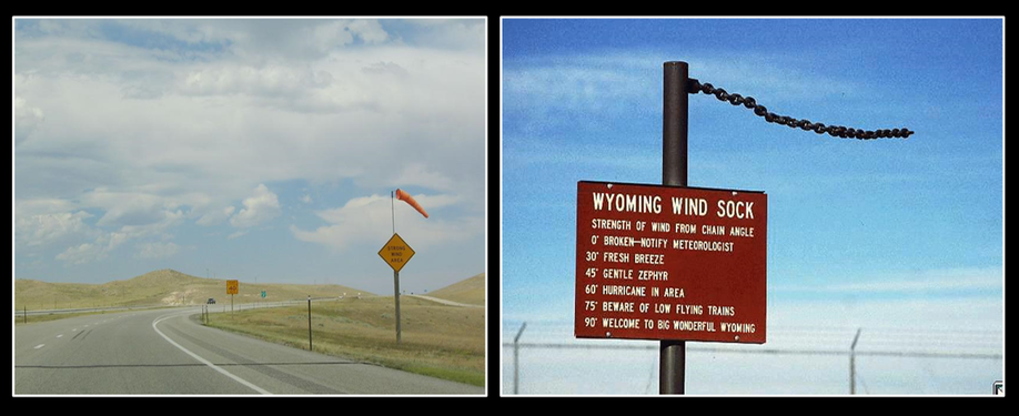
Wyoming wind socks: I-25 North near Bordeaux (eastern end of the primary wind corridor), about 10 miles south of Wheatland (first wind sock installed by the Wyoming Department of Transportation over 35 years ago); Right: University of Wyoming’s National Weather Service Cheyenne link.
Image: Left: AA Roads, 2014, Interstate 25 Northbound - Platte County, Photo 23 of 71, https://www.aaroads.com/west/i-025nb_wy.html; Right: http://www.wrds.uwyo.edu/wrds/nws/nws.html
Image: Left: AA Roads, 2014, Interstate 25 Northbound - Platte County, Photo 23 of 71, https://www.aaroads.com/west/i-025nb_wy.html; Right: http://www.wrds.uwyo.edu/wrds/nws/nws.html
Things To Do
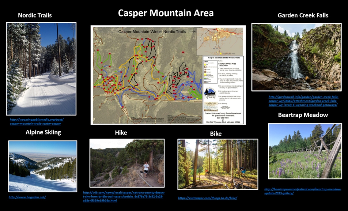
Year-round recreational opportunities.

The material on this page is copyrighted
