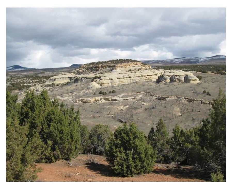
Tensleep Sandstone ancient dune complex
Image by Mark Fisher
Image by Mark Fisher
Wow Factor (4 out of 5 stars):
Geologist Factor (4 out of 5 stars):
Attraction
Remote and isolated part of Wyoming at foot of Bighorn Mountains, cliffs of cross-bedded sandstone from an ancient sand dune complex, petroglyphs and pictographs, pretty state park campground in canyon along creek with cottonwood trees. Hike, fish, mountain bike or horseback ride up scenic Paint Rock Canyon. ATV or dirt bike on miles of roads on flank of Bighorns. This is a special area if you like geology, archaeology, wilderness, and outdoor activities.
Geology of Medicine Lodge Tensleep
Sand dunes in the movies have been home to moisture farmers and droids in Star Wars, giant sand worms in Dune and man-eating quicksand in Lawrence of Arabia. In the Bighorn Basin, the fossil sand dunes of the Tensleep are habitat to the largest oil reservoir in the state.
Sand dune habitats portrayed in film.
Left: Star Wars droids at Lar’s moisture farm, http://eleven-thirtyeight.com/wp-content/uploads/2014/05/star-wars-r2-d2-and-c-3po-fototapetertapeter-176x176.jpg; Center: Dune sandworm rising on Arrakis; Right: Lawrence of Arabia quicksand scene, https://www.youtube.com/watch?v=FrLba1rE4sY.
Left: Star Wars droids at Lar’s moisture farm, http://eleven-thirtyeight.com/wp-content/uploads/2014/05/star-wars-r2-d2-and-c-3po-fototapetertapeter-176x176.jpg; Center: Dune sandworm rising on Arrakis; Right: Lawrence of Arabia quicksand scene, https://www.youtube.com/watch?v=FrLba1rE4sY.
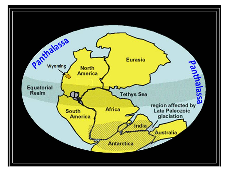
Five miles northeast of Hyattville, Wyoming the Tensleep Sandstone is exposed in outcrops in the Medicine Lodge area. These exposures are the preserved record of a middle to late Pennsylvanian age complex of wind-blown sand dunes developed on the Wyoming shelf, at the eastern shifting margin of the Panthalassa Ocean.
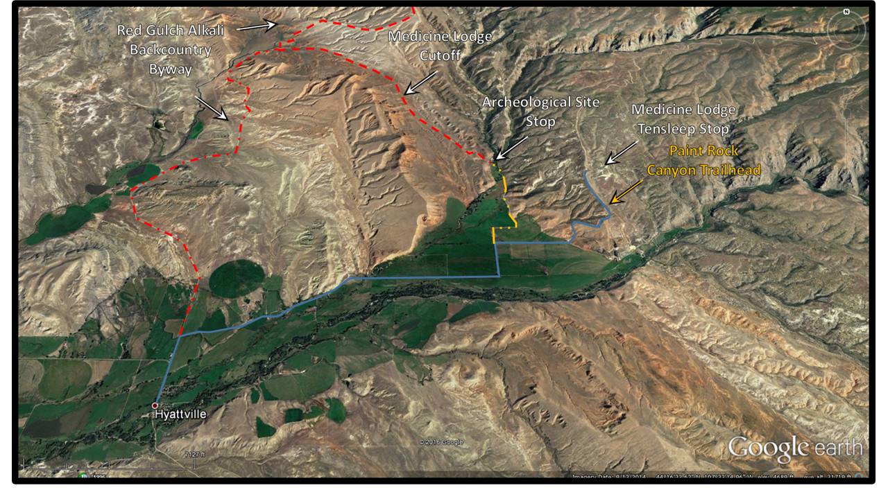
North aerial view of Medicine Lodge area showing roads. Blue solid line: Cold Springs Rd; Red dashed line: Red Gulch/Alkali National Backcountry Byway; Yellow dot dashed line: Road 268A.
Image: Google Earth
Image: Google Earth
Late Paleozoic-Mesozoic supercontinent Pangea and superocean Panthalassa.
Image: After USGS Geology of the New York City Region, https://www.usgs.gov/science-support/osqi/yes/national-parks/geology-new-york-city-region-0
Image: After USGS Geology of the New York City Region, https://www.usgs.gov/science-support/osqi/yes/national-parks/geology-new-york-city-region-0
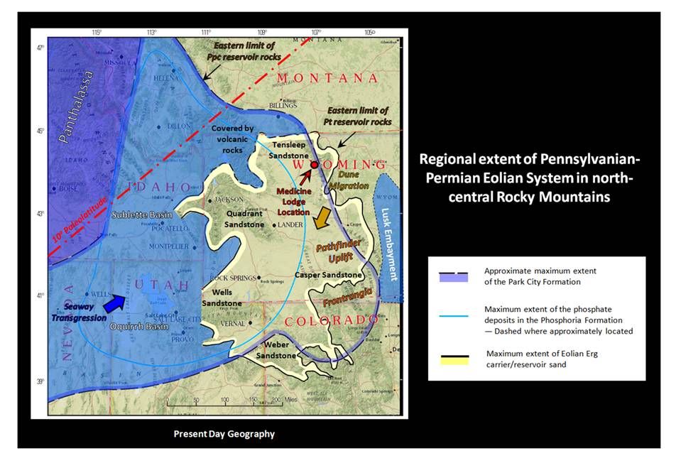
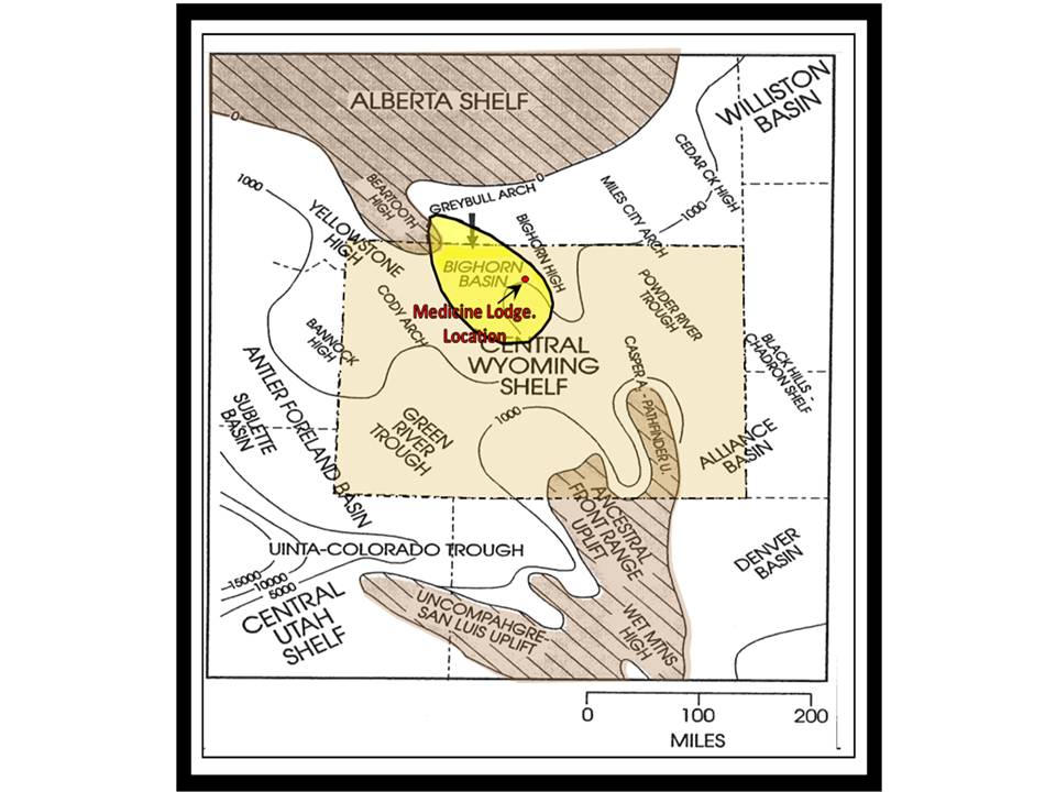
The Tensleep is part of a vast Pennsylvanian sand dune system that developed north of the Ancestral Rocky Mountains as Africa collided with the North American continent. The Bighorn Basin portion of the Pennsylvanian Central Wyoming Shelf was a restricted coastal plain area over which a southward migrating sand sea interacted with sea level changes.
The Pennsylvanian eolian system. Formation names applied in geographic area are posted. The Ancestral Rocky Mountain Uplifts are labeled in orange italics. The Panthalassa Ocean and the flooded Cordilleran basins (Sublette and Oquirrh) mark the western margin. The “Lusk Embayment” is a continental seaway that lies along the eastern margin. The Ancestral Rocky Mountains comprised the southern margin of the eolian system. Arkosic fan and stream deposits interfinger with the Casper Formation dunes adjacent to where these ancient mountains once stood. The long dashed line shows the depositional limits of the Permian Park City Formation (aka Phosphoria), which is the second largest oil reservoir in the state and is often in communication with the Tensleep. The light blue line marks the eastern limit of the Phosphoria hydrocarbon source rock that charged both the Tensleep and Park City Formations. Ppc = Permian Park City Fm.; Pt = Pennsylvanian Tensleep Fm.
Base: Goggle Earth; Overlays: Pp: After Johnson, E.A., 2005, USGS DDS-69-D, Chapter 4, Fig. 3, p. 8; https://pubs.usgs.gov/dds/dds-069/dds-069-d/REPORTS/69_D_CH_4.pdf, Pt: After Johnson, E.A., 2005, USGS DDS-69-B, Chapter 9, Fig. 3, p. 4., https://pubs.usgs.gov/dds/dds-069/dds-069-b/chapters.html
Base: Goggle Earth; Overlays: Pp: After Johnson, E.A., 2005, USGS DDS-69-D, Chapter 4, Fig. 3, p. 8; https://pubs.usgs.gov/dds/dds-069/dds-069-d/REPORTS/69_D_CH_4.pdf, Pt: After Johnson, E.A., 2005, USGS DDS-69-B, Chapter 9, Fig. 3, p. 4., https://pubs.usgs.gov/dds/dds-069/dds-069-b/chapters.html
Bighorn Basin area Permian-Pennsylvanian structural setting. The position of present day basin shown in yellow. The red dot marks the location of the Medicine Lodge outcrop. Contours are thickness.
Figure: Inden, R. F. & Horn, J. C., 1998, MOC BHB Field Trip, Plate 4
Figure: Inden, R. F. & Horn, J. C., 1998, MOC BHB Field Trip, Plate 4
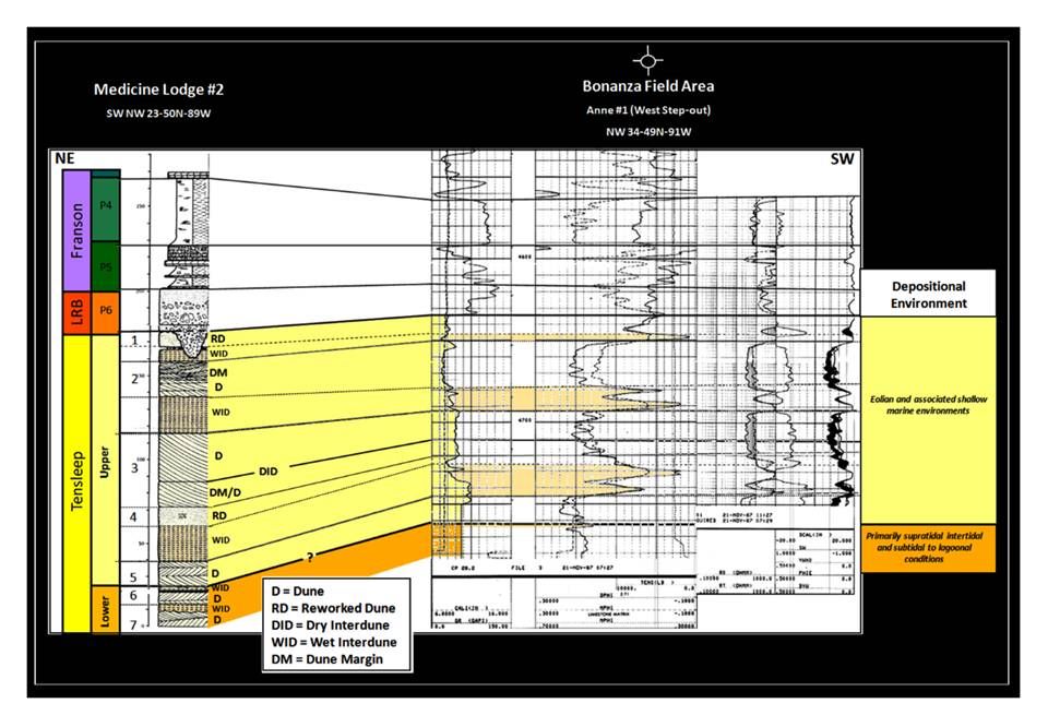
The Tensleep is informally divided into two parts. The lower sand unit is generally between 50-100 feet thick and has thinner sand layers with more marine interbeds. The sea level rose and flooded more frequently onto the western Bighorn Basin, but was limited by the Yellowstone and Beartooth highs on the northwest and the Bighorn high on the east side of the basin. The lower unit was deposited over a 1.5 million year period in the Desmoinesian stage (308-306.5 million years). The thickness of the Upper Tensleep varies from 0-300 feet due to post-depositional erosion. It is dominated by sand dune deposits that are separated by marine dolomites or dolomitic sandstones. It was deposited in the Missourian and Virgilian stage (306.5-299 million years).
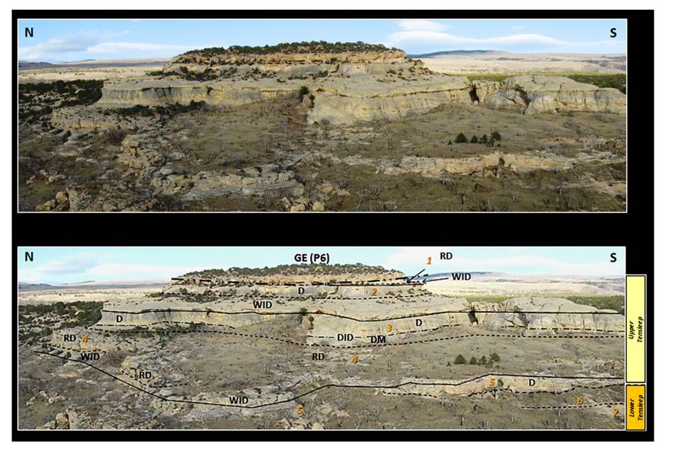
The Medicine Lodge outcrop is an excellent exposure of a 170+ foot thick Tensleep dune complex. Large forset beds developed on the leading edge of dunes and migrated in the direction of prevailing seasonal winds. Between these units are interdune deposits of both wet and dry origin. The interdune type was determined by the water table level at the time of their formation.
The Medicine Lodge outcrop is an excellent exposure of a 170+ foot thick Tensleep dune complex. Large forset beds developed on the leading edge of dunes and migrated in the direction of prevailing seasonal winds. Between these units are interdune deposits of both wet and dry origin. The interdune type was determined by the water table level at the time of their formation.
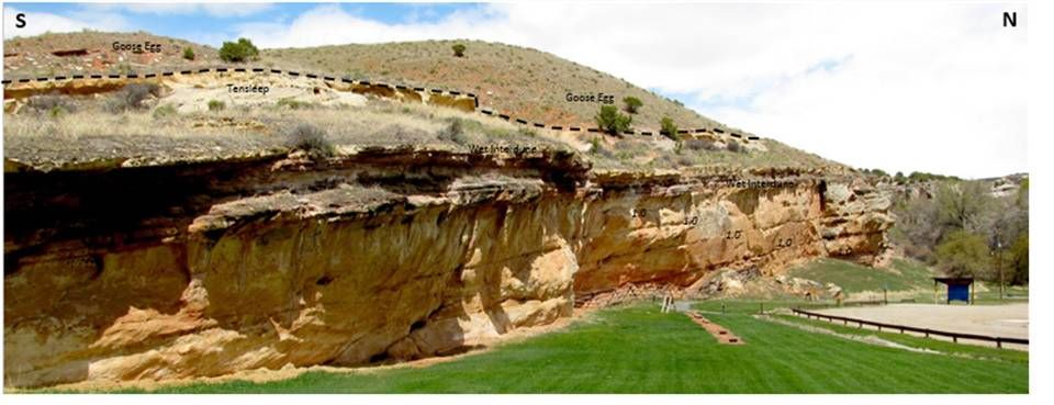
Medicine Lodge dune complex near Hyattville. The Pennsylvanian Tensleep is overlain by a Permian valley fill channel of the Glendo Shale Member of the Goose Egg Formation (P6). This terrigenous channel contains abundant pebbles and cobbles of Tensleep, Phosphoria and chert. Geologic codes shown in cross section below.
Top: Finn, M., 2009, Medicine Lodge Tensleep Image; Bottom: Dune complex elements, Steele, K.K.
Top: Finn, M., 2009, Medicine Lodge Tensleep Image; Bottom: Dune complex elements, Steele, K.K.
Medicine Lodge outcrop correlation to a nearby subsurface well in Bonanza Field area, 15 miles to the southwest. In the subsurface log, the left track is a gamma ray curve scaled 0 to 160 API units (left to right). When the gamma ray curve is near the left edge, the sand is clean with minimal clay content. When the curve moves to the right, it indicates more clay content. The two curves in the middle, just to the right of the depth track are neutron porosity (dash) and density porosity (solid) curves scaled from +30% porosity to -10% porosity (left to right). When the curves are toward the left, it indicates higher porosity and when the curves move to the right, it indicates lower porosity.
Outcrop: After RPI, 1985, Outcrop Description, Appendix; Correlation: Steele, K.
Outcrop: After RPI, 1985, Outcrop Description, Appendix; Correlation: Steele, K.
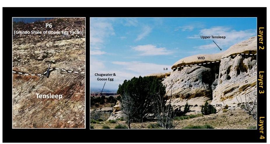
Left: The Upper Tensleep erosional contact with overlying Glendo Shale Member of the Goose Egg Formation; Right: Dune features including wet interdune (WID), planar forest beds (D), dry interdune (DID), and reworked dune deposit (RD).
Left: Wheeler, D., 1986, M.S. Thesis, Colorado School of Mines, Fig. 22, p. 55: Right: After Lanz, R., 2006 Medicine Lodge Image
Left: Wheeler, D., 1986, M.S. Thesis, Colorado School of Mines, Fig. 22, p. 55: Right: After Lanz, R., 2006 Medicine Lodge Image
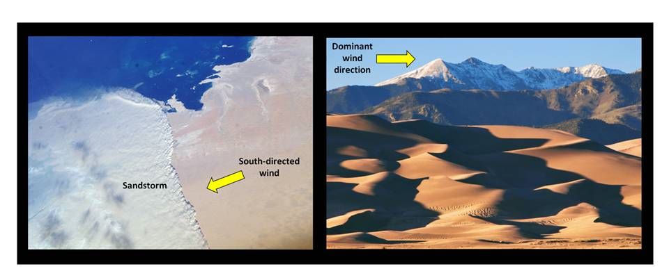
Modern analogs for the Pennsylvanian Tensleep Dune Complex. Left: International Space Station view of dune complex at sea margin with southward directed sandstorm in Qatar, Arabian Peninsula; Right: Dune complex at mountain front in Great Sand Dunes National Park and Preserve, Colorado.
Left Image: http://eoimages.gsfc.nasa.gov/images/imagerecords/4000/4256/Qatar_ISS008-E-16355_1000_lrg.jpg
Right Image: https://www.nps.gov/common/uploads/photogallery/imr/park/grsa/FB1BFF10-155D-451F-67C2FAC1CA54425A/FB1BFF10-155D-451F-67C2FAC1CA54425A.jpg
Left Image: http://eoimages.gsfc.nasa.gov/images/imagerecords/4000/4256/Qatar_ISS008-E-16355_1000_lrg.jpg
Right Image: https://www.nps.gov/common/uploads/photogallery/imr/park/grsa/FB1BFF10-155D-451F-67C2FAC1CA54425A/FB1BFF10-155D-451F-67C2FAC1CA54425A.jpg
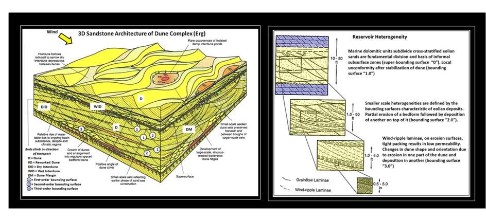
Diagrammatic model of a dune complex and the resulting reservoir heterogeneity within the dune system.
Left Diagram: After Mountney, N. P., 2006, Sedimentology, Fig.17D, p. 813.
Right Diagram: After Carr-Crabaugh, M. & Dunn, T. L., 1996, Tensleep DOE Final Tech. Rpt., Fig. 1.18, p. 37.
Left Diagram: After Mountney, N. P., 2006, Sedimentology, Fig.17D, p. 813.
Right Diagram: After Carr-Crabaugh, M. & Dunn, T. L., 1996, Tensleep DOE Final Tech. Rpt., Fig. 1.18, p. 37.
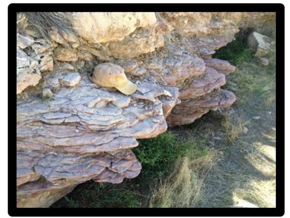
Purple dolomitic sandstone layer that marks the boundary between the upper and lower Tensleep at Medicine Lodge.
Image: Steele, K.K., 2009, Medicine Lodge interdune marker bed.
Image: Steele, K.K., 2009, Medicine Lodge interdune marker bed.
The first reported oil in the Bighorn Basin was from a seep discovered in 1884. It was located 15 miles southwest of Medicine Lodge along a creek near Bonanza anticline. The seep flowed from the Thermopolis Shale. The Bonanza anticline was the site of the first exploration wells drilled in the Bighorn Basin in 1888. All the early wildcat wells were dry holes and were too shallow to reach the Tensleep Sandstone. Although the Tensleep Sandstone was found to be a prolific oil reservoir on other structures in the Bighorn Basin from the 1920s on, it was not until 66 years after discovery of the oil seep that production was found in the Tensleep reservoir at Bonanza field.
The Tensleep reservoir in the Bighorn Basin has a cumulative production of over 2 billion barrels of oil from about 3800 wells in 58 oil fields. The Medicine Lodge outcrop is an excellent place to examine this reservoir in a 40 acre, three-dimensional, preserved sand dune outcrop from about 300 million years ago.
The Tensleep reservoir in the Bighorn Basin has a cumulative production of over 2 billion barrels of oil from about 3800 wells in 58 oil fields. The Medicine Lodge outcrop is an excellent place to examine this reservoir in a 40 acre, three-dimensional, preserved sand dune outcrop from about 300 million years ago.
Medicine Lodge Archeological Site
Human occupation of this site dates from 10,000 years ago. The native people probably used the area as a campsite. The location provided rock shelter, water and food (game animals and excellent fishing). They recorded their passing with petroglyphs and pictograms etched into the Tensleep Sandstone cliff face. The rock art is thought to be from the last 1,000 years.
Two views of the geology of the Medicine Lodge Archeology site. The top image displays depositional facies in white and bounding surfaces with black numerals. Bottom image both depositional facies and bounding surface in black.
Top, Image: http://wyomingroadtripbythemilemarker.com/resources/Medicine+Lodge+State+Archaeological+Site.jpg; Geology: Steele, K.K., 2009, BHB Field Seminar Guidebook
Bottom, Image: http://1.bp.blogspot.com/_3mUW-98a1yY/S-7_rICMqOI/AAAAAAAAgaQ/rCrfWUxHP8E/s1600/33-266.JPG ; Geology: Steele, K.K., 2009, BHB Field Seminar Guidebook
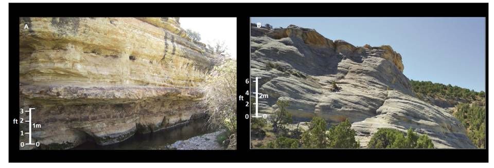
View of the Tensleep members at Medicine Lodge. The left image (A) shows the marine sandstones of the lower Tensleep. The right image (B) shows the ancient dune deposits of the Upper Tensleep.
Images: After Morgan, J.K., 2015, Stratigraphy and Tectonic Implications of the Tensleep Sandstone, NE Bighorn Basin, WY: M.S. Thesis, University of Houston, Fig 2.3, p. 24. https://uh-ir.tdl.org/uh-ir/handle/10657/1249
Images: After Morgan, J.K., 2015, Stratigraphy and Tectonic Implications of the Tensleep Sandstone, NE Bighorn Basin, WY: M.S. Thesis, University of Houston, Fig 2.3, p. 24. https://uh-ir.tdl.org/uh-ir/handle/10657/1249
Things To Do in Medicine Lodge and Hyattville Area
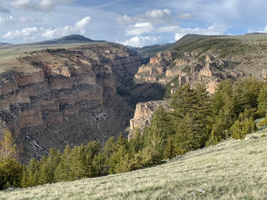
Medicine Lodge Wilderness Study Area with cliffs of Mississippian Madison and Ordovician Big Horn Formations
Picture by Mark Fisher
Picture by Mark Fisher
This area has a lot to offer. We recommend the following three main attractions: 1) Medicine Lodge State Archaeological Site, 2) Paint Rock Canyon, and 3) the Medicine Lodge Tensleep Sandstone outcrop complex.
The archaeological site is a pretty setting with bluffs of Tensleep Sandstone, petroglyphs and pictographs, a small log cabin museum, a corral, a clear stream, cottonwoods, green grass and a campground nestled in a peaceful spot. There is an entrance fee. The campground is popular on weekends. After a Wyoming winter, locals are anxious to start the camping season and Medicine Lodge is one of the first places in the basin to warm-up. You can reserve a campsite on-line. There is very rugged terrain in the adjacent Medicine Lodge Wilderness Study Area. There are also ATV roads heading up Dry Medicine Lodge Creek and Cold Springs Road onto the flank of the Bighorns.
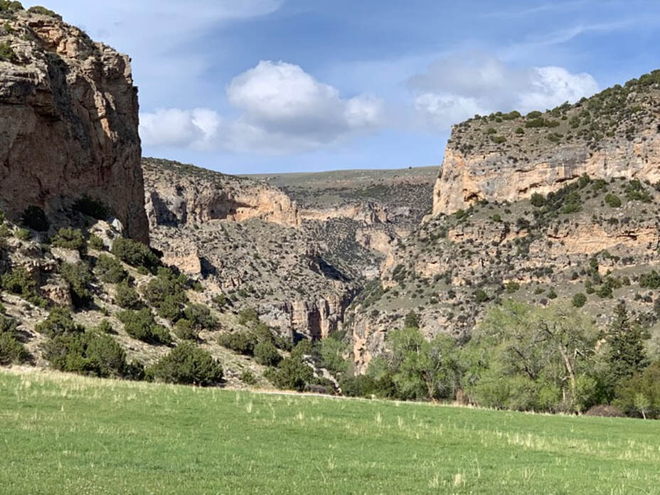
Paint Rock Canyon is a special place to hike, fish, mountain bike or horseback ride with cottonwood trees along a beautiful cold water trout stream that has cut up to 1,000 foot walls into the Madison and Bighorn carbonates. The trail begins on Cold Spring road and traverses about a mile of cedar and juniper before dropping into the entrance of the canyon. You then follow a dirt two-track for 5+ miles upstream. A portion of the trail is on private land when you drop into the canyon, but the BLM trail has approved access from May 11 through September 30. We think you will enjoy this canyon!
The Medicine Lodge Tensleep Sandstone outcrop complex is a great place to see an ancient sand dune. You will see Lower Tensleep in the arroyo with interbedded low-angle cross-bedded marine sandstone and thin dolomites. Most of the outcrop is Upper Tensleep Sandstone deposited in wind blown dunes, dune margins, and interdune settings. The top of the outcrop has the erosional contact between the Tensleep and overlying Goose Egg. This ancient erosion interval is marked by clasts of chert, dolomite and reworked Tensleep Sandstone. This same erosion surface can be seen along the Cold Springs road where you park for this outcrop. The size of this outcrop is similar to what a single vertical Tensleep oil well would drain in the subsurface oil fields in the basin. Thus it makes an excellent stop for petroleum geoscientists and engineers to touch and see an example of their reservoir.
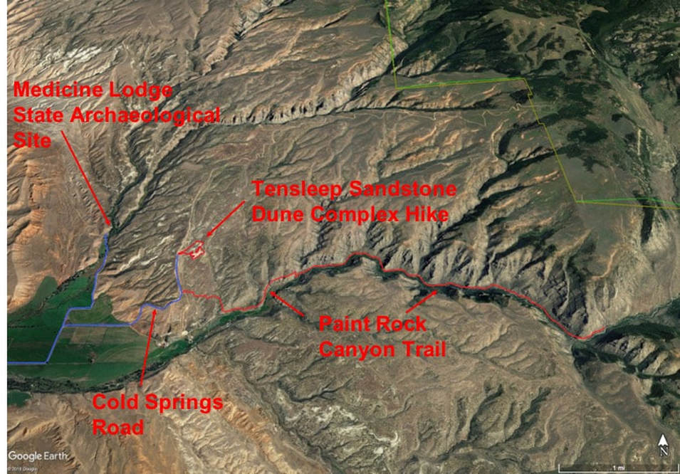
Map to Paint Rock Canyon hike, Medicine Lodge Tensleep Sandstone Dune Complex hike and Medicine Lodge State Archaeological Site. Access roads in blue and hikes in red.
Google Earth Image
Google Earth Image
Directions to Medicine Lodge State Archaeological Site
If you have time (about 2 hours) and inclination to explore, our recommendation is to take the Red Gulch Alkali National Scenic Byway from east of Greybull to the Hyattville/Medicine Lodge area. Visit our two other web pages on the Byway (Red Gulch Dinosaur tracksite website and Red Gulch Alkali Byway website). If you want to take the Byway, head east of Greybull on US 14, at 10.5 miles turn right on Red Gulch/Alkali Backcountry Byway. Once you are on the Byway, it is 32 miles of dirt road to the Hyattville/Medicine Lodge area. There are no gas stations, restaurants or stores on the Byway. Take everything you will need for the entire day.
If you want to get to the Medicine Lodge area more quickly (about an hour), start at the only traffic light in downtown Greybull at the intersection of US 14 and US 16-20, head toward Basin and Manderson on US 16-20, 7.7 miles center of Basin, 18.7 miles turn left on Wyoming 31 at town of Manderson and head toward Hyattville, 33.2 miles go straight on WY 31/do not turn to town of Tensleep, just a half mile before reaching Hyattville at 40.1 miles turn left on Alkali –Cold Springs Road, 40.4 miles turn right on Cold Springs Road (straight is Red Gulch Alkali Back Country Byway), 42.6 miles red bluff on left is Triassic Chugwater siltstones and shales, 43.6 miles road takes a hard left curve, 44.1 miles go straight/bear left on County Road 52 (Cold Springs road takes hard right at this junction), 45.5 miles arrive at Medicine Lodge State Archaeological Site, 45.9 miles petroglyph site.
If you want to get to the Medicine Lodge area more quickly (about an hour), start at the only traffic light in downtown Greybull at the intersection of US 14 and US 16-20, head toward Basin and Manderson on US 16-20, 7.7 miles center of Basin, 18.7 miles turn left on Wyoming 31 at town of Manderson and head toward Hyattville, 33.2 miles go straight on WY 31/do not turn to town of Tensleep, just a half mile before reaching Hyattville at 40.1 miles turn left on Alkali –Cold Springs Road, 40.4 miles turn right on Cold Springs Road (straight is Red Gulch Alkali Back Country Byway), 42.6 miles red bluff on left is Triassic Chugwater siltstones and shales, 43.6 miles road takes a hard left curve, 44.1 miles go straight/bear left on County Road 52 (Cold Springs road takes hard right at this junction), 45.5 miles arrive at Medicine Lodge State Archaeological Site, 45.9 miles petroglyph site.
Directions to Paint Rock Canyon Hike
Paint Rock Canyon with cliffs of Mississippian Madison Formation
Picture by Mark Fisher
Picture by Mark Fisher
Starting at the State Archaeological Site, 0.0 miles leave park, 1.4 miles turn left at junction onto Cold Springs Road, 2.1 miles take left fork on Cold Springs Road, cross cattle guard and road becomes gravel (do not take right fork on Lane 49-1/2 which becomes private road to Paint Rock Canyon), 2.6 miles dry creeks on left of road have outcrops of Tensleep Sandstone, 3.1 miles park on left in pull-off for Paint Rock Canyon Trail, trail starts across the road or right. On this trail you can hike, mountain bike or ride a horse from May 11 to September 30. The trail traverses dry rolling terrain with cedars and junipers for almost a mile until dropping a short distance to the canyon. Once you are in the canyon on a dirt road, you can walk upstream (left or east) for about five miles. The trail ends more or less where the BLM removed the bridge over the creek. At that point, a trail picks up across the creek and continues upstream eventually to the Cold Springs Road. Crossing this stream is dangerous! A write-up of mountain biking down from the top is at the following link https://www.wikiloc.com/wikiloc/view.do?id=2009720. I have done the complete bike ride from the top in the early fall when fording the creek was less dangerous.
Directions to Medicine Lodge Tensleep Sandstone Dune Complex
Starting at the State Archaeological Site, follow the same directions as going to the Paint Rock Canyon trail head, but continue for an additional 0.6 miles and park on right side of road at 3.6 total miles from archaeological site. Outcrop complex is about 1,000 feet to the right or east. We usually walk around the outcrop in counter clockwise direction and gain access to the top from the more gentle backside. Total distance walking to outcrop, around base and back to the vehicle is slightly over one mile. This is all federal land. If you want to see the Tensleep Sandstone without the hike, just walk or drive a few more tenths of a mile up the road.

The material on this page is copyrighted
