Geology of Wyoming
  • Home
    • Wow Factor
    • Geological Factor
    • Stratigraphic Column
    • Wyoming Links
    • About The Geologists
    • Contact Us
  • Map of GeoWyo Top Spots
  • Albany-Laramie Counties
    • Big Hollow
    • Como Bluff
    • Snowy Range Stromatolites
    • Sybille Canyon - WY Highway 34
    • Vedauwoo
    • Wyoming Diamonds
  • Big Horn County
    • Ancient River Channel & Sheep Mountain
    • Bighorn Canyon
    • Bighorn Mountain Byways Part I
    • Bighorn River Area Caves
    • Devil's Kitchen
    • Medicine Lodge Tensleep Sandstone
    • Red Gulch Alkali Backcountry Byway
    • Red Gulch Dinosaur Tracksite & Sundance Seaway
    • Shell Dinosaur Bone Beds
  • Campbell County
    • Pumpkin Buttes
  • Carbon County
    • Battle Pass Byway - WY Highway 70
    • Encampment & Sierra Madre Mtns
    • Freezeout Hills
    • Rawlins Uplift
    • Shirley Basin
  • Converse County
    • Ayres Natural Bridge
    • Douglas Crater Field
  • Crook County
    • Devils Tower & Black Hills
  • Fremont County
    • Gas Hills & Crooks Gap Uranium
    • Red Canyon
    • Sinks Canyon
    • South Pass
  • Goshen-Platte Counties
    • Fort Laramie & Hartville Uplift
    • Goshen Hole
  • Hot Springs County
    • Anchor Dam
    • Dinosaur Marbles
    • Thermopolis Hot Springs
    • Wind River Canyon Part 1
    • Wind River Canyon Part 2
  • Johnson County
    • Crazy Woman Canyon
    • Hole In The Wall & Red Wall Country
  • Laramie County
    • Cheyenne Tablelands and Gangplank
  • Lincoln County
    • Fossil Butte
    • Periodic Spring
  • Natrona County
    • Bessemer Bend
    • Casper Mountain
    • Ervay Basin
    • Granite Mountains
    • Hells Half Acre
    • Rattlesnake Hills
  • Niobrara County
    • Lusk Area
  • Park County
    • Absaroka Volcanic Province
    • Beartooth Highway
    • Buffalo Bill Dam & Rattlesnake Mtn.
    • Clarks Fork Canyon
    • Cody Hydrothermal System
    • Dead Indian Hill
    • The Great Unconformity
    • Heart Mountain
    • Kirwin
    • Oregon Basin Oil Field
    • McCullough Peaks
    • Polecat Bench & PETM
    • Sunlight Basin
    • Tatman Mountain & Squaw Peaks
  • Sheridan County
    • Bighorn Mountain Byways Part II
  • Southeast Wyoming
    • North Platte River: One Dammed Thing After Another
  • Southern Powder River Basin
    • K-T Boundary
  • Sublette County
    • Titcomb Basin
  • Sweetwater County
    • Adobe Town
    • Flaming Gorge
    • Lake Gosiute & the Blue Forest
    • Leucite Hills
  • Teton County
    • Gros Ventre Range & Granite Hot Springs
    • Northern Tetons Geologic Wonders
    • Two Ocean Pass
  • Uinta-Lincoln Counties
    • Wyoming Thrust Belt
  • Washakie County
    • Big Cedar Ridge
    • Castle Gardens
    • Tensleep Canyon & Sweet 16
    • Upper Nowood River Valley
  • MONTANA
    • Crazy Mountains and Basin
    • Grasshopper Glacier
    • Nye-Bowler Fault Zone
    • Pryor Mountains
    • Red Lodge - Bear Creek Coal
  • IDAHO
    • Teton Dam Failure

Map of GeoWYO TOP Spots

When we travel, we consult guidebooks and websites that lead us to the best experiences.  We spend hours driving between highly publicized and sometimes crowded spots, knowing we are undoubtedly passing world-class spots and geological wonders that only locals enjoy.  Wyoming has more than its fair share of special geological places if you just knew where to go and what makes them special. 

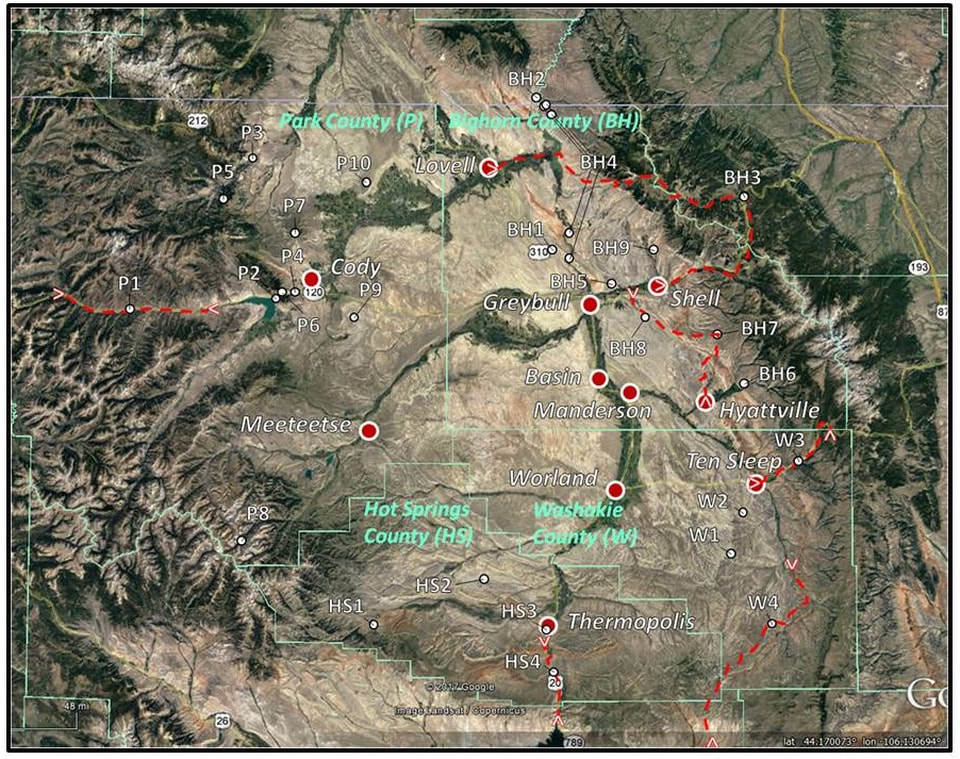
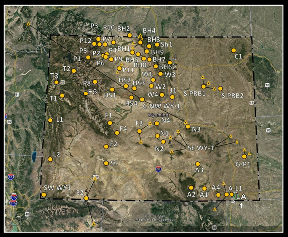
​The maps below show the location of our Geology Top Spots in Wyoming and specifically the Bighorn Basin.  We have a webpage for each spot and the list below has a link to each page.
Map of Bighorn Basin with geology top spots, Wyoming
Picture
Albany-Laramie Counties

A1 Big Hollow

​A2 Snowy Range Stromatolites

A3 Como Bluff

A4 Vedauwoo

​A-L1 Wyoming Diamonds

A-P1 Sybille Canyon - WY Highway 34

Bighorn County
​

BH 1 Ancient River Channel & Sheep Mountain

BH2 Bighorn Canyon

​BH3 Bighorn Mountain Byways Part I


​BH4 Bighorn River Area Caves

BH 5 Devil's Kitchen

BH6 Medicine Lodge Tensleep Sandstone

BH7 Red Gulch Alkali Backcountry Byway

BH8 Red Gulch Dinosaur Tracksite & Sundance Seaway

​BH9 Shell Dinosaur Bone Beds
Campbell County

CM1 Pumpkin Buttes
Carbon County

CA1 Encampment & Sierra Madre Mountains

CA2 Shirley Basin

​CA3 Rawlins Uplift

​Ca4 Freezeout Hills
Converse County

​CV1 Ayres Natural Bridge

​CV2 Douglas Crater Field

Crook County

​C1 Devils Tower & Black Hills
Fremont County

​F1 Sinks Canyon

F2 South Pass

​F3 Gas Hills & Crooks Gap

F4 Red Canyon

Goshen-Platte Counties

G1 Goshen Hole

G-P1 Fort Laramie & Hartville Uplift
Hot Springs County

HS1 Anchor Dam

HS2 Dinosaur Marbles

​HS3 Thermopolis Hot Springs

​HS4 Wind River Canyon Part I

​HS4 Wind River Canyon Part II
Johnson County

J1 Hole in the Wall & Red Wall Country

Laramie County

​LA1 Cheyenne Tablelands & Gangplank
Lincoln County

​L1 Periodic Spring

​L2 Fossil Butte
Natrona County

N1 Granite Mountains

N2 Rattlesnake Hills

​N3 Casper Mountain

​N4 Hells Half Acre

N5 Ervay Basin

N6 Bessemer Bend
Niobrara County

Ni 1 Lusk Area
Park County

P1 Absaroka Volcanic Province

​NW WY3 Beartooth Highway

P2 Buffalo Bill Dan & Rattlesnake Mountain

P3 Clarks Fork Canyon

​P4 Cody Hydrothermal System

P5 Dead Indian Hill


P6 The Great Unconformity

​P7 Heart Mountain

P8 Kirwin

P9 Oregon Basin Field

McCullough Peaks

​P10 Polecat Bench & PETM

P11 Tatman Mountain & Squaw Peaks

​P12 Sunlight Basin

Sheridan County

SH1 Bighorn Mountain Byways Part II
Southeast Wyoming

SE WY 1 North Platte River: One Dammed Thing After Another
Southern Powder River Basin

S PRB1 K-T Boundary
Sublette County

Sb1 Titcomb Basin

Sweetwater County

S1 Leucite Hills

​S2 Flaming Gorge

S3 Lake Gosiute & The Blue Forest

​S4 Adobe Town

Teton County

T1 Gros Ventre Range & Granite Hot Springs

T2 Two Ocean Pass & Parting of the Waters


T3 Northern Tetons Geologic Wonders
​​
Uinta-Lincoln Counties

U-L1 Wyoming Thrust Belt
Washakie County

W1 Big Cedar Ridge

​W2 Castle Gardens

​W3 Tensleep Canyon & Sweet 16
​
W4 Upper Nowood River Valley
Montana

​MT-1 Red Lodge - Bear Creek Coal

MT2 Nye-Bowler Fault Zone

​
MT3 Pryor Mountains

​MT4 Crazy Mountains

MT5 Grasshopper Glacier

Warning!

Geowyo and the authors assume no responsibility or liability for any damages, losses, accidents, or injuries incurred by readers who visit the places or engage in activities described on this website. It is the reader’s responsibility to be aware of all risks and take the necessary precautions to handle those risks. The recommendations, suggestions, “Wow Factor”, and “Geologist Factor” on this website are strictly the author’s opinion and expressed to help you make a decision on whether to visit these places. You are responsible for making your own judgement on the worthiness of these places. 

Geowyo and the authors make no representation or warranty, expressed or implied, regarding the use, accuracy, or completeness of the data presented. We disclaim any responsibility or liability for interpretations made from these data.
Proudly powered by Weebly
  • Home
    • Wow Factor
    • Geological Factor
    • Stratigraphic Column
    • Wyoming Links
    • About The Geologists
    • Contact Us
  • Map of GeoWyo Top Spots
  • Albany-Laramie Counties
    • Big Hollow
    • Como Bluff
    • Snowy Range Stromatolites
    • Sybille Canyon - WY Highway 34
    • Vedauwoo
    • Wyoming Diamonds
  • Big Horn County
    • Ancient River Channel & Sheep Mountain
    • Bighorn Canyon
    • Bighorn Mountain Byways Part I
    • Bighorn River Area Caves
    • Devil's Kitchen
    • Medicine Lodge Tensleep Sandstone
    • Red Gulch Alkali Backcountry Byway
    • Red Gulch Dinosaur Tracksite & Sundance Seaway
    • Shell Dinosaur Bone Beds
  • Campbell County
    • Pumpkin Buttes
  • Carbon County
    • Battle Pass Byway - WY Highway 70
    • Encampment & Sierra Madre Mtns
    • Freezeout Hills
    • Rawlins Uplift
    • Shirley Basin
  • Converse County
    • Ayres Natural Bridge
    • Douglas Crater Field
  • Crook County
    • Devils Tower & Black Hills
  • Fremont County
    • Gas Hills & Crooks Gap Uranium
    • Red Canyon
    • Sinks Canyon
    • South Pass
  • Goshen-Platte Counties
    • Fort Laramie & Hartville Uplift
    • Goshen Hole
  • Hot Springs County
    • Anchor Dam
    • Dinosaur Marbles
    • Thermopolis Hot Springs
    • Wind River Canyon Part 1
    • Wind River Canyon Part 2
  • Johnson County
    • Crazy Woman Canyon
    • Hole In The Wall & Red Wall Country
  • Laramie County
    • Cheyenne Tablelands and Gangplank
  • Lincoln County
    • Fossil Butte
    • Periodic Spring
  • Natrona County
    • Bessemer Bend
    • Casper Mountain
    • Ervay Basin
    • Granite Mountains
    • Hells Half Acre
    • Rattlesnake Hills
  • Niobrara County
    • Lusk Area
  • Park County
    • Absaroka Volcanic Province
    • Beartooth Highway
    • Buffalo Bill Dam & Rattlesnake Mtn.
    • Clarks Fork Canyon
    • Cody Hydrothermal System
    • Dead Indian Hill
    • The Great Unconformity
    • Heart Mountain
    • Kirwin
    • Oregon Basin Oil Field
    • McCullough Peaks
    • Polecat Bench & PETM
    • Sunlight Basin
    • Tatman Mountain & Squaw Peaks
  • Sheridan County
    • Bighorn Mountain Byways Part II
  • Southeast Wyoming
    • North Platte River: One Dammed Thing After Another
  • Southern Powder River Basin
    • K-T Boundary
  • Sublette County
    • Titcomb Basin
  • Sweetwater County
    • Adobe Town
    • Flaming Gorge
    • Lake Gosiute & the Blue Forest
    • Leucite Hills
  • Teton County
    • Gros Ventre Range & Granite Hot Springs
    • Northern Tetons Geologic Wonders
    • Two Ocean Pass
  • Uinta-Lincoln Counties
    • Wyoming Thrust Belt
  • Washakie County
    • Big Cedar Ridge
    • Castle Gardens
    • Tensleep Canyon & Sweet 16
    • Upper Nowood River Valley
  • MONTANA
    • Crazy Mountains and Basin
    • Grasshopper Glacier
    • Nye-Bowler Fault Zone
    • Pryor Mountains
    • Red Lodge - Bear Creek Coal
  • IDAHO
    • Teton Dam Failure