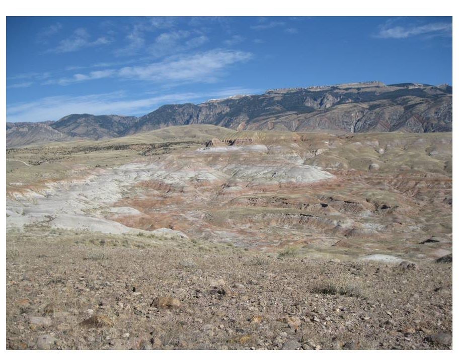
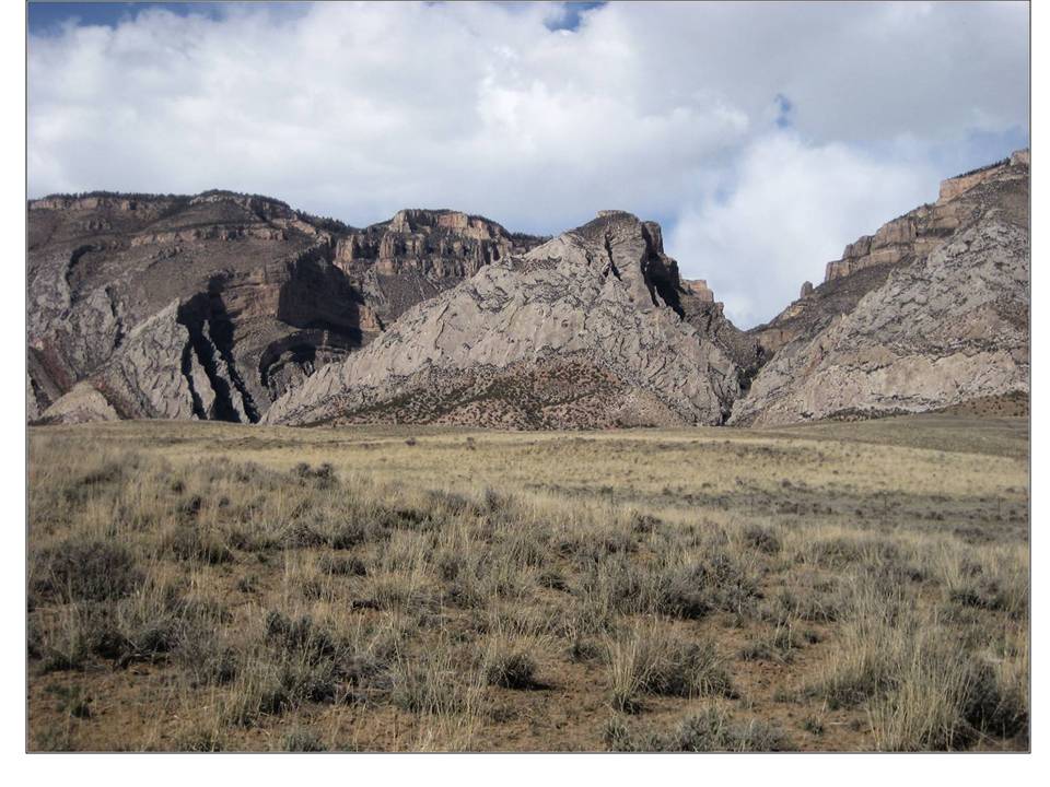
Northeast view of Jurassic Morrison near Tri-Moon and VMNH Dinosaur Quarries
Image by Mark Fisher
Image by Mark Fisher
Wow Factor (2 out of 5 stars):
Geologist Factor (4 out of 5 stars):
Attraction
Scenic and remote Wyoming landscape at foot of Bighorn Mountains where paleontologists have excavated a significant number of dinosaurs. There are no bone quarries open to the public in this area and collecting of bones on federal land is prohibited. The private land is off-limits. If you want a scenic drive in this area, our recommendation is drive up Beaver Creek Road.
Geology of Shell Dinosaur Bone Beds
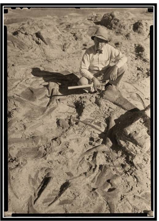
In 1934, Barnum Brown (aka “Mr. Bones”) excavated sauropod bones in the Morrison Formation at the Howe Quarry for the American Museum of Natural History. The quarry is located in the Coyote basin, a sub-basin of the Bighorn Basin, about nine miles north-northwest of Shell. The Sinclair Oil Company funded the bone-finding expedition in Wyoming.
Barnum Brown, in full field sartorial splendor, at Howe Quarry, 1934.
http://thumbs.media.smithsonianmag.com//filer/a0/29/a029d55b-9a33-4aac-8009-7669ee66b619/barnum_toned.jpg__600x0_q85_upscale.jpg
http://thumbs.media.smithsonianmag.com//filer/a0/29/a029d55b-9a33-4aac-8009-7669ee66b619/barnum_toned.jpg__600x0_q85_upscale.jpg
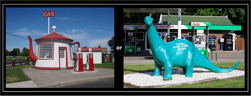
A few years earlier, prisoner number 10,520 was released from the Washington DC jail. This ex-con was the President of Sinclair Oil, Harry Ford Sinclair. He had served six months for contempt of court during the trial for his part in the Teapot Dome scandal. Sinclair Oil began using the “Brontosaur” for marketing their products in 1930 just after his release. They were capitalizing on the dinosaur-craze inspired by the recent discoveries in the West, and no doubt trying to discreetly bury the Teapot scandal from the public memory.
A good image creates demand and sells more product.
Teapot station: https://s-media-cache-ak0.pinimg.com/736x/4c/0a/e6/4c0ae6bb492d8a63026e77e0ec8291a5.jpg
Dino station: https://eagle946.wordpress.com/2015/06/07/pacific-northwest-and-alaska-2015-volume-2/
Teapot station: https://s-media-cache-ak0.pinimg.com/736x/4c/0a/e6/4c0ae6bb492d8a63026e77e0ec8291a5.jpg
Dino station: https://eagle946.wordpress.com/2015/06/07/pacific-northwest-and-alaska-2015-volume-2/
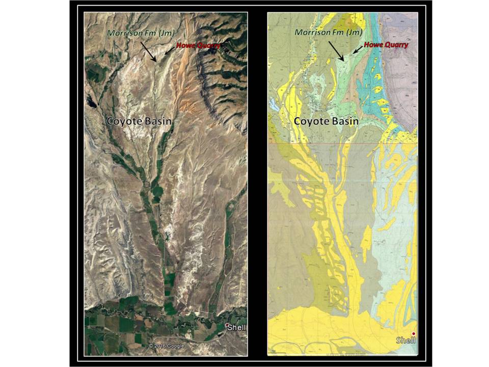
Aerial view and geologic map of Coyote Basin area and the Howe Quarry location. Townships 53 & 54 North, Range 91 West
Aerial View: Google Earth
Geologic Map: N/2: Noggle-Perrin, Karen, 1989, Geologic map of the Leavitt Reservoir Quadrangle, Big Horn County, Wyoming: Wyoming State Geological Survey, Map Series 29, scale 1:24,000 http://www.wsgs.wyo.gov/products/wsgs-1989-ms-29.pdf ; S/2: Manahl, K.A., 1985, Geologic map of the Shell Quadrangle, Wyoming: Wyoming State Geological Survey, Map Series 17, scale 1:24,000 http://www.wsgs.wyo.gov/products/wsgs-1985-ms-17.pdf
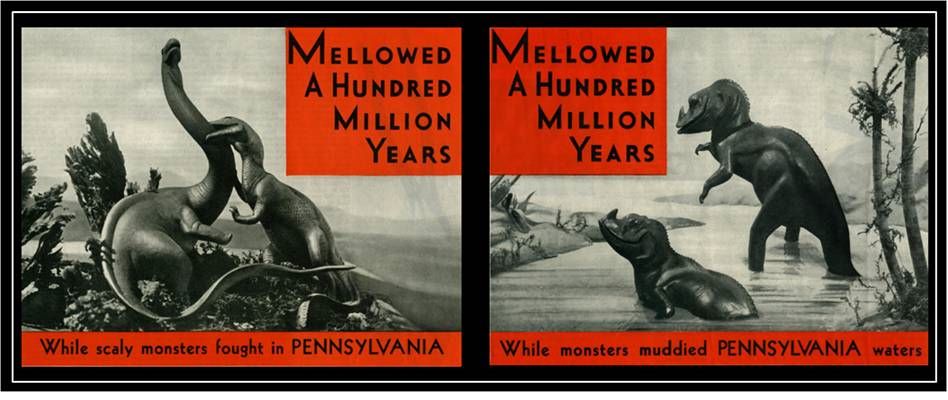
At the time, Sinclair Oil believed the source of their Pennsylvania crude was from rocks deposited during the “Age of Dinosaurs.” The dinosaur logo was trademarked in 1932. The Sinclair exhibit at the 1933-1934 Chicago World’s Fair showcased the world of dinosaurs to the public. It featured life-sized replicas based on Charles R. Knight’s artwork at the American Museum of Natural History (AMNH). The reconstructions reflected the scientific interpretation of the early twentieth century, showing dinosaurs as slow, tail dragging beasts. Stop motion animation of dinosaurs in movies also reflected that view. The Sinclair marketers used ads that promoted the image that oil, like a fine wine or whiskey, improved with ageing.
Sinclair Oil advertisements from the Saturday Evening Post Magazine (left - 1931 and right - 1932).
https://marswillsendnomore.files.wordpress.com/2013/08/sinclair-ads-1931-saturday-evening-post-001.jpg
https://marswillsendnomore.files.wordpress.com/2013/08/sinclair-ads-1931-saturday-evening-post-001.jpg
Left: Buster Keaton’s “Three Ages,” 1923; Center: Sinclair Exhibit, Chicago World’s Fair 1933; Right: RKO’s “King Kong,” 1933
Three Ages Image: https://alchetron.com/Three-Ages
Sinclair Exhibit Image: http://www.clansinclairsc.org/images/sinclairworldsfair1933dinasaur.bmp
King Kong: Courtesy of UC Riverside, California Museum of Photography Image:
http://www.oac.cdlib.org/ark:/13030/kt7p3016d4/?order=2
Three Ages Image: https://alchetron.com/Three-Ages
Sinclair Exhibit Image: http://www.clansinclairsc.org/images/sinclairworldsfair1933dinasaur.bmp
King Kong: Courtesy of UC Riverside, California Museum of Photography Image:
http://www.oac.cdlib.org/ark:/13030/kt7p3016d4/?order=2
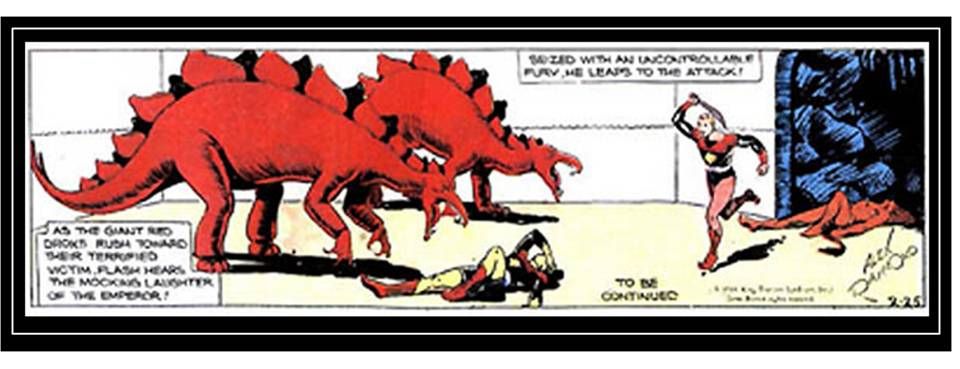
Alex Raymond's Flash Gordon comic strip hero battling dinosaurs on the planet Mongo, February 25, 1934.
Image: https://en.wikipedia.org/wiki/Flash_Gordon#/media/File:Flashgordon22534.jpg
Image: https://en.wikipedia.org/wiki/Flash_Gordon#/media/File:Flashgordon22534.jpg
The movie King Kong premiered in 1933. Its “Skull Island” dinosaurs were also inspired by Knight’s art. In 1934, Flash Gordon appeared in newspaper comics, often in battle with dinosaurian creatures.
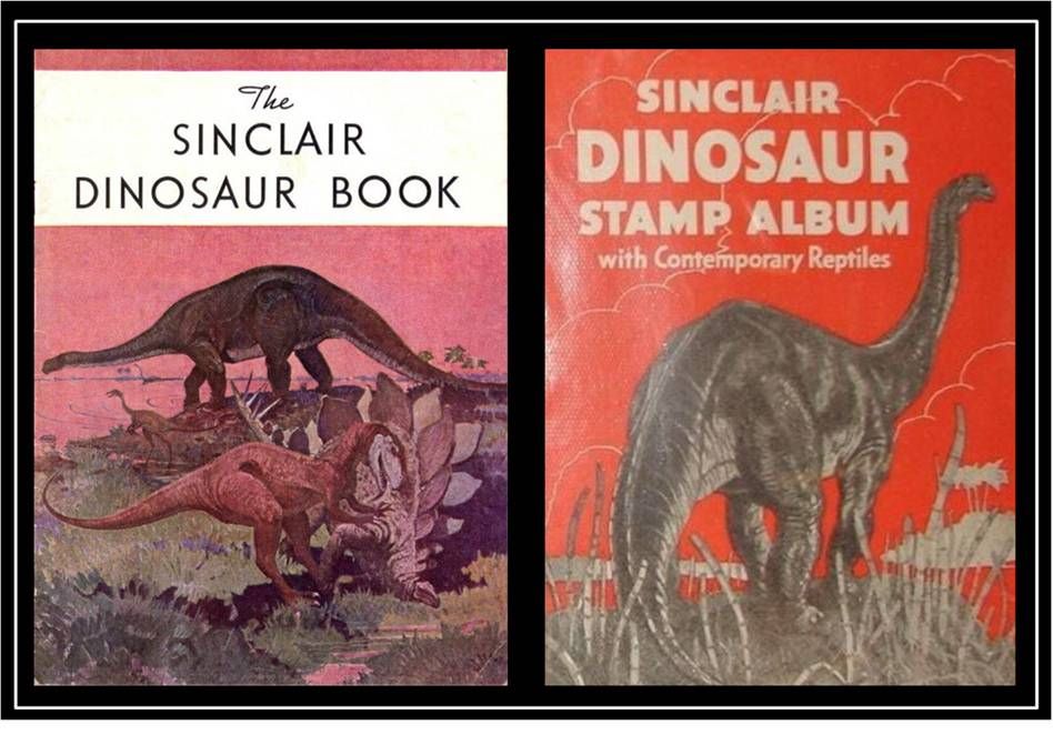
In that same year, Barnum wrote the promotional follow-up to the Chicago Exhibit, “The Sinclair Dinosaur Book.” In 1935 the Sinclair Dinosaur Stamp Album promotion began. Colored dinosaur stamps could be obtained weekly, but only at a Sinclair gas station.
In that same year, Barnum wrote the promotional follow-up to the Chicago Exhibit, “The Sinclair Dinosaur Book.” In 1935 the Sinclair Dinosaur Stamp Album promotion began. Colored dinosaur stamps could be obtained weekly, but only at a Sinclair gas station.
Sinclair Oil dinosaur promotions.
1934 Dino Book Image: http://palaeoblog.blogspot.com/2006/02/1934-worlds-fair-dinos.html
1935 Stamp Album Image: http://aoghs.org/oil-almanac/sinclair-dinosaur/
1934 Dino Book Image: http://palaeoblog.blogspot.com/2006/02/1934-worlds-fair-dinos.html
1935 Stamp Album Image: http://aoghs.org/oil-almanac/sinclair-dinosaur/
This national dinosaur craze was created by the skill of the artists, the imagination of the entertainment industry and the marketing of Sinclair Oil Company. Ultimately, the source were the dinosaur bone beds discovered in the rocks of places like the Coyote Basin of Wyoming.
Jurassic Morrison Formation
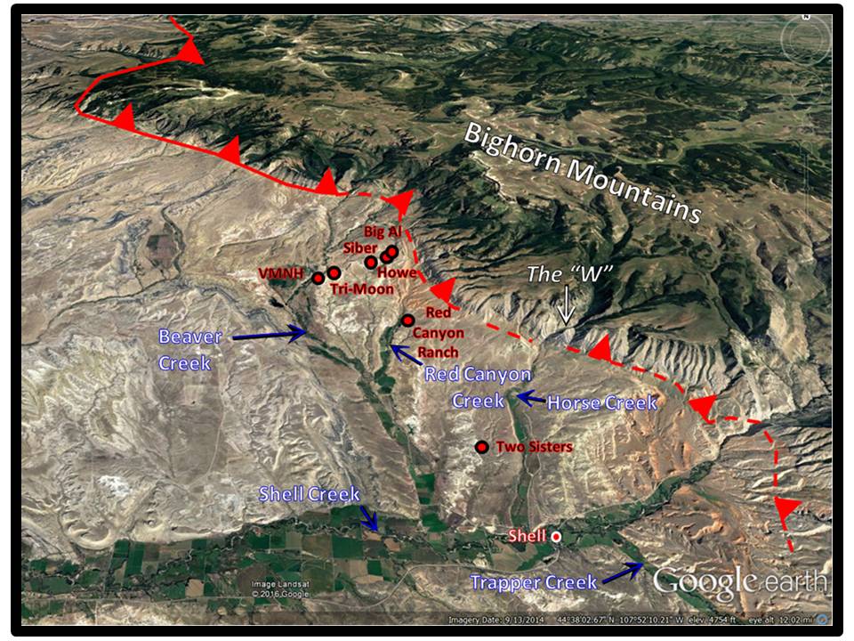
There are seven major dinosaur quarries, each containing several digsites, in the Coyote Basin area. All of these sites are developed in the Morrison Formation that was deposited from 155 to 148 million years ago during the Late Jurassic epoch. The Morrison Formation consists of land sediments deposited in a vast basin that developed east of the rising Western Cordillera.
Northeast view of the Coyote Basin area north of Shell, Wyoming. Locations of major dinosaur quarries shown by red dots. Frontal Bighorn Mountain Thrust shown by red line; solid where it cuts the sedimentary section and dashed where the fault is "blind". Triangles point in direction of the fault surface dip and opposite of thrust motion.
Google Earth Image
Google Earth Image
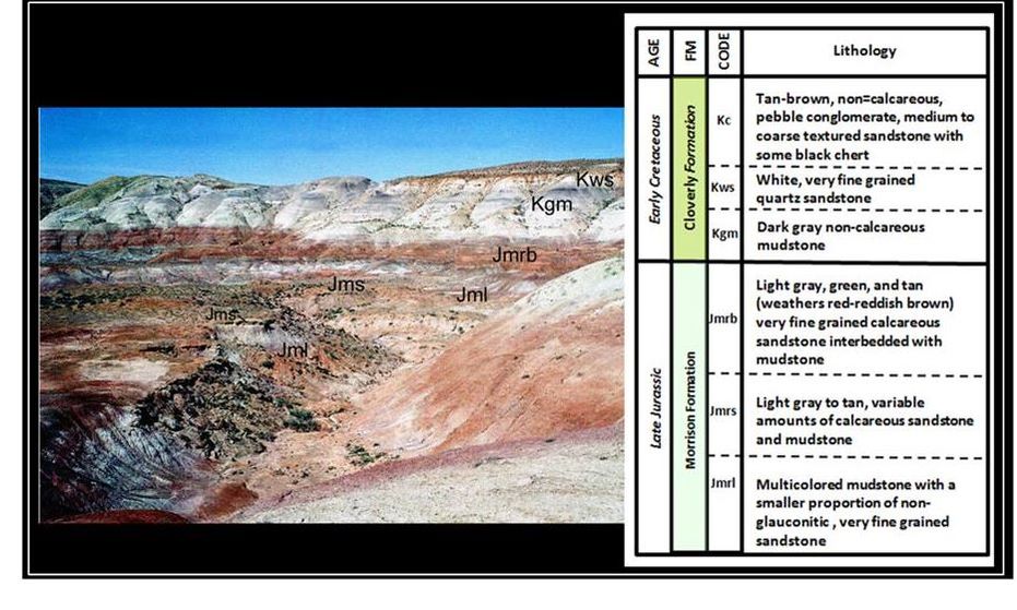
Morrison/Cloverly outcrop on eastern edge of Coyote Basin.
After Robinson, E.S., 2009, Bedrock Geology of the Principal Dinosaur Fossil Sites in the Northeastern Bighorn Basin: Professor Emeritus, Geosciences Department, Virginia Tech Research Associate, Virginia Museum of Natural History webpage, Fig. 3. http://www.itinwriting.com/edsgeology
After Robinson, E.S., 2009, Bedrock Geology of the Principal Dinosaur Fossil Sites in the Northeastern Bighorn Basin: Professor Emeritus, Geosciences Department, Virginia Tech Research Associate, Virginia Museum of Natural History webpage, Fig. 3. http://www.itinwriting.com/edsgeology
Paleogeography of the Morrison depositional basin (brown area within black dashed line) at the beginning of the second stage of Rocky Mountain tectonic evolution. The Morrison basin covered over 600,000 square miles. The Coyote Basin area location is shown by yellow rectangle. Mean current directions of the Morrison Formation are shown by white arrows (after Winslow and Heller, 1987).
Google Earth Image
Google Earth Image
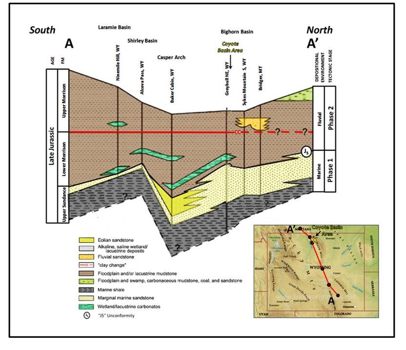
The Morrison was deposited in a system that included river channel and floodplain sediments. The stratigraphic package consists of a lower crossbedded sandstone interbedded with siltstone and mudstone. The upper part is dominated by multicolored brown, red, grey and greenish siltstone and mudstone. Thin sandstone and siltstone beds are also present. The total thickness ranges from 200 to 320 feet thick in the Coyote Basin area.
Regional Morrison outcrop cross section with location of Coyote Basin shown. Clay change marker at change from illite clays to smectite clays. Clay change indicates volcanic ash from Nevada and Southern California that drifted east to northeast during upper Morrison deposition.
After Turner, C.E. and Peterson, F., 2004, Reconstruction of the Upper Jurassic Morrison Formation extinct ecosystem: a synthesis: Sedimentary Geology, Vol. 167, Issue 3-4, Fig. 3, pp. 314-315.
After Turner, C.E. and Peterson, F., 2004, Reconstruction of the Upper Jurassic Morrison Formation extinct ecosystem: a synthesis: Sedimentary Geology, Vol. 167, Issue 3-4, Fig. 3, pp. 314-315.
Howe Quarry
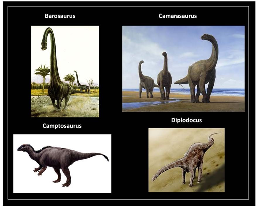
The American Museum of Natural History team of the 1930s conducted the first methodical excavation in this part of the Bighorn Basin. The quarry is located on private property three miles west of the thrust fault margin of the Bighorn Mountains. They recovered skeletal remains of several sauropods including Barosaurus, Camarasaurus, Camptosaurus and Diplodocus. The bones were concentrated in a mud area that had theropod footprints and evidence of scavenging by carnivorous predators like Allosaurus. Gastroliths (gizzard stones) were reported among the bones. Some 4,000 bones were collected and shipped to the AMNH in one six month field season. The quarry was closed and lay dormant for over a half century. A 1940 warehouse fire destroyed most of the original specimens that were in storage in New York.
Kirby Siber of Sauriermuseum Aathal in Zurich, Switzerland obtained paleontology leases on the Howe Ranch property in 1989. Excavation during the first field season was in the old quarry, then moved to the northeast just inside the fence line of the ranch in the second season.
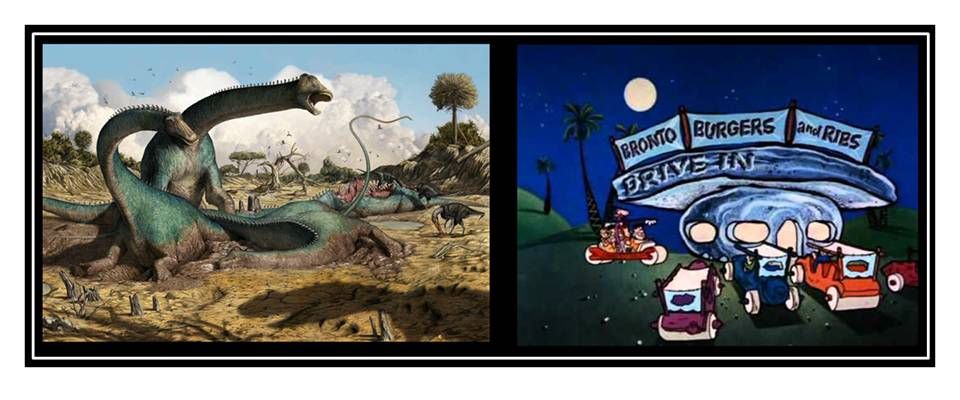
During the Late Jurassic, the Howe Ranch area was a boggy hollow in a river floodplain that experienced seasonal flooding. Sauropods came to drink and perhaps have a mud bath. Several became stuck in the slime and some were washed into the site during floods. Allosaurus wandered in to scavenge at the original “Bronto Burger & Rib” bar (147 million years before Fred Flintstone enjoyed this delicacy).
Bronto Burger and Rib local hotspots. Left: Late Jurassic age Howe Quarry reconstruction; Right: Stone age Bedrock Drive-In
Howe Quarry: National Geographic, Dec.18, 2012: https://www.nationalgeographic.com/science/article/jurassic-boneyard-yields-hidden-dinosaur
Bedrock Drive-In: Flintstones TV Show closing credits: https://www.pinterest.es/pin/36732553182146563/
Howe Quarry: National Geographic, Dec.18, 2012: https://www.nationalgeographic.com/science/article/jurassic-boneyard-yields-hidden-dinosaur
Bedrock Drive-In: Flintstones TV Show closing credits: https://www.pinterest.es/pin/36732553182146563/
Several allosaurs, in turn, became entombed in the same muck. The evidence for this is revealed by theropod tracks amongst the sauropod skeletal remains, teeth and teeth marks on sauropod bones and Allosaurus fossils collected from the area.
Life restorations of Howe Quarry Sauropods.
Barosaurus:
Camarasaurus: http://dinopedia.wikia.com/wiki/Camarasaurus
Camptosaurus: https://upload.wikimedia.org/wikipedia/commons/1/1d/Camptosaurus.jpg
Diplodocus: https://upload.wikimedia.org/wikipedia/commons/thumb/a/aa/Diplodocus_BW.jpg/220px-Diplodocus_BW.jpg
Barosaurus:
Camarasaurus: http://dinopedia.wikia.com/wiki/Camarasaurus
Camptosaurus: https://upload.wikimedia.org/wikipedia/commons/1/1d/Camptosaurus.jpg
Diplodocus: https://upload.wikimedia.org/wikipedia/commons/thumb/a/aa/Diplodocus_BW.jpg/220px-Diplodocus_BW.jpg
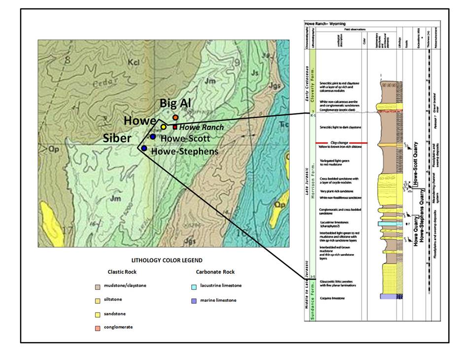
Howe Ranch area quarries: Yellow circle: Howe Quarry; Red circle: Big Al Quarry; Blue Circle: Siber Quarry. Geologic notation: Kcl: Cretaceous Cloverly Fm.; Jm: Jurassic Morrison Fm; Js: Jurassic Sundance Fm; Jgs: Jurassic Gypsum Spring Fm; Trc: Triassic Chugwater Fm. Map shows portions of T54N R91W sections 8, 9, 16 & 17.
Map: Noggle-Perrin, Karen, 1989, Geologic map of the Leavitt Reservoir Quadrangle, Big Horn County, Wyoming: Wyoming State Geological Survey, Map Series 29, scale 1:24,000, http://www.wsgs.wyo.gov/products/wsgs-1989-ms-29.pdf
Outcrop Column: After Tschoppa, E., 2013, Evolution of Diplodocid Sauropod Dinosaurs with Emphasis on Specimens from Howe Ranch, Wyoming (USA), PhD Dissertation, Universidade Nova de Lisboa , Fig 1.2, p. 5. https://run.unl.pt/handle/10362/13248?mode=full
Big Al Quarry
Siber’s team discovered a nearly complete specimen of Allosaurus fragilis in 1991. They later learned that although the dig site was inside the fence line, the fence line was surveyed incorrectly so the site was actually on public land under the jurisdiction of the Bureau of Land Management. The BLM took custody of the specimen in 1991, because vertebrate fossils found on public land are the property of the United States and fall under the stewardship of the BLM. A joint team from the University of Wyoming and Montana State University’s Museum of the Rockies completed the excavation. Big Al is about 26 feet long and eight feet tall at the hip.
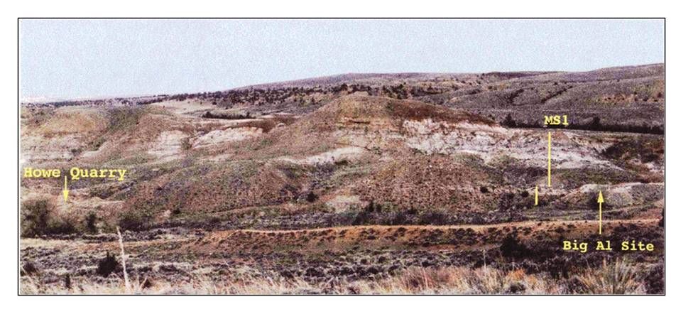
Howe and “Big Al” quarry photo, Coyote Basin. “Big Al” is only about 980 feet from the Howe site, but over 300 feet off the private ranch property. The site had to be surrendered to the BLM because it was on public land.
Laws, R.R., 1996, Paleopathological analysis of a sub-adult Allosaurus fragilis (MOR 693) from the Upper Jurassic Morrison Formation with multiple injuries and infections: M.S. Thesis, Montana State University, Fig. 4, p. 17.
http://scholarworks.montana.edu/xmlui/bitstream/handle/1/7867/31762103103725.pdf?sequence=1
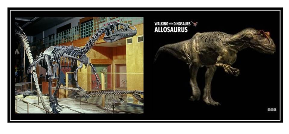
Left: Mounted skeletal cast of “Big Al“ on display at the University of Wyoming Geological Museum; Right: Life restoration from the BBC “Walking with Dinosaurs” series, “The Ballad of Big Al” episode.
Skeleton: http://www.ohio.edu/people/witmerl/images/Allosaurus_BigAl_mount_R1-06741-0005.jpg
Restoration: https://www.pinterest.com/pin/339599628135046362/
Skeleton: http://www.ohio.edu/people/witmerl/images/Allosaurus_BigAl_mount_R1-06741-0005.jpg
Restoration: https://www.pinterest.com/pin/339599628135046362/
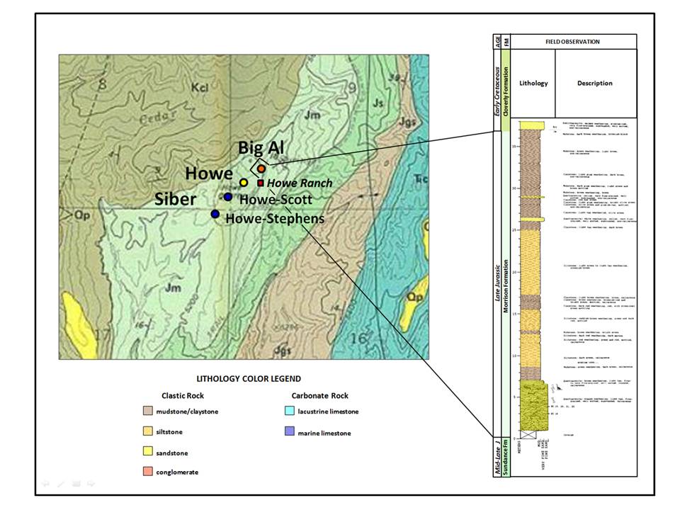
“Big Al” site geologic map and outcrop section “MS1” as seen in quarry photo. Map shows portions of T54N R91W sections 8, 9, 16 & 17.
Map: Noggle-Perrin, Karen, 1989, Geologic map of the Leavitt Reservoir Quadrangle, Big Horn County, Wyoming: Wyoming State Geological Survey, Map Series 29, scale 1:24,000, http://www.wsgs.wyo.gov/products/wsgs-1989-ms-29.pdf
Outcrop Column: After Laws, R.R., 1996, Paleopathological analysis of a sub-adult Allosaurus fragilis (MOR 693) from the Upper Jurassic Morrison Formation with multiple injuries and infections: M.S. Thesis, Montana State University, Plate 1.
http://scholarworks.montana.edu/xmlui/bitstream/handle/1/7867/31762103103725.pdf?sequence=1
Siber Quarries
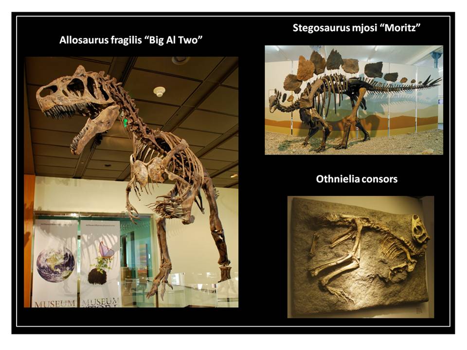
The Swiss team moved 650 feet to the southwest of the original Howe Quarry. The two most productive digs were the Howe-Stephens and the Howe-Scott sites. They excavated numerous specimens including Stegosaurus, Othnielia and an even larger Allosaurus “Big Al Two.”
Fossil from the Siber quarry digs.
“Big Al Two”: Skeletal cast in Houston Museum of Natural History Gift Shop: https://upload.wikimedia.org/wikipedia/commons/5/57/Allosaurus_Big_Al_Two_HMNS.jpg
“Moritz”: Saurier Museum: http://doc.rero.ch/record/209444/files/PAL_E4048.pdf
“Barbara”: Paleontology Museum of Zurich: https://upload.wikimedia.org/wikipedia/commons/5/50/Othnielosaurus_consors.JPG
The quarries were active from 1989 to 2003. The Siber team discontinued work when the land owner sought to clarify legal issues of ownership of the excavated fossils. A chronology of the Siber team’s Greater Howe Quarry area findings is impressive (as listed on Saurier Museum Website)
- 2003 Apatosaurus skeleton as part skeleton
- 2003 huge shoulder blade, 1.80 meters of "Supersaurus”
- 2002 Apatosaurus "Chris" as a partial skeleton
- Received 2002 Stegosaurus "Lilly" excellent
- 1999 sauropods Baby "Toni", unique!
- 1998 div. large fossil Araucaria tree trunks
- 1998 Diplodocus "Ruth" as part skeleton
- 1997 Diplodocus "XL" as part skeleton
- 1996 Allosaurier "Big Al Two" excellent
- 1996 obtained Othnielosaurus "Barbara" excellent
- 1996 Othnielosaurus "Piccolo" as part skeleton
- 1996 Stegosaurus "Victoria" outstanding, with skin preservation
- 1995 Apatosaurus "Max" in very good condition
- 1995 Stegosaurus "Moritz" in very good condition
- 1995 Diplodocus "Aurora" as part skeleton
- 1995 Othnielosaurus "Mini-Max" as a partial skeleton
- 1994 diplodocids "Twin", "Triplo" and "Quattro" as part skeletons
- 1993 Diplodocus "Brösmeli" as part skeleton
- 1992 Camarasaurus "ET" received excellent
- 1991 Allosaurier "Big Al One" was prepared and issued in USA
- 1991 Diplodocus "HQ2" as part skeleton with neck and skull
- 1990 Diplodocus "HQ1" as part skeleton with body and tail
- 1989 first test excavations in the former Steinbruch of Barnum Brown
VMNH
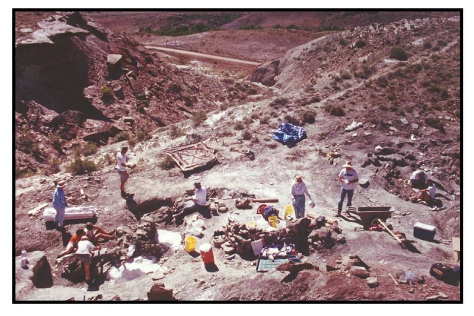
Private commercial collectors opened the Nickopod site in 1998 but transferred the lease to the Virginia Museum of Natural History (VMNH) when the quarry was determined to be on public land. VMNH expanded to the nearby Little Al dig in 2000.
Nickopod digsite at VMNH Quarry. Little Al site is to the right of the image.
Image: Wilborn, B.K., 2001, Two new dinosaur bonebeds from the Late Jurassic Morrison Formation, Bighorn Basin, WY: An analysis of the paleontology and stratigraphy: M.S. Thesis, Virginia Polytechnic Institute and State University, Figs. 11, p. 14. https://theses.lib.vt.edu/theses/available/etd-11152001-170826/unrestricted/etdthesis.pdf
Image: Wilborn, B.K., 2001, Two new dinosaur bonebeds from the Late Jurassic Morrison Formation, Bighorn Basin, WY: An analysis of the paleontology and stratigraphy: M.S. Thesis, Virginia Polytechnic Institute and State University, Figs. 11, p. 14. https://theses.lib.vt.edu/theses/available/etd-11152001-170826/unrestricted/etdthesis.pdf
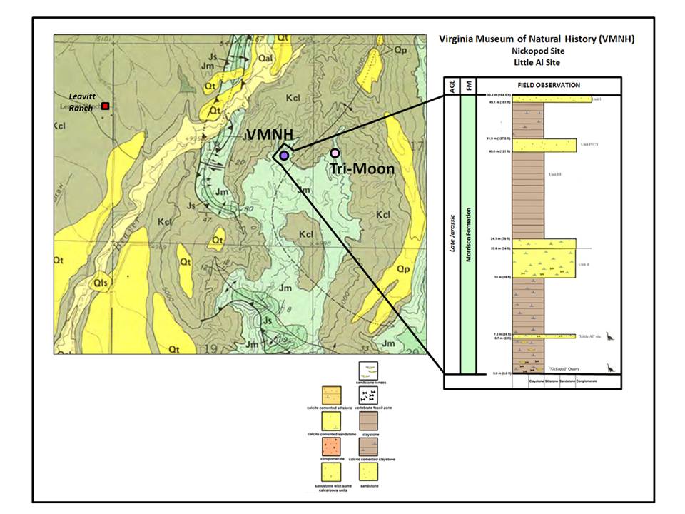
VMNH location site geologic map and outcrop. Map shows portions of T54N R91W sections 17, 18, 19 & 20.
Map: Noggle-Perrin, Karen, 1989, Geologic map of the Leavitt Reservoir Quadrangle, Big Horn County, Wyoming: Wyoming State Geological Survey, Map Series 29, scale 1:24,000, http://www.wsgs.wyo.gov/products/wsgs-1989-ms-29.pdf
Outcrop Column: After Wilborn, B.K., 2001, Two new dinosaur bonebeds from the Late Jurassic Morrison Formation, Bighorn Basin, WY: An analysis of the paleontology and stratigraphy: M.S. Thesis, Virginia Polytechnic Institute and State University, Figs. 9-10, p. 14. https://theses.lib.vt.edu/theses/available/etd-11152001-170826/unrestricted/etdthesis.pdf
Tri-Moon Quarry
The University of the Pacific opened the Tri-Moon quarry in 1992. So far only sauropod skeletal remains have been excavated at the site.
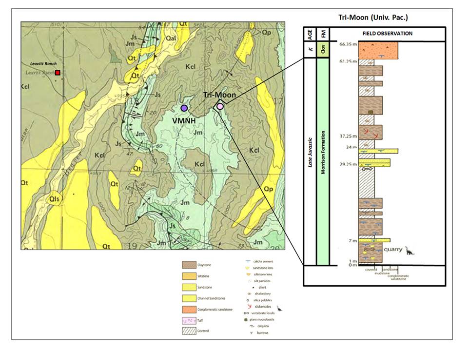
Tri-Moon Quarry location site geologic map and outcrop. Map shows portions of T54N R91W sections 17, 18, 19 & 20.
Map: Noggle-Perrin, Karen, 1989, Geologic map of the Leavitt Reservoir Quadrangle, Big Horn County, Wyoming: Wyoming State Geological Survey, Map Series 29, scale 1:24,000, http://www.wsgs.wyo.gov/products/wsgs-1989-ms-29.pdf
Revised correlation after: Wilborn, B.K., 2008, Paleoecology and Stratigraphy of the Morrison and Cloverly Formations, Bighorn Basin, Wyoming: PhD Dissertation, University of Oklahoma, Chapter 2, Fig. 3, p. 47.
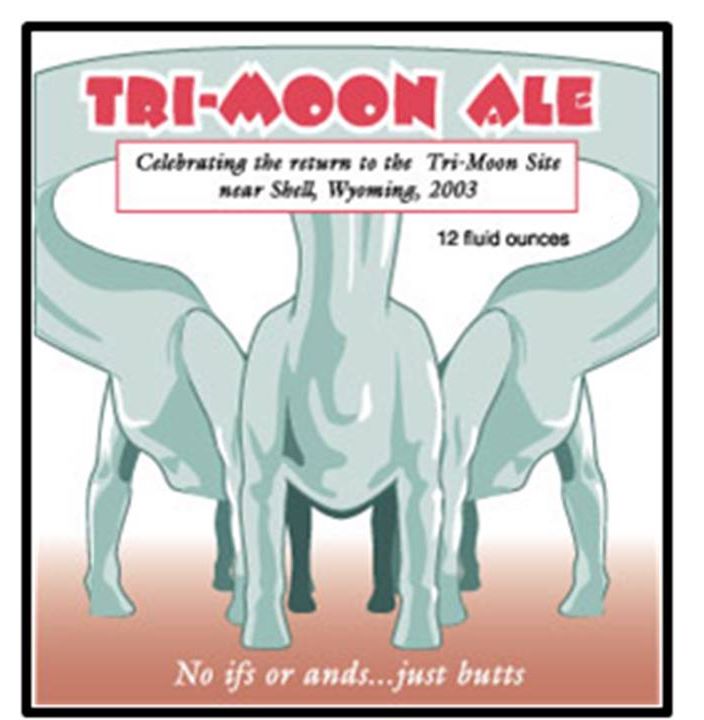
The name for the quarry comes from a comment made by one of the University of the Pacific Team when approaching the digsite. Early in the excavation three separate sauropod pelvic girdles were exposed along the face of the quarry. On hiking into the site a team member remarked on the view “It’s as if they’re mooning us!” So the quarry was christened. Dave Smith commemorated this event in his field work art.
David K. Smith beer label art commemorating the naming of Tri-Moon Quarry.
Red Canyon Ranch Quarry (Bob Simon)
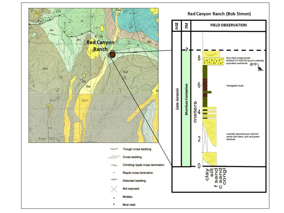
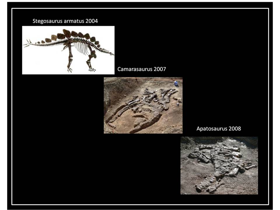
Bob Simon, a retired Chevron petroleum geologist, opened a private commercial quarry about two miles south of the Howe Quarry along Red Canyon Creek drainage. In 2003 his team discovered a nearly complete stegosaur skeleton in the NE NW Section 28, Township 54 North, and Range 91 West. Kirby Siber’s Saurier Museum team helped with the excavation and preparation of specimen. The stegosaurus was named “Sarah” after the ranch owner’s daughter. “Sarah,” renamed “Sophie,” is on display at London’s Natural History Museum. She stands 9.5 feet tall and is 18 feet long. Other specimens excavated include a Camarasaurus in 2007 and an Apatosaurus in 2008.
Red Canyon Ranch Quarry site geologic map and outcrop. Map shows portions of T54N R91W sections 20, 21, 28 & 29.
Map: N/2: Noggle-Perrin, Karen, 1989, Geologic map of the Leavitt Reservoir Quadrangle, Big Horn County, Wyoming: Wyoming State Geological Survey, Map Series 29, scale 1:24,000, http://www.wsgs.wyo.gov/products/wsgs-1989-ms-29.pdf; S/2: Manahl, K.A., 1985, Geologic map of the Shell Quadrangle, Wyoming: Wyoming State Geological Survey, Map Series 17, scale 1:24,000 http://www.wsgs.wyo.gov/products/wsgs-1985-ms-17.pdf
Outcrop: Maidment, S.C.R., Charlotte, C., and Barrett, P.M., 2015, The Postcranial Skeleton of an Exceptionally Complete Individual of Plated Dinosaur Stegosaurus stenops (Dinosauria: Thyreophora) from Upper Jurassic Morrison Formation of Wyoming, U.S.A.: PLoS One, Fig. 4 ,https://journals.plos.org/plosone/article?id=10.1371/journal.pone.0138352
Red Canyon Ranch dinosaur specimens.
Images after Lisa Zago’s education program about the age of dinosaurs
http://dinosauria.biz/discoveries/
Images after Lisa Zago’s education program about the age of dinosaurs
http://dinosauria.biz/discoveries/
Two Sisters Quarry (VMNH)
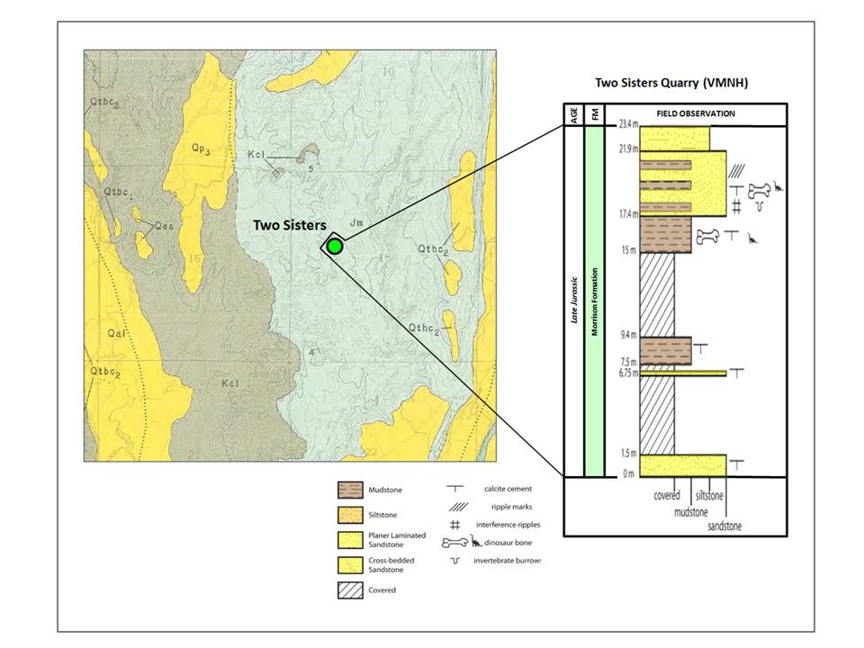
In 2004, the Virginia Museum of Natural History opened the Two Sisters Quarry about three miles north-northwest of Shell. The site is unique in the Coyote Basin area due to the presence of microvertebrates (very small vertebrate fauna) and palynoflora (aggregate of pollen and spores) among the dinosaur remains. The micro fauna and flora indicate an Oxfordian (161-156 million years) age for the site. This is a one to six million year older date than reported for skeletal remains at the six other quarries in Coyote Basin. The fossil remains of fully mature reptiles at Two Sisters are also smaller than those collected elsewhere.
Two Sisters Quarry site geologic map and outcrop. Map shows portions of T53N R91W sections 9, 10, 15, 16, 21 & 22.
Map: Manahl, K.A., 1985, Geologic map of the Shell Quadrangle, Wyoming: Wyoming State Geological Survey, Map Series 17, scale 1:24,000, http://www.wsgs.wyo.gov/products/wsgs-1985-ms-17.pdf
Outcrop: After Wilborn, B.K., 2008, Paleoecology and Stratigraphy of the Morrison and Cloverly Formations, Bighorn Basin, Wyoming: PhD Dissertation, University of Oklahoma, Chapter 5, Fig. 2, p. 235.
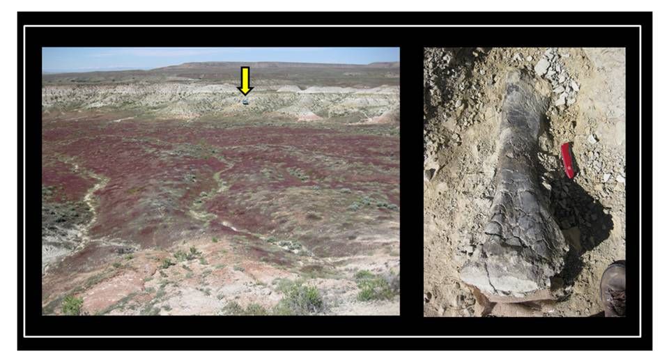
Left: Two Sisters Quarry area showing distinctive badlands topography of the Morrison Formation. Quarry site marked by yellow arrow. Right: A dinosaur tibia being excavated at the quarry.
Both images: Bentley, C, 2011 AGU Blog http://blogs.agu.org/mountainbeltway/2011/10/05/two-sisters/
Both images: Bentley, C, 2011 AGU Blog http://blogs.agu.org/mountainbeltway/2011/10/05/two-sisters/
The Morrison Formation and the dinosaur fossils it contains gives a glimpse through deep time and into the world of 150 million years ago.
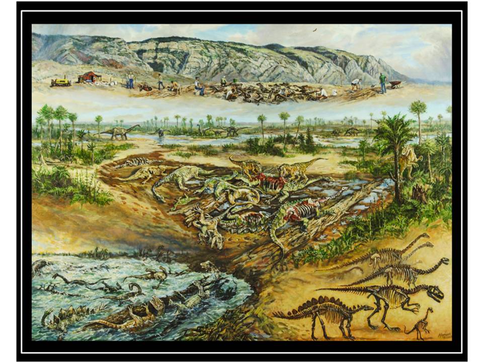
Vision of the Jurassic bone yard.
"Life at the Howe Ranch, once upon a time and now" painting by Mike Kopriva, 2006
Siber, H. and Mockli, U., 2009, The Stegosaurs of the Sauriermuseum Aathal: Sauriermuseum Aathal, Switzerland
http://doc.rero.ch/record/209444/files/PAL_E4048.pdf
"Life at the Howe Ranch, once upon a time and now" painting by Mike Kopriva, 2006
Siber, H. and Mockli, U., 2009, The Stegosaurs of the Sauriermuseum Aathal: Sauriermuseum Aathal, Switzerland
http://doc.rero.ch/record/209444/files/PAL_E4048.pdf
The badlands of Coyote Basin is a place where we can transport to the Jurassic world.
“The Morrison Formation, as a window to the Late Jurassic world, is therefore a look back to time in the history of today’s fauna. It is a snapshot of where we came from - one of the few that is available out of many, many times and places that have changed through vertebrate history. It is a part of our story in a direct sense, and because of that, we can feel a certain connection to the Morrison fauna. We’re part of it too”
John Foster, 2007, Jurassic West: Indiana University Press, p. 325.
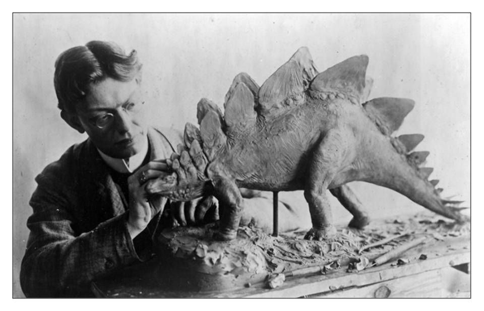
Charles R. Knight (1874-1953) working on a stegosaur model. His vision of the “Age of Dinosaurs” became our vision. Author Richard Milner has subtitled his book on Knight “The artist who saw through time.”
Image: https://en.wikipedia.org/wiki/Charles_R._Knight#/media/File:Charles_R._Knight.jpg
Image: https://en.wikipedia.org/wiki/Charles_R._Knight#/media/File:Charles_R._Knight.jpg
What You Will See at Shell Dinosaur Bone Beds
This is a difficult area to suggest an outing, so the only thing we recommend at this time is a scenic drive up Beaver Creek Road that is open to the public. The federal government won’t let you collect dinosaur fossils on public land and you can’t trespass on private land to collect fossils or even look around. The areas with all the historic dinosaur quarries up Beaver Creek, Cedar Creek, Red Canyon Creek and Horse Creek are on a mixture of private land along the creeks and public land between the creeks in rougher and/or more desolate areas. Many of the roads are private. You would need land ownership maps and/or an app that shows the private versus public land to stay legal. There is also poor cell phone coverage, so you would need to download the data before heading out.
Directions to Beaver Creek Road
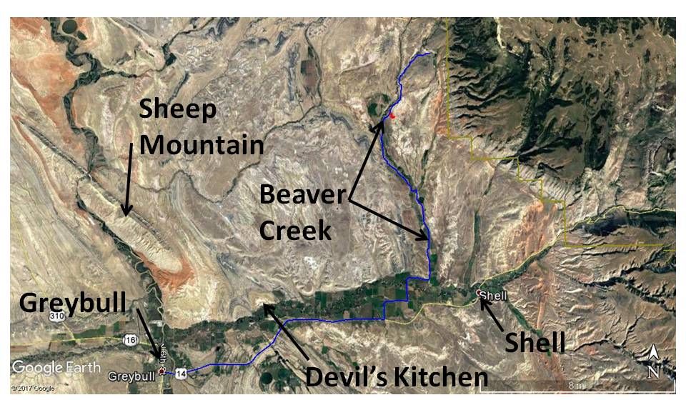
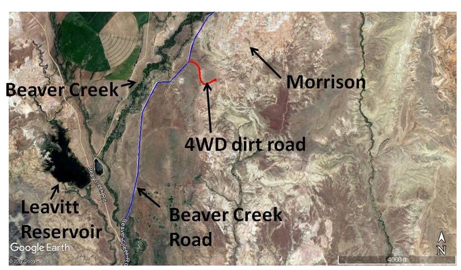
Beaver Creek is accessible with a passenger car. However, the unpaved roads are not recommended when wet. Starting at the only traffic light in downtown Greybull at the intersection of US 14 and US 16-20, head east on US 14 toward Shell and Burgess Junction, 0.2 miles Greybull Museum on right has an impressive giant ammonite that was found in the county (4 foot diameter, 960 lbs), 0.4 miles bridge over Bighorn River, 0.5 miles Greybull Oil Field on right that used an innovative oil mining operation where a long sloping tunnel was driven under the field with multiple holes drilled upward from the tunnel into the field for gravity oil drainage (it probably wins for most unusual way to develop an oil field!) this link has a picture of the tunnel installation https://www.dsiunderground.com/case-studies/2007-info-15/mining-for-oil, 6.8 miles old Shell schoolhouse on left, 7.3 miles Davis Road on left for Devil’s Kitchen, 10.5 miles turn left on Beaver Creek Road, Big Horn County 36, 12.2 miles turn left on Beaver Creek Road, 12.9 miles cross Shell Creek, 18.3 miles bear left, dirt road to right leads to Red Canyon Ranch dinosaur quarry area (private road), 18.4 miles pavement ends, 20.5 slope and ridge on left is Mowry Shale, 21.4 miles road splits, take right fork on Beaver Creek Road, 22.8 miles on right is optional 4WD dirt road for total 0.35 mile, stay left at junction and continue to ridge top and then hike to Morrison outcrops near Tri-Moon and VMNH Quarries (see direction map below, do not pick up any fossils!), 24.9 road splits, take right fork (left is private), 25.6 miles cross creek, 25.9 miles ridges on left and right are Cloverly sandstone, 26.6 miles cattle guard, loading area for ATV riders, road deteriorates shortly beyond this point as it approaches Forest Service boundary. Good spot to stop and turn around.
Directions from Greybull to Beaver Creek drainage
Google Earth
Google Earth
Directions to Morrison outcrops on BLM land near Tri-Moon and VMNH Quarries
Google Earth
Google Earth
The “W” flatiron rises over 1600 feet above Horse Creek on the north (left) and Dry Creek to the south (right). This peak is a good example of Darton’s “great carbonate escarpment.” Notice the monoclonal fold exposed on the north wall of Horse Creek. This fold was formed over the South Beaver Creek blind thrust during the Laramide Orogeny.
Image: Summitpost Image by Tim Schoessler (musicman82), 2010 http://images.summitpost.org/original/614792.jpg
Image: Summitpost Image by Tim Schoessler (musicman82), 2010 http://images.summitpost.org/original/614792.jpg

The material on this page is copyrighted
