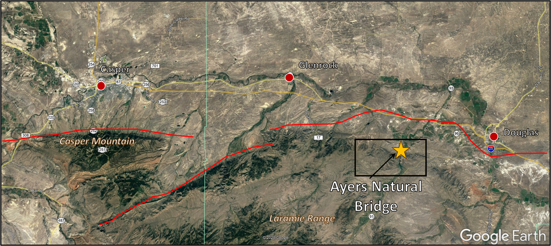
Ayres Natural Bridge and La Prele Creek
Photo by Mark Fisher
Photo by Mark Fisher
Wow Factor (3 out of 5 stars):

Geologist Factor (2 out of 5 stars):

Attraction:
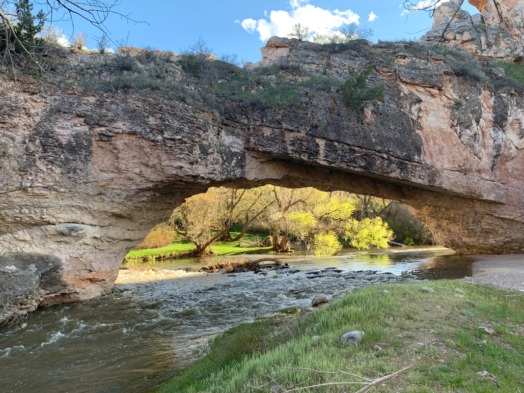
Just a gorgeous and peaceful place with a natural rock bridge spanning La Prele Creek, and lush green grass contrasting against the surrounding red rock cliffs. Certainly worth a stop if you are traveling on the interstate between Casper and Douglas. Area includes several cultural sites of historic and geologic significance near the Emigrant Trails. The Grasslands of the Powder River Basin were a frequent stage for the Indian wars of the American West.
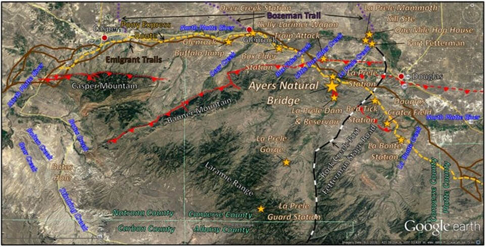
Ayres Natural Bridge area: large gold star. Areas of interest: small gold star. Major faults shown by red lines: tepee on upthrown side, dashed where approximately located and dashed were concealed. Fault: red line with bar and ball on downthrown side. Emigrant trails (Oregon, California, Mormon): solid brown line. Bozeman trail: Purple dotted line. Pony Express route: gold dashed line. Rock Creek to Fort Fetterman stage road: white and black dashed line.
Image: Google Earth
Image: Google Earth
Ayres bridge is a natural 50-foot high, 100-foot long rock structure across La Prele Creek cut by moving water over the centuries. The stream begins on the north slope of the Laramie Range and flows generally northeastward for miles to a confluence with the North Platte River near Fort Fetterman. Ayres bridge is located about two miles south of the Emigrant trails and may have been Wyoming’s first tourist attraction. The feature is reported in written records beginning in 1843. It is found in records of hunting/exploring expeditions, the Donner party, Forty-Niner miners, and the first group of Mormon emigrants in 1847. Ferdinand Hayden described, and William Henry Jackson photographed the feature during the 1870 Wyoming survey.
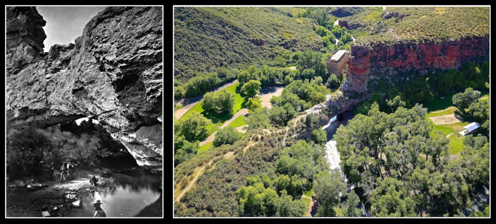
Left: William Henry Jackson’s photo of Ayres Natural Bridge, 1870 Hayden Survey. View is downstream to the north. Right: Ayres Natural Bridge southwest aerial view. Abandoned power station is behind sandstone ridge in center of photograph.
Image: Left: https://www.wyohistory.org/encyclopedia/ayres-natural-bridge. Right: Carey, M., 2018, Ayres Natural Bridge Park; https://www.google.com/maps/uv?hl=en&pb=!1s0x87612d421b855859%3A0x330235500d9ea1e6!3m1!7e115!4shttp%3A%2F%2Fwww.conversecountytourism.com%2Fdo%2Fnatural-bridge%2F!5sayres%20natural%20bridge%20-%20Google%20Search!15sCAQ&imagekey=!1e10!2sAF1QipPZHTE1Mbx87xnLcvIi2hsLu9fjGyOMVnjx54ec&sa=X&ved=2ahUKEwiO4uGD7sndAhWyg-AKHYJwC7kQoiowFnoECAgQCQ.
Image: Left: https://www.wyohistory.org/encyclopedia/ayres-natural-bridge. Right: Carey, M., 2018, Ayres Natural Bridge Park; https://www.google.com/maps/uv?hl=en&pb=!1s0x87612d421b855859%3A0x330235500d9ea1e6!3m1!7e115!4shttp%3A%2F%2Fwww.conversecountytourism.com%2Fdo%2Fnatural-bridge%2F!5sayres%20natural%20bridge%20-%20Google%20Search!15sCAQ&imagekey=!1e10!2sAF1QipPZHTE1Mbx87xnLcvIi2hsLu9fjGyOMVnjx54ec&sa=X&ved=2ahUKEwiO4uGD7sndAhWyg-AKHYJwC7kQoiowFnoECAgQCQ.
History of Ayers Natural Bridge Area
Indians apparently avoided the site due to the “evil spirits” that lived beneath the bridge. This belief arose from a death of a brave from a lightning strike in the area. This gave Euro-Americans a place of refuge during Indian attacks. Early settlers built cabins here and mountain men reportedly lived in nearby caves. Native Americans, however, maintained a long occupation of the basin. The Glenrock buffalo jump shows pre-horse Indians did hunt and butcher just north of the area from A.D. 400 to A.D. 1750. A Paleo-Indian mammoth kill site and camp is located on La Prele Creek northwest of Fort Fetterman dated from at 13,000 years ago.
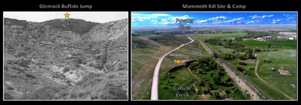
Left: Glenrock buffalo jump is forty-foot north facing escarpment used to kill bison. Geologic abbreviations: Kmvt – Teapot member, Cretaceous Mesaverde Formation; Kmvpb – Powder Butte member, Cretaceous Mesaverde Formation; Kmvp – Parkman member, Cretaceous Mesaverde Formation. Right: La Prele mammoth kill site and camp located at the gold star. View to the east. Image: Left: https://wyoshpo.wyo.gov/index.php/programs/national-register/wyoming-listings/view-full-list/521-glenrock-buffalo-jump; Right: https://phys.org/news/2015-10-human-role-extinction-mammoths-mammals.html.
The route along the North Platte pioneered by trappers in the 1820s and 1830s developed into the Emigrant Trails. The California trail was in use by 1834. The Oregon trail became popular after 1843. The Mormon trail was used from 1846 to 1868. The Bozeman trail connected these earlier routes to the Montana gold fields through cutoffs between present-day Casper and Douglas. The trailed was active from 1863 to 1868 across the grassland of the western Powder River basin.
This was the traditional Crow Indian hunting grounds, formally recognized by the 1851 Fort Laramie Treaty. The Lakota Sioux and their allies aggressively forced the Crow into Montana by 1860. The Sioux and their allies (Cheyenne and Arapahoe) did not approve of the presence of the Bozeman Trail and became increasingly belligerent over the perceived trespass by the emigrants, miners and army. Indians attacked the Kelly-Larimer wagon train in July 1864 along Little Box Elder Creek. Four men were killed, two women and two children were taken prisoner, and the wagons were looted of supplies and horses. One of the women was killed, trying to escape. All five of the deceased are buried two miles west of Natural Bridge Road.
Deer Creek Station was the site of Joseph Bissonette’s trading post at the confluence of Deer Creek and the North Platte River. It also served as a mail and stage stop along the Emigrant trail. With Indian hostilities on the rise, the army established a post adjacent to the station to protect the telegraph and travelers on the trails in 1862. The Kelly-Larimer attack led to Bissonette abandoning the trading post in the Fall of 1864. Two battles took place near Deer Creek Station in 1865. The Indians burned down the empty station in 1866.
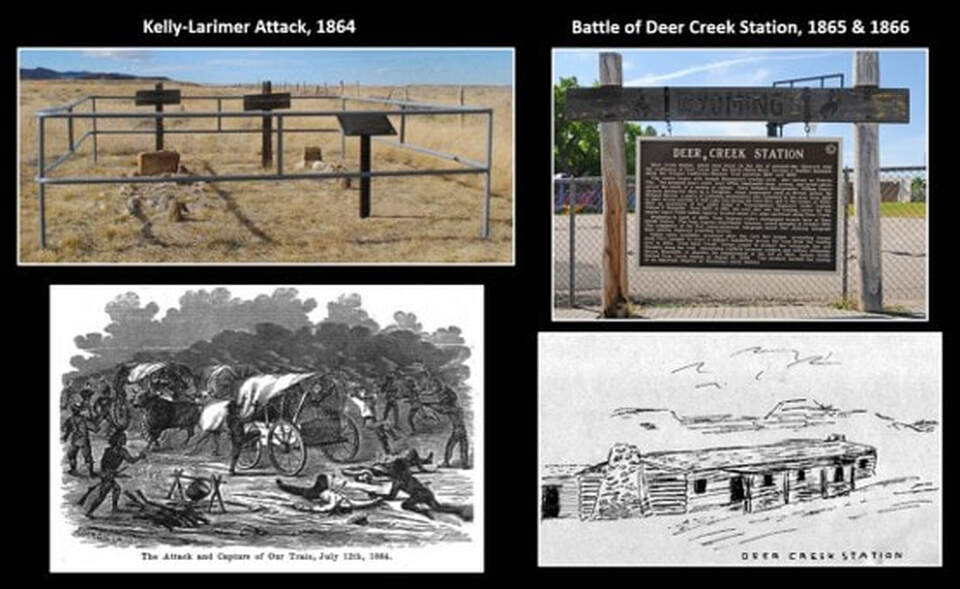
Left: Kelly-Larimer Wagon Attack gravesite and artist’s interpretation. Right: Deer Creek Station marker and artist’s reconstruction.
Image: Left Top: After Brown, R., Photo in https://www.wyohistory.org/encyclopedia/attack-kelly-larimer-wagon-train, Left Bottom: Kelly, F., 1891, My Captivity Among the Sioux Indians, Third Edition, Figure preceding Chapter 2; https://books.google.com/books?id=wn8TAAAAYAAJ&printsec=frontcover&source=gbs_ge_summary_r&cad=0#v=onepage&q&f=true. Right Top: After Mays, K., https://www.deseret.com/2019/4/10/20670507/picturing-history-deer-creek-and-glenrock-wyoming#interpretive-panel-identifying-the-site-of-rock-in-the-glen-near-present-day-glenrock-wyoming, Right Bottom: https://www.legendsofamerica.com/wp-content/uploads/2018/01/deercreekstation.jpg.
Image: Left Top: After Brown, R., Photo in https://www.wyohistory.org/encyclopedia/attack-kelly-larimer-wagon-train, Left Bottom: Kelly, F., 1891, My Captivity Among the Sioux Indians, Third Edition, Figure preceding Chapter 2; https://books.google.com/books?id=wn8TAAAAYAAJ&printsec=frontcover&source=gbs_ge_summary_r&cad=0#v=onepage&q&f=true. Right Top: After Mays, K., https://www.deseret.com/2019/4/10/20670507/picturing-history-deer-creek-and-glenrock-wyoming#interpretive-panel-identifying-the-site-of-rock-in-the-glen-near-present-day-glenrock-wyoming, Right Bottom: https://www.legendsofamerica.com/wp-content/uploads/2018/01/deercreekstation.jpg.
U.S. Army ordered a punitive expedition against the Sioux, Arapahoe, and Cheyenne living in the Black Hills in 1865 that became known as the Powder River War. In 1865, the Cheyenne attacked settlers, wagons, and solders throughout the Platte River drainage as revenge for the Massacre at Sand Creek, Colorado in late 1864. By spring of 1865, the Sioux and Cheyenne combined forces to attack all Euro-Americans (civilian or military) that trespass their territory. This was followed by Red Cloud’s War ignited in 1866 that ended with the second Fort Laramie Treaty of 1868. Fort Fetterman was built in 1867 on the south bluff of the North Platte River. The fort was an important staging area for the Indian wars in the Powder River Basin.
The One Mile Hog Ranch was built north of the river from the fort as an entertainment venue in 1880. It gained a reputation as the “rowdiest, roughest and most dangerous red-light establishment in Wyoming.” It moved across the river to Fetterman City after the Army abandoned the post in 1882. Sheriff Malcom Campbell closed the establishment in 1885. Alfred Packer, a notorious fugitive, was recognized at the One Mile by a fellow patron and soon captured by Sheriff Campbell at a nearby hideout.
The One Mile Hog Ranch was built north of the river from the fort as an entertainment venue in 1880. It gained a reputation as the “rowdiest, roughest and most dangerous red-light establishment in Wyoming.” It moved across the river to Fetterman City after the Army abandoned the post in 1882. Sheriff Malcom Campbell closed the establishment in 1885. Alfred Packer, a notorious fugitive, was recognized at the One Mile by a fellow patron and soon captured by Sheriff Campbell at a nearby hideout.
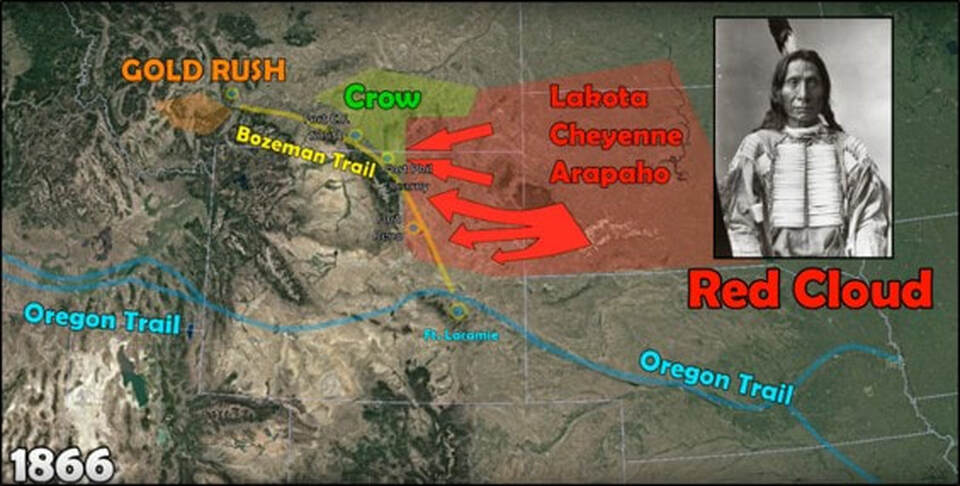
Red Cloud’s War, 1866-1868. Red Cloud was probably the most successful Native American leader in all conflicts of Indians with the U.S. Army.
Image: After 2W1C S03E10: Red Cloud's War; https://www.youtube.com/watch?v=CtdvsdlyAUI.
Image: After 2W1C S03E10: Red Cloud's War; https://www.youtube.com/watch?v=CtdvsdlyAUI.
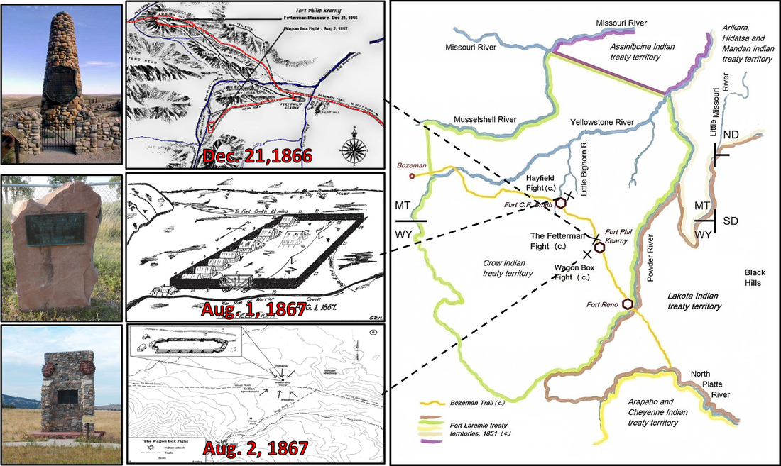
Monuments of major battles in Red Cloud’s War. Map showing the major battlefields of Red Cloud's War, 1866-1868, and the relevant Indian territories as described in the Treaty of Fort Laramie (1851).
Image: Top Left: http://exploringoffthebeatenpath.com/Battlefields/FettermanMassacre/index.html; Middle Left: https://www.nps.gov/bica/learn/historyculture/hayfield-fight.htm and https://en.wikipedia.org/wiki/Hayfield_Fight#/media/File:Hayfield_Fight_site_1.jpg;
Bottom Left: https://www.wyohistory.org/encyclopedia/wagon-box-fight-1867;
Right: https://en.wikipedia.org/wiki/Red_Cloud%27s_War.
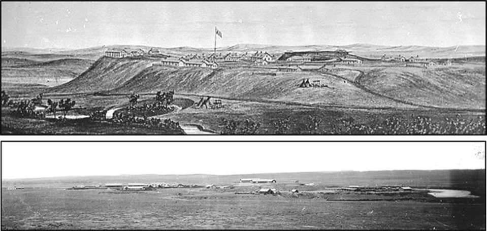
Top: Anton Schonborn sketch of Forth Fetterman, 1879. View is from the southwest. Bottom: Detail of William Henry Jackson photo of Fort Fetterman, 1872.
Image: Top: https://upload.wikimedia.org/wikipedia/commons/6/66/Fort_Fetterman%2C_Converse_County%2C_Wyoming._View_from_southwest._-_NARA_-_516877.jpg. Bottom: After https://upload.wikimedia.org/wikipedia/commons/c/c5/Fort_Fetterman%2C_named_for_William_I._Fetterman%2C_killed_at_Fort_Phil_Kearny_Massacre._Established_in_1867._It_marks..._-_NARA_-_516865.jpg
Image: Top: https://upload.wikimedia.org/wikipedia/commons/6/66/Fort_Fetterman%2C_Converse_County%2C_Wyoming._View_from_southwest._-_NARA_-_516877.jpg. Bottom: After https://upload.wikimedia.org/wikipedia/commons/c/c5/Fort_Fetterman%2C_named_for_William_I._Fetterman%2C_killed_at_Fort_Phil_Kearny_Massacre._Established_in_1867._It_marks..._-_NARA_-_516865.jpg
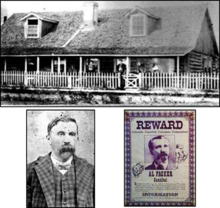
Top: One Mile Hog Ranch in former Fort Fetterman hospital. Bottom Left: Sheriff Malcolm “Old Grizzly” Campbell. Bottom Right: Alfred “Colorado Cannibal” Packer.
Image: Top & Bottom Left: Brown, L.K., 1995, The Hog Ranches of Wyoming: Liquor, Lust, & Lies Under Sagebrush Skies (Kindle Version), Loc. 592 & 670 of 838. Bottom Right: https://www.facebook.com/TodayInHorrorHistory/photos/a.1442157599438544/2019188805068751/?type=3&theater.
Image: Top & Bottom Left: Brown, L.K., 1995, The Hog Ranches of Wyoming: Liquor, Lust, & Lies Under Sagebrush Skies (Kindle Version), Loc. 592 & 670 of 838. Bottom Right: https://www.facebook.com/TodayInHorrorHistory/photos/a.1442157599438544/2019188805068751/?type=3&theater.
With the end of the Indian wars in the basin and the building of the transcontinental railroad through Wyoming the area was officially opened for settlement by Euro-Americans by the late 1870’s. Large cattle herds soon grazed on the open range grasslands of the basin by 1883 replacing the bison.
Geology of Ayres Natural Bridge
Ayres Natural Bridge is a geologic feature at the southern margin of the Powder River Basin. The Casper Mountain–Laramie Range are major uplifts elevated on north-bounding thrust faults about 60 million years ago. East La Prele Anticline (ELA) is one of several northwest-trending folds developed on back thrusts of the north bounding fault.
Aerial view of Ayres Natural Bridge. Rectangle shows zoomed in aerial image location. Also shown are locations of geologic cross sections B to B' and C to C'.
Image: Google Earth.
Image: Google Earth.
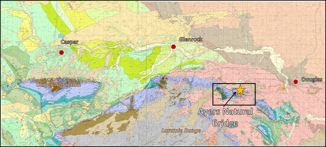
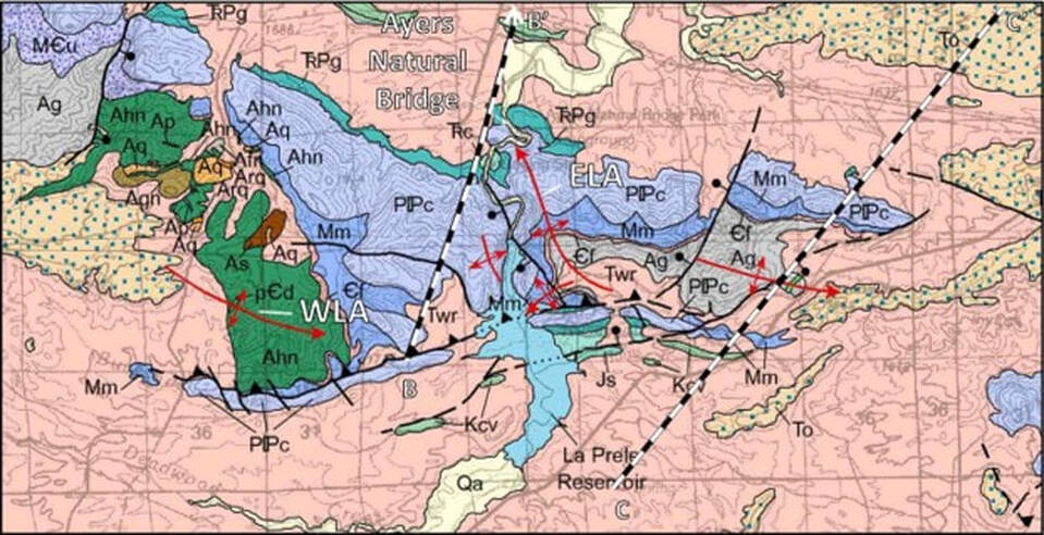
Geologic map of Ayres Natural Bridge area. Rectangle is location of zoomed in geologic map shown below. Abbreviations: ELA – East La Prele Anticline, WLA – West La Prele Anticline, SM – Sheep Mountains.
Image: After Hunter, John, Ver Ploeg, A.J., and Boyd, C.S., 2005, Geologic map of the Casper 30' x 60' quadrangle, Natrona and Converse counties, Wyoming: Wyoming State Geological Survey Map Series 65, scale 1:100,000; https://www.wsgs.wyo.gov/products/wsgs-2005-ms-65.pdf and McLaughlin, J.F., and Ver Ploeg, A.J., 2008, Geologic map of the Douglas 30' x 60' quadrangle, Converse and Platte counties, Wyoming: Wyoming State Geological Survey Map Series 83, scale 1:100,000: https://www.wsgs.wyo.gov/products/wsgs-2008-ms-83.pdf
Image: After Hunter, John, Ver Ploeg, A.J., and Boyd, C.S., 2005, Geologic map of the Casper 30' x 60' quadrangle, Natrona and Converse counties, Wyoming: Wyoming State Geological Survey Map Series 65, scale 1:100,000; https://www.wsgs.wyo.gov/products/wsgs-2005-ms-65.pdf and McLaughlin, J.F., and Ver Ploeg, A.J., 2008, Geologic map of the Douglas 30' x 60' quadrangle, Converse and Platte counties, Wyoming: Wyoming State Geological Survey Map Series 83, scale 1:100,000: https://www.wsgs.wyo.gov/products/wsgs-2008-ms-83.pdf
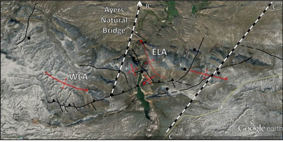
Close up aerial image of Ayres Natural Bridge area. Abbreviations: ELA – East La Prele anticline; WLA – West La Prele anticline.
Image: After Google Earth.
Image: After Google Earth.
Close up geologic map of Ayres Natural Bridge area.
Image: After Hunter, John, Ver Ploeg, A.J., and Boyd, C.S., 2005, Geologic map of the Casper 30' x 60' quadrangle, Natrona and Converse counties, Wyoming: Wyoming State Geological Survey Map Series 65, scale 1:100,000; https://www.wsgs.wyo.gov/products/wsgs-2005-ms-65.pdf and McLaughlin, J.F., and Ver Ploeg, A.J., 2008, Geologic map of the Douglas 30' x 60' quadrangle, Converse and Platte counties, Wyoming: Wyoming State Geological Survey Map Series 83, scale 1:100,000: https://www.wsgs.wyo.gov/products/wsgs-2008-ms-83.pdf
Image: After Hunter, John, Ver Ploeg, A.J., and Boyd, C.S., 2005, Geologic map of the Casper 30' x 60' quadrangle, Natrona and Converse counties, Wyoming: Wyoming State Geological Survey Map Series 65, scale 1:100,000; https://www.wsgs.wyo.gov/products/wsgs-2005-ms-65.pdf and McLaughlin, J.F., and Ver Ploeg, A.J., 2008, Geologic map of the Douglas 30' x 60' quadrangle, Converse and Platte counties, Wyoming: Wyoming State Geological Survey Map Series 83, scale 1:100,000: https://www.wsgs.wyo.gov/products/wsgs-2008-ms-83.pdf
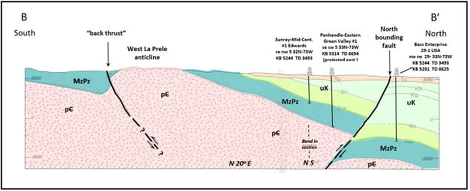
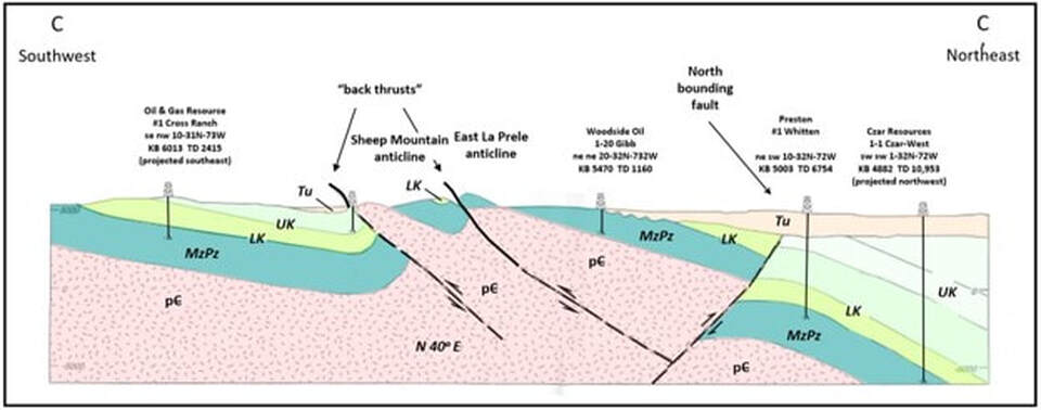
Structural cross sections BB’ and CC’ showing back thrust development from north bounding fault. Geologic formation abbreviations: Tu – Tertiary undifferentiated; UK – Upper Cretaceous; LK – Lower Cretaceous; MzPz – Mesozoic and Paleozoic; pC - Precambrian. Location of cross sections shown above on geology map.
Image: After Blackstone, D.L., Jr., 1996, Structural geology of the Laramie Mountains, southeastern Wyoming and northeastern Colorado: Wyoming State Geological Survey Report of Investigations 51, 28 p., 3 pls., scale 1:500,000, Plate 3, Cross section BB’ and CC’; https://www.wsgs.wyo.gov/products/wsgs-1996-ri-51.pdf.
Image: After Blackstone, D.L., Jr., 1996, Structural geology of the Laramie Mountains, southeastern Wyoming and northeastern Colorado: Wyoming State Geological Survey Report of Investigations 51, 28 p., 3 pls., scale 1:500,000, Plate 3, Cross section BB’ and CC’; https://www.wsgs.wyo.gov/products/wsgs-1996-ri-51.pdf.
Ayres Natural Bridge is an erosional feature called a meander loop cutoff. It is formed when the stream undercuts a channel through the neck of a bend in the stream. It developed during the post-glacial period of the Cenozoic carving its way through Pennsylvanian Casper Formation. The Casper, eastern facies of the Tensleep Formation, consists of fine- to medium-grained, massive to thin bedded, cross bedded sandstones, calcareous sandstones, and limestones. deposited in coastal and marine environment. The red color is from the iron mineral hematite (Fe2O3).
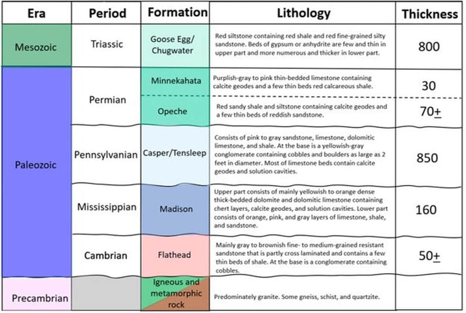
Generalized stratigraphic column of outcrops at Ayres Natural Bridge and canyon area.
Image: After Rapp, J.R., 1953, Reconnaissance of the Geology and Ground-water Resources of the La Prele Area Converse county, Wyoming: U.S. Geological Survey Circular 243, Table 1, p. 10-11; https://pubs.usgs.gov/circ/1953/0243/report.pdf.
Image: After Rapp, J.R., 1953, Reconnaissance of the Geology and Ground-water Resources of the La Prele Area Converse county, Wyoming: U.S. Geological Survey Circular 243, Table 1, p. 10-11; https://pubs.usgs.gov/circ/1953/0243/report.pdf.
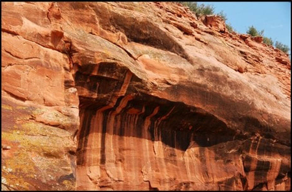
Casper Formation near Ayres Natural Bridge.
Image: St. John, J., 2011; https://flickr.com/photos/jsjgeology/49145364357/in/photostream/.
Image: St. John, J., 2011; https://flickr.com/photos/jsjgeology/49145364357/in/photostream/.
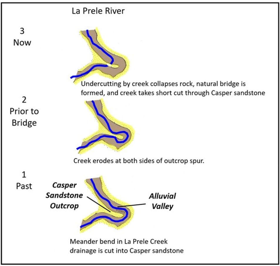
Time sequence maps showing formation of Ayres Natural Bridge by La Prele Creek erosion
Image: After Lageson, D.R. and Spearing, D.R., 1988, Roadside Geology of Wyoming, Revised 2nd Edition. Fig. on p.36.
Image: After Lageson, D.R. and Spearing, D.R., 1988, Roadside Geology of Wyoming, Revised 2nd Edition. Fig. on p.36.
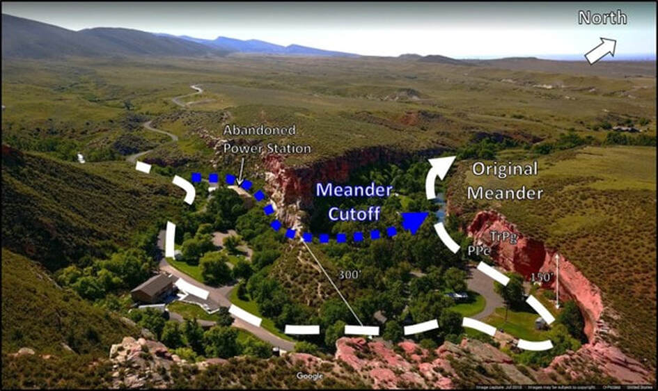
Meander loop cutoff at Ayres Natural Bridge. White dashed line is original stream path. Blue small dotted line shows present stream flow that eroded through the Casper Formation. View is to the west-northwest.
Image: After Carey, M., 2018, Ayres Natural Bridge, Wyoming: Website via Google.
Image: After Carey, M., 2018, Ayres Natural Bridge, Wyoming: Website via Google.
La Prele Mammoth Kill Site
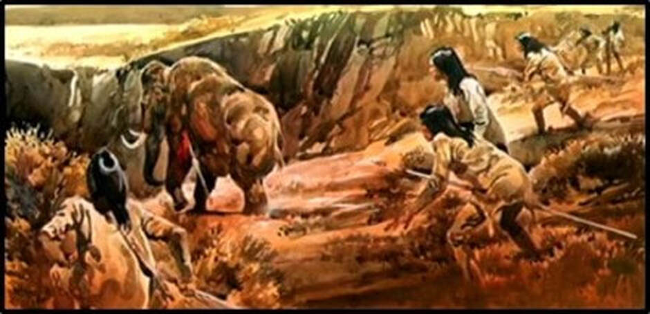
The red ocher and chert tools recovered at the Clovis-age (12,000-11,000 years before present) mammoth kill site and camp indicated long distance communication between hunter gather groups from South Pass and Hartville Uplift areas. Red ocher is the name for the mineral hematite. Clovis culture had two sources for the mineral found at the La Prele site: quarries near Rawlins or Hartville. Rawlins Red Quarry is over 100 miles upstream along the North Platte River. The Hartville Powars II Quarry is about 50 miles downstream along the North Platte River. This migration along the North Platte – Sweetwater corridor by the first Paleo Indians in North America dates use of this the human transportation route at about 12,000 years.
Clovis culture mammoth hunt.
Image: After Todd Surovell at Saturday U - Wyoming’s First Humans at an Ice Age Mammoth Kill Site
Mar 8, 2018; https://www.youtube.com/watch?v=dEhUSfwOA1w.
Image: After Todd Surovell at Saturday U - Wyoming’s First Humans at an Ice Age Mammoth Kill Site
Mar 8, 2018; https://www.youtube.com/watch?v=dEhUSfwOA1w.
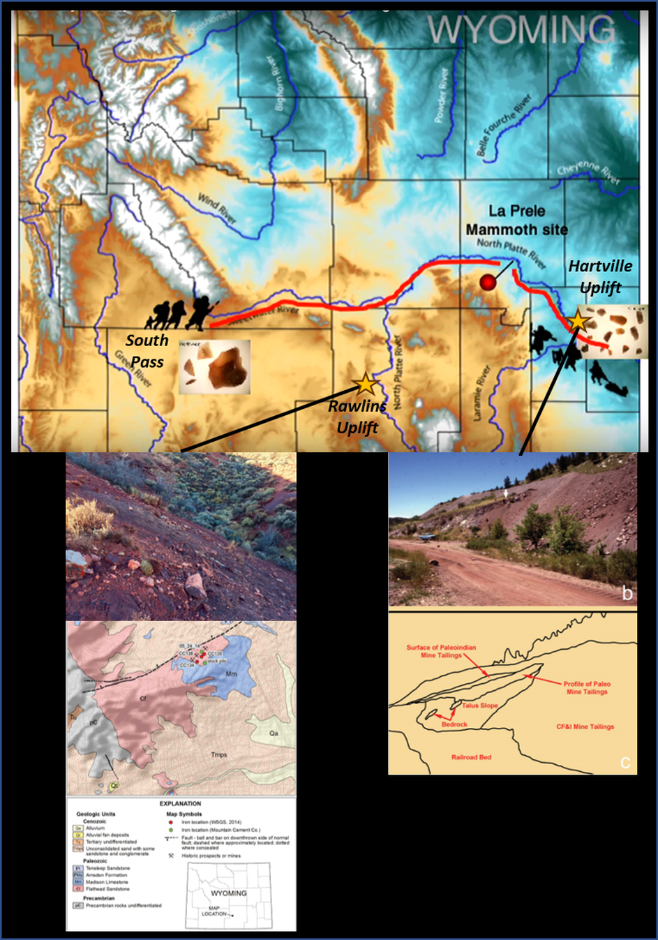
Long distance communication and cooperation at La Prele Mammoth Kill Site and Camp. Geochemistry sourcing of chert tools and red ocher suggest Rawlins (112 miles southwest) and Hartville (53 miles southeast) clans meet to share mammoth kill at the La Prele site.
Image: Top: After Todd Surovell at Saturday U - Wyoming's First Humans at an Ice Age Mammoth Kill Site Mar 8, 2018; https://www.youtube.com/watch?v=dEhUSfwOA1w; Bottom Left: Rawlins Red Site After Sutherland, W.M., and Cola, E.C., 2015, Iron resources in Wyoming: Wyoming State Geological Survey Report of Investigations 67, Fig 19-20, p. 56 & 58; http://sales.wsgs.wyo.gov/iron-resources-in-wyoming-2015/; Bottom Right: Powers II Site: George C. Frison, George M. Zeimens, Spencer R. Pelton, Danny N. Walker, Dennis J. Stanford, and Marcel Kornfeld, 2018, Further Insights into Paleoindian use of the Powars II Red Ocher Quarry (48PL330), Wyoming: American Antiquity 83 (3), Fig. 2b,c, p. 4; https://www.researchgate.net/publication/324617153_Further_Insights_into_Paleoindian_use_of_the_Powars_II_Red_Ocher_Quarry_48PL330_Wyoming.
Image: Top: After Todd Surovell at Saturday U - Wyoming's First Humans at an Ice Age Mammoth Kill Site Mar 8, 2018; https://www.youtube.com/watch?v=dEhUSfwOA1w; Bottom Left: Rawlins Red Site After Sutherland, W.M., and Cola, E.C., 2015, Iron resources in Wyoming: Wyoming State Geological Survey Report of Investigations 67, Fig 19-20, p. 56 & 58; http://sales.wsgs.wyo.gov/iron-resources-in-wyoming-2015/; Bottom Right: Powers II Site: George C. Frison, George M. Zeimens, Spencer R. Pelton, Danny N. Walker, Dennis J. Stanford, and Marcel Kornfeld, 2018, Further Insights into Paleoindian use of the Powars II Red Ocher Quarry (48PL330), Wyoming: American Antiquity 83 (3), Fig. 2b,c, p. 4; https://www.researchgate.net/publication/324617153_Further_Insights_into_Paleoindian_use_of_the_Powars_II_Red_Ocher_Quarry_48PL330_Wyoming.
La Prele Dam
The privately owned La Prele Water District constructed a dam in 1909 in the canyon about one mile upstream of Ayres Natural Bridge. The abandoned pumphouse/power station near the natural bridge was built from a failed attempt to expand the irrigation district into the Glenrock area. The dam is located on the north flank of an anticline in the Madison Formation. Beds are tilted 15-30 degrees north. La Prele Creek has carved an 800-foot canyon into the anticline since Oligocene time (34-23 million years ago). It is called a superimposed stream that are common in canyons of Wyoming (e.g. Wind River, Big Horn, Shoshone, Flaming Gorge, etc.).
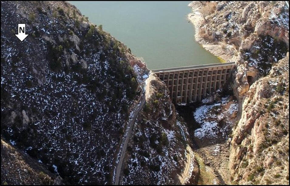
South aerial view of La Prele Dam across north-dipping Madison Limestone, Converse County, Wyoming.
Image: Stimson, C., 2019, Study to focus on La Prele Dam stability as irrigation district plans rehabilitation: Douglas Budget; http://www.douglas-budget.com/news/article_a3b4d374-16cb-11ea-9cec-1f228da92bb2.html#tncms-source=block-contextual-fallback.
Image: Stimson, C., 2019, Study to focus on La Prele Dam stability as irrigation district plans rehabilitation: Douglas Budget; http://www.douglas-budget.com/news/article_a3b4d374-16cb-11ea-9cec-1f228da92bb2.html#tncms-source=block-contextual-fallback.
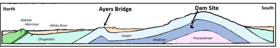
Generalized cross section along La Prele Creek showing position of dam and Ayres Natural Bridge.
Image: After Knight, S.H., 1936, Geology of the La Prele dam site, Converse County, Wyoming: Geological Survey of Wyoming [Wyoming State Geological Survey] Miscellaneous Publication, Fig. 1, p. 2; http://sales.wsgs.wyo.gov/geology-of-the-la-prele-dam-site-converse-county-wyoming-1936/ .
Image: After Knight, S.H., 1936, Geology of the La Prele dam site, Converse County, Wyoming: Geological Survey of Wyoming [Wyoming State Geological Survey] Miscellaneous Publication, Fig. 1, p. 2; http://sales.wsgs.wyo.gov/geology-of-the-la-prele-dam-site-converse-county-wyoming-1936/ .
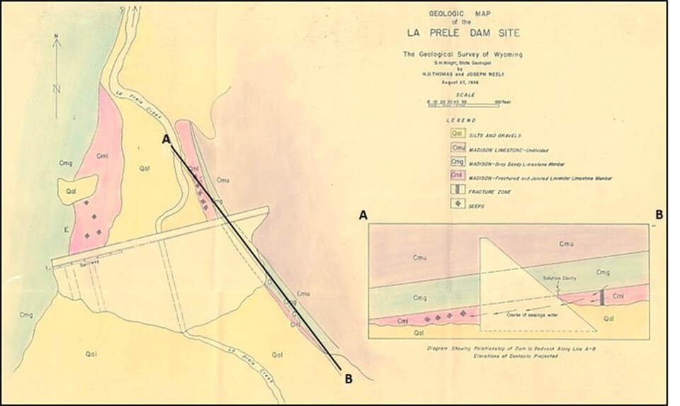
Geologic map of La Prele dam site.
Image: After Knight, H.D., and Neeley, J., 1936, Geologic Map of the La Prele dam site, in: Geological Survey of Wyoming [Wyoming State Geological Survey] Miscellaneous Publication, Map Pocket; http://sales.wsgs.wyo.gov/geology-of-the-la-prele-dam-site-converse-county-wyoming-1936/.
Image: After Knight, H.D., and Neeley, J., 1936, Geologic Map of the La Prele dam site, in: Geological Survey of Wyoming [Wyoming State Geological Survey] Miscellaneous Publication, Map Pocket; http://sales.wsgs.wyo.gov/geology-of-the-la-prele-dam-site-converse-county-wyoming-1936/.
Big Muddy Oil Field
The 1916 oil discovery of Big Muddy Field near Glenrock produced high quality oil from several Cretaceous reservoirs including the Shannon, Wall Creek, Frontier, Muddy and Dakota Formations. The first sub-granite production in the Rocky Mountain Region was found in 1971 at True Hakalo #31-6, nw ne 6-32N-75W. The discovery of oil was the fuel that enabled the economic growth of the communities from Casper to Douglas.
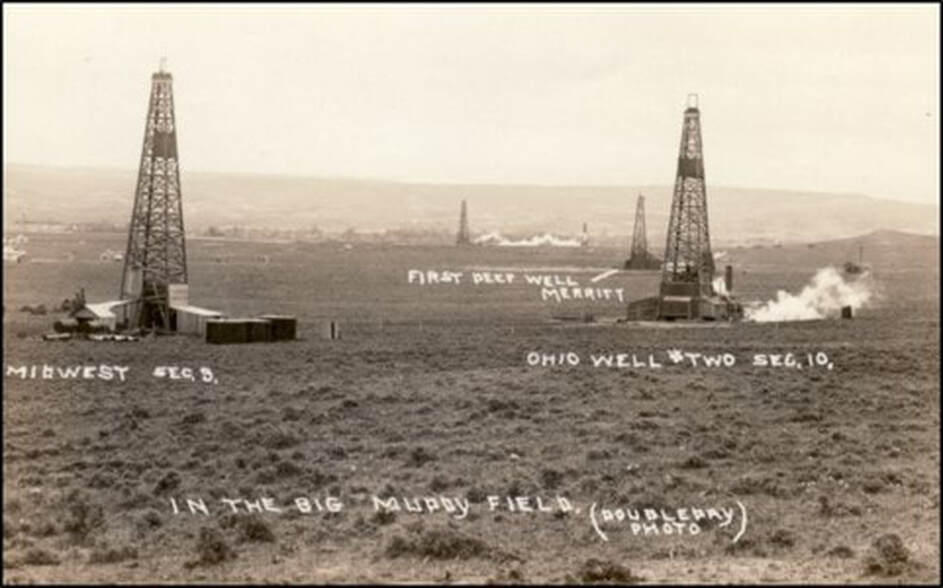
Cable-tool rigs drill for oil in the Big Muddy Field area circa 1918.
Image: https://aoghs.org/stocks/wyoming-prairie-oil-gas-company/.
Image: https://aoghs.org/stocks/wyoming-prairie-oil-gas-company/.
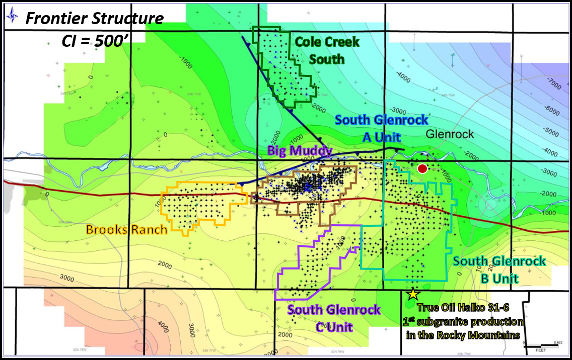
Generalized Frontier structure map, Big Muddy Complex. Productive reservoirs: Shannon, Niobrara, Frontier, Upper Muddy, Lower Muddy, Dakota, and Lakota. The first subgranite production in the Rocky Mountains is shown by yellow star, South Glenrock Field
Image: After Milliken, M., 2019, Development of Glenrock Area Fields, Converse County, Wyoming: American Association of Petroleum Geologists Search and Discovery Article #20467; http://www.searchanddiscovery.com/pdfz/documents/2019/20467milliken/ndx_milliken.pdf.html
Image: After Milliken, M., 2019, Development of Glenrock Area Fields, Converse County, Wyoming: American Association of Petroleum Geologists Search and Discovery Article #20467; http://www.searchanddiscovery.com/pdfz/documents/2019/20467milliken/ndx_milliken.pdf.html
Directions to Ayres Natural Bridge
Ayres Natural Bridge is about 20 minutes from Douglas. Take 1-25 west from Douglas for about 11 miles and exit 151. Then head south on Natural Bridge Road (County Route 13) about five miles to the Ayres Natural Bridge Park run by Converse County. Opens in the spring and closes in the fall. No dogs allowed in park. Bring a picnic lunch and enjoy this tranquil place!

The material on this page is copyrighted