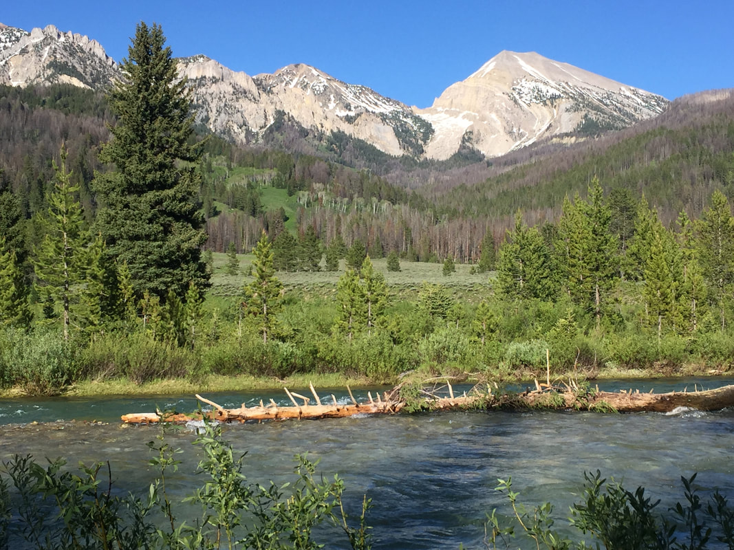
Granite Creek and Paleozoic sedimentary rocks in the Gros Ventre Range
Photo by Mark Fisher
Photo by Mark Fisher
Wow Factor (3 out of 5 stars):
Geologist Factor (3 out of 5 stars):
Attraction
For at least 11,000 years native Americans travelled through the Gros Ventre Range area for summer hunting of big game. European fur trappers came for the pelts of beaver from the Spring thaw till the annual rendezvous in early Summer. Today, tourists and locals come to enjoy the spectacular landscape, wildlife and hot springs in all seasons.
Geology of the Gros Ventre Range
The Gros Ventre Range (pronounced Grow-vont) is located west of the Continental Divide between the Wind River Range (east) and the Teton Mountains (northwest) and the Hoback Range (west). They cover an area of 270 square miles with peaks between 10,000 to 11,500-foot elevation. At 11,270 feet high, Doubletop Peak is the highest mountain in the range. The Laramide orogeny created the range about 50 million years ago in the Early Tertiary. The ancestral Teton-Gros Ventre uplifted a northwest-trending asymmetric arch over the surrounding basins by reverse faults rooted in basement rock on southwest flank. The total amount of movement on the faults is about 5-10 miles. The uplift faulted and folded an 8,000-foot section of Phanerozoic sedimentary rock over the basement. The western portion of the ancestral range underwent greater erosion and was down dropped by the Teton Normal Fault that was superimposed across the ancestral structure in the Neogene between six to nine million years ago.
The ancestral Gros Ventre Range included a portion of the southern portion of the Teton Range. The western portion of the range underwent greater erosion than the eastern part. The Neogene Teton Fault is superimposed across the western portion of the older Laramide structure. Today the eastern portion of the Gros Ventre Range terminates adjacent to the Elk Preserve.
Image: After Mills, J.P. and Huntoon, P., 1989, Foreland Structure and Karstic Ground water circulation in the Eastern Gros Ventre Range: Research Project Technical Completion Report (USGS G-1600, Project No. 02), Fig. 7, p. 9; http://library.wrds.uwyo.edu/wrp/wrp.html.
Image: After Mills, J.P. and Huntoon, P., 1989, Foreland Structure and Karstic Ground water circulation in the Eastern Gros Ventre Range: Research Project Technical Completion Report (USGS G-1600, Project No. 02), Fig. 7, p. 9; http://library.wrds.uwyo.edu/wrp/wrp.html.
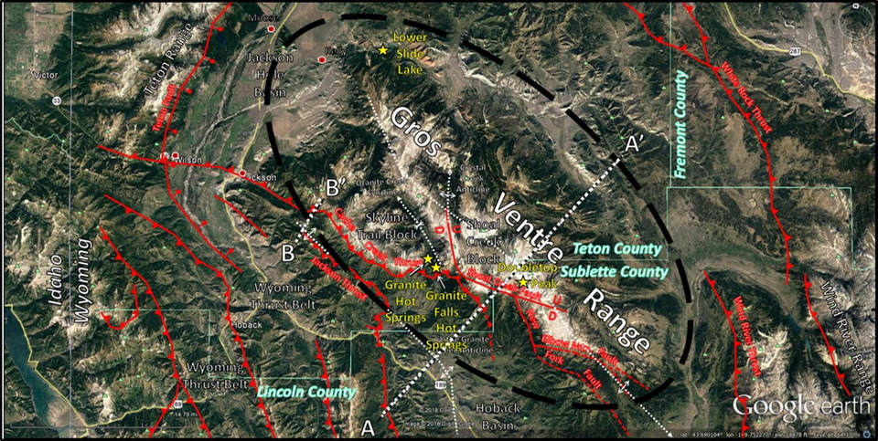
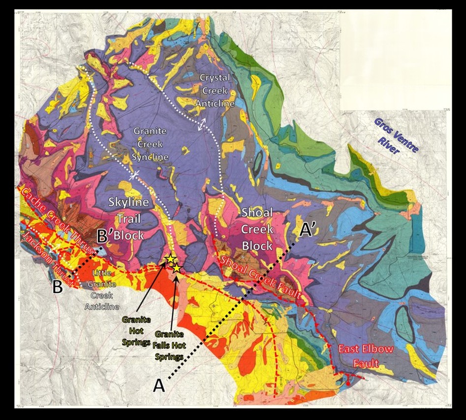
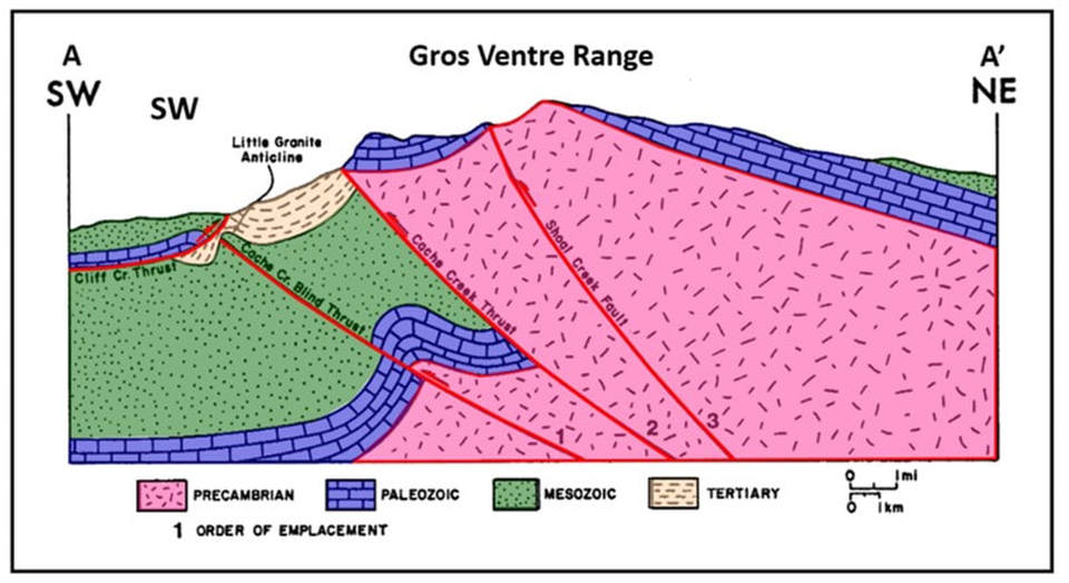
The Gros Ventre Range is divided into two asymmetric structural blocks separated by the Granite Creek syncline: Skyline Trail block on the Cache Creek Thrust (west) and the Shoal Creek Block (east) on the Shoal Creek fault. Their structure and order of emplacement are shown on cross section AA’. The Cache Creek vertical displacement is 700-800 feet and the Shoal Creek is 1,000-2,000 feet.
Structural features in the Gros Ventre Range area. Dashed ellipse shows main area under discussion. Faults shown by red lines: solid: fault at surface, dashed: inferred. Thrust faults have sawteeth on the upthrown blocks. Normal faults: U: upthrown block, D: downthrown block or stick and ball on the downthrown block. Anticlines and synclines shown by white dashed lines. Structural cross sections AA’ and BB’ are shown with white dotted lines. The Cache Creek Fault extends into Idaho but is buried by sediments.
Image: Google Earth, Data: Lageson, D.L., 1987, Laramide Uplift of the Gros Ventre Range and Implications for the Origin of the Teton Fault, Wyoming, Fig. 1, p. 80 and Fig. 2, p. 82; Mills, J.P. and Huntoon, P., 1989, Foreland Structure and Karstic Ground water circulation in the Eastern Gros Ventre Range: Research Project Technical Completion Report (USGS G-1600, Project No. 02), Fig. 2, p. 4 and Fig. 12, p. 16;http://library.wrds.uwyo.edu/wrp/89-02/89-02.pdf.
Image: Google Earth, Data: Lageson, D.L., 1987, Laramide Uplift of the Gros Ventre Range and Implications for the Origin of the Teton Fault, Wyoming, Fig. 1, p. 80 and Fig. 2, p. 82; Mills, J.P. and Huntoon, P., 1989, Foreland Structure and Karstic Ground water circulation in the Eastern Gros Ventre Range: Research Project Technical Completion Report (USGS G-1600, Project No. 02), Fig. 2, p. 4 and Fig. 12, p. 16;http://library.wrds.uwyo.edu/wrp/89-02/89-02.pdf.
Geologic map of Gros Ventre Range area. Location of hot springs near Cache Creek Thrust are displayed by yellow stars. Structural cross sections AA’ and BB’ are shown with black dotted lines.
Image: after Simons, F.S., Love, J.D.,Keefer, W.R., Harwood, D.S.,Kulik, D.M., and Bieniewski, C.L., 1988, Mineral resources of the Gros Ventre Wilderness Study Area, Teton and Sublette Counties, Wyoming: U.S. Geological Survey Bulletin 1591, Plate 1; https://pubs.er.usgs.gov/publication/b1591.
Image: after Simons, F.S., Love, J.D.,Keefer, W.R., Harwood, D.S.,Kulik, D.M., and Bieniewski, C.L., 1988, Mineral resources of the Gros Ventre Wilderness Study Area, Teton and Sublette Counties, Wyoming: U.S. Geological Survey Bulletin 1591, Plate 1; https://pubs.er.usgs.gov/publication/b1591.
Gros Ventre Range structural cross section AA’. Number shows order of emplacement. Location on image below.
Image: After Mills, J.P. and Huntoon, P., 1989, Foreland Structure and Karstic Ground water circulation in the Eastern Gros Ventre Range: Research Project Technical Completion Report (USGS G-1600, Project No. 02), Fig. 2, p. 4 and Fig. 12, p. 16; http://library.wrds.uwyo.edu/wrp/89-02/89-02.pdf.
Image: After Mills, J.P. and Huntoon, P., 1989, Foreland Structure and Karstic Ground water circulation in the Eastern Gros Ventre Range: Research Project Technical Completion Report (USGS G-1600, Project No. 02), Fig. 2, p. 4 and Fig. 12, p. 16; http://library.wrds.uwyo.edu/wrp/89-02/89-02.pdf.
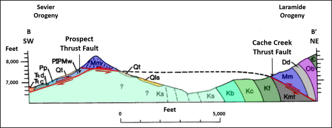
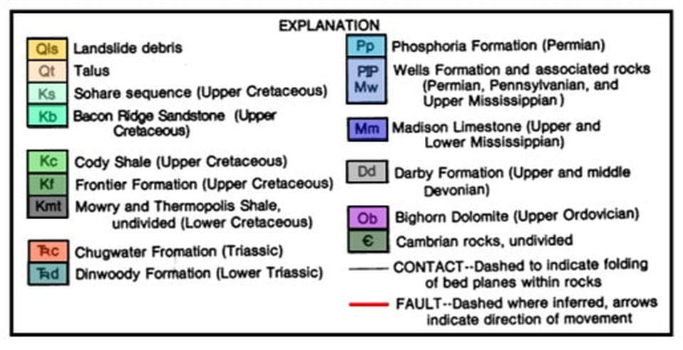
Structural cross section BB’ near the boundary between the structures created by the Sevier Orogeny (southwest, Prospect Thrust Fault) and Laramide Orogeny (northeast, Cache Creek Thrust Fault). Location shown on fault trend image (above), geologic map (above), and area landslide image (below).
Image: After U.S. Department of Interior, Geological Survey and U.S. Department of Agriculture, Forestry Service, 1981, Draft Cache Creek-Bear Thrust Environmental Impact Statement: Proposed Oil and Gas Drilling Near Jackson, Teton County, Wyoming, Fig. II-2b, p. II-6; https://books.google.com/books?id=8zvxAAAAMAAJ&pg=SL252-PA5&lpg=SL252-PA5&dq=gros+ventre+range+seismic+data&source=bl&ots=AsR2xS-73r&sig=itwOVhSE3Us9z0st7G6Z-56i9xs&hl=en&sa=X&ved=2ahUKEwjqv9Pv09TeAhUIO60KHSGwA-YQ6AEwE3oECAMQAQ#v=onepage&q=gros%20ventre%20range%20seismic%20data&f=true
Image: After U.S. Department of Interior, Geological Survey and U.S. Department of Agriculture, Forestry Service, 1981, Draft Cache Creek-Bear Thrust Environmental Impact Statement: Proposed Oil and Gas Drilling Near Jackson, Teton County, Wyoming, Fig. II-2b, p. II-6; https://books.google.com/books?id=8zvxAAAAMAAJ&pg=SL252-PA5&lpg=SL252-PA5&dq=gros+ventre+range+seismic+data&source=bl&ots=AsR2xS-73r&sig=itwOVhSE3Us9z0st7G6Z-56i9xs&hl=en&sa=X&ved=2ahUKEwjqv9Pv09TeAhUIO60KHSGwA-YQ6AEwE3oECAMQAQ#v=onepage&q=gros%20ventre%20range%20seismic%20data&f=true
Stratigraphy of the Gros Ventre Range
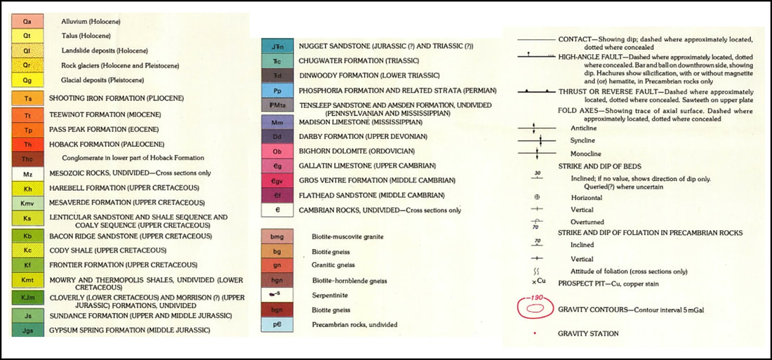
The stratigraphic units exposed in the range are mainly folded Paleozoic and Mesozoic rocks on the upthrown blocks. Upper Cretaceous and younger units are found in the footwall to the southwest of the faults.
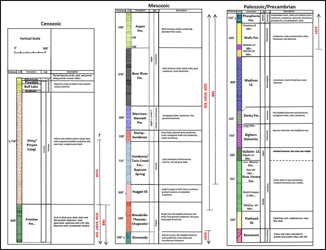
Stratigraphic column for the Gros Ventre Range region. The range of strata involved in lands is shown by a vertical dashed line. Abbreviations: BRS: Bacon Ridge Slides, DCCS: Dry Cottonwood Creek Slides, GCSLS: Goosewing Creek and Soda Lake Slides, LGVS: Lower Gros Ventre Slide, SCS: Slate Creek Slides, UGVS: Upper Gros Ventre Slide.
Image: After Nelson, V.E. and Church, V., 1943, Critical Structures of the Gros Ventre and Northern Hoback Ranges, Wyoming: TheJournal of Geology Vol. 51, No. 3, Fig. 2, p. 145; https://www.jstor.org/stable/i30068283.
Image: After Nelson, V.E. and Church, V., 1943, Critical Structures of the Gros Ventre and Northern Hoback Ranges, Wyoming: TheJournal of Geology Vol. 51, No. 3, Fig. 2, p. 145; https://www.jstor.org/stable/i30068283.
Granite Hot Springs, Granite Falls and Granite Falls Hot Springs
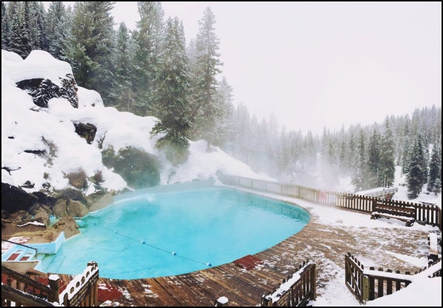
Two hot springs emerge from fractures in lower Paleozoic rocks. The Granite Falls Hot Springs are three streams that rise from the Cambrian Flathead Formation flowing at a combine rate of 120 gallons per minute at 113 degrees F (45 degrees C). The Granite Hot Springs flows at 300 gallons per minute at 106 degrees F (41degrees C) from the Death Canyon Limestone. The Civilian Conservation Corps constructed a 50 foot diameter pool for visitors to the Bridger-Teton National Forest in 1933.
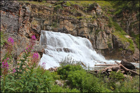
We highly recommend a trip to the Granite Hot Springs for a soak in the warm pool. The drive is scenic, there is a preety waterfall about 1/3rd mile before the pool and the hot springs is a well maintained facility in a remote location. There is a fee to use the pool and it has a summer season and a winter season (see Forest Service webpage for operation dates and times). In the winter, you can only access it via snowmobile, cross country skis, dog sled or fat tire bike. The pool is drained every night when operating, so there is no chlorination of the water. An undeveloped hot spring adjacent to Granite Falls is located on the east side of Granite Creek that we have not visited. It requires crossing the cold and swift water of Granite Creek or another access option is to walk downstream from Granite Hot Springs on a path along the east shore of the creek. Directions from Jackson: head south out of Jackson on US 191 South/ US 26 West/ US 89 South, drive 13 miles to the roundabout in Hoback Junction and take second exit onto US 189 South/ US 191 South, drive 11 miles and turn left (north) on Granite Road/Granite Creek Road/ Forest Service Road 30500. Drive on this gravel road that follows Granite Creek about 10 miles to the parking area for Granite Hot Springs. Walk about 750 feet from parking area to pool. Total 34 miles, total driving time is just under an hour.
We highly recommend a trip to the Granite Hot Springs for a soak in the warm pool. The drive is scenic, there is a preety waterfall about 1/3rd mile before the pool and the hot springs is a well maintained facility in a remote location. There is a fee to use the pool and it has a summer season and a winter season (see Forest Service webpage for operation dates and times). In the winter, you can only access it via snowmobile, cross country skis, dog sled or fat tire bike. The pool is drained every night when operating, so there is no chlorination of the water. An undeveloped hot spring adjacent to Granite Falls is located on the east side of Granite Creek that we have not visited. It requires crossing the cold and swift water of Granite Creek or another access option is to walk downstream from Granite Hot Springs on a path along the east shore of the creek. Directions from Jackson: head south out of Jackson on US 191 South/ US 26 West/ US 89 South, drive 13 miles to the roundabout in Hoback Junction and take second exit onto US 189 South/ US 191 South, drive 11 miles and turn left (north) on Granite Road/Granite Creek Road/ Forest Service Road 30500. Drive on this gravel road that follows Granite Creek about 10 miles to the parking area for Granite Hot Springs. Walk about 750 feet from parking area to pool. Total 34 miles, total driving time is just under an hour.
Hot springs near the Cache Creek thrust fault. Left: Granite Falls & Granite Falls Hot Springs, Right: Granite Hot Springs pool.
Images: Left: Waves in the Desert Blog, 2014, http://www.azdon.net/blog/discovering-granite-falls-.html; Right: https://jhadventure.com/snowmobiles/.
Images: Left: Waves in the Desert Blog, 2014, http://www.azdon.net/blog/discovering-granite-falls-.html; Right: https://jhadventure.com/snowmobiles/.
Landslides in the Gros Ventre Range
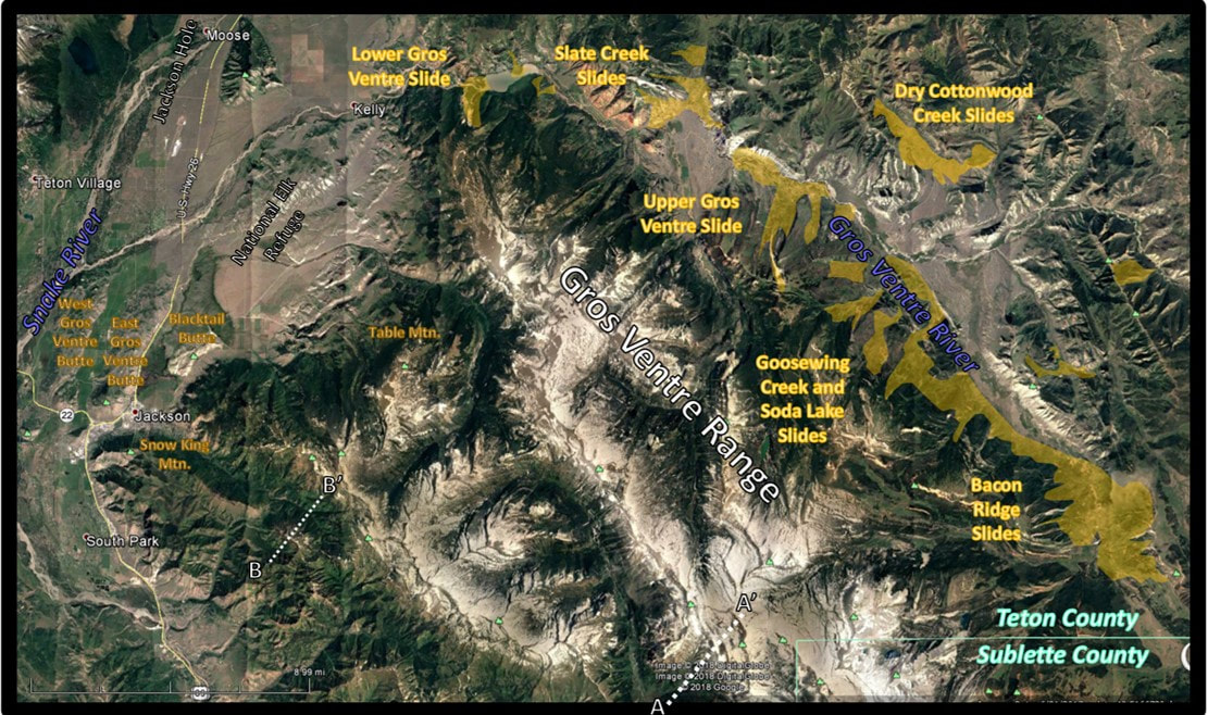
The valley of the Gros Ventre River is host to a number of landslides. Scars on the hillsides and hummocky, unsorted, angular deposits on the valley floor give evidence of this activity. The debris has occassionally dammed the river creating, lakes. The most recent slide occurred in 1925 about five miles east of Kelly, Wyoming. The Lower Gros Ventre slide released a 50 million cubic yard mass down the north face of Sheep Mountain that slammed 300-400 feet up the opposite side of the river. It formed a 325 feet high,half mile wide dam across the river. The slide originated in the Tensleep sandstone 2,000 feet above the river valley.
Landslides can occur when slopes become unstable. The main factors are grouped into four catagories: geological, morphological, physical and human (Wikipedia). Multiple elements can lead to a slide.
Geological causes:
Topography
Lower Gros Ventre slide involved several factors: 1) The river had eroded the toe of the Tensleep (increases slope angle), 2) beds were dipping into the valley at 20o, 3) abundant winter snow and spring rain had drained through the porous Tensleep Sandstone and saturated the surface of the underlying impermeable Amsden Formation, and 4) ground vibration from small earthquake activity.
Two years later the dam on Lower Slide Lake was overtopped and partially gave way which caused a wall of water to flood down the Gros Ventre River through the town of Kelly and reached far as Wilson 14 miles away.
Landslides can occur when slopes become unstable. The main factors are grouped into four catagories: geological, morphological, physical and human (Wikipedia). Multiple elements can lead to a slide.
Geological causes:
- Weathered materials
- Sheared materials
- Jointed or fissured materials
- Adversely orientated discontinuities
- Permeability contrasts
- Material contrasts
- Rainfall and snow fall
- Earthquakes
- Slope angle
- Uplift
- Rebound
- Fluvial erosion
- Wave erosion
- Glacial erosion
- Erosion of lateral margins
- Subterranean erosion
- Slope loading
- Vegetation change
- Erosion
Topography
- Slope Aspect and Gradient
- Discontinuity Factors: dip spacing, Asparity (area on a fault that is stuck), dip and length
- Physical Characteristics of the Rock (rock strength etc.)
- Seismic activity (earthquakes)
- Volcanic eruption
- Thawing
- Freeze-thaw
- Soil erosion
- Intense rainfall
- Rapid snow melt
- Prolonged precipitation
- Ground water changes (rapid drawdown)
- Soil pore water pressure
- Surface runoff
- Deforestation
- Excavation
- Loading
- Water management (groundwater draw-down and water leakage)
- Land use (e.g. construction of roads, houses etc.)
- Mining and Quarrying
- Vibration
Lower Gros Ventre slide involved several factors: 1) The river had eroded the toe of the Tensleep (increases slope angle), 2) beds were dipping into the valley at 20o, 3) abundant winter snow and spring rain had drained through the porous Tensleep Sandstone and saturated the surface of the underlying impermeable Amsden Formation, and 4) ground vibration from small earthquake activity.
Two years later the dam on Lower Slide Lake was overtopped and partially gave way which caused a wall of water to flood down the Gros Ventre River through the town of Kelly and reached far as Wilson 14 miles away.
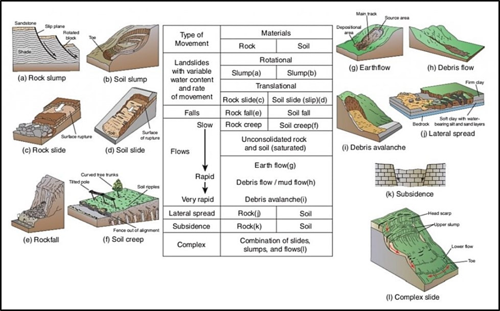
Types of mass movement. Classification of landslides, based on type of movement, materials, water content, and rate of movement (After U.S. Geological Survey 2004. Fact Sheet 2004-3072).
Engineering Geology, 2018, Types of Landslides, Fig.1; https://engineeringeology.com/2018/10/16/types-of-landslides.
Engineering Geology, 2018, Types of Landslides, Fig.1; https://engineeringeology.com/2018/10/16/types-of-landslides.
The Slate Creek Slides are located six miles upstream from Lower Slide Lake. The area is on the north side of the river and encompasses several incompetent (shale and claystone beds) Mesozoic units. The numerous slides in the area include strata from Frontier to Chugwater. Most units moved as earth flows, but mud flows occurred also when precipitation was higher (see mass movement diagram above). The slide movement was to the south and southeast due to high relief, steep valley walls, and rock composition.
The Upper Gros Ventre Slide is five miles further upstream of the Slate Creek Slides along the north side of the valley. The coalescing of two slides blocked the river creating Upper Slide Lake. The stratigraphic units involved the same Mesozoic units as at Slate Creek.
The Dry Cottonwood Creek Slides are four miles upstream from Upper Slide Lake. The slide consists of slump block of Latest Cretaceous-Early Paleocene Pinyon Conglomerate. Large blocks of the conglomerate broke away from an underlying saturated incompetent shale.
Goosewing and Soda Lake Slides are located three miles upstream of the Dry Cottonwood Creek Slides along the southwest wall of the valley at the base of Sportsman Ridge. The slides moved down stream valleys and spread over the flats. The slides originated in Mesozoic claystones and shales. Soda Lake is impounded by slide debris.
Bacon Ridge Slides are five miles further upstream of the Soda Lake Slides located between Bacon Ridge and the southern end of Sportsman Ridge. Both sides of the valley produced slides in the saturated, incompetent Mesozoic shales and claystones. The area is still prone to slides, particularly in wet years.
Gros Ventre Valley Landslides in yellow. Location of structural cross sections AA’ and BB’ are shown by white dotted lines.
Image: Google Earth, Data: Keefer, W.R. and Love, J.D., 1956, Landslides Along the Gros Ventre River, Teton County, Wyoming: Wyoming Geological Association 11thAnnual Field Conference Guidebook, Fig. 1, p. 25.
Image: Google Earth, Data: Keefer, W.R. and Love, J.D., 1956, Landslides Along the Gros Ventre River, Teton County, Wyoming: Wyoming Geological Association 11thAnnual Field Conference Guidebook, Fig. 1, p. 25.
Gros Ventre Valley landslides.
Images: Google Earth, Data: Keefer, W.R. and Love, J.D., 1956, Landslides Along the Gros Ventre River, Teton County, Wyoming: Wyoming Geological Association 11th Annual Field Conference Guidebook, Fig. 1, p. 25.
Images: Google Earth, Data: Keefer, W.R. and Love, J.D., 1956, Landslides Along the Gros Ventre River, Teton County, Wyoming: Wyoming Geological Association 11th Annual Field Conference Guidebook, Fig. 1, p. 25.
The Gros Ventre Range is home to a large migratory population of elk and antelope. At least three pack of wolves roam the area: 1) Slate Creek, 2) Towgotee, and 3) Lava Mountain. This is the greatest number of wolves outside of Yellowstone National Park. Moose and bear also live here.
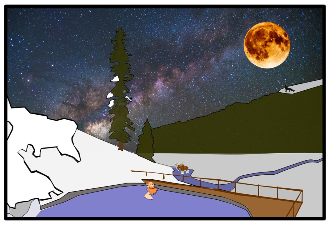
Sitting in a hot spring, relaxing in the spectacular wilderness scenery, with wildlife wandering past and the howl of wolves echoing across the mountain landscape is what makes this one of Wyoming’s top treasures.
Sitting in a hot spring, relaxing in the spectacular wilderness scenery, with wildlife wandering past and the howl of wolves echoing across the mountain landscape is what makes this one of Wyoming’s top treasures.
Cartoon by Ken Steele

The material on this page is copyrighted
