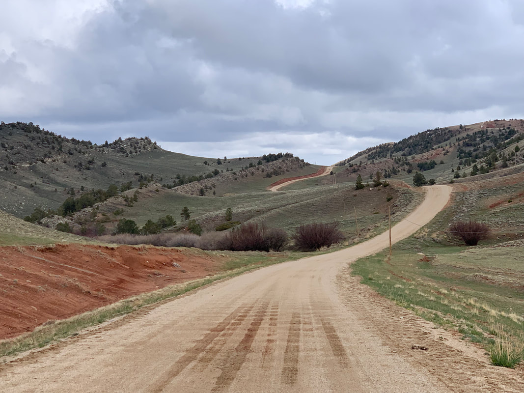
Southeast view of Triassic outcrops along Natrona County Road 201 near Ervay
Image: Mark Fisher
Image: Mark Fisher
Wow Factor (2 out of 5 stars):

Geologist Factor (3 out of 5 stars):

Attraction
A large breached geologic fold called an anticline in the Wind River Basin
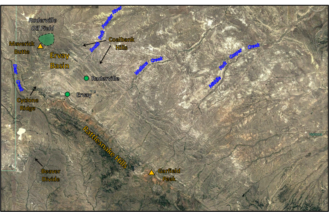
North aerial view of Ervay Basin & Raderville Oil Field, Central Wyoming.
Image: Google Earth
Image: Google Earth
Ervay Basin History
Ervay Basin at the north end of the Rattlesnake Hills Anticline is named after a discontinued Post Office in western Natrona County. The town was founded by Jacob E. Ervay in 1882, who served as the first Postmaster and land recorder for the Rattlesnake District. He was also an early wildcat driller in the area at about the same time as the Murphy Brothers drilled the first oil discovery at Dallas Field in 1884.
The former townsite of Ervay (n, ne, nw Section 32, Township 34 North, Range 88 West) is located along the Casper to Lander stage line (Urbanek, M., 1988, Wyoming Place Names, p. 63). The route carried passengers, freight, and mail from the railroad terminus in Casper (1888) to Lander and Thermopolis. Little evidence remains of the stage road or stations. Stone Ranch station (Section 34, Township 35 North, Range 82 west) is one of the few structures remaining along the route. The station was listed on the National Register of Historic Places in 1982 (https://wyoshpo.wyo.gov/index.php/programs/national-register/wyoming-listings/view-full-list/711-stone-ranch-stage-station). The stage route was abandoned with the construction of the railroad to Lander in 1905-1906.
The former townsite of Ervay (n, ne, nw Section 32, Township 34 North, Range 88 West) is located along the Casper to Lander stage line (Urbanek, M., 1988, Wyoming Place Names, p. 63). The route carried passengers, freight, and mail from the railroad terminus in Casper (1888) to Lander and Thermopolis. Little evidence remains of the stage road or stations. Stone Ranch station (Section 34, Township 35 North, Range 82 west) is one of the few structures remaining along the route. The station was listed on the National Register of Historic Places in 1982 (https://wyoshpo.wyo.gov/index.php/programs/national-register/wyoming-listings/view-full-list/711-stone-ranch-stage-station). The stage route was abandoned with the construction of the railroad to Lander in 1905-1906.

1899 advertisement for stage service from Casper railroad terminus to Lander, Thermopolis, and points in between. The Casper to Lander stage along the road. The stage from Casper to Lander cost passengers fourteen dollars, while the express rate was five cents. The 2020 equivalent value is about $395 and $1.40 respectively.
Image: Left http://www.wyomingtalesandtrails.com/casper.html; and Right: http://www.wyomingtalesandtrails.com/lander2.html.
Image: Left http://www.wyomingtalesandtrails.com/casper.html; and Right: http://www.wyomingtalesandtrails.com/lander2.html.
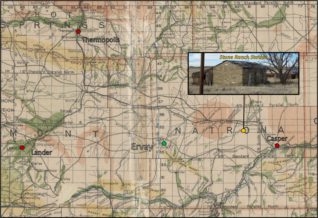
Map of stage lines extending from Casper railroad terminus. The two main roads have black infill while blank roads are roads to smaller serviced communities. Dots: current town: red; abandoned town: green; Stone Ranch Station: gold.
Image: Beeler, H.C., 1913, Clason's industrial map of Wyoming; https://uwdigital.uwyo.edu/islandora/object/wyu%3A118217.
Image: Beeler, H.C., 1913, Clason's industrial map of Wyoming; https://uwdigital.uwyo.edu/islandora/object/wyu%3A118217.
Ervay Basin Geology
The landscape is a classic breached anticline on the Rattlesnake Hills fold. An anticline eroded into the center of the fold are referred to as a breached or scalped structure. The anticline erodes down the dip of rocks leaving the older units toward the center. This is like the layers of an onion have the oldest part in the core. A topographic basin is formed when nonresistant shales are surrounded by escarpments of more resistant sandstone or limestone. The Eocene Wind River Formation forms the western escarpment and the ridge and swale topography of the Cretaceous Mesaverde, Lance and Tertiary Fort Union Formations border the eastern side. These eroded basins are common in the Rocky Mountains and are often called “sheepherder anticlines” due to surrounding rock “fence.” Serval large breached anticline examples are Oregon Basin, Little Buffalo Basin, and Elk Basin oil fields in the Bighorn Basin. The Rattlesnake Hills Anticline is eroded through the entire stratigraphic section and into the Precambrian basement. Raderville oil field is a combination trap located on the faulted northeast nose of the anticline. Stray sands within the upper Cody Shale have produced over eight hundred and ninety thousand barrels of 22.5 API gravity oil.
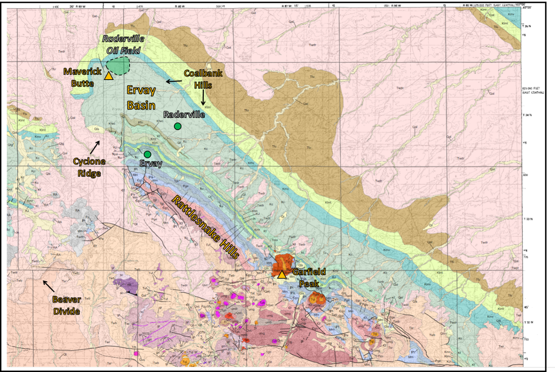
Geologic map of the Ervay Basin.
Image: After Sutherland, Wayne, and Hausel, W.D., 2003, Geologic map of the Rattlesnake Hills 30’ x 60’ quadrangle, Fremont and Natrona counties, Wyoming: Wyoming State Geological Survey Map Series 61, scale 1:100,000; https://www.wsgs.wyo.gov/products/wsgs-2003-ms-61.pdf.
Image: After Sutherland, Wayne, and Hausel, W.D., 2003, Geologic map of the Rattlesnake Hills 30’ x 60’ quadrangle, Fremont and Natrona counties, Wyoming: Wyoming State Geological Survey Map Series 61, scale 1:100,000; https://www.wsgs.wyo.gov/products/wsgs-2003-ms-61.pdf.

Diagram of a breached anticline. Dashed line is axis of anticline (fold), arrows are direction of bed dip, Kcv = Cretaceous Cloverly, Kt = Cretaceous Thermopolis Shale, Kmr = Cretaceous Mowry Shale, Kf = Cretaceous Frontier Sandstones, Kc = Cretaceous Cody Shale, Kmv = Cretaceous Mesaverde Sandstones, Twdr = Tertiary Wind River Formation.
Image: After Baars, D.L., Watney, W.L. , Steeples, D.W. and Brostuen, E.A., 2001 (Online version), Petroleum: a primer for Kansas, Fig. 5 ; http://www.kgs.ku.edu/Publications/Oil/primer05.html.
Image: After Baars, D.L., Watney, W.L. , Steeples, D.W. and Brostuen, E.A., 2001 (Online version), Petroleum: a primer for Kansas, Fig. 5 ; http://www.kgs.ku.edu/Publications/Oil/primer05.html.
Cretaceous Cody Shale
The Cody Shale was deposited over eighty million years ago (Ma) consisting of two parts: an upper sandy member (Santonian, 86-82 Ma), and a lower shaly member (Coniacian, 90-86 Ma). Both are marine deposits within the Western Interior Seaway that remained continuous from the Arctic to the Gulf during numerous transgression (sea level rise) and regression (sea level fall) cycles. The increase in coarser clastic sediment during Santonian time reflect the ongoing uplift of the Sevier orogen source area to the west.
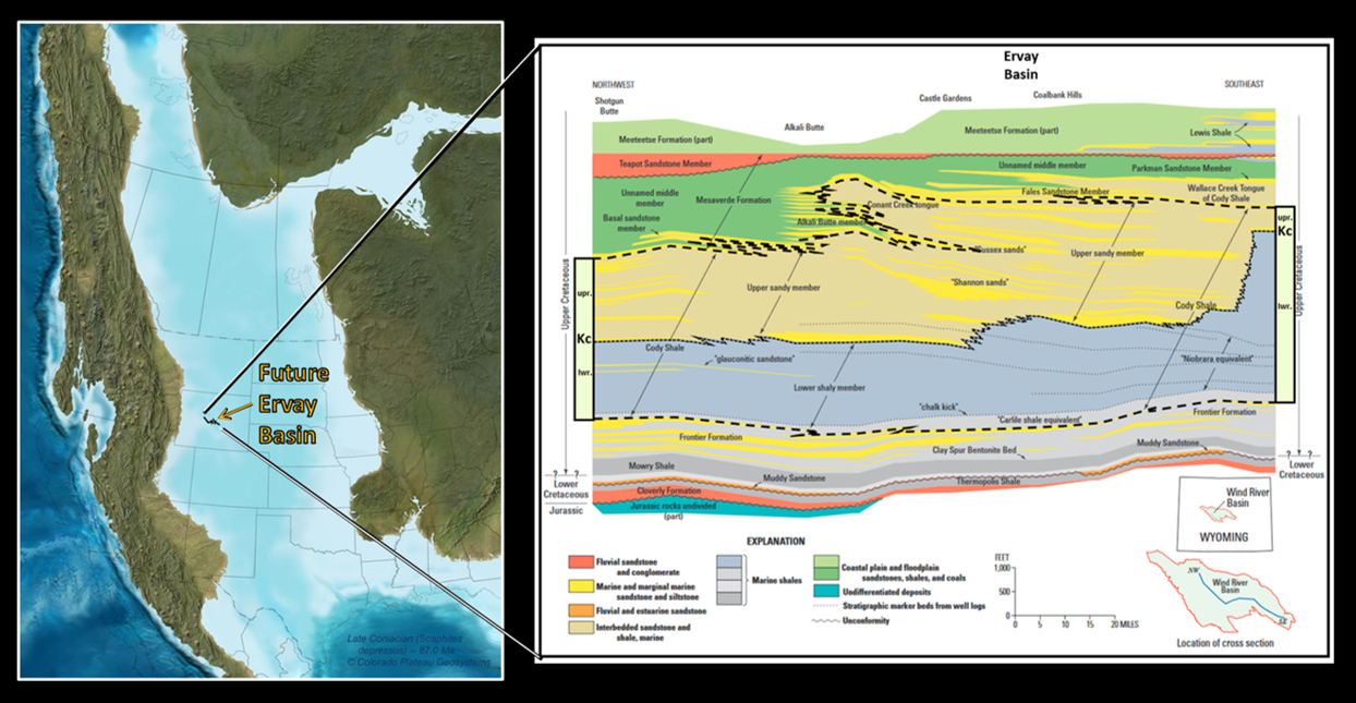
Left: Paleogeography of Western Interior Seaway during Late Coniacian (87 million years ago) Cody Shale deposition. Right: Regional northwest-southeast facies cross section of the Mesaverde Formation, upper and lower members of the Cody Shale, Frontier Formation and Mowry Shale.
Image: Left: Blakey, R.C. 2014, Paleogeography and Paleotectonics of the Western Interior Seaway, Jurassic-Cretaceous of North America: American Association of Petroleum Geologists Search and Discovery Article #30392; http://www.searchanddiscovery.com/documents/2014/30392blakey/ndx_blakey.pdf; Right: Image: Finn, T.M., and Pawlewicz, M.J., 2013, Maps showing thermal maturity of Upper Cretaceous marine shales in the Wind River Basin, Wyoming: U.S. Geological Survey Scientific Investigations Map 3266, Fig. 4, p. 5; https://pubs.usgs.gov/sim/3266/pdf/sim3266.pdf.
Image: Left: Blakey, R.C. 2014, Paleogeography and Paleotectonics of the Western Interior Seaway, Jurassic-Cretaceous of North America: American Association of Petroleum Geologists Search and Discovery Article #30392; http://www.searchanddiscovery.com/documents/2014/30392blakey/ndx_blakey.pdf; Right: Image: Finn, T.M., and Pawlewicz, M.J., 2013, Maps showing thermal maturity of Upper Cretaceous marine shales in the Wind River Basin, Wyoming: U.S. Geological Survey Scientific Investigations Map 3266, Fig. 4, p. 5; https://pubs.usgs.gov/sim/3266/pdf/sim3266.pdf.

Ervay Basin type log showing major resources of Cody, Frontier, and Sundance Formations.
Image: After Toner, R.N., Lynds, R.M., Freye, A.M., and Sutherland, W.M., 2016, Preliminary geologic map of the Ervay Basin quadrangle, Natrona County, Wyoming: Wyoming State Geological Survey Open File Report 2016-3, scale 1:24,000; http://sales.wsgs.wyo.gov/preliminary-geologic-map-of-the-ervay-basin-quadrangle-natrona-county-wyoming-2016.
Image: After Toner, R.N., Lynds, R.M., Freye, A.M., and Sutherland, W.M., 2016, Preliminary geologic map of the Ervay Basin quadrangle, Natrona County, Wyoming: Wyoming State Geological Survey Open File Report 2016-3, scale 1:24,000; http://sales.wsgs.wyo.gov/preliminary-geologic-map-of-the-ervay-basin-quadrangle-natrona-county-wyoming-2016.
Raderville Oil Field

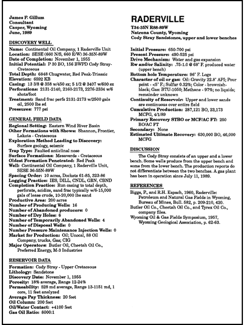
Structural-stratigraphic oil accumulation at Raderville Field in the Cody, Ervay Basin. Cumulative production is 899,000 BO and 474 MMCFG.
Image: After Gillum, J.P. 1989, Wyoming Oil and Gas Fields Symposium; Bighorn and Wind River Basins, 1989, Fig. on p. 394-395.
Image: After Gillum, J.P. 1989, Wyoming Oil and Gas Fields Symposium; Bighorn and Wind River Basins, 1989, Fig. on p. 394-395.
Cretaceous Frontier Formation
Bentonite is currently mined from the Frontier Formation on the Northeast limb of the Rattlesnake Hills anticline. Bentonite is a swelling clay made from altered volcanic ash. Active volcanoes during the Cretaceous sent a large volume of ash (glass) that rained down into the Western Interior Seaway. Wyoming holds 70% of the world’s known deposits of bentonite.
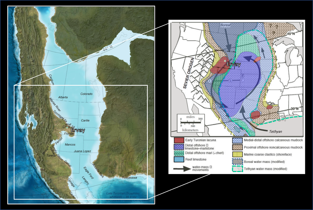
Paleogeographic map for North America during Early Turonian time (about 90 million years ago) illustrates Sevier orogen, extent of continental flooding in Western Interior at peak highstand, major lithofacies, Tethyan and Boreal water masses (modified by mixing within the basin), and relative water mass movements.
Image: Left: Blakey, R.C. 2014, Paleogeography and Paleotectonics of the Western Interior Seaway, Jurassic-Cretaceous of North America: American Association of Petroleum Geologists Search and Discovery Article #30392; http://www.searchanddiscovery.com/documents/2014/30392blakey/ndx_blakey.pdf; Right: Arthur, M.A. and Sageman, B.B., 2014, Sea-Level Control on Source-Rock Development: Perspectives from the Holocene Black Sea, the Mid-Cretaceous Western Interior Basin of North America, and the Late Devonian Appalachian Basin: SEPM Special Publication 82, Fig. 7, p. 42; https://www.google.com/url?sa=t&rct=j&q=&esrc=s&source=web&cd=&cad=rja&uact=8&ved=2ahUKEwiBrdbCyf_pAhUcRjABHUgaB2wQFjACegQIAxAB&url=http%3A%2F%2Fciteseerx.ist.psu.edu%2Fviewdoc%2Fdownload%3Fdoi%3D10.1.1.914.7858%26rep%3Drep1%26type%3Dpdf&usg=AOvVaw3gPeK55hqohtnRWDr_RDgh.
Image: Left: Blakey, R.C. 2014, Paleogeography and Paleotectonics of the Western Interior Seaway, Jurassic-Cretaceous of North America: American Association of Petroleum Geologists Search and Discovery Article #30392; http://www.searchanddiscovery.com/documents/2014/30392blakey/ndx_blakey.pdf; Right: Arthur, M.A. and Sageman, B.B., 2014, Sea-Level Control on Source-Rock Development: Perspectives from the Holocene Black Sea, the Mid-Cretaceous Western Interior Basin of North America, and the Late Devonian Appalachian Basin: SEPM Special Publication 82, Fig. 7, p. 42; https://www.google.com/url?sa=t&rct=j&q=&esrc=s&source=web&cd=&cad=rja&uact=8&ved=2ahUKEwiBrdbCyf_pAhUcRjABHUgaB2wQFjACegQIAxAB&url=http%3A%2F%2Fciteseerx.ist.psu.edu%2Fviewdoc%2Fdownload%3Fdoi%3D10.1.1.914.7858%26rep%3Drep1%26type%3Dpdf&usg=AOvVaw3gPeK55hqohtnRWDr_RDgh.

Left: Wyoming bentonite formed by the decomposition of volcanic ash deposited millions of years ago in an ancient inland seaway. Right: Northwest aerial view of bentonite mine in Frontier Formation, Ervay Basin.
Image: Left: Sunderland, W., 2014, Wyoming Bentonite, Summary Report: Wyoming State Geologic Survey; https://www.wsgs.wyo.gov/products/wsgs-2014-bentonite-summary.pdf;
Right: Google Earth
Image: Left: Sunderland, W., 2014, Wyoming Bentonite, Summary Report: Wyoming State Geologic Survey; https://www.wsgs.wyo.gov/products/wsgs-2014-bentonite-summary.pdf;
Right: Google Earth

West to east subsurface cross section showing Frontier Sandstone, Ervay Basin. Approximate location of discontinued Ervay Post Office shown.
Image: After Burk, C.A., 1956, Subsurface Correlation in the Wind River Basin Central Wyoming: Wyoming Geological Association, Wyoming Stratigraphy, Subsurface Stratigraphy of the Pre-Niobrara Formations in Wyoming.
Image: After Burk, C.A., 1956, Subsurface Correlation in the Wind River Basin Central Wyoming: Wyoming Geological Association, Wyoming Stratigraphy, Subsurface Stratigraphy of the Pre-Niobrara Formations in Wyoming.
Jurassic Sundance Formation
Dr. Wilber Knight, a Wyoming professor and state geologist, discovered the remains of a large Pliosaur in 1895. Pliosaurs were carnivorous marine reptiles with large heads and jaws. Dr Knight described the site in correspondence to J. E. Ervay: a location “… 10 miles from the Ervay Post Office.” The site lies within the upper Redwater Shale Member, Sundance Formation in Dutton Basin. Dutton Basin is another breached anticline to the west of Ervay Basin. The Redwater Shale member lithology at the excavation consists of glauconitic fine sandstone deposited in a high energy environment.

Approximate excavation site of Megalneusaurus rex, Dutton Basin.
Image: Left: Google Earth; Right: https://www.paleonature.org/lets-go-scientific/91-the-largest-pliosaurid-from-north-america.
Image: Left: Google Earth; Right: https://www.paleonature.org/lets-go-scientific/91-the-largest-pliosaurid-from-north-america.

Reconstruction of Megalneusaurus rex by Dmitry Bogdanov.
Image: https://www.paleonature.org/lets-go-scientific/91-the-largest-pliosaurid-from-north-america.
Image: https://www.paleonature.org/lets-go-scientific/91-the-largest-pliosaurid-from-north-america.
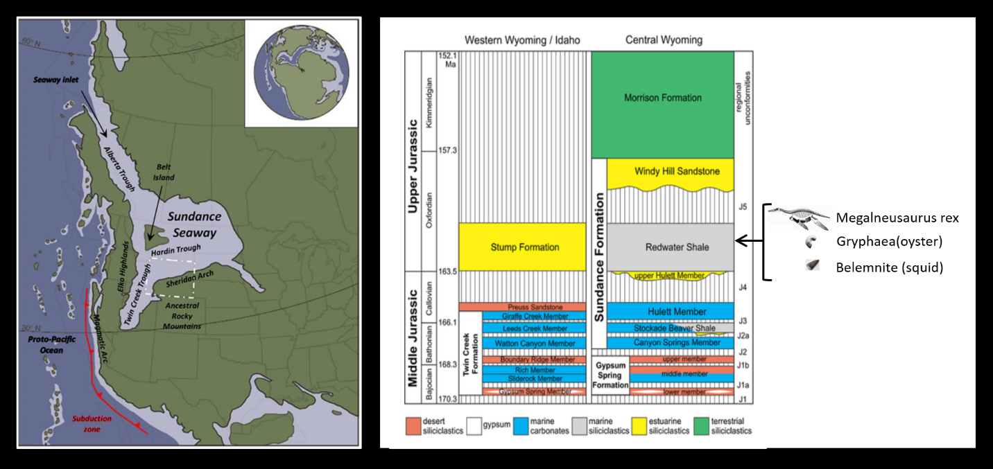
Middle Jurassic paleogeography and stratigraphic column. Wyoming shown by white dashed line on map.
Image: After https://www.geowyo.com/red-gulch-dinosaur-tracksite--sundance-seaway.html;
http://projectmarest.weebly.com/resources.html.
Image: After https://www.geowyo.com/red-gulch-dinosaur-tracksite--sundance-seaway.html;
http://projectmarest.weebly.com/resources.html.

Paleogeographic reconstructions of continents and seas throughout the Late Jurassic Period showing approximate locations of the type occurrence of Megalneusaurus in the Sundance Formation of Wyoming (gold star) and the reported occurrence in the Naknek Formation of Alaska (red star).
Image: After http://www.sepmstrata.org/page.aspx?pageid=743; Data After: Weems, R.E. and Blodgett, R.B., 1996, The pliosaurid Megelneusaurus: a newly recognized occurrence in the Upper Jurassic Naknek Formation of the Alaska Peninsula: in U.S. Geological Survey Bulletin 2152, p169-176: https://ecos.fws.gov/ServCat/DownloadFile/129372?Reference=85097
Image: After http://www.sepmstrata.org/page.aspx?pageid=743; Data After: Weems, R.E. and Blodgett, R.B., 1996, The pliosaurid Megelneusaurus: a newly recognized occurrence in the Upper Jurassic Naknek Formation of the Alaska Peninsula: in U.S. Geological Survey Bulletin 2152, p169-176: https://ecos.fws.gov/ServCat/DownloadFile/129372?Reference=85097
Permian Ervay Member, Phosphoria Formation
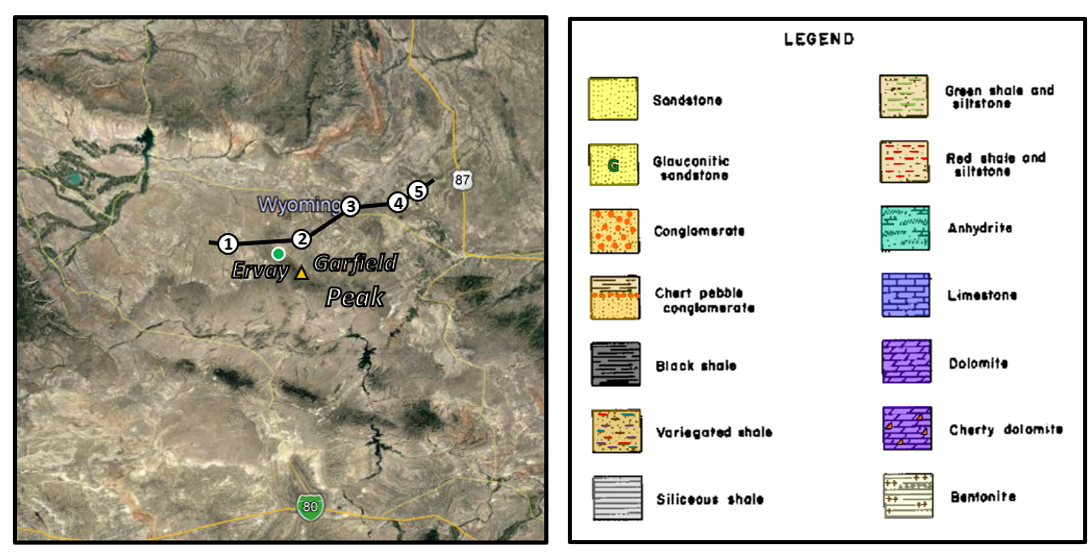
Dr. Horace Thomas, a future Wyoming State Geologist, studied the complex stratigraphic correlation and relationship of the Triassic and Permian rocks in the southcentral Wind River Basin. He named the upper carbonate tongue of the Permian the Ervay after the nearby post office. The type area is at an outcrop on the flank of Garfield Peak, Rattlesnake Hills.

Permian paleogeographic and stratigraphic column. Black dots are cross section well locations. Green dot is abandoned Ervay townsite.
Image: Left: After Blakey, R.C., 2011, Late Permian (260 Ma): Paleogeography of Western North America DVD, Colorado Plateau Geosystems, Arizona USA; Right: After Matheson, E.J. and Frank, T.D., 2019, An epeiric glass ramp: Permian low-latitude neritic siliceous sponge colonization and its novel preservation (Phosphoria Rock Complex): Sedimentary Geology, Vol. 399, Fig. 2.
Image: Left: After Blakey, R.C., 2011, Late Permian (260 Ma): Paleogeography of Western North America DVD, Colorado Plateau Geosystems, Arizona USA; Right: After Matheson, E.J. and Frank, T.D., 2019, An epeiric glass ramp: Permian low-latitude neritic siliceous sponge colonization and its novel preservation (Phosphoria Rock Complex): Sedimentary Geology, Vol. 399, Fig. 2.

West to east subsurface cross section showing pinch-out of Ervay Member, Park City Formation. Wells are the same in the Frontier Formation cross section. Approximate location of discontinued Ervay Post Office shown.
Image: After Burk, C.A., 1956, Subsurface Correlation in the Wind River Basin Central Wyoming: Wyoming Geological Association, Wyoming Stratigraphy, Subsurface Stratigraphy of the Pre-Niobrara Formations in Wyoming.
https://en.wikipedia.org/wiki/Megalneusaurus
Image: After Burk, C.A., 1956, Subsurface Correlation in the Wind River Basin Central Wyoming: Wyoming Geological Association, Wyoming Stratigraphy, Subsurface Stratigraphy of the Pre-Niobrara Formations in Wyoming.
https://en.wikipedia.org/wiki/Megalneusaurus
Things-To-Do
- Castle Gardens Petroglyphs
- Beaver Divide
- Agate Flats
- Hells Half Acre

Google Earth

The material on this page is copyrighted