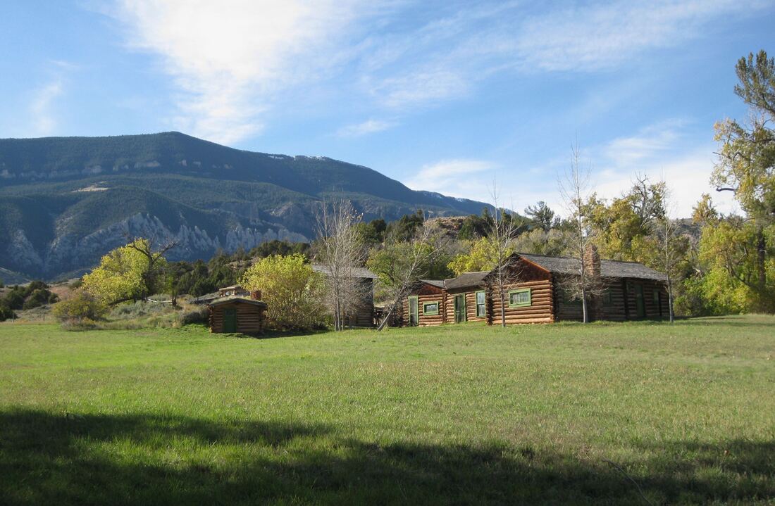
Images by Mark Fisher
Wow Factor (5 out of 5 stars):
Geologist Factor (4 out of 5 stars):
Attraction
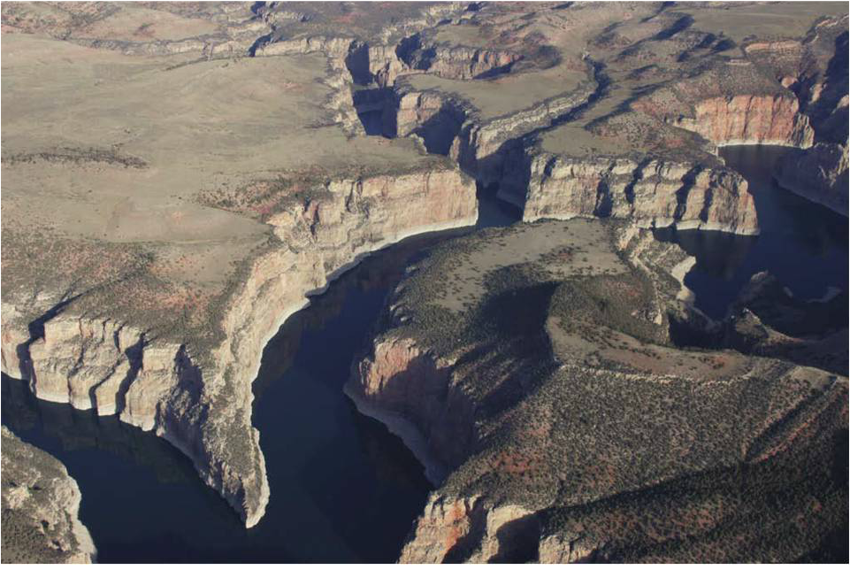
Spectacular canyon with cliffs of Madison carbonates dropping 900 feet to Bighorn Lake, colorful arid landscapes, views of Pryor Mountains to west and Bighorn Mountains to east, historic ranches, Native American tipi rings and cairns, wild horses, bighorn sheep, raptors, hikes, lightly visited and relatively isolated. If you have a motor boat, you need to experience the canyon from the water. It may be the prettiest place you ever boat or water ski. The water is tolerably warm compared to most lakes in Wyoming.
Geology of Bighorn Canyon
For over 10,000 years Native Americans (mainly Crow & Shoshone) traveled the Bad Pass Trail from the Bighorn Basin of Wyoming, through Bighorn Canyon to the bison hunting grounds of south-central Montana. The trail was located on the west side of the canyon above the Bighorn River. Washington Irving recorded Captain Bonneville’s account of his 1833 trip across the Bighorns:
“On reaching the … Bighorn Mountains, where the river forced its impetuous way through a precipitous defile, with cascades and rapids, the travelers were obliged to leave its banks, and traverse the mountains by a rugged and frightful route, emphatically called the “Bad Pass”
“On reaching the … Bighorn Mountains, where the river forced its impetuous way through a precipitous defile, with cascades and rapids, the travelers were obliged to leave its banks, and traverse the mountains by a rugged and frightful route, emphatically called the “Bad Pass”
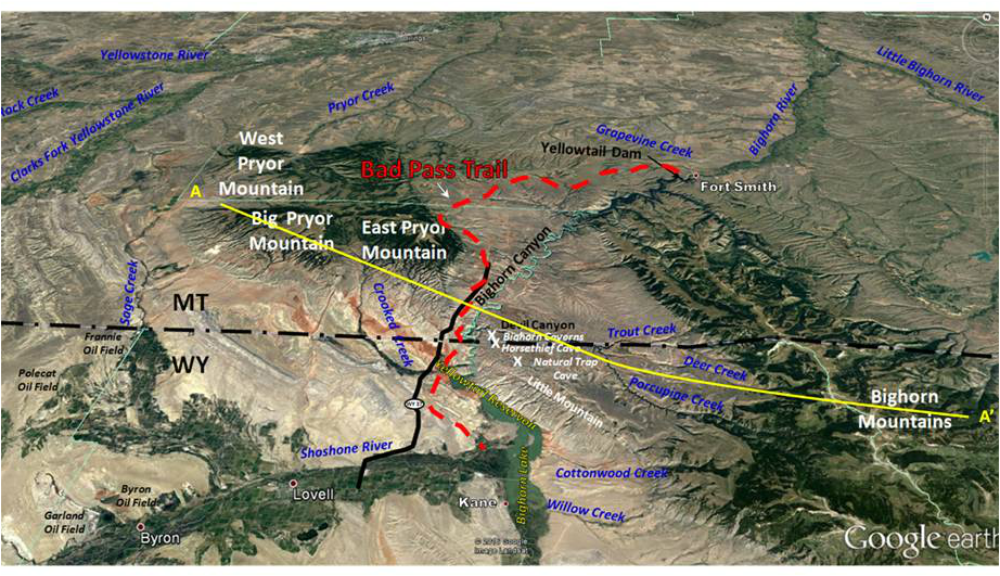
Bad Pass Trail (red dashed line) extends from confluence of the Bighorn and Shoshone Rivers, WY to the mouth of Grapevine Creek, MT (Fort Smith, MT to Lovell, WY). Location of paved portion of WY 37 (black solid line), caves on Little Mountain (white X) and the ghost town of Kane are shown on image.
Google Earth Image
Google Earth Image
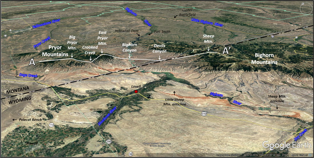
Bighorn Canyon structural cross section AA’.
After National Park Service 1974 Bighorn Canyon Brochure http://npshistory.com/brochures/bica/1974.pdf
After National Park Service 1974 Bighorn Canyon Brochure http://npshistory.com/brochures/bica/1974.pdf
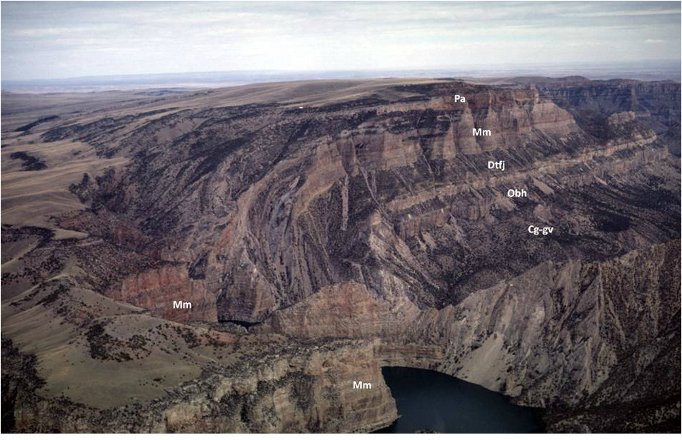
Northeast aerial view of Bighorn Canyon area.
Image: After Computer Terrane Mapping, Inc. http://www.ctmap.com/ctm_image/bighorncanyon.png
Image: After Computer Terrane Mapping, Inc. http://www.ctmap.com/ctm_image/bighorncanyon.png
The path is marked by hundreds of rock cairns and numerous tepee rings. Fur trappers and mountain men began using this route instead of the dangerous water course through the canyon about 1824. The first reported water traverse of the canyon was made by Jim Bridger in 1825. He made the trip solo on a driftwood raft after the rest of the trapping party chose to take the land route over Bad Pass Trail. Wyoming Highway 37 parallels a portion of this ancient highway through the Bighorn Mountains.
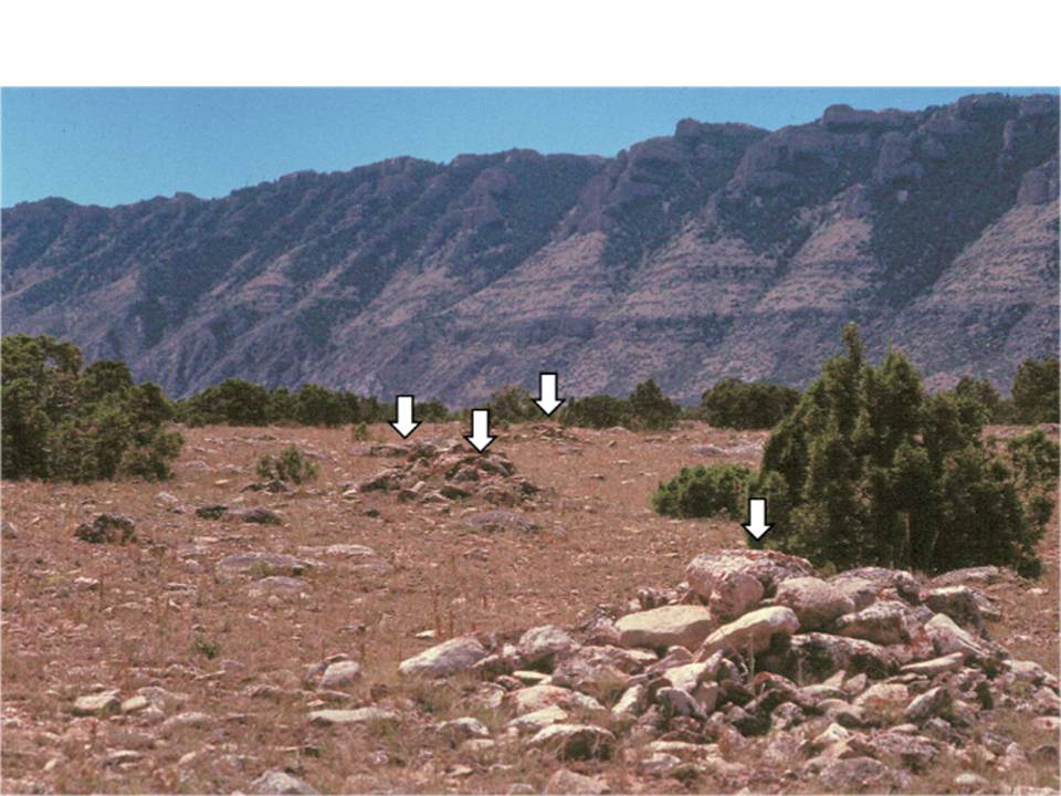
Left: Rock Cairns (arrows) on Bad Pass Trail. The rock piles were built by Native Americans to mark trails and as a sign of good luck for travelers.
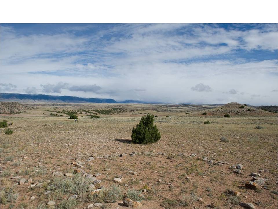
Right: teepee ring marking a favorable Native American campsite near a food and water source.
Images: Left: https://commons.wikimedia.org/w/index.php?curid=8927187
Right: https://upload.wikimedia.org/wikipedia/commons/4/4e/Tipi_rings_in_the_Pryor_Mountains.jpg
Right: teepee ring marking a favorable Native American campsite near a food and water source.
Images: Left: https://commons.wikimedia.org/w/index.php?curid=8927187
Right: https://upload.wikimedia.org/wikipedia/commons/4/4e/Tipi_rings_in_the_Pryor_Mountains.jpg
Bighorn Canyon is the product of uplift and stream erosion over the last five million years. The superposed Bighorn River became entrenched in the resistant Paleozoic carbonate rocks.
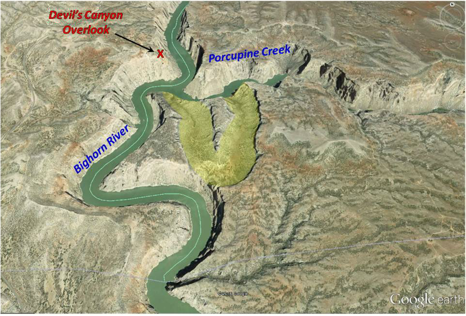
Entrenched meanders are notable geologic and scenic features at Bighorn Canyon National Recreation Area. The entrenched meanders of the Bighorn River, which cut into bedrock and through uplifted structural features, create the distinctively winding path of Bighorn Canyon.
Image: NPS/NRSS/GRD/NRR, 2011, Bighorn Canyon National Recreation Area: Geologic Resources Inventory Report, Figure 9, p. 19. http://npshistory.com/publications/bica/nrr-2011-447.pdf
Image: NPS/NRSS/GRD/NRR, 2011, Bighorn Canyon National Recreation Area: Geologic Resources Inventory Report, Figure 9, p. 19. http://npshistory.com/publications/bica/nrr-2011-447.pdf
Aerial view of “Natural Corrals” abandoned meander (yellow highlight) at confluence of the Bighorn River and Porcupine Creek. The feature records the location of a former stream.
Google Earth Image
Google Earth Image
The cliffs rise over a thousand feet above the river. The canyon meanders for 55 miles across the Wyoming-Montana border making it the third longest canyon in the United States. Bighorn Lake (Yellowtail Reservoir) formed in 1967 with the completion of the Yellowtail Dam and extends into Wyoming for a total length of 71 miles. The Wyoming community of Kane, located about two mile south of the junction of the Shoshone and Bighorn Rivers, was abandoned due to the anticipated drowning from the new lake.
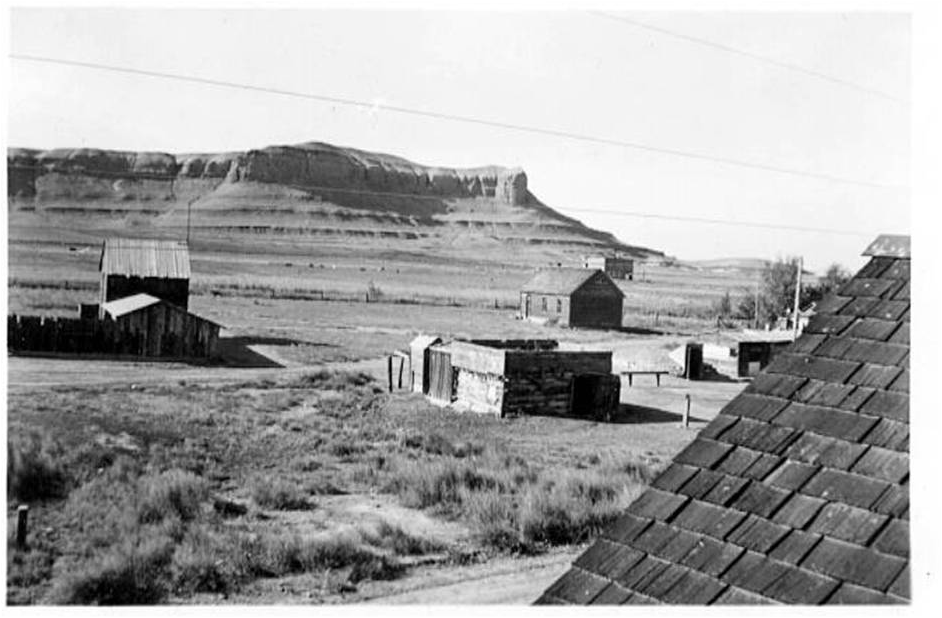
Kane, Wyoming before Bighorn Lake. View west from the Kane depot against the backdrop of the Kane Hills. Here the Frontier Sandstone caps a steep slope of Mowry and Thermopolis Shale. The town sits on a flat floodplain of Quaternary alluvium from the Bighorn River.
Image: Lovell-Kane Museum
Image: Lovell-Kane Museum
After NPS/NRSS/GRD/NRR, 2011, Bighorn Canyon National Recreation Area: Geologic Resources Inventory Report, Fig. 2, p. 3.; http://npshistory.com/publications/bica/nrr-2011-447.pdf
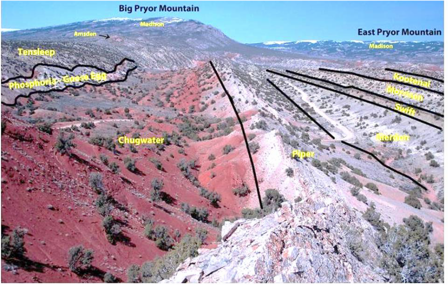
The less resistant Mesozoic clastic rocks are eroded away from the canyon but are present in the adjacent hills and on the flanks of the Pryor and Bighorn mountains. The most recognizable Mesozoic unit is the red Chugwater Formation.
North view of prominent Chugwater beds in Vermillion Valley about 8.5 miles west of the canyon.
Image: www.pryormountains.org/wp-content/gallery/vermillion-geology/DSC_0247-LBL-nx-s.jpg
Image: www.pryormountains.org/wp-content/gallery/vermillion-geology/DSC_0247-LBL-nx-s.jpg
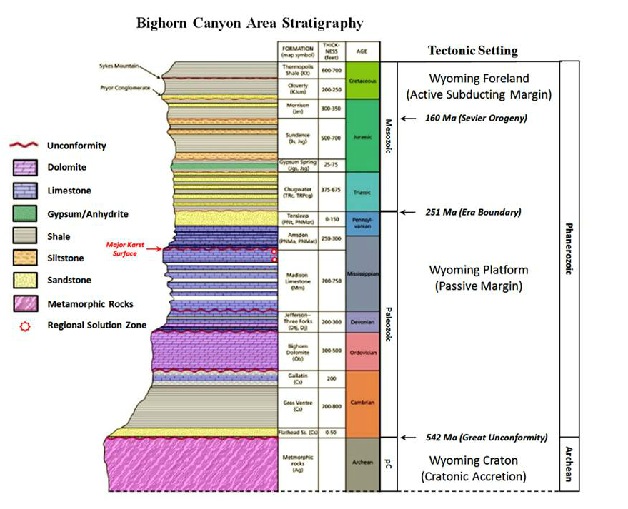
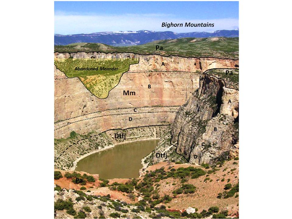
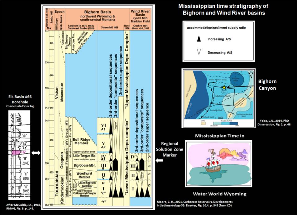
The canyon walls expose 38 million years of resistant Paleozoic carbonate rock of the Mississippian Madison Formation (359-347 Ma) and the Devonian Three Forks (374-359 Ma) and Jefferson Formations (385-374 Ma). The irregular top of the Madison is an erosion surface that was exposed about 10 million years before the Pennsylvanian Amsden Formation (337-315 Ma) was deposited. Petroleum geologists have divided the Madison into informal units, A through D, and with some companies adding “E” and “F” zones. A regional solution collapse zone occurs in the A layer (upper 200+ feet). Water from the surface (meteoric water) flowed into and dissolved the carbonate and evaporite deposits. This chemical process involves the formation of carbonic acid (H2CO3) when carbon dioxide (CO2) dissolves in water.
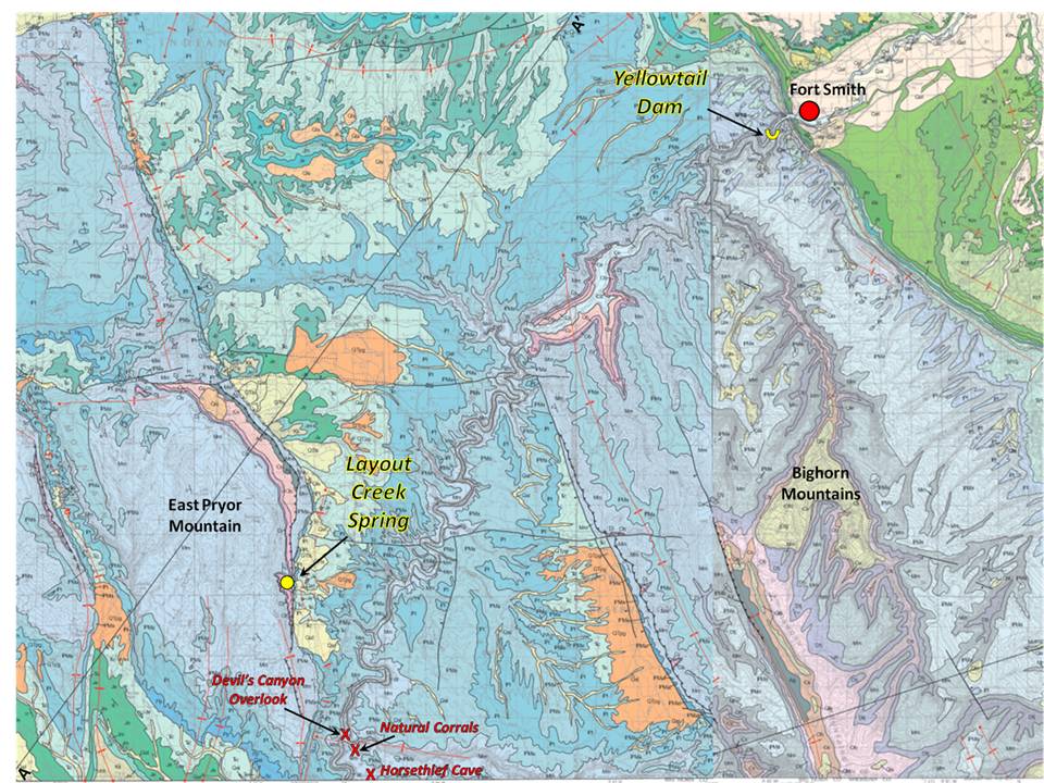
Geologic Map and Cross section of the Montana portion of Bighorn Canyon
Vuke et al., 2000 (Revised 2007), MBMG Geologic Map Series 56, https://mbmg.mtech.edu/mbmgcat/public/ListCitation.asp?pub_id=10211&; Lopez, D.A., 2000, MBMG Geologic Map Series 58, https://mbmg.mtech.edu/mbmgcat/public/ListCitation.asp?pub_id=10213&
Vuke et al., 2000 (Revised 2007), MBMG Geologic Map Series 56, https://mbmg.mtech.edu/mbmgcat/public/ListCitation.asp?pub_id=10211&; Lopez, D.A., 2000, MBMG Geologic Map Series 58, https://mbmg.mtech.edu/mbmgcat/public/ListCitation.asp?pub_id=10213&
Geologic Map of the Wyoming portion of Bighorn Canyon.
Pierce, W.G., 1997, USGS Miscellaneous Geologic Investigations Map I-2500 http://ngmdb.usgs.gov/Prodesc/proddesc_13047.htm
Pierce, W.G., 1997, USGS Miscellaneous Geologic Investigations Map I-2500 http://ngmdb.usgs.gov/Prodesc/proddesc_13047.htm
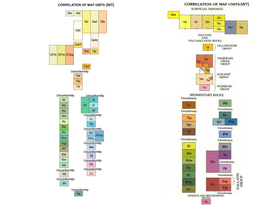
Map units for the Montana and Wyoming geologic maps.
MT: Vuke et al., 2000 (Revised 2007), MBMG Geologic Map Series 56, https://mbmg.mtech.edu/mbmgcat/public/ListCitation.asp?pub_id=10211&; & Lopez, D.A., 2000, MBMG Geologic Map Series 58, https://mbmg.mtech.edu/mbmgcat/public/ListCitation.asp?pub_id=10213&
WY: Pierce, W.G., 1997, USGS Miscellaneous Geologic Investigations Map I-2500 http://ngmdb.usgs.gov/Prodesc/proddesc_13047.htm
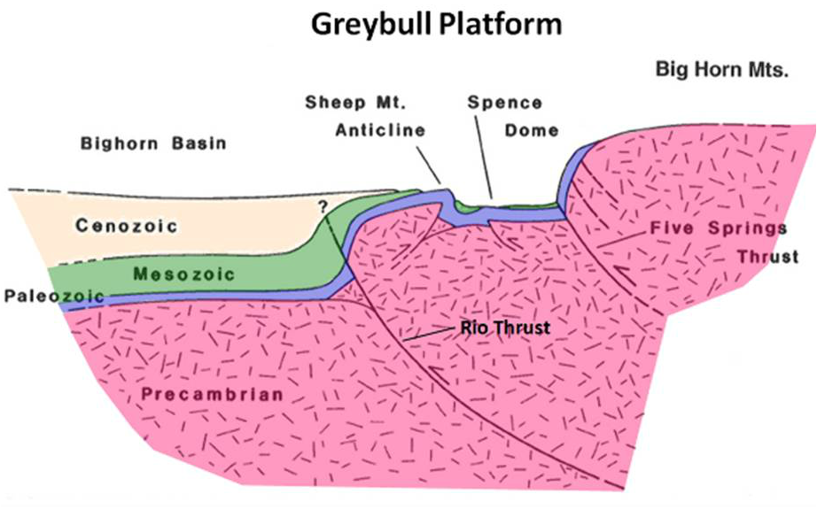
Geologic Cross Section west to east of the Greybull Platform, Wyoming about 15 miles south of Bighorn Canyon. The Bighorn River meandered north on the Greybull Platform and became entrenched at Sheep and Little Sheep Mountain anticlines before reaching Bighorn Canyon area.
After Foster, A., Irmen, A.P. and Vondra, C., 2003, WGA Guidebook, Fig. 8, p. 248.
After Foster, A., Irmen, A.P. and Vondra, C., 2003, WGA Guidebook, Fig. 8, p. 248.
Bighorn Canyon stratigraphy. Note erosion surface at the top of the Madison Formation (A) and the regional solution collapse zone at the A-B boundary. An abandoned meander channel (yellow highlight) of the Paleo-Bighorn River is perched on the canyon wall. Pa = Pennsylvanian Amsden Formation; Mm = Mississippian Madison Formation; A-D = informal subzones; Dtfj = Devonian Three Forks & Jefferson Formations.
Modified from: https://www.nps.gov/bica/learn/management/upload/2012-08-27_FinalDocument_Update-StdRes.pdf
Modified from: https://www.nps.gov/bica/learn/management/upload/2012-08-27_FinalDocument_Update-StdRes.pdf
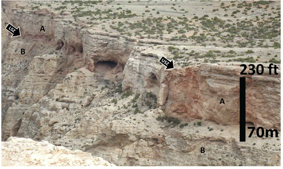
Close-up of the regional solution zones (arrows) displaying an assemblage of karst, caves, rock shelters and breccia zones. These layers are continuous throughout the Bighorn Basin and makes an excellent marker beds for correlation.. They are also the source of lost circulation zones and bit drops when drilling the Madison Formation. USZ: Upper solution zone; LSZ: Lower solution zone.
After Yobo, L.L.N., 2014, Origin and Distribution of the Mississippian – Pennsylvanian Boundary Unconformity in Marine Carbonate Successions with a Case Study of the Karst Development Atop the Madison Formation in the Bighorn Basin, Wyoming: Ph.D. Dissertation, University of Nebraska-Lincoln, Fig. 7, p. 65. http://digitalcommons.unl.edu/geoscidiss/59/
After Yobo, L.L.N., 2014, Origin and Distribution of the Mississippian – Pennsylvanian Boundary Unconformity in Marine Carbonate Successions with a Case Study of the Karst Development Atop the Madison Formation in the Bighorn Basin, Wyoming: Ph.D. Dissertation, University of Nebraska-Lincoln, Fig. 7, p. 65. http://digitalcommons.unl.edu/geoscidiss/59/
Mississippian Madison stratigraphic chart with regional paleogeographic map.
After Steele, K.K. (Compiler), 2014, Unpublished Bighorn Basin Field Trip Guidebook.
After Steele, K.K. (Compiler), 2014, Unpublished Bighorn Basin Field Trip Guidebook.
The geologic structure of the mountains and anticlines in the area were generated during the Laramide Orogeny (70 to 50 Ma). The folds are created by basement rock elevated along faults.
The “Monocline” is a thrust generated fold with 1,600 feet of relief in Paleozoic rocks, northern Bighorn Canyon.
After Maher, L. J., 1966, Photos 132-22. ftp://ftp.geology.wisc.edu/maher/air/132-20k2.jpg
After Maher, L. J., 1966, Photos 132-22. ftp://ftp.geology.wisc.edu/maher/air/132-20k2.jpg
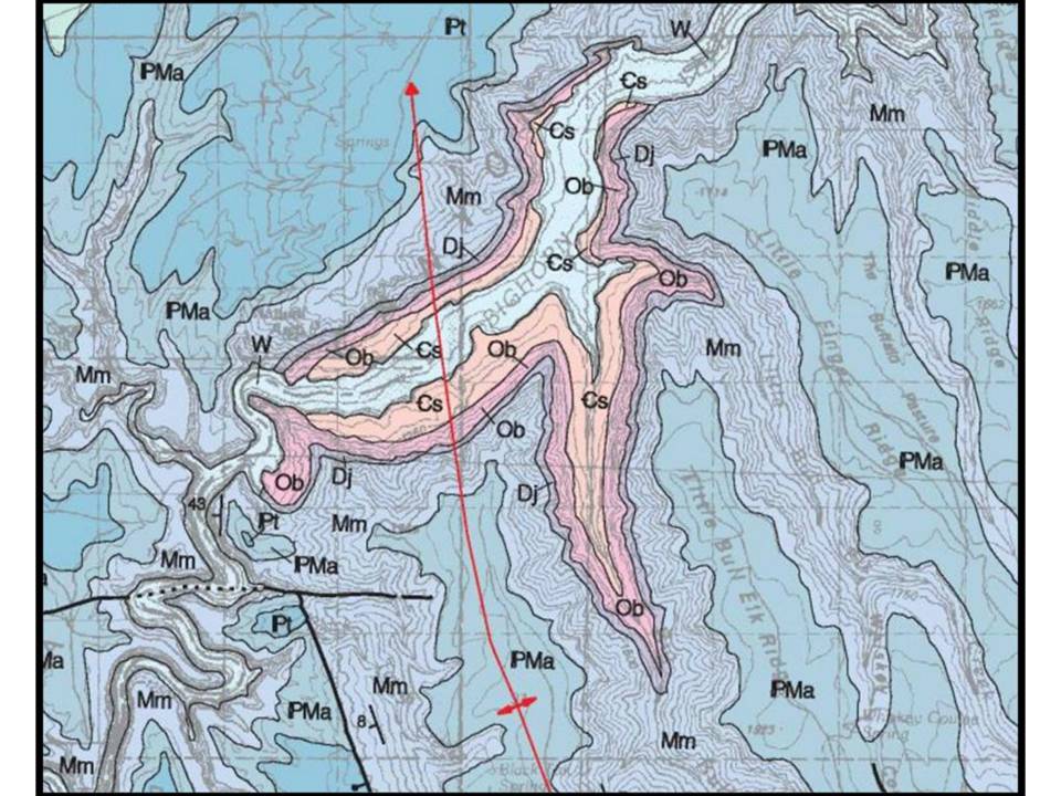
Geologic map of a northward plunging anticlinal fold located in the northern Bighorn Canyon area.
Image: Lopez, D.A., 2000, Geologic map of the Bridger 30'x60' quadrangle, Montana: Montana Bureau of Mines and Geology, Geologic Map GM-58, scale 1:100,000. http://www.mbmg.mtech.edu/pdf_100k/bridger-gm58.pdf
Image: Lopez, D.A., 2000, Geologic map of the Bridger 30'x60' quadrangle, Montana: Montana Bureau of Mines and Geology, Geologic Map GM-58, scale 1:100,000. http://www.mbmg.mtech.edu/pdf_100k/bridger-gm58.pdf
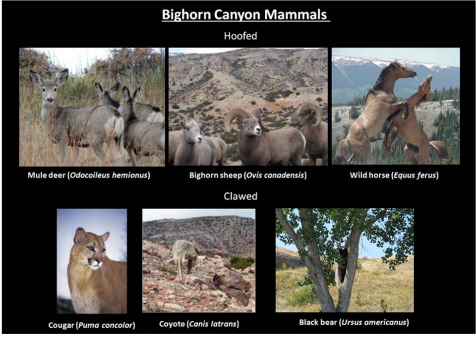
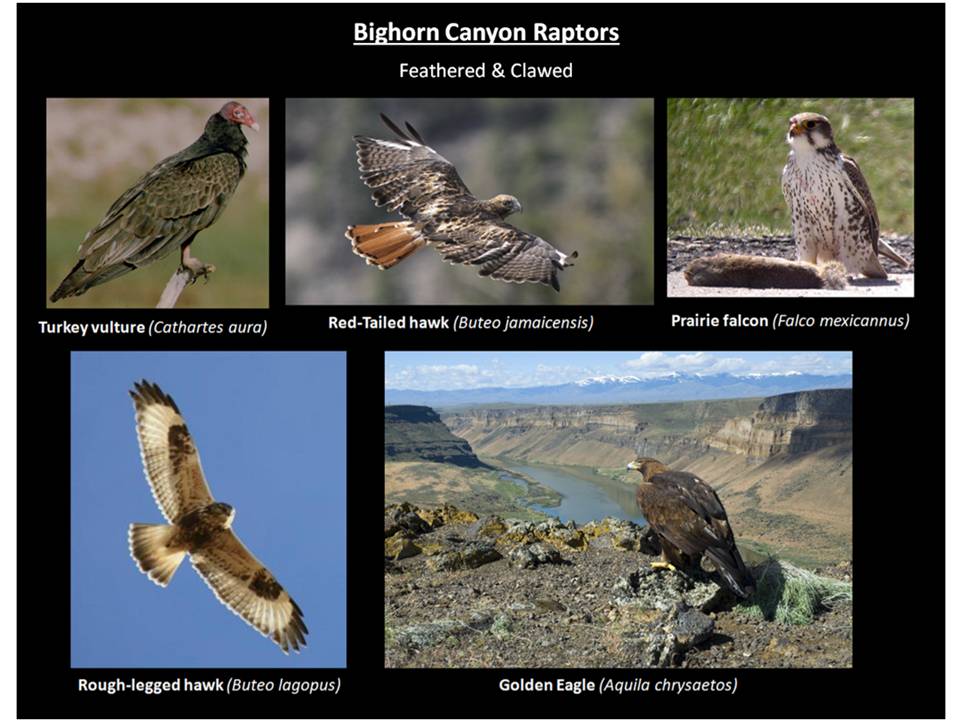
The scenic beauty of the canyon is enhanced by the abundant wildlife that live here. These animals include several large mammal and raptor species that often can be viewed from the turnouts along WY-37.
Wildlife of the Bighorn Canyon Area.
All images from National Park Service Photographic Library except Golden Eagle Image: Public domain, photo by Aldis Garsvo
All images from National Park Service Photographic Library except Golden Eagle Image: Public domain, photo by Aldis Garsvo
Things To Do At Bighorn Canyon
It is a 20 minute drive from Lovell to the entrance of Bighorn Canyon National Recreation Area (entrance fee $5). If you have a boat, most people put in at Horseshoe Bend that has nice facilities and a beach with a lifeguard. The other put-in option is Barry’s Landing. Commercial excursion boat trips into the canyon leave from Horseshoe Bend in the summer. Devil’s Canyon overlook is a must see and it has lots of railing at the cliff edge for protection. About 0.8 miles north of the Devil’s Canyon turnoff is a one-way turnoff and parking lot for the Sullivan’s Knob trail, a one mile round trip hike to the edge of the canyon. There is no railing on this trail, so use your own good judgment and do not get too close to the canyon rim. You can shout for echoes off the canyon walls at Devil’s Canyon overlook and Sullivan’s Knob trail. If you are looking for a moderate hike, we highly recommend Upper Layout Creek that has a canyon, small waterfall and a gem of a spring issuing from the base of the carbonate cliffs shaded by trees. An additional nearby easy hike is Lower Layout Creek that has spectacular views of the Bighorn Canyon and Lower Layout Creek Canyon. Our last suggestions are short walks to see tipi rings and the remains of both the Hillsboro/Cedarvale Dude Ranch and the Lockhart Ranch. Unless you are on the water, the afternoon summer heat and sun can be brutal at Bighorn Canyon. So time your visit to match your planned activity. You may also encounter rattlesnakes anywhere in Bighorn Canyon.
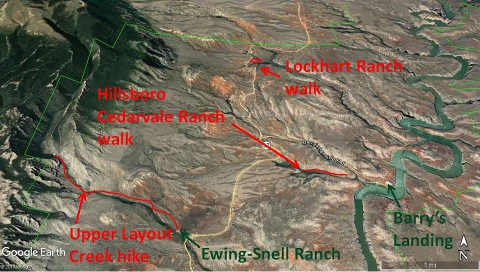
Map of Bighorn Canyon hikes at Upper Layout Creek, Hillsboro-Cedarvale Dude Ranch and Lockhart Ranch
Image by Google Earth
Image by Google Earth
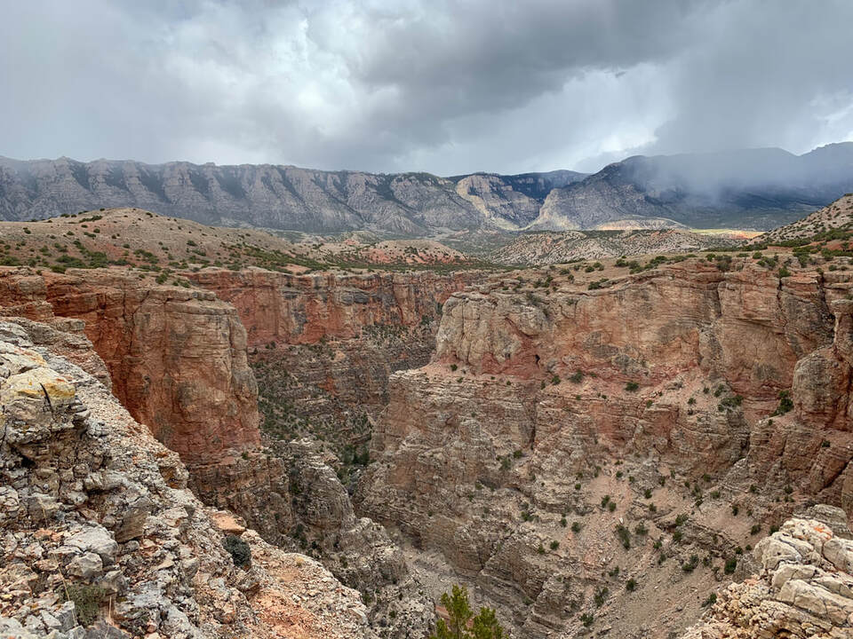
View of Lower Layout Creek Canyon. A relatively flat hike of about 4 miles total round trip with spectacular views of the Bighorn Canyon and Lower Layout Creek Canyon. There are no railings on this trail, so be extra cautious near the canyon rims.
Image by Mark Fisher
Image by Mark Fisher
Directions to Bighorn Canyon
Starting at the only traffic light in downtown Lovell at the intersection of Main (US 14A, US 310) and Nevada, go east on US 14A toward Greybull, 0.5 miles turn left on US 14A heading east to Burgess Junction, 0.6 miles Bighorn Canyon National Recreation Area Visitor Center on right, 0.8 miles Mustang Visitor Center on right, 2.9 miles turn left on WY 37 to Bighorn Canyon, 3.8 miles bentonite processing plant on right with mounds of grey bentonite which is “the clay of 1,000 uses” http://www.wsgs.wyo.gov/products/wsgs-2014-bentonite-summary.pdf, 4.1 miles cross Shoshone River, 7.0 miles shale hills on left are Cretaceous Mowry shale that contains numerous bentonite beds that are the result of volcanic ash falls , 11.8 miles intersection with Crooked Creek Road on left which is an access road to the Pryor Mountains, 12.4 miles park entrance fee station, 12.6 miles turnoff on right is Horseshoe Bend Marina, 13.0 miles on right are red shales and siltstones of the Triassic Chugwater Formation, 16.1 miles Wyoming-Montana border, 18.2 miles turnoff right for Devil’s Canyon Overlook, 19.0 miles turnoff right for one-way loop to parking lot for Sullivan’s Knob Trail to canyon rim, 22.1 miles parking on right for short walk to see tipi rings, 22.7 miles turnoff on left for Ewing-Snell Ranch with hike up Layout Creek, 25.3 miles Barry’s Landing turnoff on right with one mile round trip hike to Hillsboro/Cedarvale Ranch, 25.4 miles pavement ends, 27.8 miles Lockhart Ranch parking on left.
Upper Layout Creek Hike at Ewing-Snell Ranch
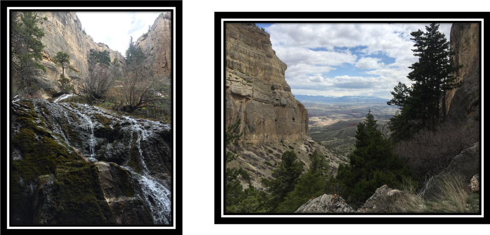
Left: Spring at Layout Creek. Right: View to southeast from Upper Layout Creek near spring. In middle distance is Ewing-Snell Ranch and Bighorn Canyon, in far distance are the Bighorn Mountains.
Photos by Mark Fisher
Photos by Mark Fisher
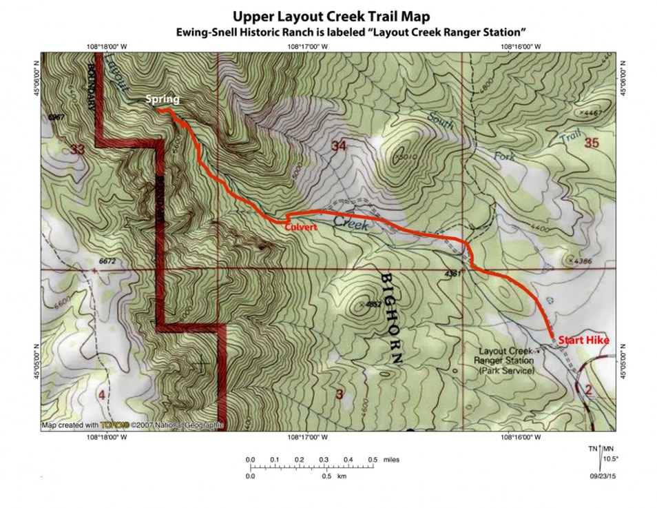
The Ewing-Snell Ranch is a turnoff on the left at 22.7 miles from the Lovell traffic light. Unfortunately, the main ranch house burned down in late-2015, so there are only a few out buildings to see at this time. The Park Service has plans to rebuild the ranch house. Layout Creek trail begins at a parking area just to the right of the corrals and climbs 1,300 vertical feet over 2.2 miles to a small waterfall and then a spring that is the main water source for Layout Creek. Picture a large spring issuing from the base of carbonate cliffs in a steep-sided canyon shaded by cottonwood and pine trees. Yeah, that is a pretty special spot! You should allocate 2-1/2 to 3 hours for the 4.4 mile round trip hike. The upper portion of the trail near the falls and spring is fairly steep with loose gravel, so take a hiking pole if you have one. The first 1.2 miles is on a gravel road that you can drive since there is no sign or gate prohibiting it. At 0.2 miles fence line, 0.6 miles irrigation pipe stand, 1.1 miles approximate position of fault running north south with upthrown side toward the mountain, 1.2 mile irrigation mound with cement pipe where there is room for only a couple of cars to park, 1.3 miles cross Layout Creek, 2.2 miles end of trail at spring. The Pryor Mountains located just to the west and north of the park tend to have minimal surface water in the creeks. This is because these mountains have thick outcrops of the Mississippian Madison and Ordovician Bighorn carbonates that are highly fractured and allow the rainwater and snowmelt to disappear deep into these two formations. There is a barrier of thick impermeable Cambrian shales immediately below the Bighorn carbonates that forms the base of this regional aquifer. Below the surface, water moves through the fractures and caves in the Madison and Bighorn carbonates. The spring at Layout Creek issues from the contact located at the base of the fractured Bighorn carbonates (cliffs) and the top of the impermeable Cambrian shales (covered slope). Late September and early October may be the best time to hike this trail with the Cottonwood leaves turning yellow and moderate temperatures. The pryormountain.org website has excellent pictures and description of the Upper Layout Creek hike.
Topographic map of Upper Layout Creek hike
Image: https://www.pryormountains.org/welcome-to-the-pryors/hiking-in-the-pryors/layout-creek/
Image: https://www.pryormountains.org/welcome-to-the-pryors/hiking-in-the-pryors/layout-creek/
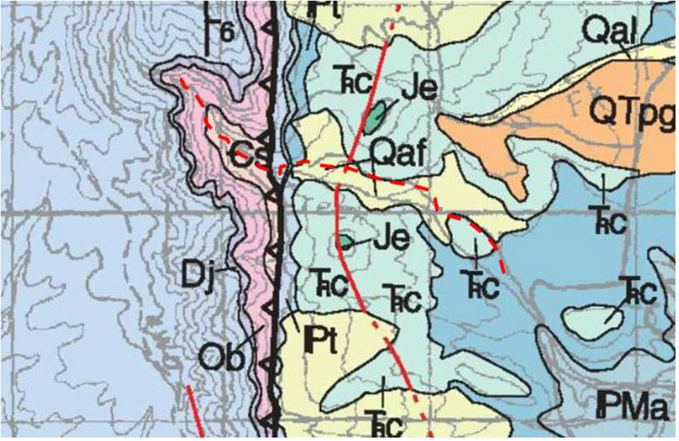
Geologic map of Upper Layout Creek hike. Red dashed line is hike.
Lopez, D.A., 2000, Geologic map of the Bridger 30'x60' quadrangle, Montana:MG Map GM-58, 1:100,000. Downloaded from USGS at The National Geologic Map Database; http://www.mbmg.mtech.edu/pdf_100k/bridger-gm58.pdf
Lopez, D.A., 2000, Geologic map of the Bridger 30'x60' quadrangle, Montana:MG Map GM-58, 1:100,000. Downloaded from USGS at The National Geologic Map Database; http://www.mbmg.mtech.edu/pdf_100k/bridger-gm58.pdf
Hillsboro and Cedarvale Dude Ranch Walk
In the early 1900’s, Dr. Berry tried to extract gold with a dredge from placer deposits where Trail Creek enters the Bighorn River. This was unsuccessful, so he switched his operation to dude ranching and advertised it as “The Sportsman’s Paradise of America”. You can walk among the empty ranch buildings that remain. It is a total 1.4 mile out and back relatively flat walk that will take about an hour. At 25.3 miles from Lovell, turn right off main road toward Barry’s Landing, after 0.2 miles burned area with small cliffs of Pennsylvanian Tensleep Sandstone on both sides of road, 1.0 miles campground with red shales of the Amsden Formation, 1.1 miles turn right for Hillsboro on gravel road, 1.5 miles gravel road splits and take right to parking area. Start hike at closed gate on gravel road, after walking for about 0.2 miles you reach a bench and kiosk that is on the upper contact of the Madison carbonates that was an exposed erosional surface back in the Mississippian. The small cliffs below the kiosk near corrals are Madison. The walk to Hillsboro is mainly in red shales of the Amden. Tensleep Sandstone form the ridge top to the left and right and many of the boulders are Tensleep Sandstone.
Lockhart Ranch Walk
Lockhart Ranch and East Pryor Mountain
Photo by Mark Fisher
Photo by Mark Fisher
Caroline Lockhart was 55 years old when she bought this 160 acre ranch with a couple of buildings in 1926. At that point, she had been a correspondent and columnist for the Boston Post, Philadelphia Bulletin and Denver Post, a writer of western novels some of which were made into movies, and owner and editor of the Cody Enterprise. She also helped start the annual July 4th celebration known as the Cody Stampede. It is safe to say she was an independent and determined woman. She owned the ranch for thirty years, adding buildings and purchasing adjoining properties until she controlled over 7,000 acres (about 11 square miles). This is the best preserved ranch within the Bighorn Canyon Recreation Area and certainly the most peaceful setting. At 27.8 miles from Lovell, park at the kiosk and toilet on the left, take the half-mile loop from the road down to the ranch, through the corrals and back up a dirt road to the starting point. We think you will like this short walk into another time.
Links
The Pryor Mountains by the Pryors Coalition - impressive website with detailed descriptions of hikes, cultural history, camping, natural history, maps and more.
Bighorn Canyon National Recreation Area - there is a nice hiking guide PDF download on their web page Plan Your Visit/ Things To Do/ Hiking
A twelve minute video on 'How the Bighorn Canyon Formed" can be viewed here: https://www.youtube.com/watch?v=3DRZKlXuZmw
Bighorn Canyon National Recreation Area - there is a nice hiking guide PDF download on their web page Plan Your Visit/ Things To Do/ Hiking
A twelve minute video on 'How the Bighorn Canyon Formed" can be viewed here: https://www.youtube.com/watch?v=3DRZKlXuZmw

The material on this page is copyrighted


