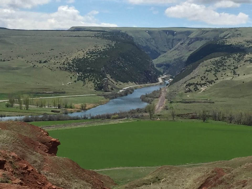
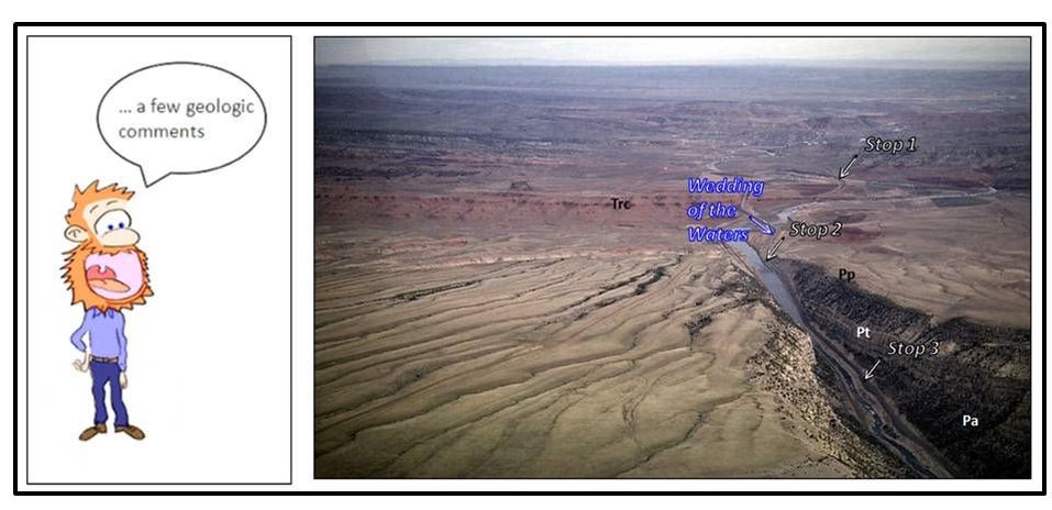
Wind River Canyon and the Wedding of the Waters where the Wind River changes name to the Bighorn River
Photo by Mark Fisher
Photo by Mark Fisher
Wow Factor (5 out of 5 stars):

Geologist Factor (5 out of 5 stars):

Attraction
It is the best place to see Paleozoic and Precambrian rocks in Wyoming because of great exposures and easy highway access. The Wind River Canyon is also one of the prettiest places in Wyoming with the high cliffs and clear flowing water. This is a special place and geology is the main event.
Geology of Wind River Canyon
The Wind River Canyon is a crack in time, 17 miles long, 200 to 3,000 feet wide and 2,500 feet deep. The road through the canyon has over 300 feet elevation climb southward and crosses rocks recording about 3 billion years in time.

Geologic map of Wind River Canyon with geologic stops numbered.
Image: After Lynds, R.M., 2013, WSGS Technical Memorandum 3, Plate 7, http://www.wsgs.uwyo.edu/Research/Energy/docs/CO2-Plates/Plate7.pdf
Image: After Lynds, R.M., 2013, WSGS Technical Memorandum 3, Plate 7, http://www.wsgs.uwyo.edu/Research/Energy/docs/CO2-Plates/Plate7.pdf
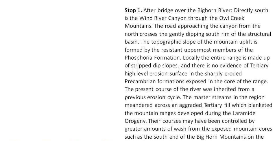
Wind River Canyon Road Log

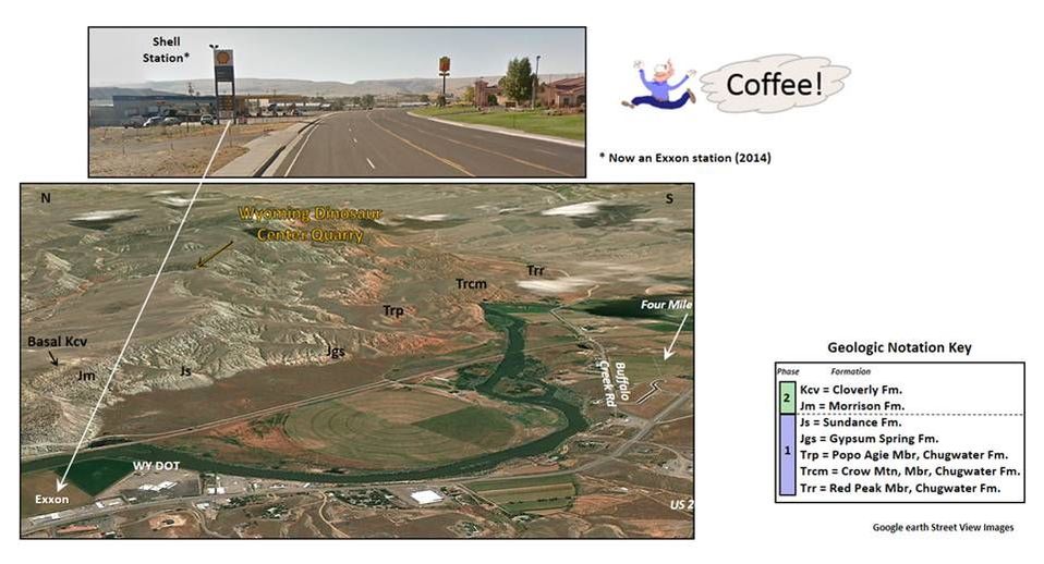
Top: Road log start at Exxon gas station, south end of Thermopolis. Bottom: East aerial view of the geology at first meander loop of the Bighorn River. Geologic notation shown in key to the right of image. Last chance for a cup of coffee and snacks inside store.
Images: After Google Earth Street View
Images: After Google Earth Street View

North aerial view of the Chugwater overlying the Owl Creek dip slope at the north portal of Wind River Canyon.
Image: Maher, L.J., Jr., 2002, Image 130-20
ftp://ftp.geology.wisc.edu/maher/air/130-20k2.jpg
Image: Maher, L.J., Jr., 2002, Image 130-20
ftp://ftp.geology.wisc.edu/maher/air/130-20k2.jpg
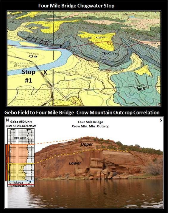
Stop 1: Four Mile Bridge. Top: Geologic map; Bottom: Crow Mountain Sandstone outcrop along Bighorn River. Correlation with Gebo Field subsurface log on left.
Images: Top: Base: Google earth, Overlay: Maughan, E.K., 1972, Geologic map of the Wedding of the Waters quadrangle, Hot Springs County, Wyoming: U.S. Geological Survey, Geologic Quadrangle Map GQ-1042, scale 1:24,000. Bottom: Google Earth, Panoramio, Photo, 2010 at http://www.panoramio.com/photo/34832365; Log from Wyoming Oil and Gas Conservation at http://wogcc.state.wy.us/legacywogcce.cfm
Images: Top: Base: Google earth, Overlay: Maughan, E.K., 1972, Geologic map of the Wedding of the Waters quadrangle, Hot Springs County, Wyoming: U.S. Geological Survey, Geologic Quadrangle Map GQ-1042, scale 1:24,000. Bottom: Google Earth, Panoramio, Photo, 2010 at http://www.panoramio.com/photo/34832365; Log from Wyoming Oil and Gas Conservation at http://wogcc.state.wy.us/legacywogcce.cfm
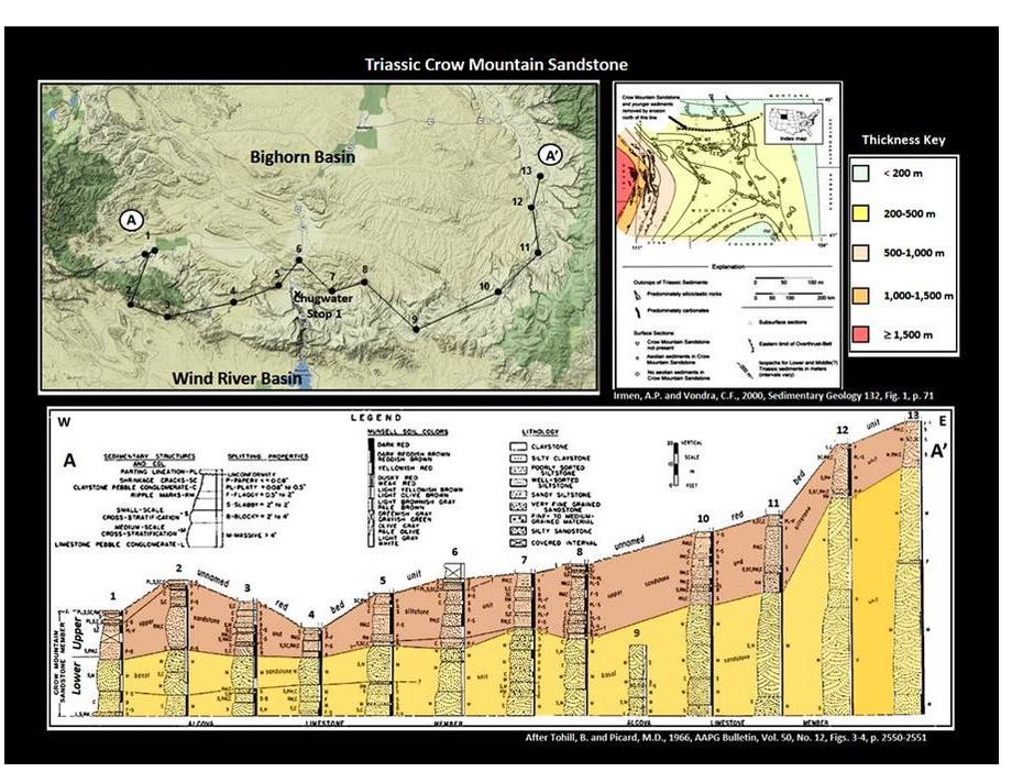
Crow Mountain Sandstone Member of the Triassic Chugwater Formation southern Bighorn Basin outcrop cross section and regional Wyoming thickness map.
Images: Cross section: After Tohill, B. and Picard, M.D., 1966, AAPG Bulletin, Vol. 50, No. 12, Figs. 3-4, p. 2550-2551; Isopach Map: After Irmen, A.P. and Vondra, C.F., 2000, Sedimentary Geology 132, Fig. 1, p. 71
Images: Cross section: After Tohill, B. and Picard, M.D., 1966, AAPG Bulletin, Vol. 50, No. 12, Figs. 3-4, p. 2550-2551; Isopach Map: After Irmen, A.P. and Vondra, C.F., 2000, Sedimentary Geology 132, Fig. 1, p. 71
The Chugwater Formation consists of four members in the Bighorn and Northern Wind River Basin area: Popo Agie, Crow Mountain, Alcova, and Red Peak. These units were deposited across an area that was located on the western edge of the continent of Pangea. The Chugwater beds are part of the larger Cordilleran Triassic red bed sequence deposited in the Rocky Mountain area.
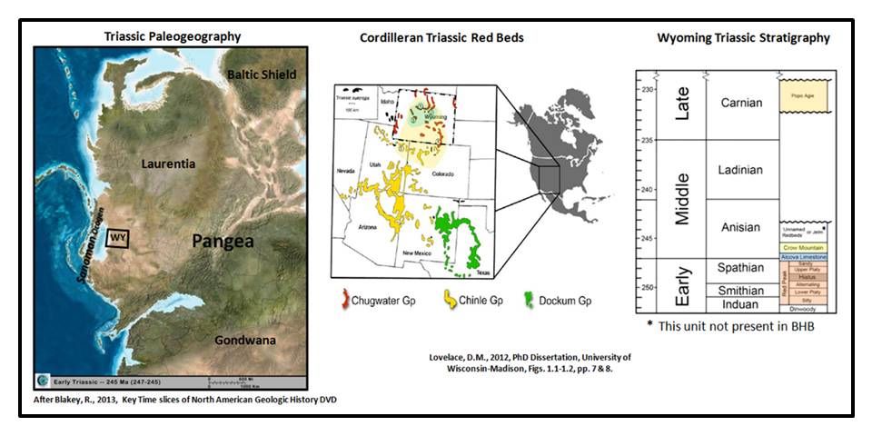
Triassic Paleogeography, Cordilleran Red Bed sequence and Wyoming Stratigraphy of the Chugwater Formation.
Images: Left: After Blakey, R., 2013, Key Time slices of North American Geologic History DVD, Center & Right: Lovelace, D.M., 2012, PhD Dissertation, University of Wisconsin-Madison, Figs. 1.1-1.2, pp. 7 & 8.
Images: Left: After Blakey, R., 2013, Key Time slices of North American Geologic History DVD, Center & Right: Lovelace, D.M., 2012, PhD Dissertation, University of Wisconsin-Madison, Figs. 1.1-1.2, pp. 7 & 8.
The Red Peak is the oldest and thickest unit. This red bed sequence was deposited on the wide shelf developed in Wyoming at a paleolatitude of 30o north. Salt casts, gypsum veins, mud cracks and scarce fossils suggest the climate was warm and semiarid to arid.
Left: Red Peak outcrop on west (R/L) side of US 20. Right: Gypsum veins in shale layers.
Images: Left: http://kgbudge.com/essays/Excellent/Photos/2014/07/07/DSCI0629.JPG; Right: https://en.wikipedia.org/wiki/File:Chugwater_gypsum_veins.jpg
Images: Left: http://kgbudge.com/essays/Excellent/Photos/2014/07/07/DSCI0629.JPG; Right: https://en.wikipedia.org/wiki/File:Chugwater_gypsum_veins.jpg
The Alcova member is a marine carbonate tongue of the Thaynes Limestone deposited along the Wyoming shelf in the southwestern corner of the state. Limited presence of stromatolitic algae and mollusk fauna indicate a restricted marine environment of deposition.
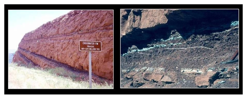
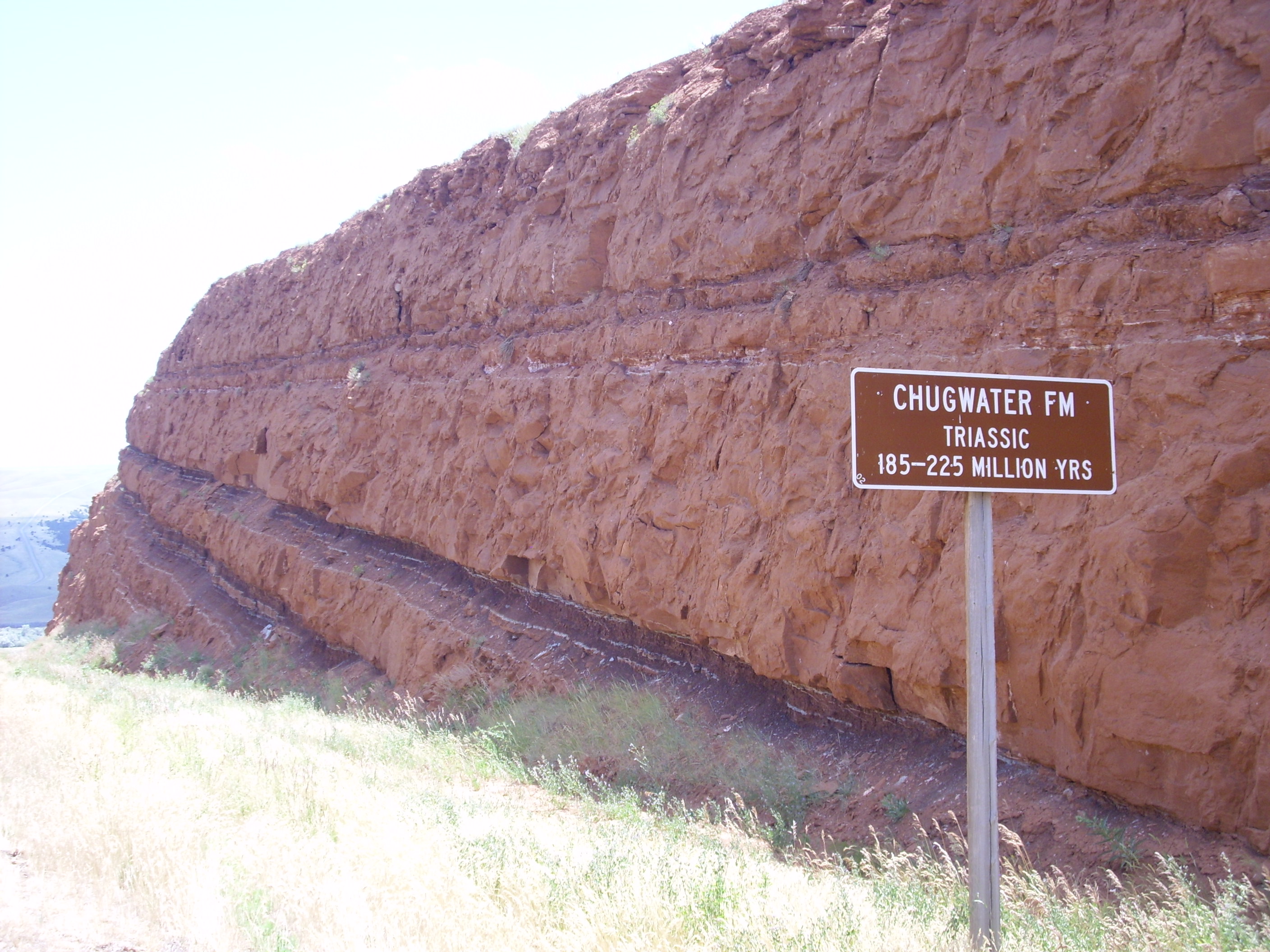
The Crow Mountain member consists of a basal sandstone and an upper sandstone/siltstone sequence. It is economically important as a hydrocarbon reservoir. Oil was discovered at Hamilton Dome Field (formerly Cottonwood Anticline) in 1918. Drillers called this pay sand “Curtis” after the manager of Empire Oil who made the discovery. The Crow Mountain Member was not formally recognized until 1939 (J.D. Love PhD Dissertation).
The Popo Agie member overlies the rest of the Chugwater with an over 10 million year unconformity. It is composed of clastics deposited in a river/lake environment. It represents one of the largest known ancient lakes which extended into large portions of four States (ID, WY, CO & UT).
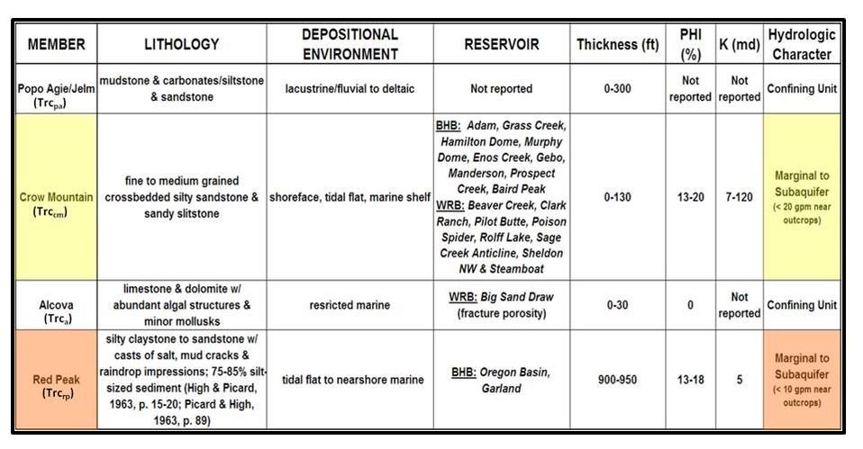
Summary table of Chugwater stratigraphy.
Image: Steele, K.K., 2012, Chugwater Stratigraphy after Taucher et al., 2012, Wind/Bighorn River Basin Water Plan Update Groundwater
Image: Steele, K.K., 2012, Chugwater Stratigraphy after Taucher et al., 2012, Wind/Bighorn River Basin Water Plan Update Groundwater
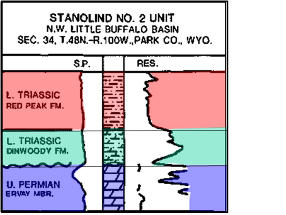
Subsurface electric log displaying typical resistivity response for the Red Peak, Dinwoody and Upper Phosphoria units. The log signature indicates that the Dinwoody Formation in the well is a dolomitic siltstone. Four points to note on Dinwoody log character: 1. the base line SP, 2. the higher resistivity than overlying Red Peak, 3. the lower resistivity than underlying carbonate of the Phosphoria, 4. the erratic distribution of anhydrite marker beds throughout the formation.
Well cuttings often show a color change from red to greenish from the Red Peak to the Dinwoody and an increase in disseminated pyrite.
Image: After Paull, R.A. and Paull, R. K., 1986, MGS, Fig. 9, p.18.
Well cuttings often show a color change from red to greenish from the Red Peak to the Dinwoody and an increase in disseminated pyrite.
Image: After Paull, R.A. and Paull, R. K., 1986, MGS, Fig. 9, p.18.
The early Triassic Dinwoody Formation represents the most northeastern extent of the Griesbachian (251 million years ago) seaway advance onto the Wyoming shelf. The north-south trending depositional limit of the formation is on the east side of the Bighorn Basin where the Dinwoody and Phosphoria interfinger with the Goose Egg Formation. Maximum thickness of the unit is found along the south flank of the Owl Creek Mountains and is under 100 feet. The formation is generally 60 to 65 feet thick within the Bighorn Basin and serves as a part of the Dinwoody-Chugwater-Gypsum Spring regional seal for the large Paleozoic oil accumulations in the Bighorn Basin. Four gradational lithologies make up the formation: dolomitic siltstone, gypsum, silty dolomite and sandstone. These rocks were deposited in a normal marine in the west to a shallow, low energy, hypersaline shelf at the seaway margin (eastern Bighorn Basin).
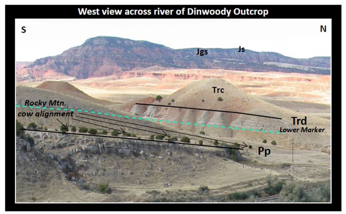
View of Dinwoody outcrop on the west side of the Wind River at north mouth of Wind River Canyon, NOTE: Rocky Mountain Bovimatry – cows show northward alignment with the earth’s magnetic field. Bovimatry is a lesser used geophysical technique that is today somewhat out of favor.
Image: Steele, K.K., 2009, Dinwoody at the mouth of Wind River Canyon.
Image: Steele, K.K., 2009, Dinwoody at the mouth of Wind River Canyon.
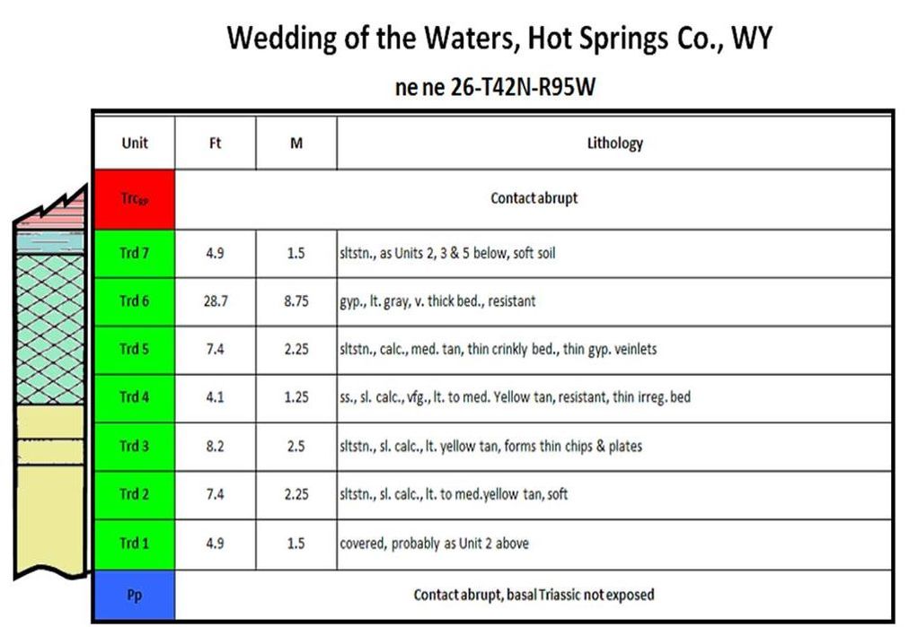
Dinwoody Formation outcrop description.
After Paull, R.A. and Paull, R.K., 1993, WGA, Stratigraphy of the Lower Triassic Dinwoody Formation in the Wind River Basin Area, Wyoming: Oil and Gas and Other Resources of the Wind River Basin, Wyoming; Special Symposium, Fig. 4, p. 35 & Table, p. 47.
After Paull, R.A. and Paull, R.K., 1993, WGA, Stratigraphy of the Lower Triassic Dinwoody Formation in the Wind River Basin Area, Wyoming: Oil and Gas and Other Resources of the Wind River Basin, Wyoming; Special Symposium, Fig. 4, p. 35 & Table, p. 47.
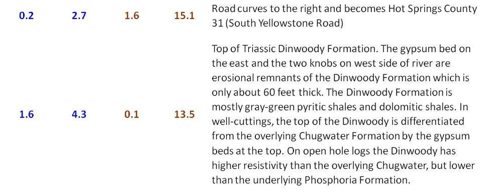
Interpretive signs about Wedding of the Waters are located about 0.4 miles north of the junction of WY Hwy 137 and US 20. When Lewis and Clark reached this stream in Montana they named it the Bighorn River after the abundant number of native sheep in the area. Native Americans named the same river to the south for the strong prevailing northwest winds blowing downstream between the Absaroka and Wind River mountains. The Wedding of the Waters, a half-mile to the south at the mouth of the canyon (top of Phosphoria), is the geographical point chosen for the name change. Wind River is applied to the stream’s upper reaches in the Wind River Basin, and Bighorn River from Wedding of the Waters northward.
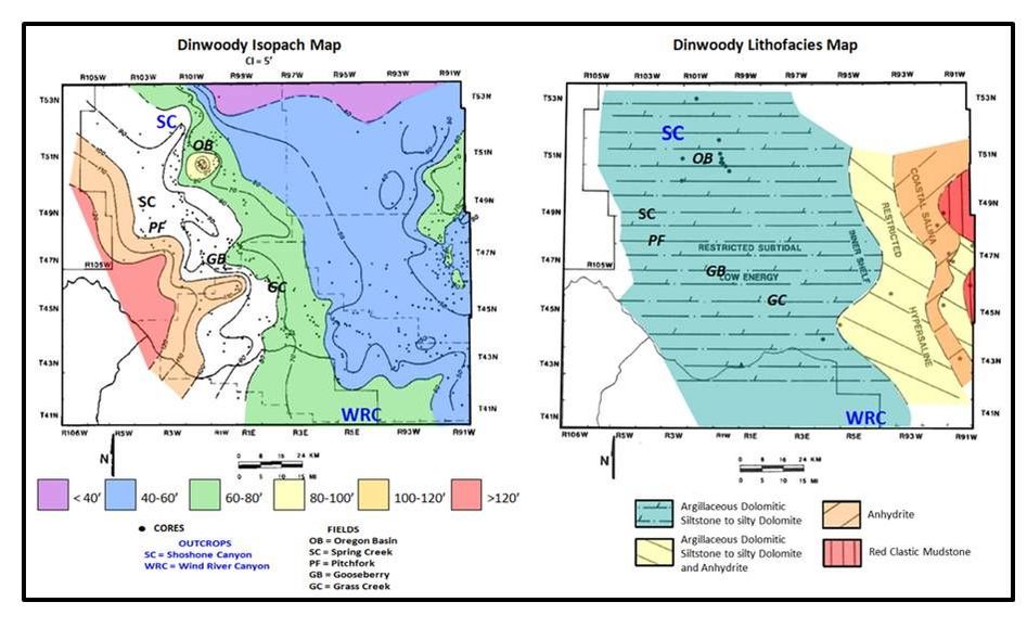
Dinwoody Formation Isopach and Lithology Maps for a portion of the Bighorn Basin.
Images: After Clark, W.J., 1994, An Integrated Sequence Stratigraphic Approach to Reservoir Characterization of the Lower Mississippian Madison Limestone, Emphasizing Elk Basin Field, Bighorn Basin, Wyoming: Ph.D. Dissertation, Colorado School of Mines, Fig. 61, p. 161 & Fig. 63, p. 165.
Images: After Clark, W.J., 1994, An Integrated Sequence Stratigraphic Approach to Reservoir Characterization of the Lower Mississippian Madison Limestone, Emphasizing Elk Basin Field, Bighorn Basin, Wyoming: Ph.D. Dissertation, Colorado School of Mines, Fig. 61, p. 161 & Fig. 63, p. 165.
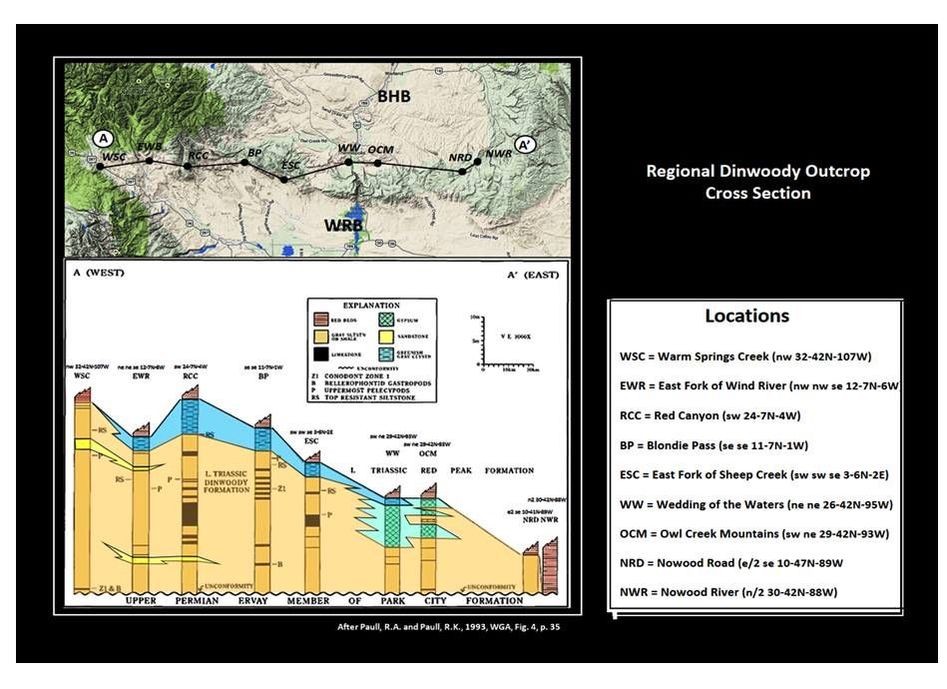
Regional Dinwoody Formation outcrop cross section along southern margin of Bighorn Basin.
Image: After Paull, R.A. and Paull, R.K., 1993, WGA, Fig. 4, p. 35
Image: After Paull, R.A. and Paull, R.K., 1993, WGA, Fig. 4, p. 35
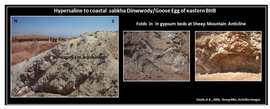
Hypersaline Dinwoody Formation at seaway margin at the north nose of Sheep Mountain Anticline.
Images: Steele, K.K., 2009, Sheep Mountain Anticline
Images: Steele, K.K., 2009, Sheep Mountain Anticline
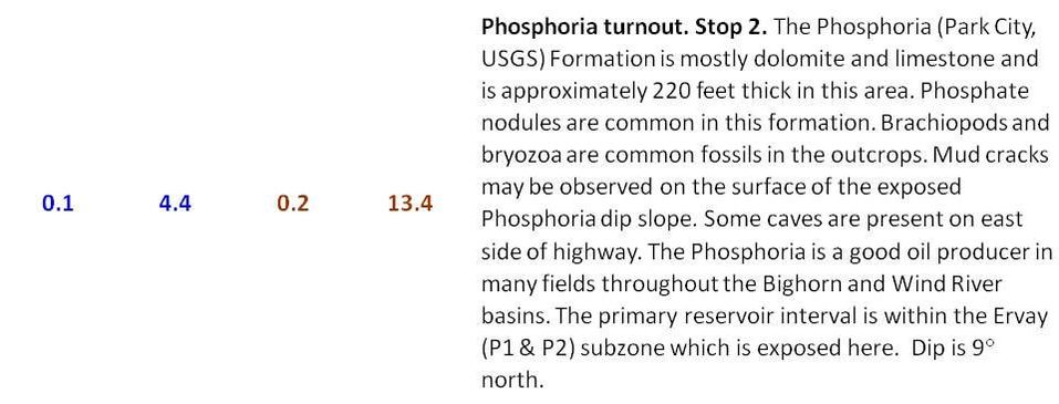
Ervay Member of the Phosphoria Formation, Wind River Canyon.
Image: After https://www.flickr.com/photos/wy_jackrabbit/4249397308/
Image: After https://www.flickr.com/photos/wy_jackrabbit/4249397308/
The boundary with the overlying Dinwoody Formation is a one to six million year unconformity that represents the greatest extinction event on the Earth. Up to 90% of marine organisms and 70% of land-based lifeforms perished. Reefs, chert, and coal or peat beds disappear from the geologic record. The Dinwoody is a time of global warming, acid rain, ocean acidification and anoxia.
The Phosphoria in Wind River Canyon is located at about the center of the Ervay Member of the Park City facies of the Permian rock complex. Three formations comprise this interfingering and laterally equivalent rock complex. The Phosphoria is the marine facies deposited in westernmost Wyoming and eastern Idaho and Utah. The Park City Formation is the middle facies deposited on the Wyoming shelf. The Goose Egg Formation is a sequence of continental redbeds and evaporites. Westward of the Wind River Canyon exposure the Ervay Member consists of marine carbonate, alternating with phosphatic siltstone and chert beds. Eastward the Ervay grades into restricted carbonates and terrestrial red beds.
The Phosphoria in Wind River Canyon is located at about the center of the Ervay Member of the Park City facies of the Permian rock complex. Three formations comprise this interfingering and laterally equivalent rock complex. The Phosphoria is the marine facies deposited in westernmost Wyoming and eastern Idaho and Utah. The Park City Formation is the middle facies deposited on the Wyoming shelf. The Goose Egg Formation is a sequence of continental redbeds and evaporites. Westward of the Wind River Canyon exposure the Ervay Member consists of marine carbonate, alternating with phosphatic siltstone and chert beds. Eastward the Ervay grades into restricted carbonates and terrestrial red beds.
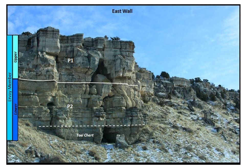
Subsurface geophysical log correlation to Wind River Canyon Permian outcrop section.
Images: Log: Wyoming oil and Gas Conservation website http://wogcc.state.wy.us/legacywogcce.cfm Outcrop description: After RPI, 1984, Tensleep/Phosphoria, Bighorn Basin, Outcrop Description Appendix.
Images: Log: Wyoming oil and Gas Conservation website http://wogcc.state.wy.us/legacywogcce.cfm Outcrop description: After RPI, 1984, Tensleep/Phosphoria, Bighorn Basin, Outcrop Description Appendix.
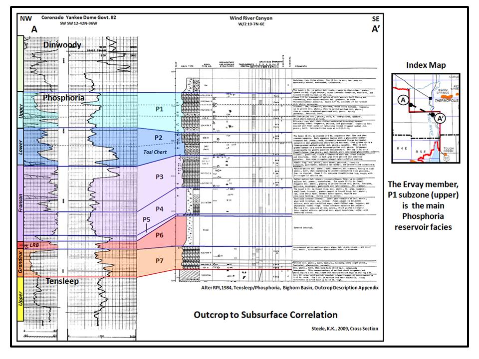
Ervay outcrop sedimentary features, Wind River Canyon.
Images: Rath, B.A., 1981, Stratigraphy and diagenesis of the Ervay member of the Park City and Goose Egg formations (Permian), eastern Wind River Basin, Wyoming: M.S. Thesis, Colorado School of Mines, Figs. 5, 19, 56 & 57, pp., 16, 34 & 12 https://dspace.library.colostate.edu/handle/11124/78294?show=full
Images: Rath, B.A., 1981, Stratigraphy and diagenesis of the Ervay member of the Park City and Goose Egg formations (Permian), eastern Wind River Basin, Wyoming: M.S. Thesis, Colorado School of Mines, Figs. 5, 19, 56 & 57, pp., 16, 34 & 12 https://dspace.library.colostate.edu/handle/11124/78294?show=full
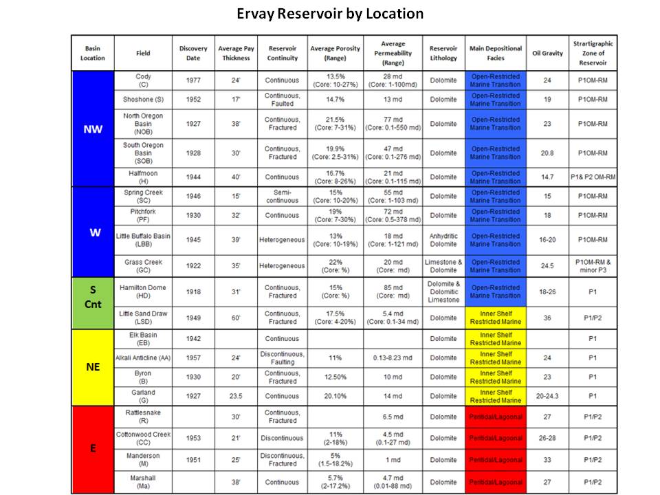
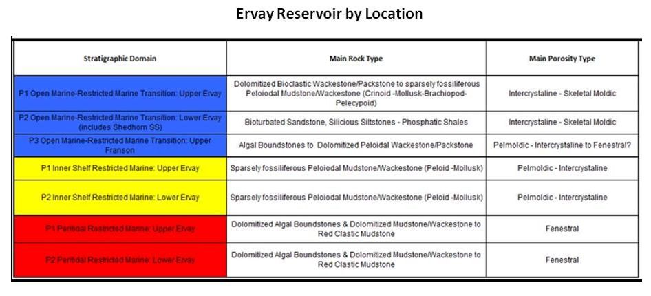
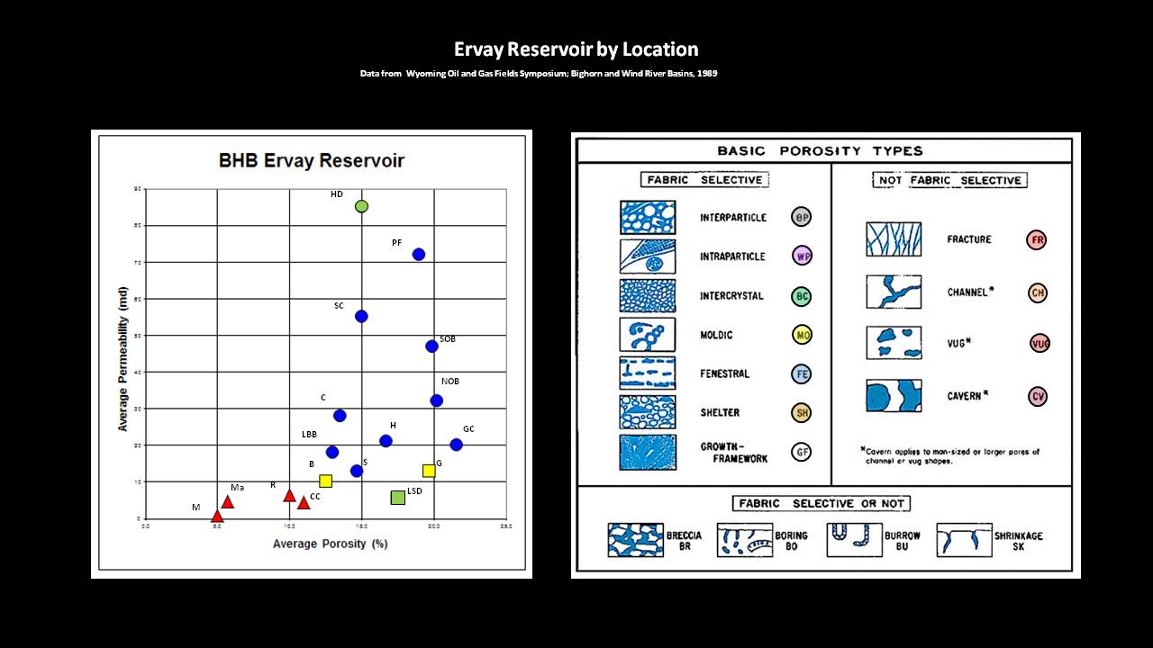
Phosphoria reservoir porosity and permeability development is a function of depositional facies.
Images: Left Tables: After Clark, W.J., 1994, An Integrated Sequence Stratigraphic Approach to Reservoir Characterization of the Lower Mississippian Madison Limestone, Emphasizing Elk Basin Field, Bighorn Basin, Wyoming: Ph.D. Dissertation, Colorado School of Mines. Bottom: Left:: Steele, K.K. (data from WGA, 1989) Bottom: Right: http://www.sepmstrata.org/page.aspx?&pageid=480&6
Images: Left Tables: After Clark, W.J., 1994, An Integrated Sequence Stratigraphic Approach to Reservoir Characterization of the Lower Mississippian Madison Limestone, Emphasizing Elk Basin Field, Bighorn Basin, Wyoming: Ph.D. Dissertation, Colorado School of Mines. Bottom: Left:: Steele, K.K. (data from WGA, 1989) Bottom: Right: http://www.sepmstrata.org/page.aspx?&pageid=480&6
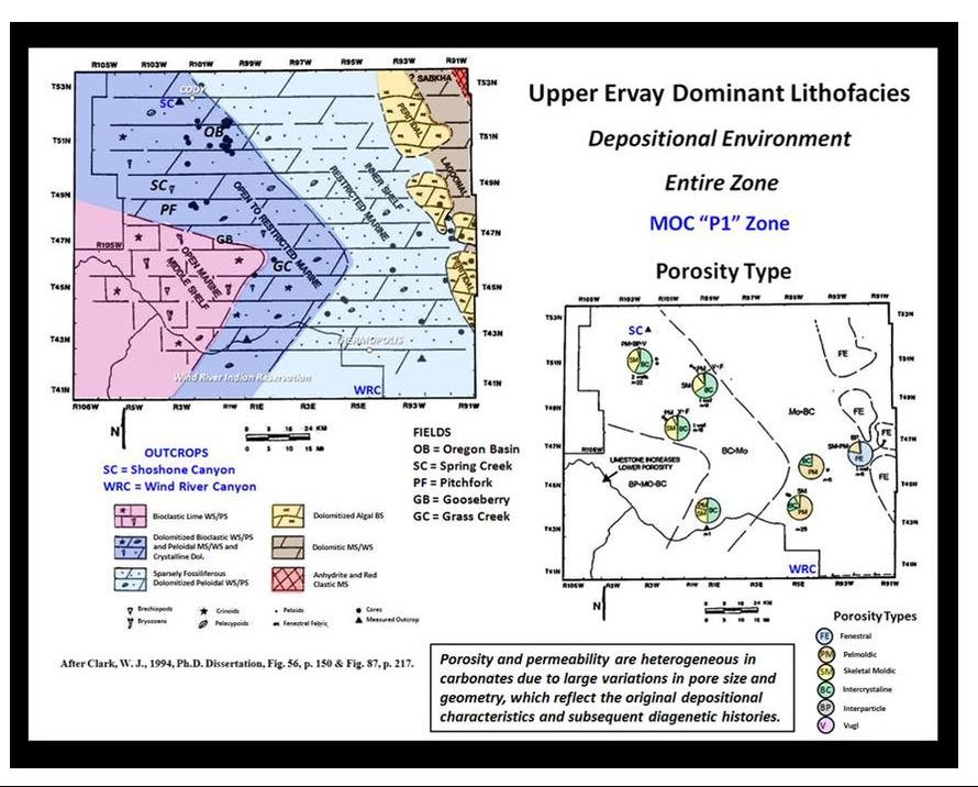
Upper Ervay (Phosphoria/Park City) dominant rock and porosity type maps.
Images: After Clark, W.J., 1994, An Integrated Sequence Stratigraphic Approach to Reservoir Characterization of the Lower Mississippian Madison Limestone, Emphasizing Elk Basin Field, Bighorn Basin, Wyoming: Ph.D. Dissertation, Colorado School of Mines, Fig. 56, p. 150 and Fig. 87, p. 217.
Images: After Clark, W.J., 1994, An Integrated Sequence Stratigraphic Approach to Reservoir Characterization of the Lower Mississippian Madison Limestone, Emphasizing Elk Basin Field, Bighorn Basin, Wyoming: Ph.D. Dissertation, Colorado School of Mines, Fig. 56, p. 150 and Fig. 87, p. 217.
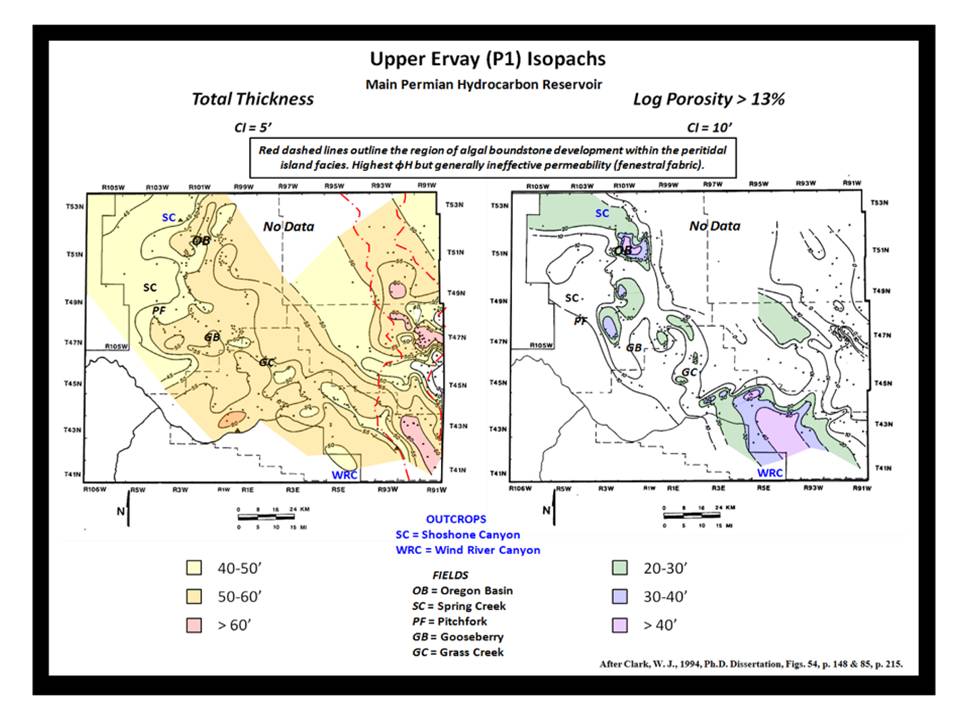
Upper Ervay (Phosphoria/Park City) thickness and porosity > 13% thickness maps.
Images: After Clark, W.J., 1994, An Integrated Sequence Stratigraphic Approach to Reservoir Characterization of the Lower Mississippian Madison Limestone, Emphasizing Elk Basin Field, Bighorn Basin, Wyoming: Ph.D. Dissertation, Colorado School of Mines, Fig. 56, p. 150 and Fig. 87, p. 217.
Images: After Clark, W.J., 1994, An Integrated Sequence Stratigraphic Approach to Reservoir Characterization of the Lower Mississippian Madison Limestone, Emphasizing Elk Basin Field, Bighorn Basin, Wyoming: Ph.D. Dissertation, Colorado School of Mines, Fig. 56, p. 150 and Fig. 87, p. 217.
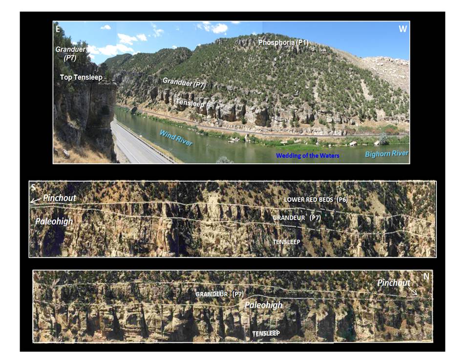
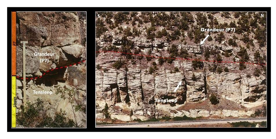
The Phosphoria/Tensleep contact on the west (R/L) side of the river. Lower two images are a south-to-north close-up of lateral pinchouts of the basal member of the Park City Formation (Grandeur Member of the Phosphoria Formation (P7)).
Images: Top: Steele, K.K., 2009, Pp/Pt Unconformity and Wedding of the Waters. Center and Bottom: After RPI, 1984, Tensleep/Phosphoria, Bighorn Basin.
Images: Top: Steele, K.K., 2009, Pp/Pt Unconformity and Wedding of the Waters. Center and Bottom: After RPI, 1984, Tensleep/Phosphoria, Bighorn Basin.
The Tensleep is part of a large Pennsylvanian-Permian dune complex that developed on the western edge of the Late Paleozoic continent of Pangea. The Tensleep Sandstone exposure in the canyon presents a depositional dip profile of most the entire formation. The rocks are informally divided into an upper, thick-bedded member, and a lower, thinner bedded member. The upper unit is about 230 feet of dominantly wind-blown, carbonate-cemented quartz sandstone with interbeds of dolomite or dolomitic sandstone. The 75 foot lower member consists of interbedded marine sandstones and carbonates with an occasional, reworked eolian deposit
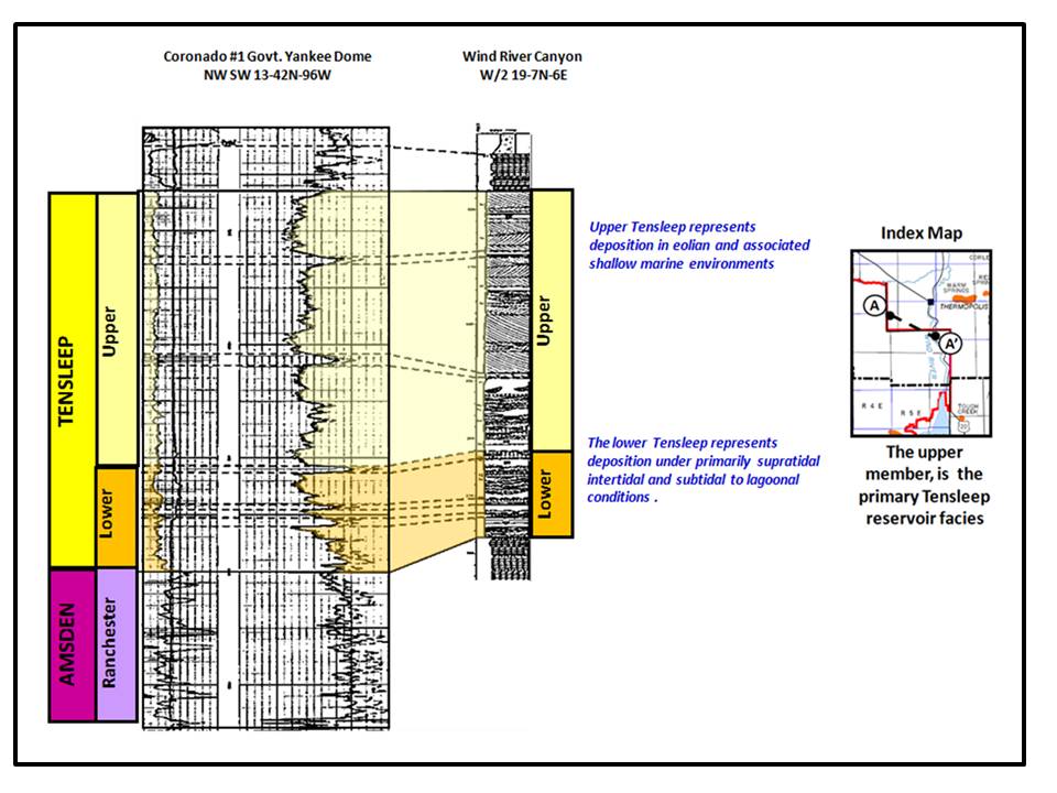
Subsurface geophysical log correlation to Wind River Canyon Tensleep outcrop section.
Image: After Inden et al., 1996, WGA Field Trip, Wind River Canyon, pp. 76-77.
Image: After Inden et al., 1996, WGA Field Trip, Wind River Canyon, pp. 76-77.
Phosphoria/Tensleep unconformity contact shown by dashed red line. Image to right shows Tensleep dunes climbing in the direction of wind transport. Here dune migration is from north to south (left to right).
Images: Left: After Wheeler, D., 1986, Stratigraphy and sedimentology of the Tensleep sandstone, southeast Bighorn Basin, Wyoming: M.S. Thesis, Colorado School of Mines, Fig. 19, p. 49, https://dspace.library.colostate.edu/handle/11124/170478, Right: After Wheeler, D., 1986, Ibid., Fig. 37, p. 80.
Images: Left: After Wheeler, D., 1986, Stratigraphy and sedimentology of the Tensleep sandstone, southeast Bighorn Basin, Wyoming: M.S. Thesis, Colorado School of Mines, Fig. 19, p. 49, https://dspace.library.colostate.edu/handle/11124/170478, Right: After Wheeler, D., 1986, Ibid., Fig. 37, p. 80.
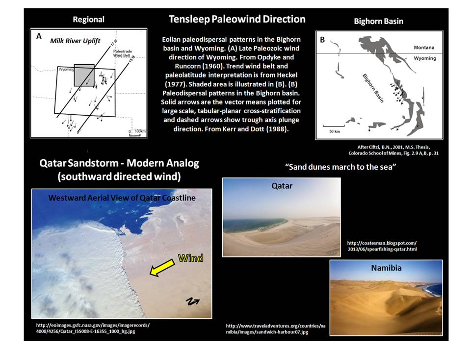
Tensleep sand dune depositional system paleowind and modern analogs.
Images: Top: After Ciftci, B.N., 2001, Outcrop-based 3-D modeling of the Tensleep sandstone at Alkali Creek, Bighorn Basin, Wyoming: M.S. Thesis, Colorado School of Mines, Fig. 2.9A, B, p. 31, https://dspace.library.colostate.edu/handle/11124/170531 ,
Bottom: Left: http://eoimages.gsfc.nasa.gov/images/imagerecords/4000/4256/Qatar,
Center: http://coatesman.blogspot.com/2013/06/spearfishing-qatar.html ,
Right: http://www.traveladventures.org/countries/namibia/images/sandwich-harbour07.jpg.
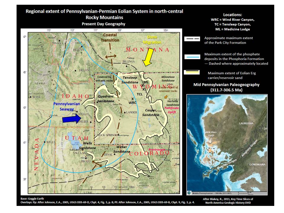
The Late Paleozoic sand dune complex on western Pangea.
Images: Left: Base: Google Earth, Data: Pp: After Johnson, E.A., 2005, USGS DDS-69-D, Chapter 4, Fig. 3, p. 8; Pt: After Johnson, E.A., 2005, USGS DDS-69-B, Chapter 9, Fig. 3, p. 4; https://pubs.usgs.gov/dds/dds-069/dds-069-d/reports.html, Right: After Blakey, R., 2011, NAM_key-308Ma_MPenn, Key Time Slices of North America Geologic History DVD
Images: Left: Base: Google Earth, Data: Pp: After Johnson, E.A., 2005, USGS DDS-69-D, Chapter 4, Fig. 3, p. 8; Pt: After Johnson, E.A., 2005, USGS DDS-69-B, Chapter 9, Fig. 3, p. 4; https://pubs.usgs.gov/dds/dds-069/dds-069-d/reports.html, Right: After Blakey, R., 2011, NAM_key-308Ma_MPenn, Key Time Slices of North America Geologic History DVD
The Tensleep is the largest oil reservoir in the state. The sandstone reservoir has excellent porosity and permeability distributed throughout the Bighorn Basin. Natural fractures present in the rock in the subsurface enhance the productivity of the reservoir. Much like the hot water system in a house, where the reservoir tank holds the water (Tensleep reservoir) and the plumbing delivers the water (Tensleep natural fracture system), fractures enhance oil movement in the subsurface.
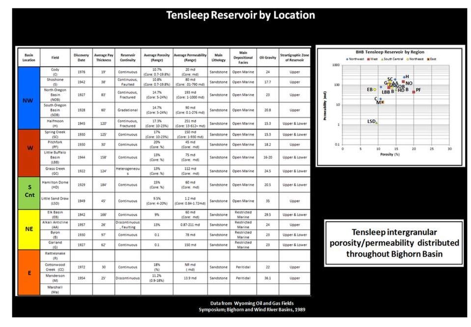
Tensleep reservoir characteristics by location in the Bighorn Basin.
Image: Steele, K.K. (data from WGA, 1989)
Image: Steele, K.K. (data from WGA, 1989)
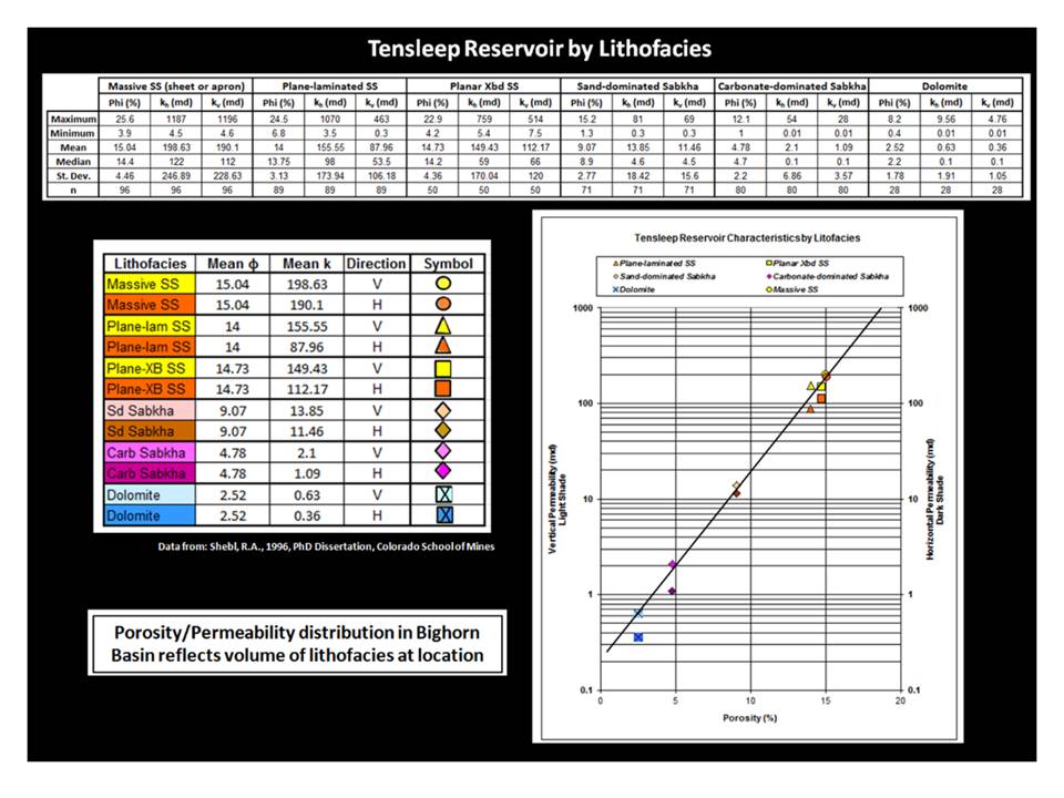
Tensleep reservoir characteristics by lithofacies development in the Bighorn Basin.
Image: Steele, K.K. (data from WGA, 1989)
Image: Steele, K.K. (data from WGA, 1989)
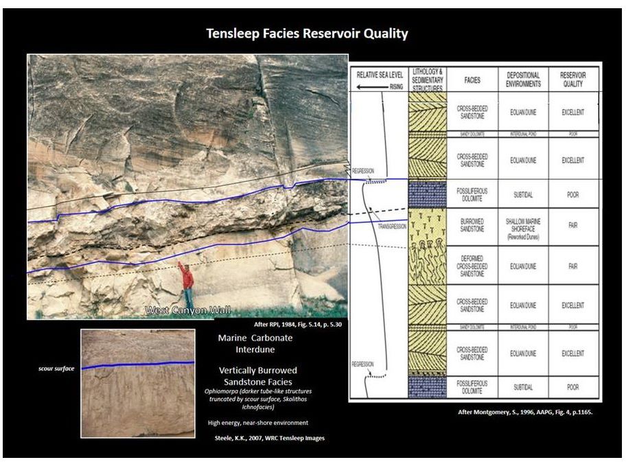
Upper Tensleep hydrocarbon reservoir properties, Wind River Canyon. Photo is about 0.3 miles south of the Phosphoria/Tensleep contact.
Images: Top Right: After RPI, 1984, Tensleep/Phosphoria, Bighorn Basin, Fig 5.14, p. 5.30; Right: After Montgomery, S., 1996, AAPG, Fig. 4, p.1165; Bottom Left: Steele, K.K., 2009, WRC Pt Image
Images: Top Right: After RPI, 1984, Tensleep/Phosphoria, Bighorn Basin, Fig 5.14, p. 5.30; Right: After Montgomery, S., 1996, AAPG, Fig. 4, p.1165; Bottom Left: Steele, K.K., 2009, WRC Pt Image
Natural fractures occur from stresses applied to the rock. Fracture characteristics reflect the rock properties of the formation and the orientation to the stress field. The majority of fractures found within the Permian and Pennsylvanian units resulted from the Laramide mountain building event that reached the Bighorn Basin about 70 million years ago.
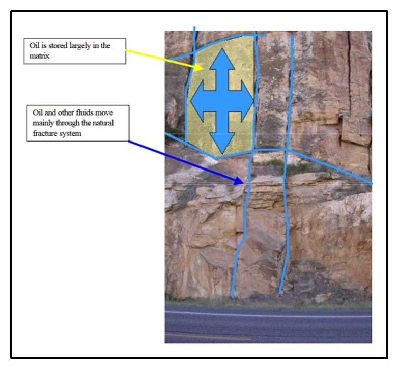
Outcrop of Tensleep Formation, Wind River Canyon, Wyoming, illustrating roles of matrix as storage and natural fractures as permeability.
Image: LaPointe et al., 2002, DOE Final Technical Report, Fig. 1.3 p.
Image: LaPointe et al., 2002, DOE Final Technical Report, Fig. 1.3 p.
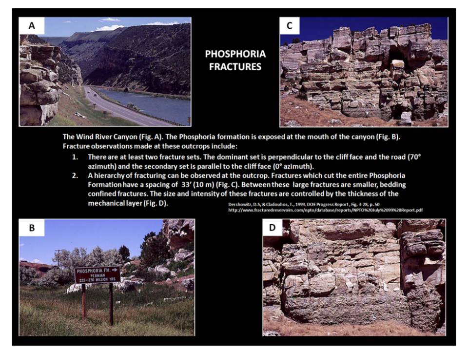
Laramide fractures exposed in Ervay Member of Permian Phosphoria Formation, Wind River Canyon.
Images: Dershowitz, D.S, & Cladouhos, T., 1999. DOE Progress Report, Fig. 3-28, p. 50 http://www.fracturedreservoirs.com/npto/database/reports/NPTO%20July%2099%20Report.pdf
Images: Dershowitz, D.S, & Cladouhos, T., 1999. DOE Progress Report, Fig. 3-28, p. 50 http://www.fracturedreservoirs.com/npto/database/reports/NPTO%20July%2099%20Report.pdf
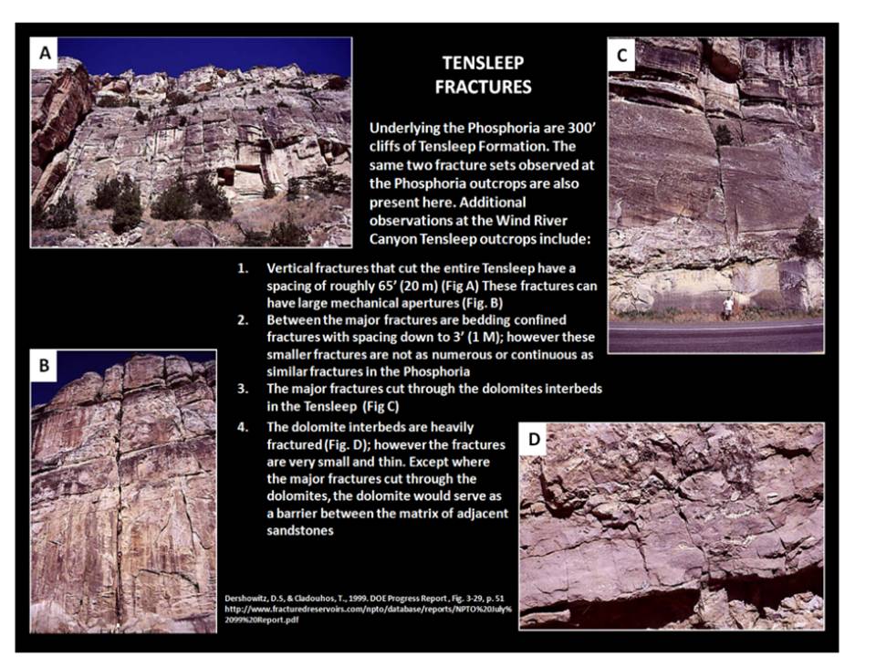
Laramide fractures exposed in the Pennsylvanian Upper Tensleep Formation, Wind River Canyon.
Images: Dershowitz, D.S, & Cladouhos, T., 1999. DOE Progress Report, Fig. 3-29, p. 51
http://www.fracturedreservoirs.com/npto/database/reports/NPTO%20July%2099%20Report.pdf
Images: Dershowitz, D.S, & Cladouhos, T., 1999. DOE Progress Report, Fig. 3-29, p. 51
http://www.fracturedreservoirs.com/npto/database/reports/NPTO%20July%2099%20Report.pdf

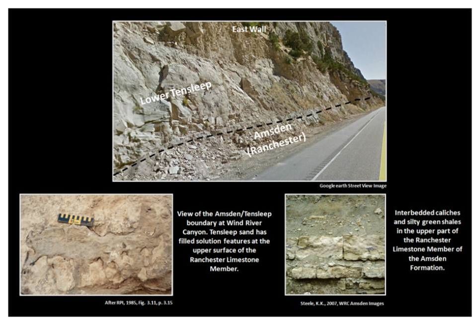
Tensleep/Amsden contact, Wind River Canyon.
Images: Top: Google Earth Street View; Bottom Left: After RPI, 1984, Tensleep/Phosphoria, Bighorn Basin, Fig. 3.11, p. 3.15; Right: Steele, K.K., 2009, WRC Pa Image.
Images: Top: Google Earth Street View; Bottom Left: After RPI, 1984, Tensleep/Phosphoria, Bighorn Basin, Fig. 3.11, p. 3.15; Right: Steele, K.K., 2009, WRC Pa Image.
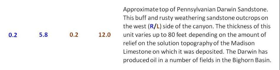
The Amsden formation consists of three members. The uppermost Ranchester Limestone ranges from 100 to 200 feet thick and is and sequence of alternating shallow marine fossiliferous sandy dolomite with interbedded shale units and supratidal cherty dolomite. The supratidal units show signs of exposure with paleosol development. This member grades upward into the Lower Tensleep. The middle Horseshoe Shale Member is 0 to 50 feet of generally slope forming red mudstone and siltstone that is poorly exposed. The Darwin Sandstone Member is brown-grey, fine-grained, cross-bedded sandstone that ranges from 0-80 (?) feet. The Darwin is sporadically located within the canyon on the Madison erosion surface. Where Darwin is absent the middle Horseshoe Shale Member overlies the Madison unconformity.
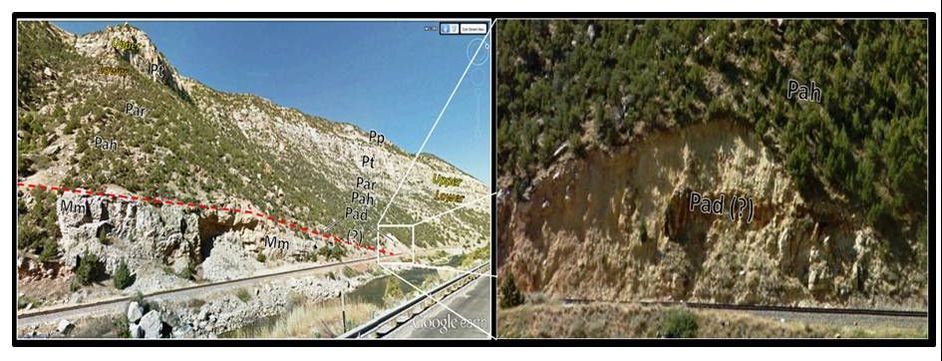
Left: Darwin Sandstone Member of Amsden Formation and Madison Limestone contact shown by white rectangle. Unconformity contact shown by red dashed line. Right: Close-up of Darwin Sandstone at US 20 mile post 125.9. Geologic notation: Pp: Permian Phosphoria Formation, Pt: Pennsylvanian Tensleep Formation, Par: Ranchester Member of Pennsylvanian Amsden Formation, Pah: Horseshoe Shale Member of Pennsylvanian Amsden Formation, Pad (?): possible Darwin Sandstone Member of Pennsylvanian Amsden Formation, Mm: Mississippian Madison Formation.
Images: Annotated Google Earth Street View
Images: Annotated Google Earth Street View
Continue Wind River Canyon Road Log at Wind River Canyon Part Two

The material on this page is copyrighted