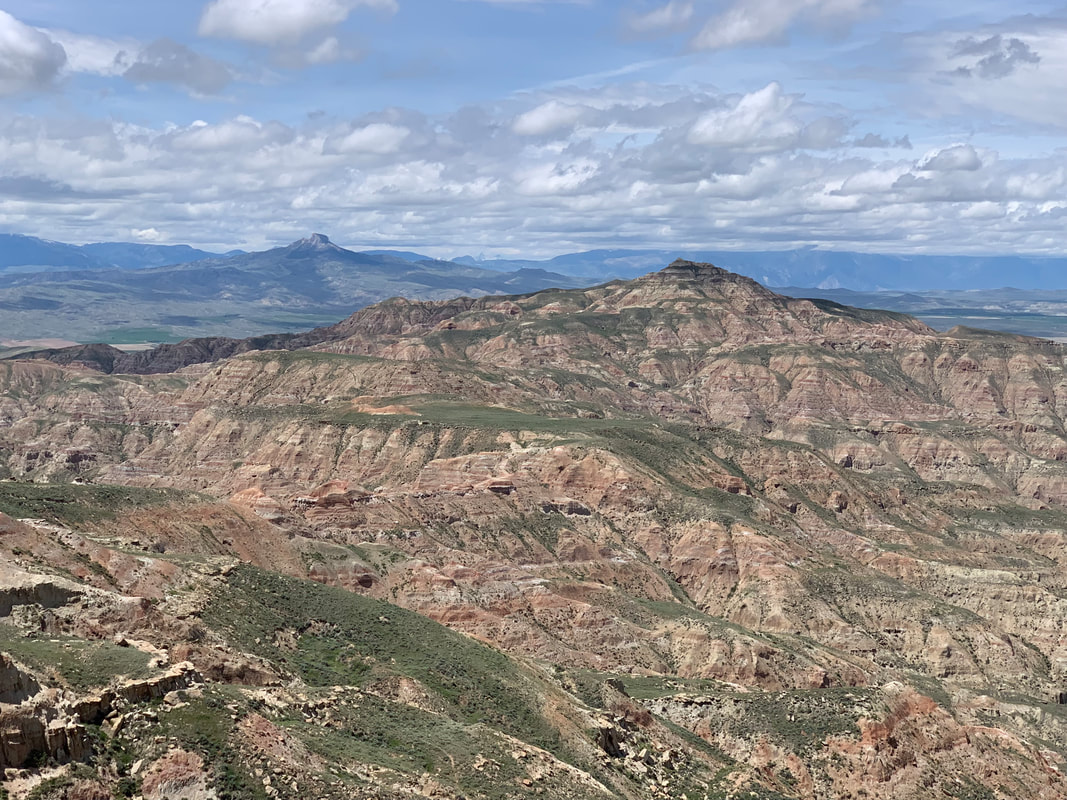
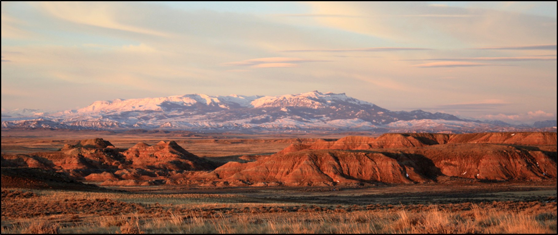
Northwest view of McCullough Peaks with Heart Mountain on left central horizon.
Image Mark Fisher, June 2019
Image Mark Fisher, June 2019
Wow Factor (2 out of 5 stars):
Geologist Factor (2 out of 5 stars):
Attraction
Isolated, wild badlands, sculpted from colorful basin sediments and populated by pronghorn, mule deer and wild horses. Panoramic views of the Bighorn Basin and surrounding mountains from the summit. Peaks strewn with carbonates from the Heart Mountain Detachment. Wilderness Study Area lightly touched by humans.
“To the northeast was a naked range of badland mountains, nude of all timber or other vegetation. They were sharp, jagged, rocky, buckskin-colored hills, with deep crevices. These badland mountains were the McCullough Peaks.”
(Rollinson, J.K., 1941, Pony Trails in Wyoming: Hoofprints of a Cowboy and U.S. Ranger, Bison Book printing, 1988, p. 241)
(Rollinson, J.K., 1941, Pony Trails in Wyoming: Hoofprints of a Cowboy and U.S. Ranger, Bison Book printing, 1988, p. 241)
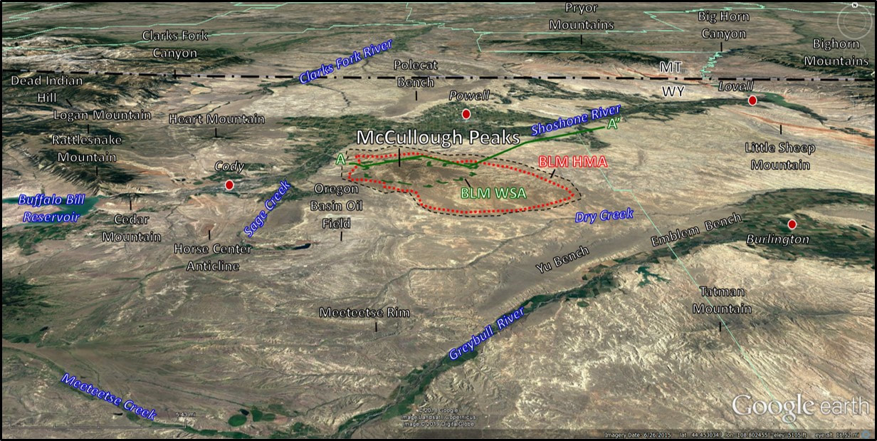
North aerial view of the McCullough Peaks area. The approximate BLM Wilderness Study Area (WSA, dashed green line), cross section AA’ (solid green line), and Horse Management Area (HMA, red dotted line) lie within the McCullough Peaks area (black dashed line) locations are shown.
Image: Google Earth
Image: Google Earth
In the center of the Bighorn Basin, between the Shoshone and Greybull Rivers, stand the McCullough Peaks. The Peaks, rising 1,700 feet above the Shoshone River valley, are an erosional remnant of Tertiary basin fill sediments encompassing about 110,000 acres. The Sevier and Laramide Orogenies elevated the surrounding mountains, sourcing sediments during the Early Tertiary that washed into the rivers and floodplains and filled the Bighorn Basin. Erosion has been the dominant geologic process in the Bighorn Basin over the last five million years, carving the surface and sending these soft sediments to the Gulf of Mexico.
The peaks were named after Peter McCulloch, the foreman of the Carter Ranch in the late 1800’s. Jim Carter began one of the first cattle ranches in the Bighorn Basin along the South Fork of the Shoshone River in 1879. The U.S. Geological Survey changed the name with a spelling error when the topographic map of the area was published, replacing the “och” in the surname with “ough.”
The arid badlands of the peaks discouraged occupation by humans (they preferred settlements near river valleys and creeks). This allowed the peaks to maintain their pristine character and wildlife. The McCullough Peaks are home to 70-140 wild horses. The horses have been feral for centuries believed to have been released or escape from Spanish conquistadors in the 16th century. Over the years additional descendants came from stock escaping from early settlers, Indians, and the U. S. Calvary. Buffalo Bill reportedly let his Wild West Show herd loose in the McCullough Peaks when not touring (1883-1906). DNA analysis established a connection with one of the Queen of England’s stock that was a gift to Cody.
The Bridger Trail (see pending link) crosses to the east of the Peaks. The rugged topography of the area and the seeming lack of water led Bridger to stay on the east flank of the peaks, then veer eastward to Sage Creek near Lovell. The Bridger route was established to provide a safer route to the Montana gold fields than the Indian attack plagued Bozeman Trail in the Powder River Basin. It was used during the 1864 season and provided 25 percent of the Virginia City total population that year. In the 1880’s and 1890’s it was a major freight road between train terminals in Casper and Billings. Local ranchers and homesteaders used the road to connect with markets and for resupply. It was also used as a stage and mail route before motorized roadways were available.
The Bureau of Land Management maintains approximately 110,000 acres in the Peaks as a Horse Management Area (HMA). The 1971 Wild Free-Roaming Horse and Burro Act recognized the benefits of these animals to vegetation.Because they possess upper and lower incisors, horses merely clip the grass as they graze. The organics survive passage through horse’s digestive track (post-gastric system) so their waste reseeds and fertilizes the land. Cattle, not having these upper teeth, pull grass up by the roots with their tongues. Cattle droppings have less organic matter preserved due to their pre-gastric digestive system. In 1884, at the height of the Wyoming cattle business, the U.S. western herd numbered 40 million cattle. Wyoming open range held about 500,000 of those cattle. The western wild horse population numbers about 8,200, and the maximum McCullough Peaks herd is around 100-150 horses. The herds’ population is managed by birth control and bait trapping removal of excess horses.
The McCullough Peaks Wilderness Study Area (WSA) encompasses 24,570 acres along the north flank of the Peaks. It was established in 1984 to protect the north slope badlands from development. The acreage includes BLM-administered and state-owned lands.
Geology of McCullough Peaks
The McCullough Peaks are composed of clastic sediments shed from the surrounding mountains into the subsiding Bighorn Basin. The bulk of the exposed strata belong to the Eocene Willwood Formation. The lithology consists of multicolored clay, sandstone and shale beds. Some thin coal lenses are present in carbonaceous shales. The sediments are eroded into a badlands topography. The maximum thickness of the unit is about 3,200 feet, with an average thickness of 2,500 feet. It overlies the Paleocene Fort Union Formation and together these rocks record one of the most complete Early Tertiary (Paleogene) depositional sequences in the United States. The sedimentary, paleontological and palynological record preserves distinct faunal and floral changes, and also records a large temperature spike (global warming) called the Paleocene-Eocene Thermal Maximum (PETM).
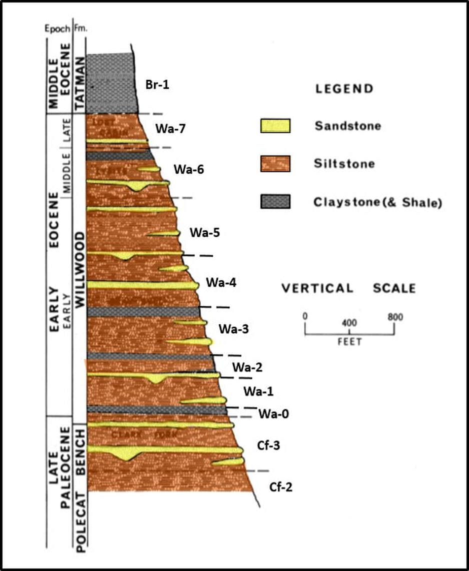
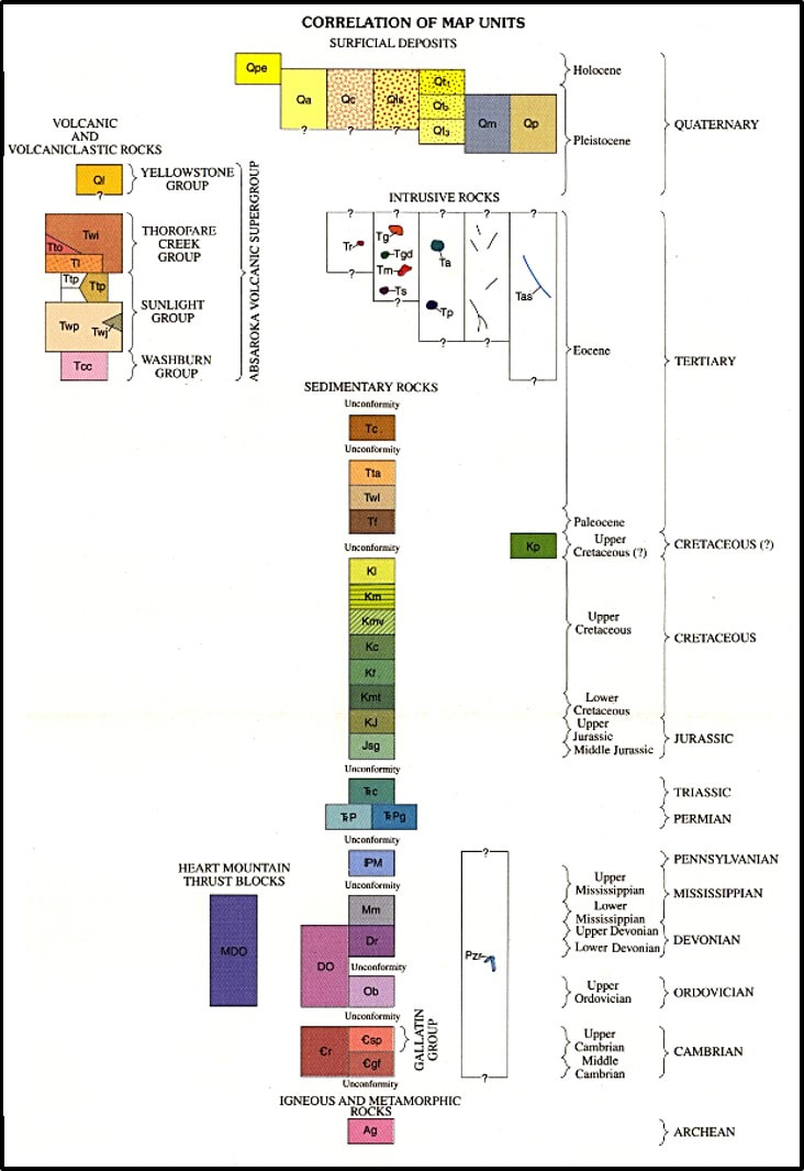
Composite Willwood Formation stratigraphic column from North Sheep Mountain area (Sections 3,4,5,6, & 9, Township 50N, Range 96 West; and Section 11, Township 50N, Range 97 West. Approximate biostratigraphic zones labelled to the right of the lithology. Position of the Paleocene Eocene Thermal Maximum (PETM) is shown as Wa-0.
Image: After Neasham, J.W., 1967, The stratigraphy of the Willwood Formation in the vicinity of Sheep Mountain, southwestern Big Horn County, Wyoming: M.S. Thesis, Iowa State University, Fig. 3, p. 23; https://lib.dr.iastate.edu/cgi/viewcontent.cgi?article=17986&context=rtd
Image: After Neasham, J.W., 1967, The stratigraphy of the Willwood Formation in the vicinity of Sheep Mountain, southwestern Big Horn County, Wyoming: M.S. Thesis, Iowa State University, Fig. 3, p. 23; https://lib.dr.iastate.edu/cgi/viewcontent.cgi?article=17986&context=rtd
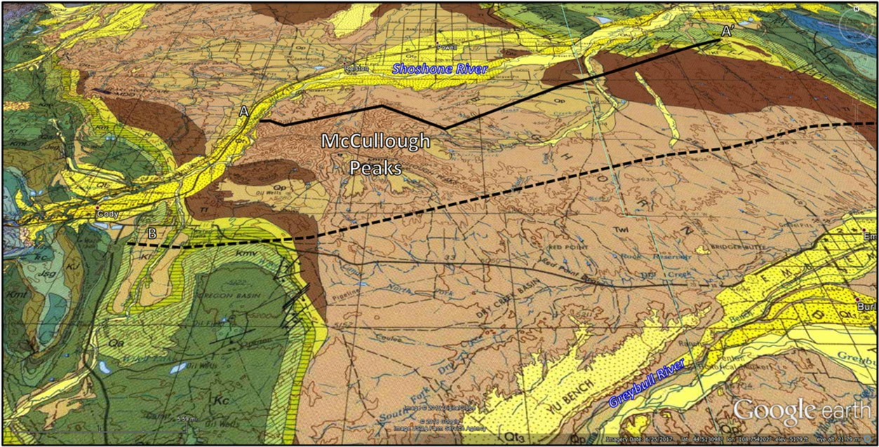
McCullough Peaks area geologic map and formation index. The Willwood Formation (tan) and Fort Union (brown) cover the central portion of the Bighorn Basin. Location of structural cross section AA” and seismic line B are shown
Image: After Pierce, W.G., 1997, Geologic map of the Cody 1 degree X 2 degree quadrangle, northwestern Wyoming: U.S. Geological Survey I-2500, scale 1:250,000; https://ngmdb.usgs.gov/Prodesc/proddesc_13047.htm.
Image: After Pierce, W.G., 1997, Geologic map of the Cody 1 degree X 2 degree quadrangle, northwestern Wyoming: U.S. Geological Survey I-2500, scale 1:250,000; https://ngmdb.usgs.gov/Prodesc/proddesc_13047.htm.
McCullough Peaks structural cross section AA’ with oil and gas wells for subsurface control. The Eocene Willwood Formation (tan) is essentially horizontal beds overlying slightly dipping Paleocene Fort Union Formation (brown).
Image: AfterHadley, D.G., Ryder, R., Hill, R.H., Kulik, D.M., McLeod, K.E., and Jeske, R.E., 1990, Mineral Resources of the McCullough Peaks Wilderness Study Area, Park County, Wyoming: U.S. Geological Survey Bulletin 1756, Fig. 8, p. F16; https://pubs.usgs.gov/bul/1756f/report.pdf.
Image: AfterHadley, D.G., Ryder, R., Hill, R.H., Kulik, D.M., McLeod, K.E., and Jeske, R.E., 1990, Mineral Resources of the McCullough Peaks Wilderness Study Area, Park County, Wyoming: U.S. Geological Survey Bulletin 1756, Fig. 8, p. F16; https://pubs.usgs.gov/bul/1756f/report.pdf.
West to east seismic line B across the McCullough Peaks area, Bighorn Basin. Abbreviations (youngest to oldest age): Twi, Eocene Willwood Formation; Tf, Paleocene Fort Union Formation; Kl, Cretaceous Lance Formation; Km, Cretaceous Meeteetse Formation; Kmv, Cretaceous Mesaverde Formation; Kc, Cretaceous Cody Formation; Kf, Cretaceous Frontier Formation; Kmt-Kcv, Cretaceous Mowry, Thermopolis, Muddy, and Cloverly Formations; J-Tr, Jurassic and Triassic rocks; Pz, Paleozoic rocks; pC, Precambrian rocks.
Image: After Taylor, D.J., 1998, Processing and Interpretation of 2-D Seismic Data from the Bighorn Basin, Wyoming: Wyoming Geological Association 48thAnnual Field Conference, Cretaceous and Lower Tertiary Rocks of the Bighorn Basin, Wyoming and Montana, Plate X, rear map file.
Image: After Taylor, D.J., 1998, Processing and Interpretation of 2-D Seismic Data from the Bighorn Basin, Wyoming: Wyoming Geological Association 48thAnnual Field Conference, Cretaceous and Lower Tertiary Rocks of the Bighorn Basin, Wyoming and Montana, Plate X, rear map file.
The Paleocene Fort Union Formation (Tf, brown unit on the geologic map and cross section) is sourced from highlands elevated during the Sevier Orogeny. Outcrops exhibit a drab gray color of fine clastic sediments. The uppermost beds increase in grain size indicates clasts derived from Laramide uplifts. The lower Eocene Willwood Formation was deposited in a similar alluvial system but is marked by cyclic paleo-soil horizons (paleosols) that indicate a distinct change of climate at the epoch boundary. This event recognized by flora, fauna and carbon oxygen isotope measurement data is known as the PETM.
The Eocene Willwood Formation cyclic paleosol units occur in dark, drab units and lighter, red to purple bands that are interbedded with sheet sands and channels. The dominant Willwood lithology consists of overbank siltstones and mudstones (see stratigraphic column above). The McCullough Peaks Willwood Formation lies across the structural axis of the Bighorn Basin. Structural dips show a nearly flat, gently dipping surface. Steep dips at the western edge of the peaks are due to the Oregon Basin reverse fault.
Paleocene and Eocene streams originated in the western and northwestern highlands and flowed east and south into the Bighorn basin. The Eocene “Idaho River” drained the Challis volcanic field and the Idaho Batholith region of central Idaho. It is the source of Green River Formation deposits in Lake Gosiute. The Owl Creek Mountains on the south end of the Bighorn Basin were buried by sediment by Eocene time, allowing the rivers to flow across them into the Wind River basin to join with the eastward flowing ancestral Wind River (see reconstructed paleo-drainage figure below).
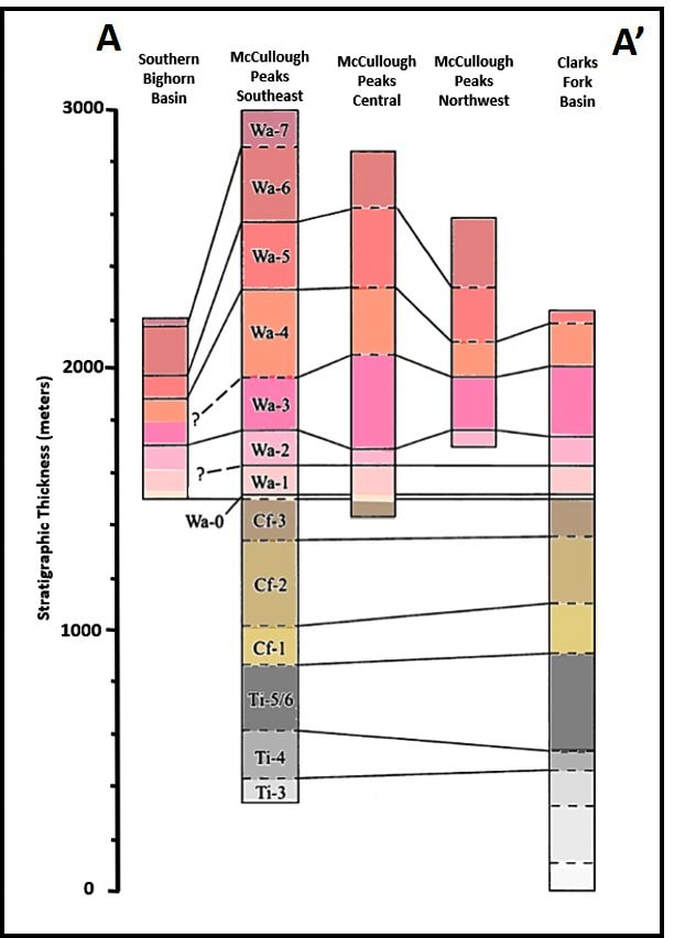
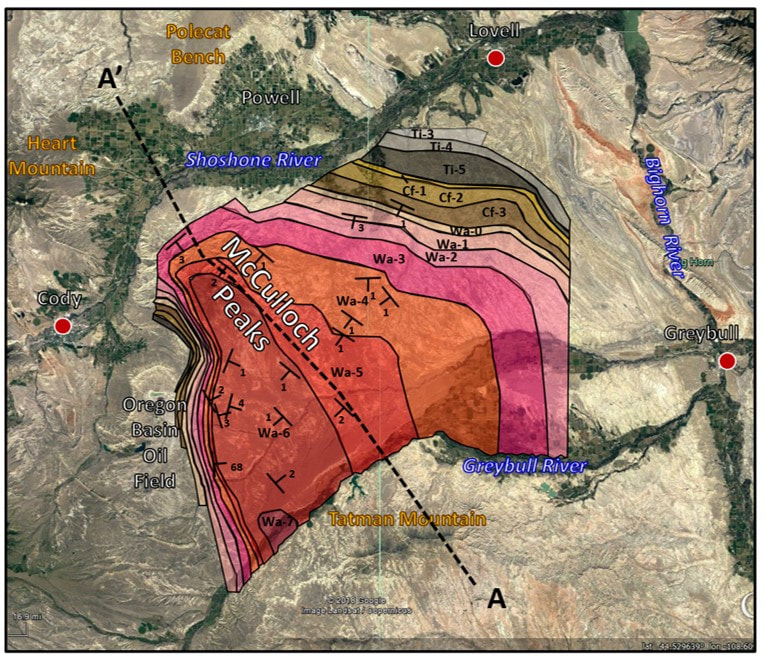
Fence diagram showing thicknesses of biostratigraphic zones in the McCullough Peaks area. Position of the Paleocene Eocene Thermal Maximum (PETM) is Wa-0. Relationship of biostratigraphic zones to formations is shown in Willwood stratigraphic column above geologic map.
Image: After Clyde, W.C., 2001, Mammalian Biostratigraphy of the McCullough Peaks Area in the Northern Bighorn Basin: in Paleocene-Eocene Stratigraphy and Biotic Change in the Bighorn and Clarks Fork Basins, Wyoming (P. D. Gingerich, ed.), University of Michigan Papers on Paleontology, 33, Fig. 10, p. 123;
Image: After Clyde, W.C., 2001, Mammalian Biostratigraphy of the McCullough Peaks Area in the Northern Bighorn Basin: in Paleocene-Eocene Stratigraphy and Biotic Change in the Bighorn and Clarks Fork Basins, Wyoming (P. D. Gingerich, ed.), University of Michigan Papers on Paleontology, 33, Fig. 10, p. 123;
Biostratigraphic Zone boundaries in the McCullough Peaks area. Structural dip shown by “T’s” with dip value posted. Approximate location of fence diagram AA’ is shown by black dashed line.
Image: After Clyde, W.C., 1997, Stratigraphy and Mammalian Paleontology of the McCullough Peaks, Northern Bighorn Basin, Wyoming: Implications for Biochronology, Basin Development, and Community Reorganization across the Paleocene-Eocene Boundary: PhD Dissertation, University of Michigan;
https://www.researchgate.net/profile/William_Clyde/publication/35928853_Stratigraphy_and_mammalian_paleontology_of_the_McCullough_Peaks_Northern_Bighorn_Basin_Wyoming_implications_for_biochronology_basin_development_and_community_reorganization_across_the_Paleocene-Eocene/links/54eb8fa20cf2082851be230c/Stratigraphy-and-mammalian-paleontology-of-the-McCullough-Peaks-Northern-Bighorn-Basin-Wyoming-implications-for-biochronology-basin-development-and-community-reorganization-across-the-Paleocene-Eo.pdf?origin=publication_detail.
Paleo-drainage reconstruction from Paleocene to Eocene in the central Rocky Mountains. Blue arrows represent the interpretation of Paleocene paleo-drainage (~60 Ma) based on Fort Union detrital zircon ages. Green arrows represent Willwood paleo-drainage at ~53 Ma. Red arrows indicate their interpretation of the Eocene Idaho River which headed in central Idaho before discharging in Lake Gosiute in the Green River basin at about 50 Ma.
Image: After Leonard, A., Malone, D., and Craddock, J.P., 2013, Provenance Analysis of the Fort Union Formation in the Western Big Horn Basin Using U-PB Detrital Zircon Geochronology: Geological Society of America Conference Paper Poster, Fig. 5; https://www.researchgate.net/publication/308948866_PROVENANCE_ANALYSIS_OF_THE_FORT_UNION_FORMATION_IN_THE_WESTERN_BIG_HORN_BASIN_USING_U-PB_DETRITAL_ZIRCON_GEOCHRONOLOGY.
Image: After Leonard, A., Malone, D., and Craddock, J.P., 2013, Provenance Analysis of the Fort Union Formation in the Western Big Horn Basin Using U-PB Detrital Zircon Geochronology: Geological Society of America Conference Paper Poster, Fig. 5; https://www.researchgate.net/publication/308948866_PROVENANCE_ANALYSIS_OF_THE_FORT_UNION_FORMATION_IN_THE_WESTERN_BIG_HORN_BASIN_USING_U-PB_DETRITAL_ZIRCON_GEOCHRONOLOGY.
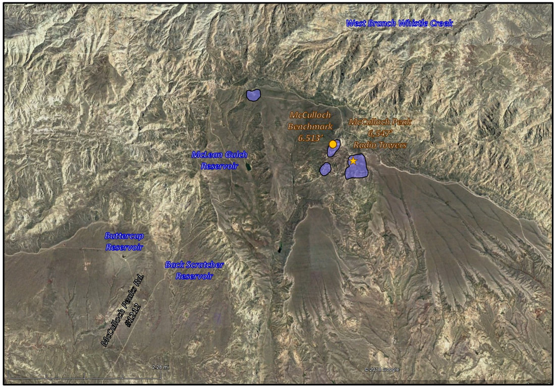
Along the western edge of the peaks, at elevations that approximate the Eocene basin floor, are perched blocks of Paleozoic carbonate. These are remnants from the Heart Mountain detachment which occurred about 49 million years ago. These blocks were once thought to be the most distant point from the detachment (55 miles), until the discovery at Squaw Buttes which is about 80 miles from the Heart Mountain detachment.
Heart Mountain Detachment blocks (blue) on the McCullough Peaks.
Image: Google Earth
Image: Google Earth
The McCullough Peaks are a spectacular badlands region. Mountain cliffs and canyons with colorful rock formations paint the landscape. The rocks hold important paleoclimatic and paleontological data to interpret Early Paleogene climate and mammalian evolution. It is also a place where wild horses run free, and “the deer and antelope play.”
McCullough Peaks badlands with Carter Mountain in background.
Image: https://www.blm.gov/sites/blm.gov/files/WY_McCulloughPeaksWSA1.png?timestamp=1499452744.
Image: https://www.blm.gov/sites/blm.gov/files/WY_McCulloughPeaksWSA1.png?timestamp=1499452744.
Things To Do at McCullough Peaks
We think you will be surprised that exploring and hiking in the McCullough Peaks makes for a very pleasant day. The prettiest time to visit is in May or June when it is green and the flowers are blooming. A high clearance vehicle would be helpful for the occasional ruts, but 4WD was not necessary on the main roads we visited. Don’t go if the roads are wet. You are on your own in these areas with minimal to no traffic. That is part of the attraction, so come prepared.
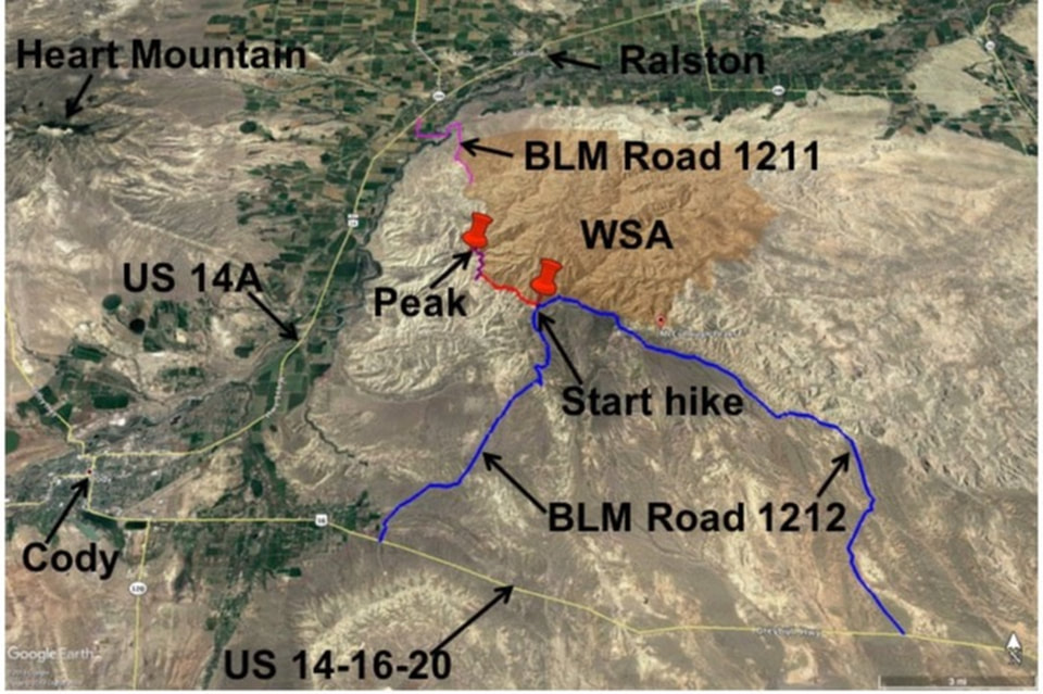
Map of main access roads to McCullough Peaks area.
Image by Google Earth
Image by Google Earth
Directions to McCullough Peaks from the south
From Cody to McCullough Peaks is a 15 mile drive that takes about 30 minutes each way (see map above). If you have the time, you can make it a loop drive of 47 total miles and 1-1/2 hours. Directions: Starting in downtown Cody at the intersection of US 14-16-20 (Sheridan Ave) and US 14A (16th St), head east toward Greybull on US 14-16-20, 0.5 miles intersection Stampede Ave continue straight, 2.2 miles Wyo 120 intersection continue straight, 7.2 miles turn left (north) on unpaved BLM 1212 McCullough Peak Road, which is immediately opposite the Cody Archery Range, 10.8 miles Y intersection take right fork, 12.5 miles pass through gate on steep hill, 13.9 miles pass through gate with radio towers in distance, 15.3 miles pass abandoned fence line, 15.4 miles Wilderness Study Area boundary (WSA) markers on left, park for hikea couple hundred feet before the turn where the dirt two-track takes off to left. After hike return the same way to Cody or take loop drive back to Cody. Loop directions:15.4 miles continue on same road, 15.6 miles outcrops on right and WSA on left, 15.7 pass through gate, WSA on left, 16.2 miles ponds on both sides of road, 16.9 miles go straight at junction with road to private radio towers, 17.5 miles cattle guard, 18.4 miles more radio towers on right, 20.9 miles cattle guard, 22.3 miles outcrops of Willwood on left, 23.4 miles badlands with drop off on left, flats to right, 28.8 miles turn right (east) at junction with US 14-16-20 to return to Cody, 39.6 miles continue straight at intersection with BLM 1212, 47 miles at starting intersection in downtown Cody.
Hike the McCullough Peaks WSA boundary & climb one of the Peaks
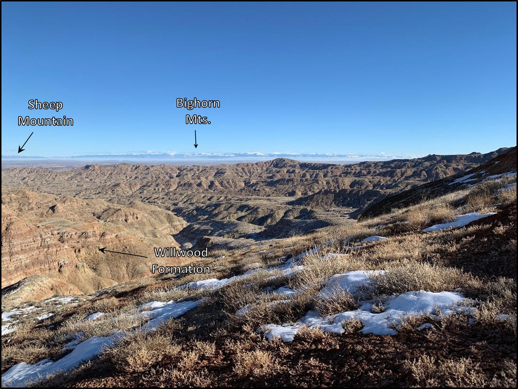
Northeast view of the McCullough Peaks Wilderness Study Area from hike along boundary. Prominent candy-stripping bands of the Willwood Formation displayed left of center. The snow-capped, cloud topped Bighorn Mountains are on the horizon with Sheep Mountain Anticline to the left of the Bighorn Canyon gap in the photograph.
Image: Mark Fisher, January 2019
Image: Mark Fisher, January 2019
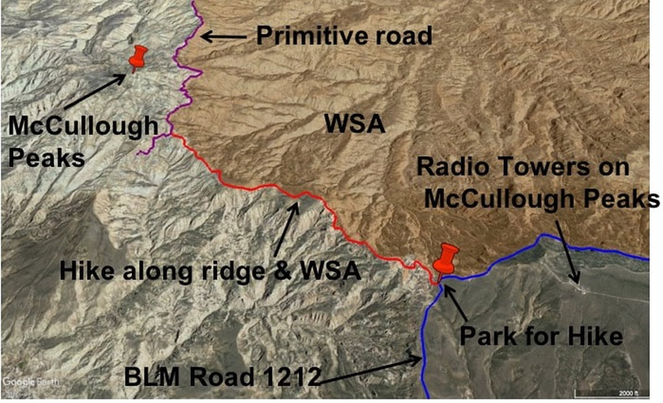
The hike (see map below) mostly follows the remains of a primitive dirt road along a northwest trending ridge toward one of the McCullough Peaks. The ridge forms the southwest border of the McCullough Peaks Wilderness Study Area (WSA) and there are great views into these badlands. We would characterize the difficulty of the first two miles of trail as easy to moderate. There are no trail markers or much of a path at the very beginning. You can look to the northwest from the BLM 1212 road and see the trail on the ridge. Walk down the steep hill and intersect this trail. Note the scattered white to gray carbonate rocks on the ground near the road that are the remains of the Heart Mountain Detachment. The trail along this ridge descends about 400 vertical feet over the first ¾ mile. It then rises and falls a couple hundred vertical feet until you reach a saddle at about two miles. At the saddle, the trail merges/terminates with the remains of a primitive dirt road coming in from the south (left) that continues to the north (right). As this road goes north, it marks the west boundary of the WSA. At this point you can turn around and go back to the vehicle, or go further on the intersected road, or climb the McCullough Peak immediately in front of you to the northwest. The peak is slightly over a 500 foot vertical climb from the saddle and is a scramble with no trail. You must decide if this is safe. If you climb the peak (6,442 foot elevation), total round trip from the vehicle is 5.2 miles that takes about four hours with 1,600 feet descent and 1,600 feet ascent. A look on Google Earth before hiking will help orient you.
Map of hike along McCullough Peaks Wilderness Study Area boundary
Image by Google Earth
Image by Google Earth
Directions to northwest corner of McCullough Peaks Wilderness Study Area
From Cody to the northwest corner of the McCullough Peaks Wilderness Study Area is a 17 mile drive that takes less than 30 minutes each way (see map above). Directions: Starting in downtown Cody at the intersection of US 14-16-20 (Sheridan Ave) and US 14A (16th St), head northeast toward Powell on US 14A, 13.2 miles pass intersection with Park County Road 19 to Heart Mountain Relocation Center & Heart Mountain, 14.2 miles turn right (south) on Park County Road 18, 14.8 miles turn left (east) on Park County Lane 15, 15.6 miles cross Shoshone River on bridge adjacent to Willwood Dam, 16.2 miles turn right (south) on unpaved BLM 1211 Willwood Dam Road, 16.3 miles Y intersection take right fork, 16.8 miles cattle guard and BLM information kiosk, 17 miles reach northwest boundary of WSA. The roads beyond this point are more appropriate for ATVs. From here you can take a road east along north edge of WSA near the power lines or drive south on roads along west edge of the WSA.

The material on this page is copyrighted
