
North view of Big Cedar Ridge Image by Mark Fisher
Wow Factor (2 out of 5 stars):

Geologist Factor (3 out of 5 stars):

Attraction
Subtropical plants buried by a volcanic ash fall creating a"Botanical Pompeii”. For a rockhound, fossil plant material generates a reaction similar to gold fever.
Geology of Big Cedar Ridge
Seventy three million years ago the sun rose on a coastal plain and delta with a lush subtropical flora of ferns, palmettos and broadleaf flowering plants. At some point the skies darkened, and fine volcanic ash began to fall from the sky. Then the rain came. Water mixed the ash into a mud slurry that entombed thickets and wetlands in a mudflow, capturing an instant in geological time. This ancient landscape is preserved in the Late Cretaceous Meeteetse Formation along 2.5 mile of outcrop at Big Cedar Ridge (BCR) in the Bighorn Basin, about 23 miles southeast of Worland (32 miles by road).
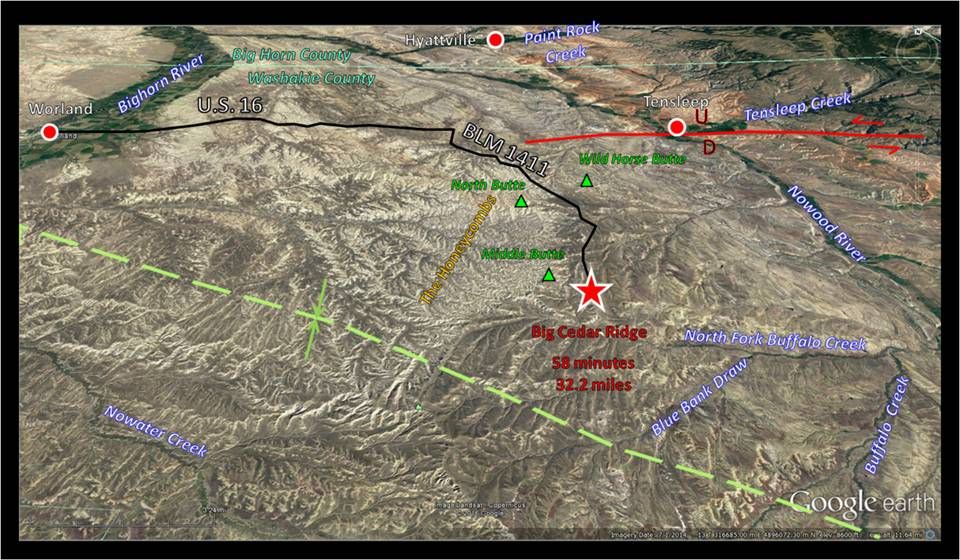
North aerial view of Big Cedar Ridge Area, red star. Thirty two mile route from Worland shown by solid black line. Green dashed line shows position of the Bighorn Basin axis. The Tensleep fault location indicated by solid red line.
Image: Google Earth
Image: Google Earth
The Meeteetse Formation (73-69.4 Ma) overlies the marine deposits of the Campanian (82-73 Ma) Mesaverde Formation and underlies the continental river beds of the Maastrichtian (69.4-65.4 Ma) Lance Formation in the Bighorn Basin. The Meeteetse Formation consists largely of a package of nonmarine and marginal marine siltstones, shales, sandstones and coal beds deposited on a poorly drained coastal plain.
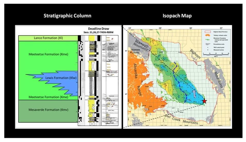
Left and bottom explanation: Late Cretaceous Meeteetse Formation stratigraphic column from Big Cedar Ridge area. Right: Thickness map for the Meeteetse Formation in the Bighorn Basin showing a general thinning trend from west to east; thickness contours are 100 feet. The marine shale of the Lewis Formation is included in the map data. The blue dashed line shows the western limit of the incursion of the Western Interior Seaway. The red star marks the location of Big Cedar Ridge and the Deadline Draw outcrop.
Images: Left and bottom explanation: After Johnson, R.C., Keefer, W. R. Keighin, C. W. and Finn, T. M., 1998, Detailed Outcrop Studies of the Upper Part of the Upper Cretaceous Cody Shale and the Upper Cretaceous Mesaverde, Meeteetse, and Lance Formations, Bighorn Basin, Wyoming: WGS Guidebook, Plate 2. Right: Finn, T.M., Kirschbaum, M.A., Roberts, S.B., Condon, S.M., Roberts, L.N.N. and Johnson, R.C., 2010, Chapter 3: Cretaceous–Tertiary Composite Total Petroleum System (503402), Bighorn Basin, Wyoming and Montana: USGS DDS 69-V, Fig. 15, p. 20; https://pubs.usgs.gov/dds/dds-069/dds-069-v/REPORTS/69_V_CH_3.pdf
Images: Left and bottom explanation: After Johnson, R.C., Keefer, W. R. Keighin, C. W. and Finn, T. M., 1998, Detailed Outcrop Studies of the Upper Part of the Upper Cretaceous Cody Shale and the Upper Cretaceous Mesaverde, Meeteetse, and Lance Formations, Bighorn Basin, Wyoming: WGS Guidebook, Plate 2. Right: Finn, T.M., Kirschbaum, M.A., Roberts, S.B., Condon, S.M., Roberts, L.N.N. and Johnson, R.C., 2010, Chapter 3: Cretaceous–Tertiary Composite Total Petroleum System (503402), Bighorn Basin, Wyoming and Montana: USGS DDS 69-V, Fig. 15, p. 20; https://pubs.usgs.gov/dds/dds-069/dds-069-v/REPORTS/69_V_CH_3.pdf
In the southeast part of the Bighorn Basin, the Meeteetse coastal plain sediments interfinger with the Western Interior Seaway deposits. These marine units are called the Lewis Formation. Volcanoes of the Elkhorn volcanic field were active in south central Montana throughout deposition of the Meeteetse Formation, as evidenced by the high volume of ash and bentonitic clays (weathered ash) it contains. The vast Elkhorn magmatic system buried a 100 mile diameter area in Montana beneath two to three mile thick volcanic deposits. (The system is also responsible for the preservation of hadrosaurian dinosaurs and their nests at Egg Mountain, near Choteau, MT.) Both the Meeteetse and Lewis were deposited in a large basin east of the Sevier Mountain chain, just before the breakup of the area at the start of the Laramide mountain building event.
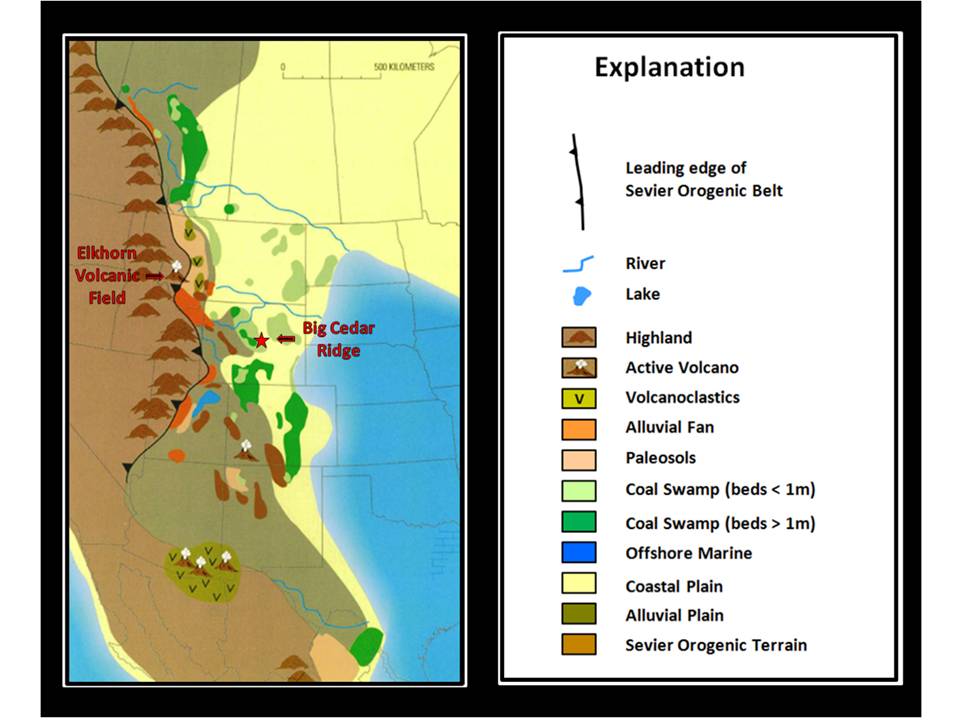
Paleogeographic reconstruction during deposition of ash at Big Cedar Ridge. Red Star shows location of Big Cedar Ridge Area.
Image: After Robinson Roberts, L.M. and Kirschbaum, M.A., 1995, Paleogeography of the Late Cretaceous of the Western Interior of Middle North America; Coal Distribution and, Sediment Accumulation: USGS Professional Paper 1561, Fig. 22, pp. 45-46; https://pubs.usgs.gov/pp/1561/report.pdf
Image: After Robinson Roberts, L.M. and Kirschbaum, M.A., 1995, Paleogeography of the Late Cretaceous of the Western Interior of Middle North America; Coal Distribution and, Sediment Accumulation: USGS Professional Paper 1561, Fig. 22, pp. 45-46; https://pubs.usgs.gov/pp/1561/report.pdf
The Big Cedar Ridge site was discovered by Scott Wing of the Smithsonian Institution in 1990. The exceptional plant fossils are preserved where they grew, so paleobotanists can map the distribution of vegetation in the ancient ecosystem. Even the ancient soil was preserved under the ash layer, with the plant roots extending into it. The Smithsonian has referred to the area as a "Botanical Pompeii." About 175 types of plants have been collected there, including over 100 new plant species. In addition, five types of insect damage were detected in the plant fossils. The lush, subtropical area was probably home to many animals, including crocodiles, snakes, turtles, small mammals, birds and dinosaurs, but their fossils have not been found.
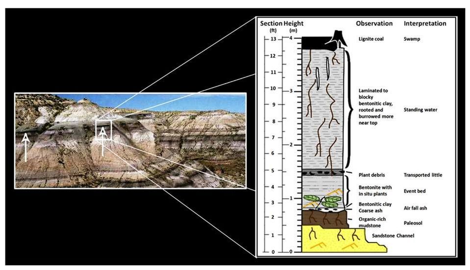
Left: Big Cedar Ridge outcrop of a portion of the Meeteetse Formation. The ash bed occurs in about the middle of the ridge exposure. Arrows point to paleosol horizon below event bed. Bottom of arrows are on prograding delta foreset cross beds. White rectangle is area of generalized section of Big Cedar Ridge ash deposit and associated beds.
Right: Generalized stratigraphic column of ash deposit. The ash bed age has been reported at 72.7 + 1.34 million years before present.
Images: Left: After Wing, S.L., Stromberg, C.A.E., Hickey, L.J., Tiver, F., Willis, B., Burnham, R.J., and Behrensmeyer, A.K., 2012, Floral and environmental gradients on a Late Cretaceous landscape: Ecological Monographs, Vol. 82, No. 1, Fig. 1B, p. 25. https://www.researchgate.net/profile/Scott_Wing/publication/236687451_Floral_and_environmental_gradients_on_a_Late_Cretaceous_landscape/links/00b7d51917b63a6d2a000000/Floral-and-environmental-gradients-on-a-Late-Cretaceous-landscape.pdf
Right: After Wing, S.L., Stromberg, C.A.E., Hickey, L.J., Tiver, F., Willis, B., Burnham, R.J., and Behrensmeyer, A.K., 2012, Floral and environmental gradients on a Late Cretaceous landscape: Ecological Monographs, Vol. 82, No. 1, Fig. 2, p. 26. https://www.researchgate.net/profile/Scott_Wing/publication/236687451_Floral_and_environmental_gradients_on_a_Late_Cretaceous_landscape/links/00b7d51917b63a6d2a000000/Floral-and-environmental-gradients-on-a-Late-Cretaceous-landscape.pdf
The earliest definitive fossils of angiosperms (flowering plants) are about 130 million years old (Early Cretaceous). Tiny fossils of pollen and possible flowers suggest they may have evolved tens of millions of years earlier. The plant community at BCR lived when angiosperms were diversifying and starting to spread to new niches. However, the BCR landscape was still dominated by gymnosperms including ferns and conifers. Gymnosperm plants reproduce with spores and unprotected seeds, and receive wind-blown pollination. They need to live close enough together for the pollen to drift to nearby plants. Flowering plants are pollinated by insects and other animals. Today, angiosperms comprise about 70 percent of Earth's vegetation with about 250,000 species. Gymnosperms have about 15,000 remaining species.
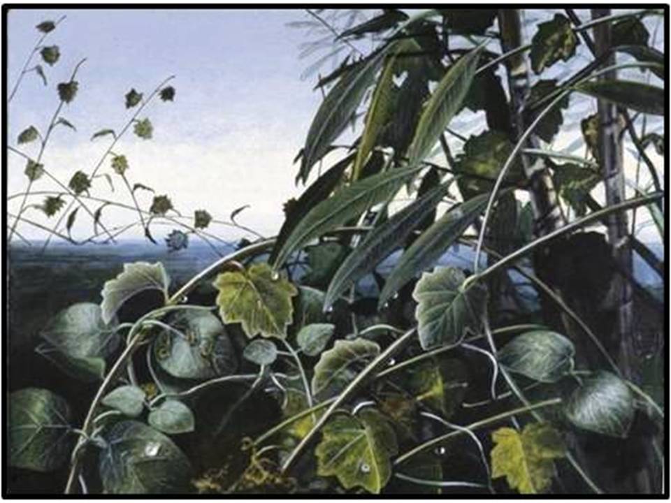
Detailed mapping of the BCR plant fossils allowed paleobotanists to reconstruct three different vegetation communities at Big Cedar Ridge: Fern Wetlands on organic rich soil, Palmetto Thickets on moderately organic rich soil and Streamside Thickets on the coarser soil. The mapping showed that the broad leafed flowering plants, including a relative of modern buttercups, lived along the banks of streams on well-lit, coarser soils that were disturbed by the migration of the meandering streams.
Detailed mapping of the BCR plant fossils allowed paleobotanists to reconstruct three different vegetation communities at Big Cedar Ridge: Fern Wetlands on organic rich soil, Palmetto Thickets on moderately organic rich soil and Streamside Thickets on the coarser soil. The mapping showed that the broad leafed flowering plants, including a relative of modern buttercups, lived along the banks of streams on well-lit, coarser soils that were disturbed by the migration of the meandering streams.
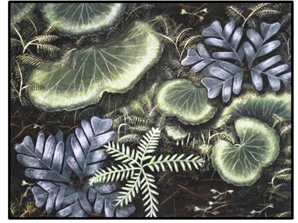
Fern Wetland
Streamside Thicket
Palmetto Thicket
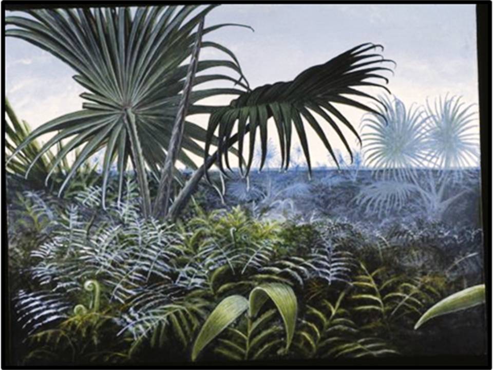
Reconstructions of the three main vegetation types at Big Cedar Ridge.
Images: Reconstructions by Mary Parrish, 2010;
After https://naturalhistory.si.edu/Ete/ETE_People_Wing_ResearchThemes_BCR.html
Images: Reconstructions by Mary Parrish, 2010;
After https://naturalhistory.si.edu/Ete/ETE_People_Wing_ResearchThemes_BCR.html
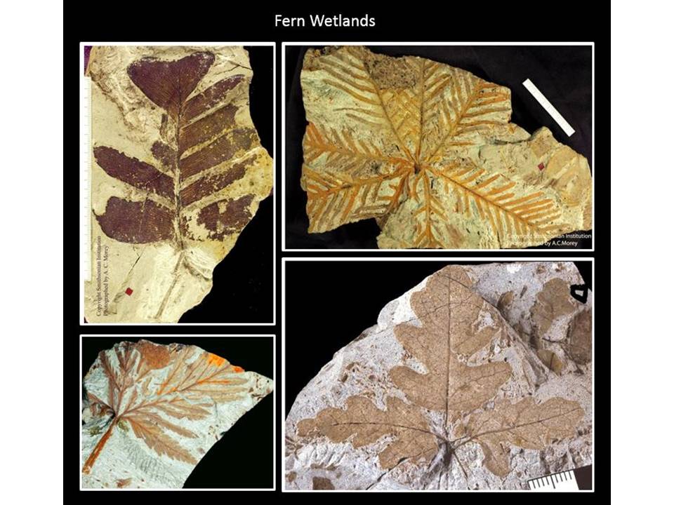
Fern Wetlands plant fossils
Images: Wing, S.L., Stromberg, C.A.E., Hickey, L.J., Tiver, F., Willis, B., Burnham, R.J., and Behrensmeyer, A.K., 2012, Floral and environmental gradients on a Late Cretaceous landscape: Ecological Monographs, Vol. 82, No. Top Left: 1, Fig. 3A, p. 27; Bottom left: Issue cover.
https://naturalhistory.si.edu/ETE/ETE_People_Wing_ResearchThemes_BCR_FernFossils.html
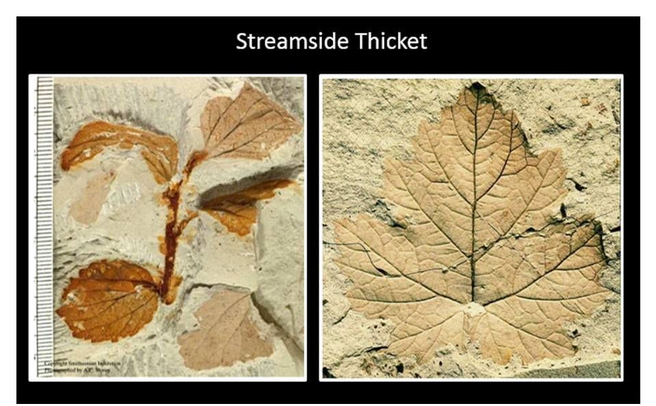
Flowering plants from Streamside Thickets
Image: https://naturalhistory.si.edu/ETE/ETE_People_Wing_ResearchThemes_BCR_StreamsideFossils.html
Image: https://naturalhistory.si.edu/ETE/ETE_People_Wing_ResearchThemes_BCR_StreamsideFossils.html

Familiar palmettos dominated the Palmetto Thickets.
Images: Left: https://naturalhistory.si.edu/ETE/ETE_People_Wing_ResearchThemes_BCR_PalmettoFossils.html
Right: Digging the Fossil Record: Paleobiology at the Smithsonian, 2013, http://nmnh.typepad.com/smithsonian_fossils/2013/07/collections-highlights-botanical-pompeii.html
Images: Left: https://naturalhistory.si.edu/ETE/ETE_People_Wing_ResearchThemes_BCR_PalmettoFossils.html
Right: Digging the Fossil Record: Paleobiology at the Smithsonian, 2013, http://nmnh.typepad.com/smithsonian_fossils/2013/07/collections-highlights-botanical-pompeii.html
The BCR site was discovered on federal land under the jurisdiction of the Bureau of Land Management (BLM). The BLM evaluated the area with input from recreation planners, land managers, Washakie County Commissioners, museums, historical societies, paleontologists, archeologists and the public through site visits, open meetings, correspondence and comments. According to the BLM, "public interest in the area was high and favored protecting the fossil plants." Based on the feedback, the BLM set aside the 260 acres with the highest fossil concentrations to protect them from surface disturbance and mineral extraction. Interpretive signs and a parking lot were added to the site to enhance its accessibility. The site is open to the public for recreation and casual collection of plant fossils, and for continued scientific research. Visitors to this high desert location surrounded by mountain ranges can envision the Late Cretaceous lush semitropical landscape that existed here 73 million years ago, with the distant Sevier Mountains beyond the horizon to the west and the last interior seaway off to the southeast, where the southern Bighorn Mountains now stand
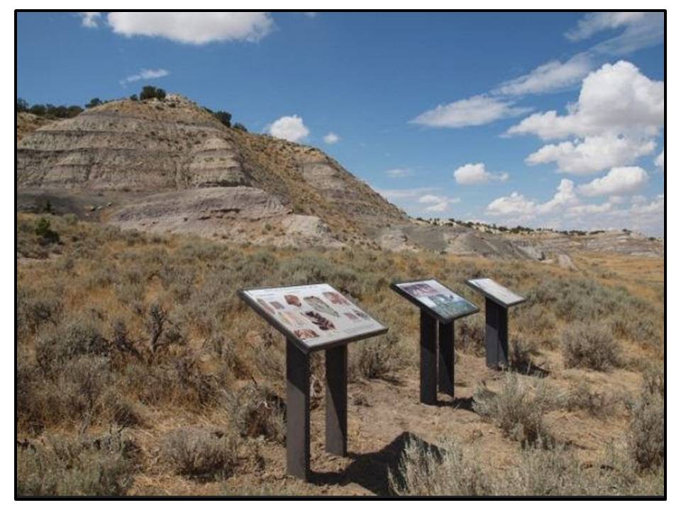
Big Cedar Ridge and BLM interpretive signs.
Image: BLM photo, 2014, https://www.flickr.com/photos/mypubliclands/15143941004/
Image: BLM photo, 2014, https://www.flickr.com/photos/mypubliclands/15143941004/
What You Will See At Big Cedar Ridge
For the average tourist, there is not very much of interest on the drive or even at Big Cedar Ridge. However, this might be your kind of place if you are a rockhound and/or geologist and persevere until you find fossil plants. You will need to bring a shovel and perhaps other tools like a mattock to dig away the weathered shale. It will take some time. The ash zone or bentonite that buried the plants weathers in a popcorn appearance. It is messy when wet and retains water. Along this ash zone only a short distance above the BLM interpretive signs, you will recognize small excavation pits where people have dug looking for fossils.

View of Big Cedar Ridge ash layer from near BLM interpretive signs
Image by Mark Fisher
Image by Mark Fisher
Directions to Big Cedar Ridge
It is a 25 mile drive on mostly dirt road from Tensleep to Big Cedar Ridge that takes around one hour each way. When dry, you will not need 4WD. Good ground clearance on your vehicle is helpful because of ruts and the occasional small washout. This is not a road for your Mustang or Cadillac sedan. Do not drive this road if it is wet. There is minimal to no traffic in this area. You are on your own with no cell coverage. The punchline "It is not the end of the earth, but you can see it from here" applies to this place.
Starting in downtown Tensleep at Dirty Sally’s, head west on US 16 toward Worland, 0.7 miles cross Nowood River, 1.0 miles Tensleep Brewing on right, 1.5 miles Tensleep fault has caused the steeply dipping beds adjacent to the road, 2.1 miles Castle Garden turnoff (See Geowyo Castle Garden page), 9.4 miles turn left on Blue Bank Road (1411) and travel on dirt road, 10.6 miles reach T intersection turn left on Old Tensleep Highway, 11.0 miles turn right on Blue Bank Road (1411), 12.0 miles intersection with W-T Stock Drive, bear right and stay on Blue Bank Road, 15.6 miles road goes down a hill into a valley, 18.4 miles intersection with Two Mile Hill Road (back route to Castle Gardens) continue straight on Blue Bank Road, 19.6 miles intersection with Bud Kimball Road, continue straight on Blue Bank Road, 20.7 miles small building on right with red roof, 22.4 miles cattle corrals on right, 23.9 badlands on right is Big Cedar Ridge, 24.8 miles arrived at BLM interpretive signs at Big Cedar Ridge.
The Cody 59ers Rock Club (Cody, WY) and Shoshone Rock Club (Powell, WY) visited the Big Cedar Ridge site and wrote-up their field trip in the August, 2016 newsletter for the Wyoming State Mineral & Gem Society.
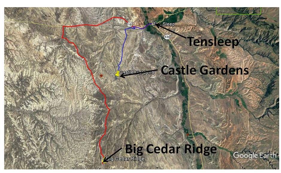
Route from Tensleep to Big Cedar Ridge in red, route from Tensleep to Castle Gardens in blue.
Image: Google Earth
Image: Google Earth

The material on this page is copyrighted