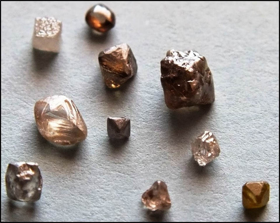
Rough diamonds from Wyoming.
Image: Hausel, W.D., August 4, 2011, Gem Hunter’s Blog post; http://gemwy.blogspot.com/2011/08/wyoming-is-number-one-gemstone-state-in.html
Image: Hausel, W.D., August 4, 2011, Gem Hunter’s Blog post; http://gemwy.blogspot.com/2011/08/wyoming-is-number-one-gemstone-state-in.html
Wow Factor (3 out of 5 stars):

Geologist Factor (2 out of 5 stars):

History of Diamonds
Legends speak of the diamond’s influence on health, knowledge, and love. Legendary mountain man Jim Bridger told tall tales of petrified sage brush that “… bore diamonds, rubies, sapphires and emeralds as large as walnuts” and of a mountain with a diamond that shone sufficient light to travel at night (Alter, 1962, p. 287). The discovery of diamonds during hydraulic mining for placer gold in California prompted one geologist to write, “… though it may not pay to hunt for diamonds, yet it always pays to pick them up when you do happen to see them.” Superman could make a diamond from a lump of coal, a trick he seemed to do his whole life.
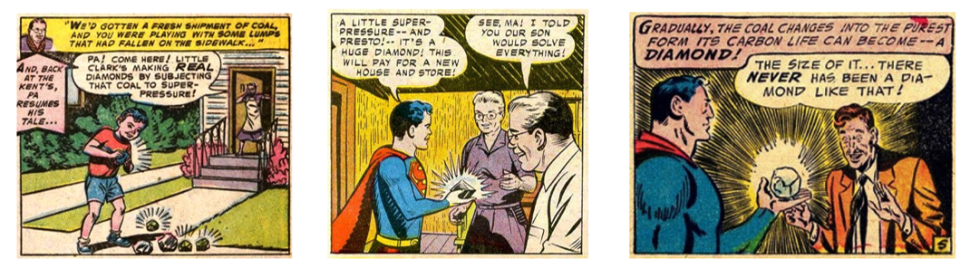
The “Man-of-Steel” promoted the coal myth as Supertot, Superboy and Superman. Diamonds are made of pure carbon and the purity of coal is inadequate to make a diamond. Superman would have better luck with a lump of graphite if his super-squeeze could produce 150,000 times earth’s atmospheric pressure (Manuel Gnida, 2014, SLAC National Accelerator Laboratory).
Images: Left and Center.http://sacomics.blogspot.com/2011/05/diamond-jim.html
Right: https://authormarycsimmons.files.wordpress.com/2013/09/sizeofit.jpg?w=300&h=226
Images: Left and Center.http://sacomics.blogspot.com/2011/05/diamond-jim.html
Right: https://authormarycsimmons.files.wordpress.com/2013/09/sizeofit.jpg?w=300&h=226
But until 1869 all the world’s known diamonds came from alluvial placer deposits eroded from some unknown source rock. The first diamonds were discovered over 2,500 years ago. They came from the “valley of diamonds” of the Krishna River, India. India was the only source until similar placer deposits were discovered in Brazil in 1726. The first South African diamonds, also placer, were found in 1866.
The supply of the precious stones increased with the discovery near Kimberley, South Africa in 1869. These stones were far from any river and occurred in a weathered host rock called “yellow ground.” Yellow ground was recognized as an oxidized igneous rock. The host rock was named kimberlite after the nearby town. It was here that Cecil Rhodes began his De Beers Consolidated Mines venture in 1888.
Most miners believed that diamond deposits ended at the base of the “yellow ground.” Rhodes believed that the harder blue-tinted rock beneath could hold diamonds. With the financial panic of 1873, he purchased unwanted claims of this so called “blue ground.” The color was due to a weathered montmorillonitic clay zone above the hard kimberlite rock.
The etymology of diamond is from the Greek word “adámas,” meaning unconquerable, invincible, or unbreakable. These same adjectives could be used to describe the scheme that came to be known as “The Great Diamond Hoax of 1872.”
Wyoming Diamond Field Fraud
Cousins Philip Arnold and John Slack devised a salting scheme just south of the Wyoming state line that attracted rich investors. Diamond fever was rampant with the discoveries in South Africa. Their bait, a bag of precious stone cut waste from London, was purchased for $37,000 and deposited in a San Francisco bank. They said the stones were discovered in a secret location. Greed would eventually snare investment from three Civil War Generals, the founder and editor of the New-York Tribune, the Rothschild’s banking house, at least a dozen San Francisco and New York financiers and the founder of Tiffany’s.
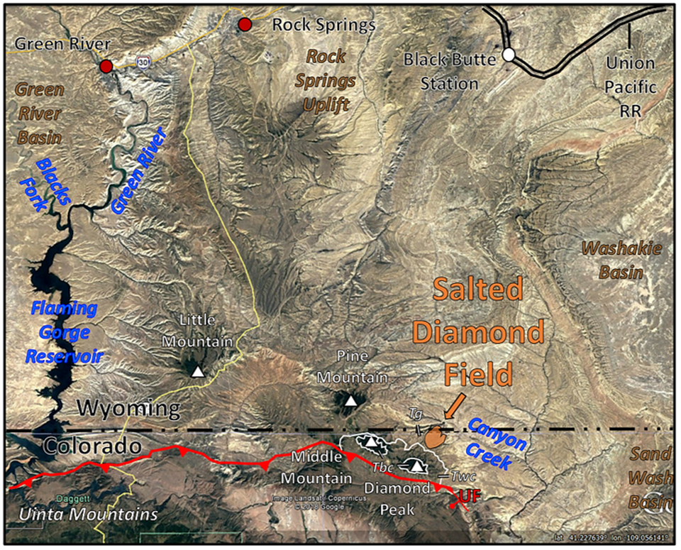

Top: Aerial view of the Great Diamond Hoax area. King’s 40th Parallel Survey route included the portion of Colorado in view. UT: Uinta Thrust, Tg: Green River Formation, Twc: Cathedral Peaks member of the Wasatch Formation, Tbc: Bishops Conglomerate. Bottom Left: 1907 photo of Black Butte Station. Bottom Right: The scene of the diamond field at Diamond Peak area. Red “X” marks the location of the first dinosaur found in Wyoming one-half mile east of the Black Buttes Station in 1872. Agathaumas sylvestris (great wonder of the forest) was a type of horned dinosaur (Ceratopsid) and the world’s first recognition of its type. The site is also important because it established a late Cretaceous age for the Lance Formation (then called Laramie Formation).
Images: Top: Left: Google Earth,
Bottom Left: U.S. Geological Survey, 1907 photograph,
Bottom Right: Diamond Peak Outfitters, https://static1.squarespace.com/static/54e241f2e4b006178718aa95/t/55248c1ae4b031e90a9120d9/1428458540533/diamond+peak+copy.jpg?format=2500w
Images: Top: Left: Google Earth,
Bottom Left: U.S. Geological Survey, 1907 photograph,
Bottom Right: Diamond Peak Outfitters, https://static1.squarespace.com/static/54e241f2e4b006178718aa95/t/55248c1ae4b031e90a9120d9/1428458540533/diamond+peak+copy.jpg?format=2500w

The swindlers Philip Arnold (left) and John Slack (right).
Image: http://www.freetoursbyfoot.com/what-was-the-great-san-francisco-diamond-hoax/
Image: http://www.freetoursbyfoot.com/what-was-the-great-san-francisco-diamond-hoax/

Some of the swindled rich investors. From top left: Asbury Harpending, financier; George B. McClellan, former Civil War General, Democratic Presidential candidate, and diamond company director; Horace Greely, editor of the New York Tribune; and former Republican Presidential candidate William Ralston, Bank of California founder; Charles Lewis Tiffany, jeweler; and Benjamin Butler, U.S. congressman and former Civil War General.
Image: http://1.bp.blogspot.com/-HWiu32Y4Q74/ULUVLnuJabI/AAAAAAAADmk/BCQQpCHT8pU/s1600/Arn.+%5B-+hoaxgang42707.jpg
Image: http://1.bp.blogspot.com/-HWiu32Y4Q74/ULUVLnuJabI/AAAAAAAADmk/BCQQpCHT8pU/s1600/Arn.+%5B-+hoaxgang42707.jpg
An additional $20,000 of London gems was purchased to further bait the trap at a secret location. They “salted” a plateau in the state line area at the foot of a mountain named Diamond Peak in Moffat County, Colorado, about 40 miles south of Black Buttes Station. Salting means they scattered their gem scraps around where potential investors could find them.
In a bit of subterfuge, the duo got the investors off the train at Rawlins Springs. This was eight stops east of the facility closest to the secret “diamond field,” Black Butte Station, Wyoming. A winding four-day horse trek, sometimes riding blindfolded, heightened the ruse. They reached the “diamond field” just across the state line into Colorado.
The area was located at the southern edge of the Greater Green River Basin, south of the Rock Springs Uplift and north of the Uinta Mountains thrust fault. South of Canyon Creek on a plateau below a mountain that would become known as Diamond Peak, lay the salted ground. Diamond Peak was an outcrop of Eocene age Bishop Conglomerate (Tbc) lying on top of Cathedral Peaks member of the Wasatch Formation (Twc). The sloping diamond field was composed of Green River Formation (Tg) that interfingers with the Wasatch units.
Henry Janin, a respected mining engineer hired by the investors, was convinced of the find and relayed the story in a chance meeting with a group of government surveyors on a train. Clarence King and his team decided to investigate the diamond field find because the discovery might be located within the limits of their 40th parallel survey they had just concluded. Geologic knowledge of diamond occurrence was in its infancy, but these scientists exposed the fraud. Three of the key observations were:
On the last observation, even the Man-of-Steel knew that precious stones were not made the same way.
In a bit of subterfuge, the duo got the investors off the train at Rawlins Springs. This was eight stops east of the facility closest to the secret “diamond field,” Black Butte Station, Wyoming. A winding four-day horse trek, sometimes riding blindfolded, heightened the ruse. They reached the “diamond field” just across the state line into Colorado.
The area was located at the southern edge of the Greater Green River Basin, south of the Rock Springs Uplift and north of the Uinta Mountains thrust fault. South of Canyon Creek on a plateau below a mountain that would become known as Diamond Peak, lay the salted ground. Diamond Peak was an outcrop of Eocene age Bishop Conglomerate (Tbc) lying on top of Cathedral Peaks member of the Wasatch Formation (Twc). The sloping diamond field was composed of Green River Formation (Tg) that interfingers with the Wasatch units.
Henry Janin, a respected mining engineer hired by the investors, was convinced of the find and relayed the story in a chance meeting with a group of government surveyors on a train. Clarence King and his team decided to investigate the diamond field find because the discovery might be located within the limits of their 40th parallel survey they had just concluded. Geologic knowledge of diamond occurrence was in its infancy, but these scientists exposed the fraud. Three of the key observations were:
- They discovered the area and found that the diamonds only occurred on disturbed ground (frequently ant hills) with footprints, and not in the bedrock (a sure sign of salting),
- Some of the stones showed signs of cutting (not natural but jewelers waste)
- The diamonds were found with rubies, emeralds and sapphires (precious stones not known to coexist in nature)
On the last observation, even the Man-of-Steel knew that precious stones were not made the same way.
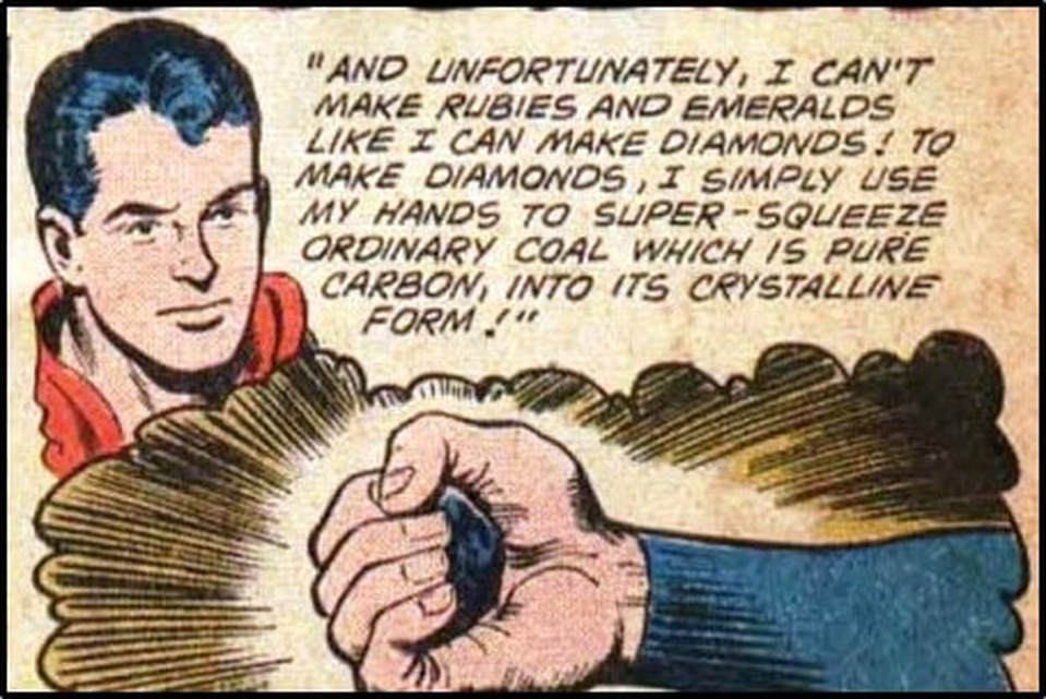
Another demonstration of the super-squeeze, coal-to-diamond myth. This is clear evidence that his super powers do not include geologic knowledge. Diamonds require high pressure, high temperature and geologic time to form. It is ironic that two kimberlite indicator minerals that form in the mantle beneath continental crust along with diamonds are called by jewelers Cape ruby (pyrope garnet) and Cape emerald (chromium diopside).
Image: https://pbs.twimg.com/media/CytwiCZWQAA3pa_.jpg
Image: https://pbs.twimg.com/media/CytwiCZWQAA3pa_.jpg
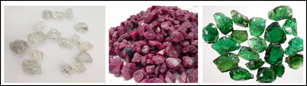
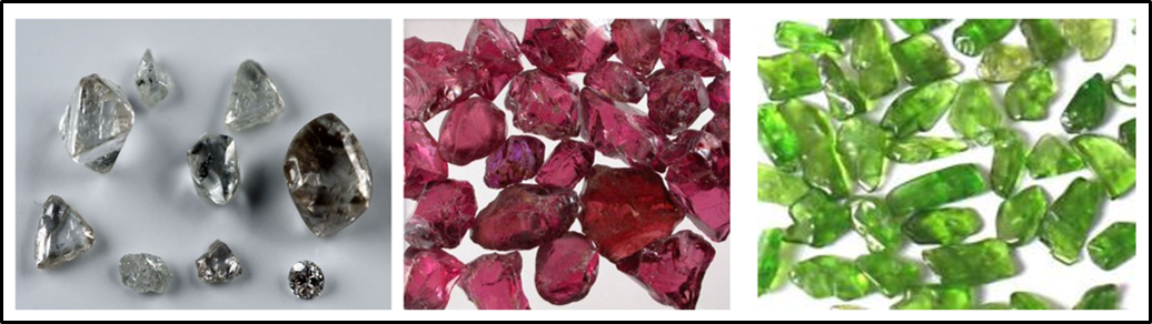
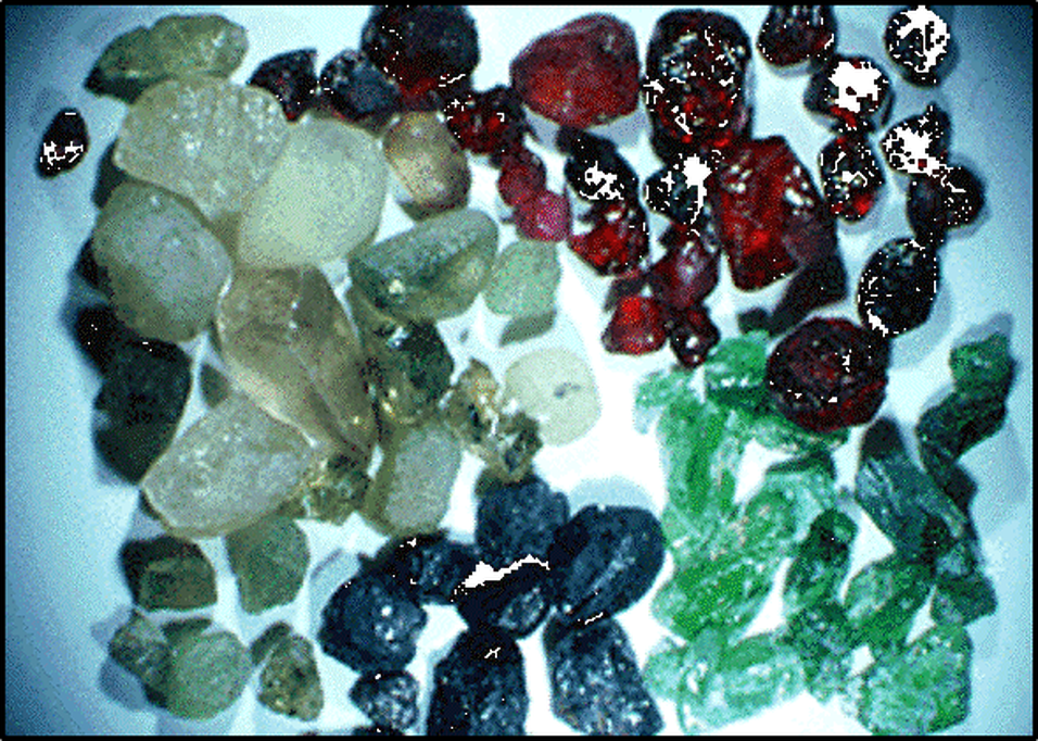
Could you tell the unnatural assortment of precious stones from the kimberlite indicator minerals? Top from left are diamonds, rubies and emeralds. Bottom from left are diamonds, pyrope, and Cr-diopside that form in the same mantle environment and are found in xenoliths in kimberlites.
Images: Top Left: Diamonds; Top Center: Rubies: http://gemstonesstock.blogspot.com/2013/10/gem-stones-ruby-natural-rough-uncut.html; Top Right Emeralds: http://www.minerals.net/gemstone/emerald_gemstone.aspx?img=/RoughImage/4/12/Emerald.aspx; Bottom Left: Diamonds: https://www.pinterest.com/pin/190277152979766893/; Bottom Center: Pyrope: https://m.minerals.net/Image/7/109/Pyrope.aspx, Right: Chromium Diopside: https://www.ebay.com/b/Chrome-Diopside-Loose-Stone-Beads/179273/bn_2186125
Images: Top Left: Diamonds; Top Center: Rubies: http://gemstonesstock.blogspot.com/2013/10/gem-stones-ruby-natural-rough-uncut.html; Top Right Emeralds: http://www.minerals.net/gemstone/emerald_gemstone.aspx?img=/RoughImage/4/12/Emerald.aspx; Bottom Left: Diamonds: https://www.pinterest.com/pin/190277152979766893/; Bottom Center: Pyrope: https://m.minerals.net/Image/7/109/Pyrope.aspx, Right: Chromium Diopside: https://www.ebay.com/b/Chrome-Diopside-Loose-Stone-Beads/179273/bn_2186125

Scientist heroes of the 40th Parallel Survey. Left: Left to right: James T. Gardner, Richard D. Cotter, William H. Brewer, and Clarence King. Right: Samuel F. Emmons, the geologist who missed the photo (perhaps his watch was set to geologic time).
Image Left: https://www.earthmagazine.org/article/november-261872-great-diamond-hoax-exposed/
Image Right: https://www.wyohistory.org/encyclopedia/diamond-hoax-bonanza-never-was
Image Left: https://www.earthmagazine.org/article/november-261872-great-diamond-hoax-exposed/
Image Right: https://www.wyohistory.org/encyclopedia/diamond-hoax-bonanza-never-was

Front page of the New York Sun for December 5, 1872.
Image: After https://www.newspapers.com/image/?spot=6936384
Image: After https://www.newspapers.com/image/?spot=6936384
Wyoming Diamond Field Fact
About 100 years later and 180 miles to the east, diamonds were discovered in the Wyoming/Colorado state line area near a mountain named Diamond Peak. The diamonds occur in Devonian age (416-349 million years ago) kimberlites near the south edge of the Wyoming Craton. Over 130,000 diamonds have been recovered from these kimberlites. In addition to industrial-grade diamonds, gem quality stones are produced here, including a 28.3 carat diamond discovered in 1996.
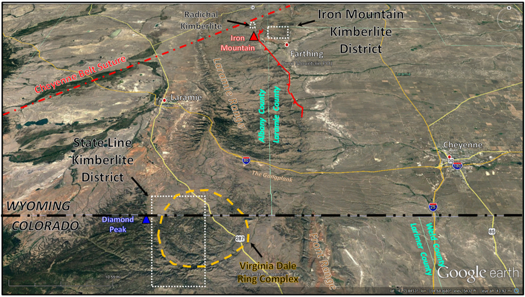
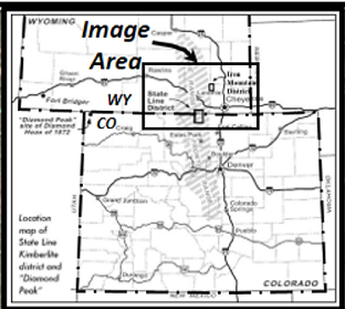
Wyoming Diamond Province showing kimberlite districts (white dotted lines) and the Virginia Dale ring complex (orange dashed line). Blue triangle: Diamond Peak, Larimer County, Colorado.
Image: Google Earth.
Image: Google Earth.
Diamonds crystallize within a discrete temperature and pressure range that exists in only one place on earth. They are formed from carbon in the uppermost mantle at depths of 90 to 120 miles (150-200 km) beneath the surface. That generally means beneath an Archean craton that has a thick lower lithospheric crust, sometime called a keel. Here temperatures range between 1,650 and 2,370 degrees F (900-1,300 C) with pressures reaching 650,000 to 870,000 psi (4.5 to 6 gigapascals, (Gpa)). The age of most diamonds ranges from 2.4 to 3.2 billion years.
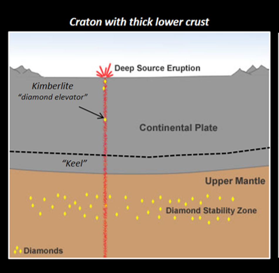
Habitat of diamond formation in the lithospheric mantle below old stable continental crust with a thick basal layer (keel).
Image: After https://geology.com/articles/diamonds-from-coal
Image: After https://geology.com/articles/diamonds-from-coal
Diamonds are transported to the surface as crystals (xenocrysts) or in diamond-bearing mantle rocks (xenoliths) by the explosive intrusion of melted ultramafic igneous rocks called kimberlites. They are mantle rocks that contain less than 45% silica (peridotite or eclogite). Thick continental crust is required to melt the mantle rocks that are the magma source. Emplacement of kimberlites forms subsurface deposits that are often “carrot shaped” in cross section. Only ten percent of kimberlites contain diamonds. Far fewer contain commercial quantities of stones. When diamonds in the stability zone encounter a kimberlite one of four options can result:
The explosive emplacement of igneous rocks can also detach chunks of surrounding rock, carrying them upward in the magma. Clasts of Lower Paleozoic rocks (Cambrian through Devonian) are found within the Wyoming/Colorado kimberlite province. The presence of lower Paleozoic xenoliths is what drew first attention to these “graben” deposits in 1960. Their presence was significant because the oldest sedimentary rock on the surface in this part of Wyoming is either early Mississippian Madison Limestone (359-350 million years ago) or late Pennsylvanian Fountain Arkose (340-290 million years ago). The Fountain Arkose is erosional debris from the Ancestral Rocky Mountains. This formation lies unconformably on the Precambrian granite. Prior to the discovery of the kimberlites, no Silurian age (444-416 million years ago) rock had ever been reported in the state of Wyoming. Geologists speculated that they were never deposited or were eroded before Devonian deposition (416-359 million years ago). An early Devonian age for the kimberlites was originally determined from fossils within the xenoliths. More recent radiometric dating work fission-track and rubidium-strontium methods established a late Devonian age of emplacement (358-359 million years ago).
- They move deeper into the mantle below the diamond stability zone and become free Carbon atoms;
- They rise to slowly and become graphite;
- They vaporize into carbon dioxide if they contact Oxygen while still hot;
- They cool rapidly due to the swift assent rate and are locked into their crystal shape.
The explosive emplacement of igneous rocks can also detach chunks of surrounding rock, carrying them upward in the magma. Clasts of Lower Paleozoic rocks (Cambrian through Devonian) are found within the Wyoming/Colorado kimberlite province. The presence of lower Paleozoic xenoliths is what drew first attention to these “graben” deposits in 1960. Their presence was significant because the oldest sedimentary rock on the surface in this part of Wyoming is either early Mississippian Madison Limestone (359-350 million years ago) or late Pennsylvanian Fountain Arkose (340-290 million years ago). The Fountain Arkose is erosional debris from the Ancestral Rocky Mountains. This formation lies unconformably on the Precambrian granite. Prior to the discovery of the kimberlites, no Silurian age (444-416 million years ago) rock had ever been reported in the state of Wyoming. Geologists speculated that they were never deposited or were eroded before Devonian deposition (416-359 million years ago). An early Devonian age for the kimberlites was originally determined from fossils within the xenoliths. More recent radiometric dating work fission-track and rubidium-strontium methods established a late Devonian age of emplacement (358-359 million years ago).
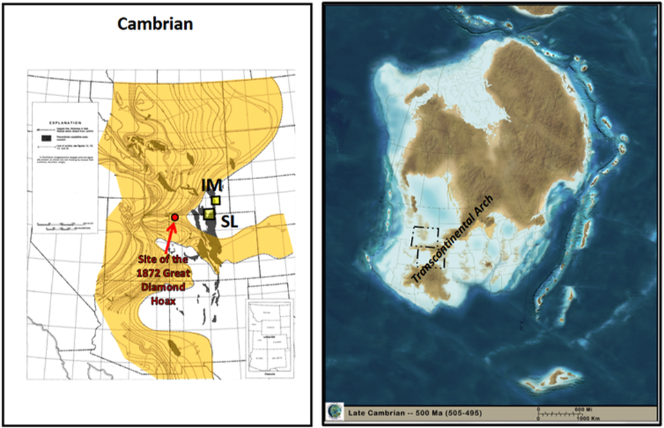
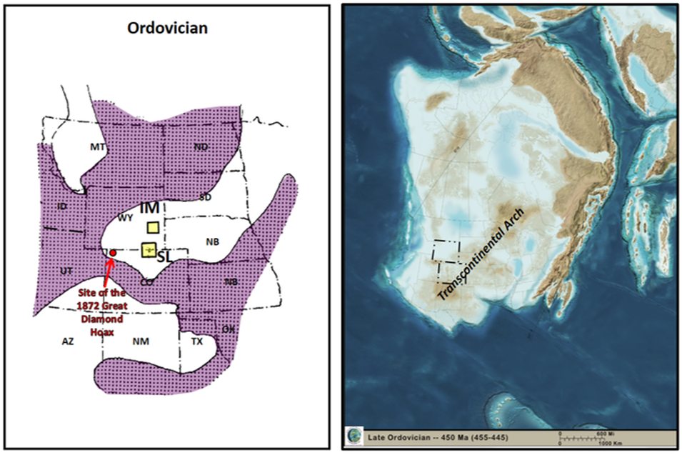

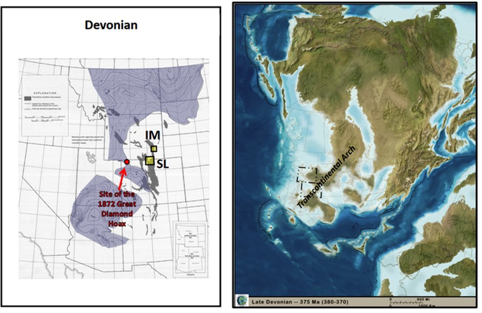
Previously known regional distribution and paleogeography of Cambrian through Devonian rocks. These lower Paleozoic rocks were interpreted to either be eroded before deposition of the upper Paleozoic units or had never been deposited due to a positive area from the Transcontinental Arch. The xenoliths found within the kimberlites establishes deposition in the area until at least late Devonian time. Wyoming Diamond Province: Iron Mountain (IM) and State Line kimberlite districts shown by yellow colored rectangles.
Image: Cambrian distribution: Lochman-Balk, C., 1972, Cambrian System in RMAG Geologic Atlas of the Rocky Mountain Region, Fig. 4, p. 64; Ordovician and Silurian distribution: Chronic, J., McCallum, M.E., Ferris, C.S., Jr., Eggler, D.H., 1969, Lower Paleozoic Rocks in Diatremes, Southern Wyoming and Northern Colorado: GSA Bulletin, Vol.80, Issue 1, Fig. 3, p. 155; Devonian distribution: Baars, D.L., 1972, Devonian System, in RMAG Geologic Atlas of the Rocky Mountain Region, Fig. 4, p. 94; Paleogeographic maps: Blakey, R., 2013, Key Time Slices of North American Geologic History DVD: Colorado Plateau Geosystem, Arizona, USA.
Image: Cambrian distribution: Lochman-Balk, C., 1972, Cambrian System in RMAG Geologic Atlas of the Rocky Mountain Region, Fig. 4, p. 64; Ordovician and Silurian distribution: Chronic, J., McCallum, M.E., Ferris, C.S., Jr., Eggler, D.H., 1969, Lower Paleozoic Rocks in Diatremes, Southern Wyoming and Northern Colorado: GSA Bulletin, Vol.80, Issue 1, Fig. 3, p. 155; Devonian distribution: Baars, D.L., 1972, Devonian System, in RMAG Geologic Atlas of the Rocky Mountain Region, Fig. 4, p. 94; Paleogeographic maps: Blakey, R., 2013, Key Time Slices of North American Geologic History DVD: Colorado Plateau Geosystem, Arizona, USA.

Tectonic Provinces of the Wyoming diamond districts. The districts are located on the Proterozoic Yavapai Province (aka Colorado Province) adjacent to the Wyoming Craton in yellow rectangles.
Image: After Hausel, D.W., 1984, Diamond-bearing Kimberlite Pipes in Wyoming and Colorado: Wyoming State Geological Survey Information Circular 23; http://www.wsgs.wyo.gov/products/wsgs-1984-mp-23.pdf
Image: After Hausel, D.W., 1984, Diamond-bearing Kimberlite Pipes in Wyoming and Colorado: Wyoming State Geological Survey Information Circular 23; http://www.wsgs.wyo.gov/products/wsgs-1984-mp-23.pdf
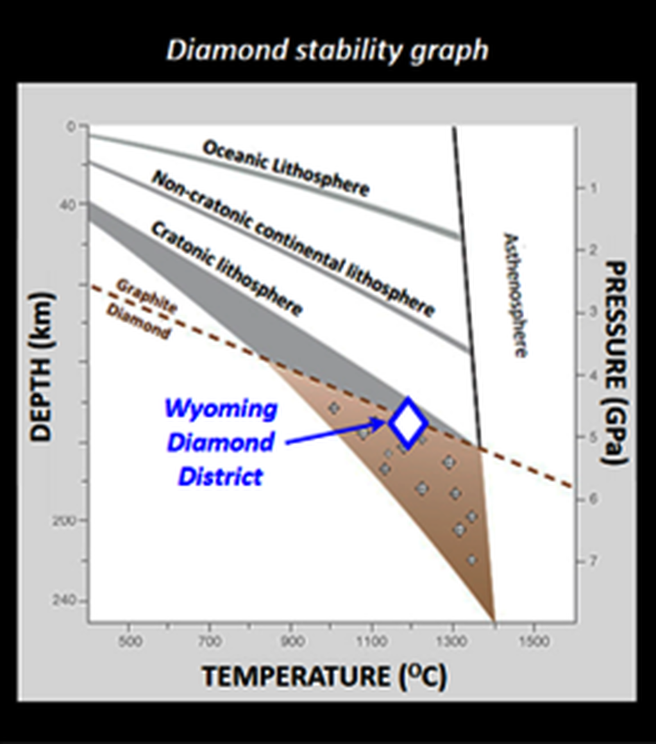
Depth-Temperature-Pressure graph of the diamond stability zone. Diamonds are formed at high temperature and pressure, deep beneath continental lithosphere.
Image: https://www.gia.edu/images/157605_WN13-Shirey-fig3.jpg
Image: https://www.gia.edu/images/157605_WN13-Shirey-fig3.jpg
Kimberlite emplacement produces conical deposits of extrusive rocks that are rarely preserved (as at Igwisi Hills, Tanzania). All the kimberlites in the Wyoming diamond province have undergone extensive erosion. Only the intrusive elements of the volcanic vent have been preserved. This adds to the difficulty of recognizing them. However, the removal of thousands of feet of kimberlite suggests that paleo stream sediments are good candidates for placer deposits. Placer diamonds account for about 48% of the world supply.
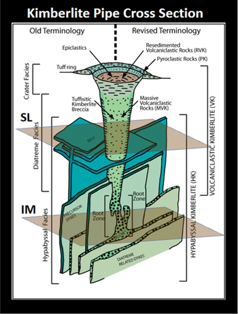
Cross section of a kimberlite that serves as the diamond elevator, showing “carrot shape.” The brown planes indicate the surface erosion level at the State Line (SL) and Iron Mountain (IM) districts.
Image: After Kjarsgaard, B.A., 2007. Kimberlite Diamond Deposits: Geological Association of Canada; https://www.stardiamondcorp.com/_resources/pdfs/Kjarsgaard-Kimberlite-Diamonds-Synthesis.pdf
Image: After Kjarsgaard, B.A., 2007. Kimberlite Diamond Deposits: Geological Association of Canada; https://www.stardiamondcorp.com/_resources/pdfs/Kjarsgaard-Kimberlite-Diamonds-Synthesis.pdf
Kimberlites can transport other minerals that also form in the mantle below cratonic crust. Because of their high density they can be found in stream beds and anthills, reflecting dispersal pattern of eroded kimberlites. This “indicator mineral” suite includes: pyrope garnet, chromite, ilmenite, clinopyroxene, olivine, and zircon.
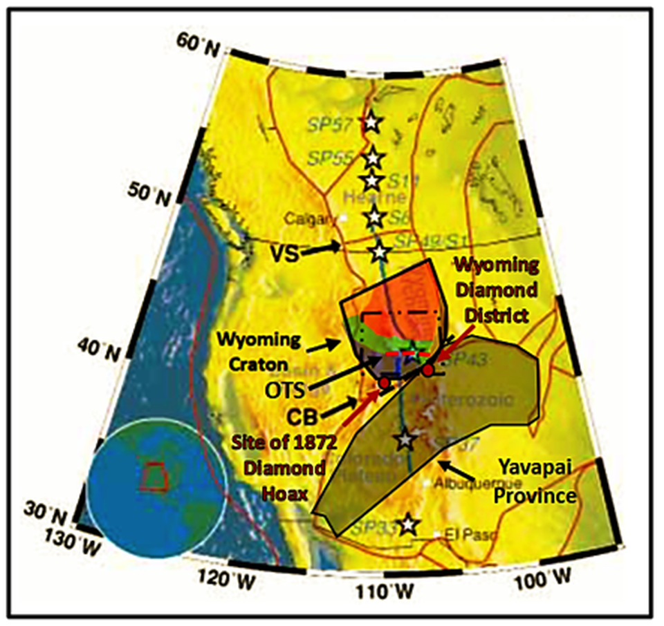
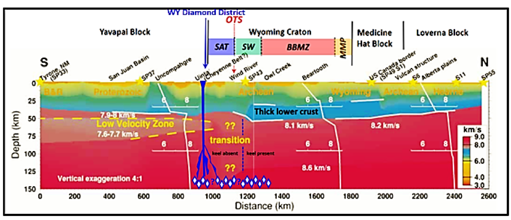
Top: Deep Probe refraction survey map Southern Alberta to New Mexico. The Wyoming Craton thick lower crustal layer is continuous to the Oregon Trail Structure (OTS: red dashed line). The Cheyenne Belt (CB: black dashed line) marks the boundary between Archean and Proterozoic crust. Bottom: Deep Probe refraction survey cross section. The thick lower crust is also called a lithospheric mantle “keel.” Presence of diamonds in the State Line area suggests that thick crust extended beneath the Proterozoic Yavapai crust until at least the Cretaceous. Tectonic magmatic activity destroyed this lower lithospheric layer. Kimberlite pipe shown in dark blue. Diamond habitat shown by dark blue outlined rhombi. Blue question marks indicate area of Proterozoic crust that was accreted to the Wyoming Craton along the Cheyenne Belt about 1.77 billion years ago. Cratonization began with the intrusion of the Sherman Granite 1.4 billion years before present. SAT: Southern Accreted Terrane subprovince, SW: Sweetwater subprovince, BBMZ: Beartooth-Bighorn Magmatic Zone subprovince, MMP: Montana Metasedimentary Province subprovince.
Image: After Henstock, T.J, Levander, A., Snelson, C.M., Keller, G.R., Miller, K.C., Harder, S. H., Gorman, A.R., Clowes, R.M., Burianyk, M.J.A., Humphreys, E.D., 1998, Probing the Archean and Proterozoic Lithosphere of Western North America: GSA Today, Vol.8, no. 7, Fig. 1 p. 1 and Fig. 3, p. 15-16. https://www.researchgate.net/publication/271133363_Probing_the_Archean_and_Proterozoic_lithosphere_of_western_North_America
Image: After Henstock, T.J, Levander, A., Snelson, C.M., Keller, G.R., Miller, K.C., Harder, S. H., Gorman, A.R., Clowes, R.M., Burianyk, M.J.A., Humphreys, E.D., 1998, Probing the Archean and Proterozoic Lithosphere of Western North America: GSA Today, Vol.8, no. 7, Fig. 1 p. 1 and Fig. 3, p. 15-16. https://www.researchgate.net/publication/271133363_Probing_the_Archean_and_Proterozoic_lithosphere_of_western_North_America
Diamond indicator minerals. Red: pyrope garnets, Green: chromium diopside (clinopyroxene), Black: ilmenite and chromite, Yellowish-green: olivine.
Image: Earth Science Australia website; http://earthsci.org/mineral/mindep/diamond/diamond.html#Indicator
Image: Earth Science Australia website; http://earthsci.org/mineral/mindep/diamond/diamond.html#Indicator
Colorado-Wyoming State Line Diamond District
The State Line District encompasses 50 square miles. It is 25 miles south of Laramie, WY, 33 miles east of Cheyenne, WY, and 32 miles northwest of Fort Collins, CO. The area bedrock is about 1.4 billion-year-old granite that intruded into a 1.75 billion-year-old metamorphic complex of the Yavapai Province. The Virginia Dale ring fracture complex is the major structural feature in the area. It formed during the intrusion of the Log Cabin batholith 1.4 billion years ago. The faults and fractures associated with this structure provided zones of weakness for the kimberlites to follow to the surface. State Line kimberlites have been eroded about 2,000 feet.
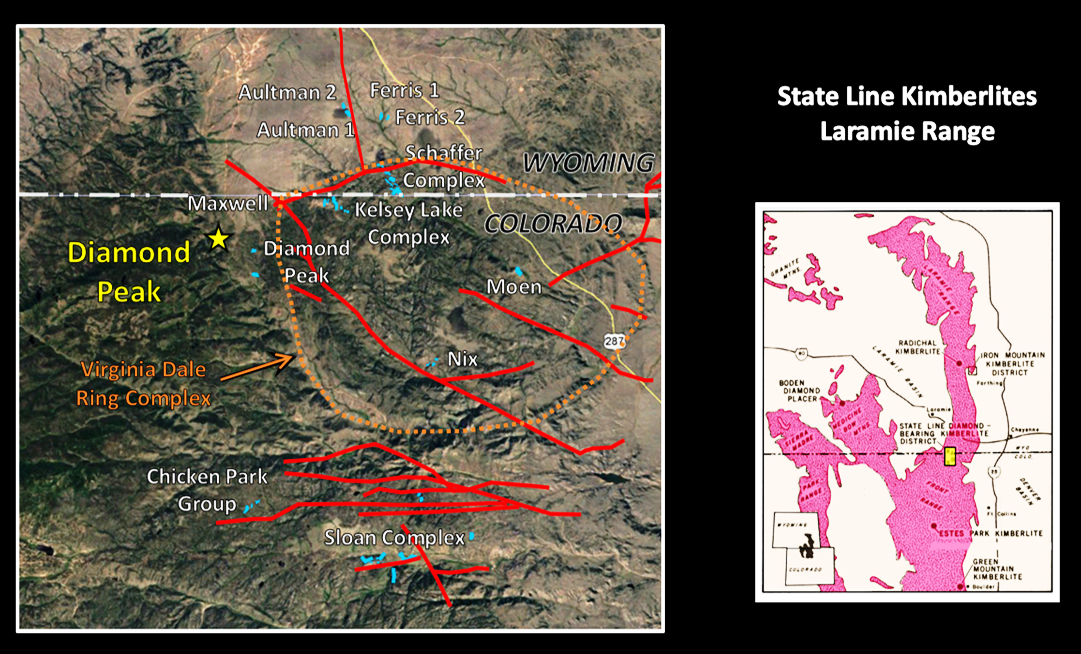
State Line Kimberlite District. Kimberlites shown in blue. Faults shown in red. The dashed orange line shows the outer ring of the Virginia Dale ring complex. This is an emplacement feature of the 1.39 billion-year-old intrusion of the Log Cabin batholite (Silver Plume Granite) into Sherman Granite. Devonian-age kimberlites exploited the fractures created by this intrusion.
Image: Left Base: Google Earth, Data: Hausel, W.D., 1998, Diamonds and Mantle Source Rocks in the Wyoming Craton with a Discussion of Other U.S. Occurrences: Wyoming State Geological Survey, Report of Investigations No. 53, Fig. 9, p. 16; http://www.wsgs.wyo.gov/products/wsgs-1998-ri-53.pdf
Image: Left Base: Google Earth, Data: Hausel, W.D., 1998, Diamonds and Mantle Source Rocks in the Wyoming Craton with a Discussion of Other U.S. Occurrences: Wyoming State Geological Survey, Report of Investigations No. 53, Fig. 9, p. 16; http://www.wsgs.wyo.gov/products/wsgs-1998-ri-53.pdf
Geologic investigation of the nature and petrology of the Wyoming/Colorado kimberlites has been ongoing since 1965. The first diamond was discovered from the Schaffer Kimberlite Complex, Wyoming. It was recognized not in the field but during routine thin section preparation in U.S. Geological Survey lab in Denver. The technician noticed that the weathered peridotite rock sample from a xenolith deeply scratched the carborundum plate (Mohs hardness: 9.0-9.5) grinding wheel. The only known rock that could do this was a diamond (Mohs hardness: 10.0). Microscope examination and X-ray diffraction analysis of small white crystals confirmed the presence of diamonds. The discovery was reported in a U.S. Geological Survey news release on June 10, 1975.
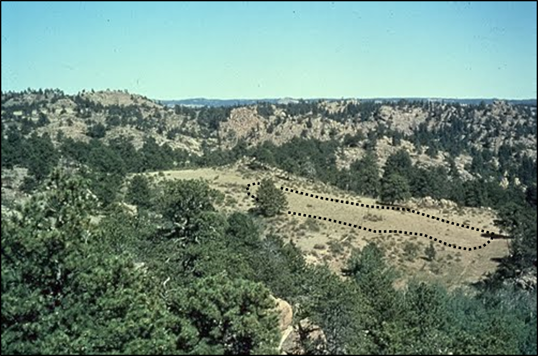
Aerial view of Schaffer Kimberlite, Wyoming outlined in the treeless, grassy hollow area.
Image: https://gemprospecting.blogspot.com/2017/10/diamonds-origin-occurrence-so-where.html?m=1
Image: https://gemprospecting.blogspot.com/2017/10/diamonds-origin-occurrence-so-where.html?m=1
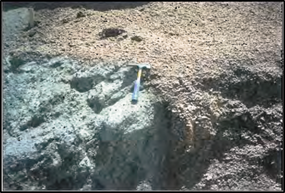
1980 close-up image of the razor-sharp kimberlite/granite contact in the Schaffer Kimberlite complex. Kimberlite “blue ground” (left) intruded into sheared Sherman Granite (right). The first diamond discovery in the Wyoming Diamond Province came from the Schaffer 3 kimberlite in 1975. Lack of wall rock (granite) alteration indicates a cold emplacement temperature. The temperature was reduced by the vast amount of CO2 that propelled the kimberlite to the surface.
Image: Hausel, W.D., 1998, Diamonds and Mantle Source Rocks in the Wyoming Craton with a Discussion of Other U.S. Occurrences: Wyoming State Geological Survey RI No. 53, Plate 2e, p. 17; http://sales.wsgs.wyo.gov/diamonds-and-mantle-source-rocks-in-the-wyoming-craton-with-a-discussion-of-other-u-s-occurrences-1998/
Image: Hausel, W.D., 1998, Diamonds and Mantle Source Rocks in the Wyoming Craton with a Discussion of Other U.S. Occurrences: Wyoming State Geological Survey RI No. 53, Plate 2e, p. 17; http://sales.wsgs.wyo.gov/diamonds-and-mantle-source-rocks-in-the-wyoming-craton-with-a-discussion-of-other-u-s-occurrences-1998/
Kelsey Lake complex, just south of Wyoming, was the only commercially mined kimberlite in the State Line District. Operations began in 1996. A new operator, who planned to use updated mining techniques, bought the property in 2000. Legal problems with property owners and changing markets led to the closing of the mine in 2001. At the time of closing, Denver Business Journal estimated the ore contained 60,000 and 250,000 carats of diamonds. The total weight of ore processed in the three kimberlites of the Wyoming portion of the Stateline district has been under 6,000 metric tons. The usual amount of ore tested for each kimberlite during feasibility studies is 10,000 metric tons.
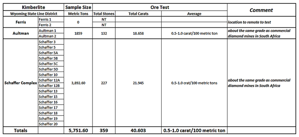
Sampling data for kimberlites in the Wyoming portion of the Colorado-Wyoming State Line District.
Image: Data from McCallum, M.E. and Waldman, M.A/, 1991, The Diamond Resources of the Colorado-Wyoming State Line Kimberlite Indicator Mineral Chemistry as a guide to economic potential, Wyoming Geological Association: Mineral Resources of Wyoming, Table 1, p. 82; and Colorado Geological Survey ROCKTALK, 1999, Vol. 2, No. 37, p. 7-8.
Image: Data from McCallum, M.E. and Waldman, M.A/, 1991, The Diamond Resources of the Colorado-Wyoming State Line Kimberlite Indicator Mineral Chemistry as a guide to economic potential, Wyoming Geological Association: Mineral Resources of Wyoming, Table 1, p. 82; and Colorado Geological Survey ROCKTALK, 1999, Vol. 2, No. 37, p. 7-8.
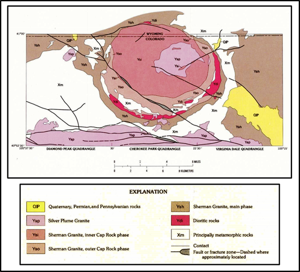
Geologic map of the nine-mile diameter Virginia Dale Ring Complex.
Image: Braddock, W.A., Eggler, D.H., and Courtright, T.R., 1989, Geologic map of the Virginia Dale quadrangle, Larimer County, Colorado, and Albany and Laramie Counties, Wyoming: U.S. Geological Survey Geologic Quadrangle Map GQ-1616, Scale: 1: 24,000; https://ngmdb.usgs.gov/Prodesc/proddesc_1140.htm
Image: Braddock, W.A., Eggler, D.H., and Courtright, T.R., 1989, Geologic map of the Virginia Dale quadrangle, Larimer County, Colorado, and Albany and Laramie Counties, Wyoming: U.S. Geological Survey Geologic Quadrangle Map GQ-1616, Scale: 1: 24,000; https://ngmdb.usgs.gov/Prodesc/proddesc_1140.htm
Wyoming Iron Mountain Diamond District
The Iron Mountain District lies 45 miles north of the State Line trend and encompasses an area of about 15 square miles. The district, located on the central east flank of the Laramie Range, is part of the Proterozoic Yavapai Province, just south of the Cheyenne Belt suture, about 24 miles southwest of Chugwater and four miles north of Farthing (formerly Iron Mountain). Prior to the kimberlite discoveries, the area had been known for titaniferous magnetite deposits, intermittently mined between 1872 to 1956, and the killing of 14-year-old Willie Nickell in 1901. This event occurred within the context of the cattle rancher/sheep herder conflict. Tom Horn, stock “detective,” was convicted and hung for the murder in 1902.
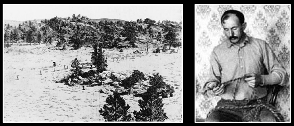
Left: 1902 photo of the murder site that sent legendary frontier cowboy Tom Horn to the gallows: Numbered locations: 1: assassin hiding spot; 2: spot in fence gap where Nickell’s was shot; 3: location where body found.
Right: Tom passing the time before his execution braiding rope in his Cheyenne jail cell. The 1980 movie, Tom Horn, while not filmed in Wyoming, does portray the Wyoming story from Horn’s autobiography written in jail.
Image: Left: Photo by W.G. Walker, 1902, in Ball, L. D., 2015, Tom Horn in Life and Legend, p. 297.; Right: https://upload.wikimedia.org/wikipedia/en/2/2c/Tom_Horn.jpg
The dominant structural feature in the district is the Cheyenne Belt suture between the Archean Wyoming Craton and the Yavapai Province. This tectonic suture formed between 1.8 and 1.68 billion years ago. Mississippian and younger rocks unconformably over lie the Sherman Granite in the area. The lower Paleozoic rocks were eroded prior to deposition of the younger units.
The Iron Mountain kimberlites were subjected to 4,000 to 5,000 feet of erosion after they were emplaced, exposing the roots and feeder-dike complex. The predominant dike orientation aligns with the trend of the Cheyenne Belt, indicating exploitation of fractures associated with this suture zone. At least three mining companies explored in the Iron Mountain area and took only a small number of samples for testing. Only a few diamonds were discovered, but the area remains largely untested. The second largest kimberlite field in the United States has only tested about 200 metric tons of ore, and thus remains largely unexplored.
The Iron Mountain kimberlites were subjected to 4,000 to 5,000 feet of erosion after they were emplaced, exposing the roots and feeder-dike complex. The predominant dike orientation aligns with the trend of the Cheyenne Belt, indicating exploitation of fractures associated with this suture zone. At least three mining companies explored in the Iron Mountain area and took only a small number of samples for testing. Only a few diamonds were discovered, but the area remains largely untested. The second largest kimberlite field in the United States has only tested about 200 metric tons of ore, and thus remains largely unexplored.
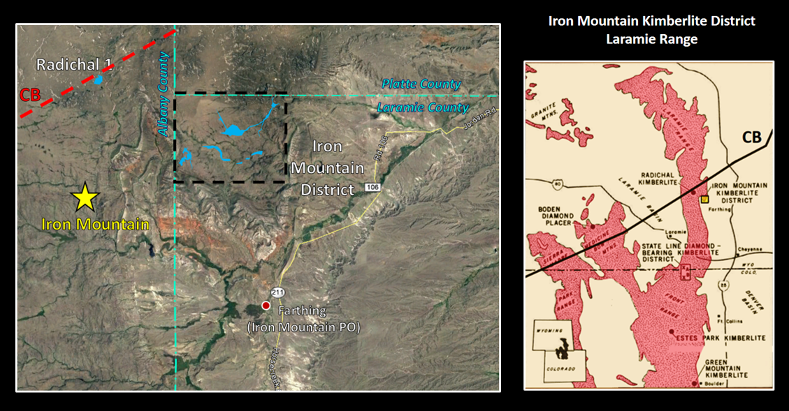
Iron Mountain Kimberlite District. Kimberlite dikes are shown in blue The Radichal 1 Kimberlite in the Middle Sybille Creek area is also shown. Left index map: CB: Cheyenne Belt tectonic suture.
Image: Left Base: Google Earth, Data: Hausel, W.D., Gregory, R.W., Motten, R.H., Sutherland, W.M., 2003, Geology of the Iron Mountain Kimberlite District and Nearby Kimberlitic Indicator Anomalies in Southeastern Wyoming: Wyoming State Geological Survey RI No. 54, Fig. 3, p. 6; http://sales.wsgs.wyo.gov/geology-of-the-iron-mountain-kimberlite-district-and-nearby-kimberlite-indicator-mineral-anomalies-in-southeastern-wyoming-2003/
Image: Left Base: Google Earth, Data: Hausel, W.D., Gregory, R.W., Motten, R.H., Sutherland, W.M., 2003, Geology of the Iron Mountain Kimberlite District and Nearby Kimberlitic Indicator Anomalies in Southeastern Wyoming: Wyoming State Geological Survey RI No. 54, Fig. 3, p. 6; http://sales.wsgs.wyo.gov/geology-of-the-iron-mountain-kimberlite-district-and-nearby-kimberlite-indicator-mineral-anomalies-in-southeastern-wyoming-2003/
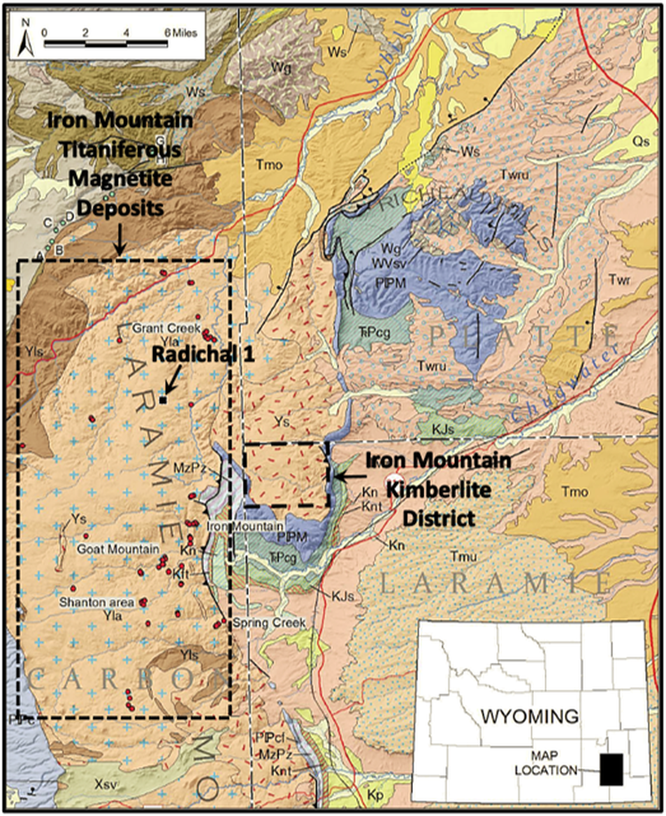
Iron Mountain area geologic map. Kimberlite district shown by black dashed line. Iron ore area shown within dotted outline. The ore lenses of titaniferous magnetite (red dots) are found in many locations within the Laramie Mountain Anorthosite Complex.
Image: After Sutherland, W.M., and Cola, E.C., 2015, Iron resources in Wyoming: Wyoming State Geological Survey Report of Investigations 67, Fig 15, p. 39; http://sales.wsgs.wyo.gov/iron-resources-in-wyoming-2015/
Image: After Sutherland, W.M., and Cola, E.C., 2015, Iron resources in Wyoming: Wyoming State Geological Survey Report of Investigations 67, Fig 15, p. 39; http://sales.wsgs.wyo.gov/iron-resources-in-wyoming-2015/
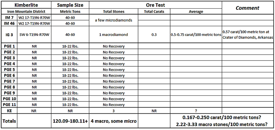
Sampling data for kimberlites in the Iron Mountain District.
Image: Data from Hausel, W.D., Gregory, R.W., Motten, R.H., and Sutherland, W.M., 2003, Geology of the Iron Mountain kimberlite district and nearby kimberlitic indicator mineral anomalies in southeastern Wyoming: Wyoming State Geological Survey Report of Investigations 54, 42 p., 3 pls., scale 1:100,000; http://www.wsgs.wyo.gov/products/wsgs-2003-ri-54.pdf
Image: Data from Hausel, W.D., Gregory, R.W., Motten, R.H., and Sutherland, W.M., 2003, Geology of the Iron Mountain kimberlite district and nearby kimberlitic indicator mineral anomalies in southeastern Wyoming: Wyoming State Geological Survey Report of Investigations 54, 42 p., 3 pls., scale 1:100,000; http://www.wsgs.wyo.gov/products/wsgs-2003-ri-54.pdf
Kimberlites in both the Iron Mountain and State Line Districts exhibit three surface features:
- Gray-blue soil surface with abundant calcium carbonate (blue ground),
- Circular or elliptical depressions that may hold water (kimberlite erodes more easily than the intruded granite), and
- Anomalies in vegetative patterns:
- Treeless area in a forested region, and
- Grass coverage is taller and denser than the surrounding area.

Close-up of grass anomaly and granite (left)/kimberlite (right) contact at Iron Mountain
Image: Hausel, W.D., Gregory, R.W., Motten, R.H., Sutherland, W.M., 2003, Geology of the Iron Mountain Kimberlite District and Nearby Kimberlitic Indicator Anomalies in Southeastern Wyoming: Wyoming State Geological Survey RI No. 54, Fig. 5, p. 7); http://sales.wsgs.wyo.gov/geology-of-the-iron-mountain-kimberlite-district-and-nearby-kimberlite-indicator-mineral-anomalies-in-southeastern-wyoming-2003/
Image: Hausel, W.D., Gregory, R.W., Motten, R.H., Sutherland, W.M., 2003, Geology of the Iron Mountain Kimberlite District and Nearby Kimberlitic Indicator Anomalies in Southeastern Wyoming: Wyoming State Geological Survey RI No. 54, Fig. 5, p. 7); http://sales.wsgs.wyo.gov/geology-of-the-iron-mountain-kimberlite-district-and-nearby-kimberlite-indicator-mineral-anomalies-in-southeastern-wyoming-2003/
Many publications are available for those wanting more information at the Wyoming State Geological Survey website: http://www.wsgs.wyo.gov/. The publications by W. Dan Hausel are particularly helpful for rock hounds and gem hunters.
The Great Diamond Hoax delayed serious exploration for diamonds in Wyoming and Colorado by a century. But over that time scientists learned that the entire Wyoming Craton, and the adjacent areas, have potential for kimberlites. Kimberlites are the primary volcanic vehicle to swiftly lift the precious stones to, or near the surface from their mantle stability zone. Wyoming hosts the two largest kimberlite districts in the United States. The diamond potential for mining and placer deposits remains good. There is another mantle-derived volcanic rock that can sometimes contain diamonds. It’s called lamproite … but that’s another story.
The Great Diamond Hoax delayed serious exploration for diamonds in Wyoming and Colorado by a century. But over that time scientists learned that the entire Wyoming Craton, and the adjacent areas, have potential for kimberlites. Kimberlites are the primary volcanic vehicle to swiftly lift the precious stones to, or near the surface from their mantle stability zone. Wyoming hosts the two largest kimberlite districts in the United States. The diamond potential for mining and placer deposits remains good. There is another mantle-derived volcanic rock that can sometimes contain diamonds. It’s called lamproite … but that’s another story.
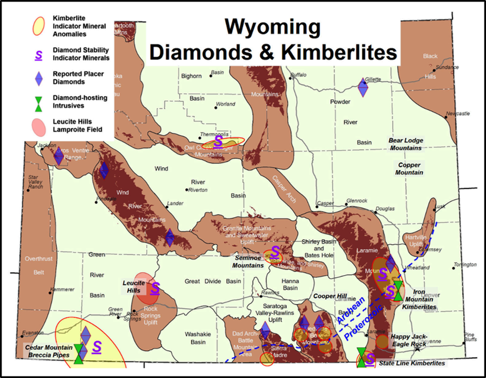
Diamond and kimberlite map of Wyoming. The State Line and Iron Mountain Districts are in the southeast corner of the state. Diamond potential extends throughout the Wyoming craton.
Image: http://www.wsgs.wyo.gov/docs/wsgs-web-diamonds-map.pdf
Image: http://www.wsgs.wyo.gov/docs/wsgs-web-diamonds-map.pdf

The material on this page is copyrighted