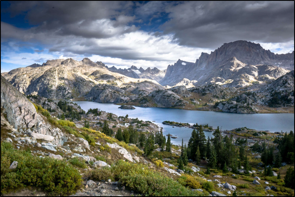
Titcomb Basin, Wind River Range, Wyoming.
Image: Simmerman, C., 2018 Backpacking to Titcomb Basin, Island Lake; https://cdn2.apstatic.com/photos/hike/7046341_large_1555534532.jpg.
Image: Simmerman, C., 2018 Backpacking to Titcomb Basin, Island Lake; https://cdn2.apstatic.com/photos/hike/7046341_large_1555534532.jpg.
Wow Factor (5 out of 5 stars):

Geologist Factor (4 out of 5 stars):

Attraction
Hidden deep in the Wind River Mountains, this alpine valley surrounded by 13,000 foot peaks is a premier hiking and climbing destination. It has lakes, glaciers, wildlife, wildflowers, solitude and lots of rocks! A true “bucket list” adventure.
Harold A. Titcomb graduated from Columbia School of Mines as a mining engineer in 1898. He began his career as an assistant superintendent for the Carissa gold mine at South Pass. His younger brother Charles was also employed and helped with mine surveys. The brothers spent their off hours hiking and climbing in the Wind River Range. They are the namesake for the Titcomb Basin, Lakes, and Needles. Together they made an ascent of Fremont Peak in 1901, the first men to stand on the summit since John C. Fremont stood in 1843.
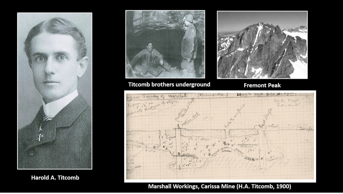
Titcomb montage. Titcomb became an internationally renowned mine engineer working throughout the United States, Mexico, South America, Eastern Europe, Russia, and Siberia.
Image: H.A. Titcomb, Titcomb brothers, and Marshall Workings sketch; After Lane, J. and Layman, S., 2012, South Pass City and the Sweetwater Mines, Images of America, Figs. On p. 35 & 36. Fremont Peak: After Kirk, J., 2008, Fremont Peak, Wyoming; https://listsofjohn.com/img/4/3985.jpg.
Image: H.A. Titcomb, Titcomb brothers, and Marshall Workings sketch; After Lane, J. and Layman, S., 2012, South Pass City and the Sweetwater Mines, Images of America, Figs. On p. 35 & 36. Fremont Peak: After Kirk, J., 2008, Fremont Peak, Wyoming; https://listsofjohn.com/img/4/3985.jpg.
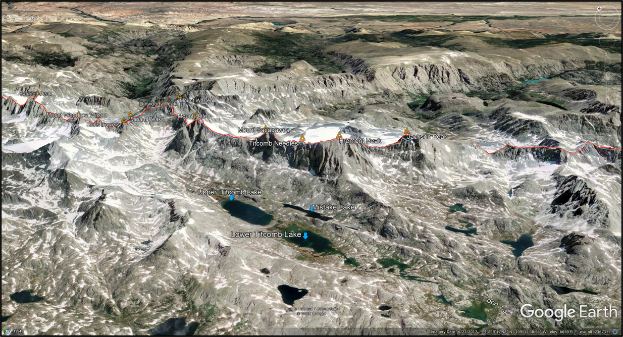
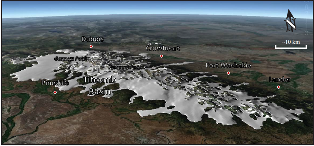
Northeast aerial view of the ice carved Titcomb Basina area, Wind River Range, Wyoming. Red line shows the approximate position of the Continental Divide.
Image: Google Earth
Image: Google Earth
Geology of Titcomb Basin
The basement rocks of the Wind River Range consist of ancient Archean granites, gneisses, and meta sedimentary units. Inclusions of zircon minerals within the rocks are dated at 3.82 billion years ago (Ga) indicate that Hadean crust (>3.8 Ga) was present in the area prior to the formation of gneiss or granite. During the late Archean, the western edge of the Wyoming craton was an active geologic margin. The regions geologic history is dominated by 250 million years of intrusion, five deformation events, and at least four periods of metamorphism (Frost, et al, 2000).
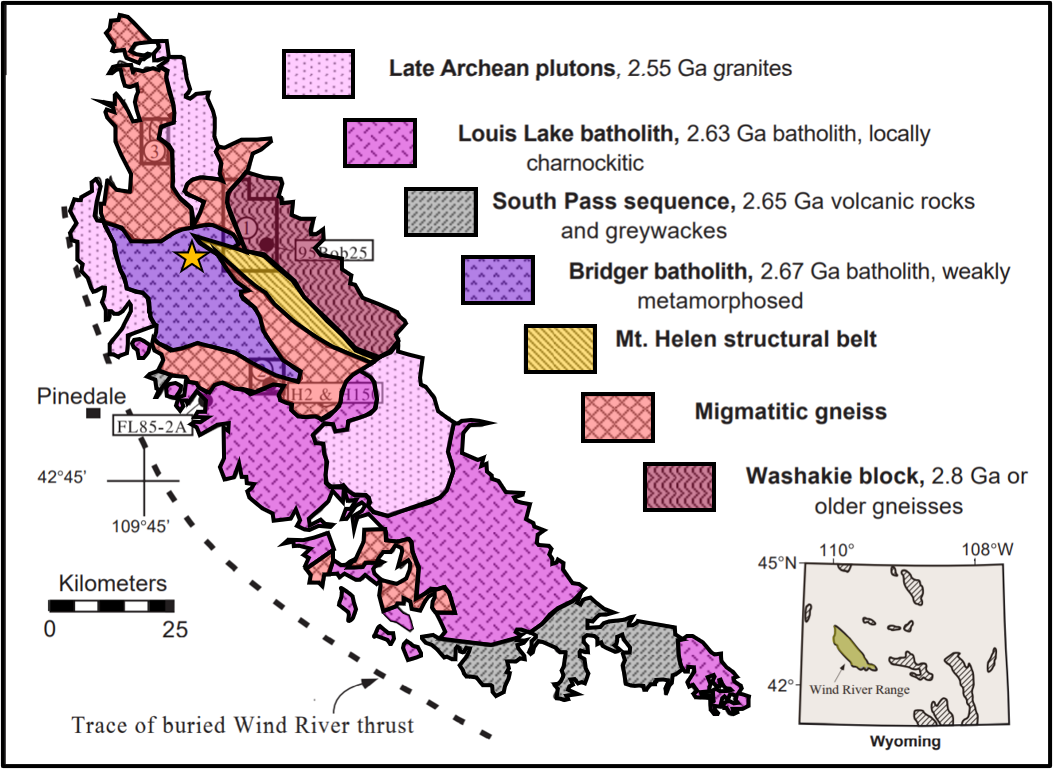
Precambrian basement rocks, Wind River Range, Wyoming. Titcomb Basin location indicated by gold star.
Image: After Frost, B.R., Chamberlain, B.R., Swapp, S., Frost, C.D., and Hulsebosch, T.P., 2000, Late Archean structural and metamorphic history of the Wind River Range: Evidence for a long-lived active margin on the Archean Wyoming craton: Geological Society of America Bulletin, Vol. 112, No. 4, Fig. 1, p. 565. https://terra.rice.edu/department/faculty/morganj/ESCI536/Readings/Frost-WindRiverGSABull2000.pdf
Image: After Frost, B.R., Chamberlain, B.R., Swapp, S., Frost, C.D., and Hulsebosch, T.P., 2000, Late Archean structural and metamorphic history of the Wind River Range: Evidence for a long-lived active margin on the Archean Wyoming craton: Geological Society of America Bulletin, Vol. 112, No. 4, Fig. 1, p. 565. https://terra.rice.edu/department/faculty/morganj/ESCI536/Readings/Frost-WindRiverGSABull2000.pdf
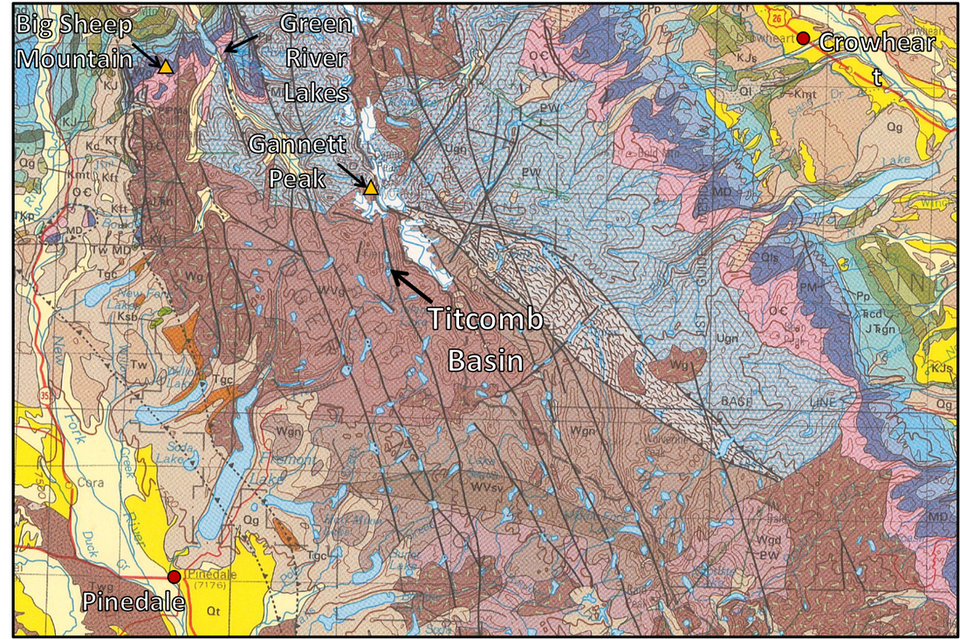

Geology map of northwest Wind River Mountains.
Image: Love, J.D., and Christiansen, A.C., comps., 1985, Geologic map of Wyoming: U.S. Geological Survey, 3 sheets, scale 1:500,000. (Re-released 2014, Wyoming State Geological Survey.) http://sales.wsgs.wyo.gov/geologic-map-of-wyoming-2014/
Image: Love, J.D., and Christiansen, A.C., comps., 1985, Geologic map of Wyoming: U.S. Geological Survey, 3 sheets, scale 1:500,000. (Re-released 2014, Wyoming State Geological Survey.) http://sales.wsgs.wyo.gov/geologic-map-of-wyoming-2014/
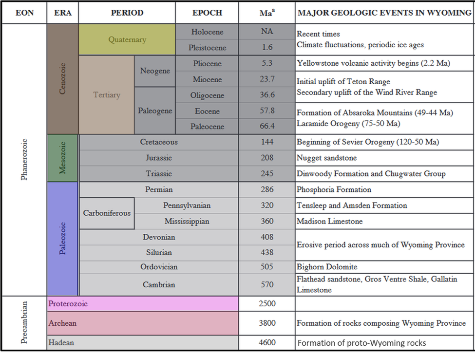
Timeline of major geologic events in Wyoming (millions of years ago Ma).
Image: After Wells, A.F., Boettinger, J.L., Houston, K.E., and Roberts, D.W., 2015, Ecological Types of the Eastern Slope of the Wind River Range, Shoshone National Forest, Wyoming. Gen. Tech. Rep. RMRS-GTR-345. Fort Collins, CO. U.S. Department of Agriculture, Forest Service, Rocky Mountain Research Station, Table 2, p. 8; https://www.fs.fed.us/rm/pubs/rmrs_gtr345.pdf.
Image: After Wells, A.F., Boettinger, J.L., Houston, K.E., and Roberts, D.W., 2015, Ecological Types of the Eastern Slope of the Wind River Range, Shoshone National Forest, Wyoming. Gen. Tech. Rep. RMRS-GTR-345. Fort Collins, CO. U.S. Department of Agriculture, Forest Service, Rocky Mountain Research Station, Table 2, p. 8; https://www.fs.fed.us/rm/pubs/rmrs_gtr345.pdf.
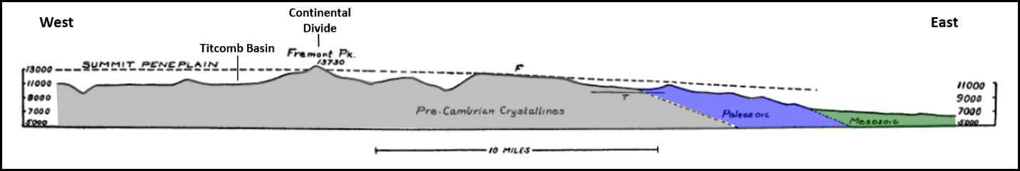
The Wind River block was thrust westward 16 miles laterally over Phanerozoic rocks during the late Cretaceous Laramide orogeny. This major uplift of the Wind River Mountains occurred in the Paleocene (66 million years ago) and ended by the Eocene (51 million years ago). Vertical separation on the Wind River thrust fault is over 9 miles.
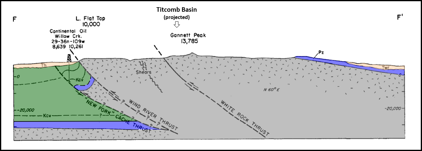
Structural cross section FF’ across Titcomb basin area, Wind River Range. West is on the left with the deep Green River Basin. East is on the right with just the edge of the Wind River Basin. The gray is Precambrian, the blue is Paleozoic, the green is Mesozoic, and the beige is Tertiary.
Image: After Blackstone, D.L., Jr., 1993, The Wind River Range, Wyoming: An Overview: Wyoming Geological Society Jubilee Anniversary Field Conference Guidebook: Wyoming Geology, Past, Present, and Future, Fig. 7, p. 126.
Image: After Blackstone, D.L., Jr., 1993, The Wind River Range, Wyoming: An Overview: Wyoming Geological Society Jubilee Anniversary Field Conference Guidebook: Wyoming Geology, Past, Present, and Future, Fig. 7, p. 126.
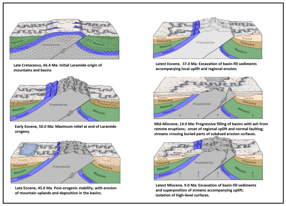
Evolution of Post-Laramide Wyoming topography. In the specific case of the Wind River Mountains, the Wind River Basin is on the left, the Green River Basin is on the right and the mountains are in the middle.
Image: After Mears, B., Jr., 1993, Geomorphic history of Wyoming and high-level erosion services, in Snoke, A.W., Steidtmann, J.R., and Roberts, S.M., editors, Geology of Wyoming: Geological Survey of Wyoming Memoir No. 5, Figs. 2-7, pp. 613-614; https://www.wsgs.wyo.gov/products/wsgs-1993-m-05.pdf.
Image: After Mears, B., Jr., 1993, Geomorphic history of Wyoming and high-level erosion services, in Snoke, A.W., Steidtmann, J.R., and Roberts, S.M., editors, Geology of Wyoming: Geological Survey of Wyoming Memoir No. 5, Figs. 2-7, pp. 613-614; https://www.wsgs.wyo.gov/products/wsgs-1993-m-05.pdf.
Laramide tectonism ended in the early Eocene. The mountain uplifts immediately began to erode into the surrounding basins. Volcanic eruptions added a tremendous volume of ash. During the late Eocene, Oligocene and Miocene, sediments progressively filled the basins and draped onto the mountains. Renewed erosion developed the high-level flat surface seen in the Wind River Mountains and other ranges of Wyoming. Canyons were cut by superposed streams.

High-level erosion surface beveling tilted Paleozoic rocks of Big Sheep Mountain (location on geology map above).
Image: Baker, C.L., 1946, Geology of the Northwestern Wind River Mountains, Wyoming: Bulletin of the Geological Society of America, Vol. 57, Plate 6, Fig. 2, p.586; https://mountainscholar.org/bitstream/handle/20.500.11919/6410/wsgs-1946-b-35.pdf?sequence=1
Image: Baker, C.L., 1946, Geology of the Northwestern Wind River Mountains, Wyoming: Bulletin of the Geological Society of America, Vol. 57, Plate 6, Fig. 2, p.586; https://mountainscholar.org/bitstream/handle/20.500.11919/6410/wsgs-1946-b-35.pdf?sequence=1
High level erosion surface (summit peneplain or plaination) near Fremont Peak.
Image: After Westgate, L.G., and Branson, E.B., 1913, The Later Cenozoic History of the Wind River Mountains, Wyoming: Journal of Geology, Vol. 21, No. 2, Fig. 2, p. 146; https://www.jstor.org/stable/pdf/30058362.pdf.
Image: After Westgate, L.G., and Branson, E.B., 1913, The Later Cenozoic History of the Wind River Mountains, Wyoming: Journal of Geology, Vol. 21, No. 2, Fig. 2, p. 146; https://www.jstor.org/stable/pdf/30058362.pdf.
The Pleistocene ice cap sculpted the exposed crystalline rock into cirque basins, scoured upland plateaus and morainal dammed lakes. Two major glacial periods shaped the mountain landscape. Bull Lake glaciation beginning 200,00 years ago and ending 130,00 years ago. The period is named for the moraines near Bull Lake on the eastern slope of the Wind River Mountains. Pinedale glaciation began about 30,000 years ago and ended 10,000 years ago.
Glacial timeline of the Wind River Range with approximate start and end times of important glacial and interglacial events (thousands of years ago Ka).
Image: After Wells, A.F., Boettinger, J.L., Houston, K.E., and Roberts, D.W., 2015, Ecological Types of the Eastern Slope of the Wind River Range, Shoshone National Forest, Wyoming. Gen. Tech. Rep. RMRS-GTR-345. Fort Collins, CO. U.S. Department of Agriculture, Forest Service, Rocky Mountain Research Station, Table 3, p.16; https://www.fs.fed.us/rm/pubs/rmrs_gtr345.pdf.
Image: After Wells, A.F., Boettinger, J.L., Houston, K.E., and Roberts, D.W., 2015, Ecological Types of the Eastern Slope of the Wind River Range, Shoshone National Forest, Wyoming. Gen. Tech. Rep. RMRS-GTR-345. Fort Collins, CO. U.S. Department of Agriculture, Forest Service, Rocky Mountain Research Station, Table 3, p.16; https://www.fs.fed.us/rm/pubs/rmrs_gtr345.pdf.
Pinedale ice cap, Wind River Range during last glacial maximum.
Image: After Birkel, S.D., Putnam, A.E., Denton, G.H., Koons, P.O., Fastook, J.L., Putnam, D.E., and Maasch, K.A., 2012, Climate Inferences from a Glaciological Reconstruction of the Late Pleistocene Wind River Ice Cap, Wind River Range, Wyoming: Arctic, Antarctic, and Alpine Research, Vol. 44, No. 3, Fig. 8, p. 273; https://www.tandfonline.com/doi/pdf/10.1657/1938-4246-44.3.265?needAccess=true.
Image: After Birkel, S.D., Putnam, A.E., Denton, G.H., Koons, P.O., Fastook, J.L., Putnam, D.E., and Maasch, K.A., 2012, Climate Inferences from a Glaciological Reconstruction of the Late Pleistocene Wind River Ice Cap, Wind River Range, Wyoming: Arctic, Antarctic, and Alpine Research, Vol. 44, No. 3, Fig. 8, p. 273; https://www.tandfonline.com/doi/pdf/10.1657/1938-4246-44.3.265?needAccess=true.
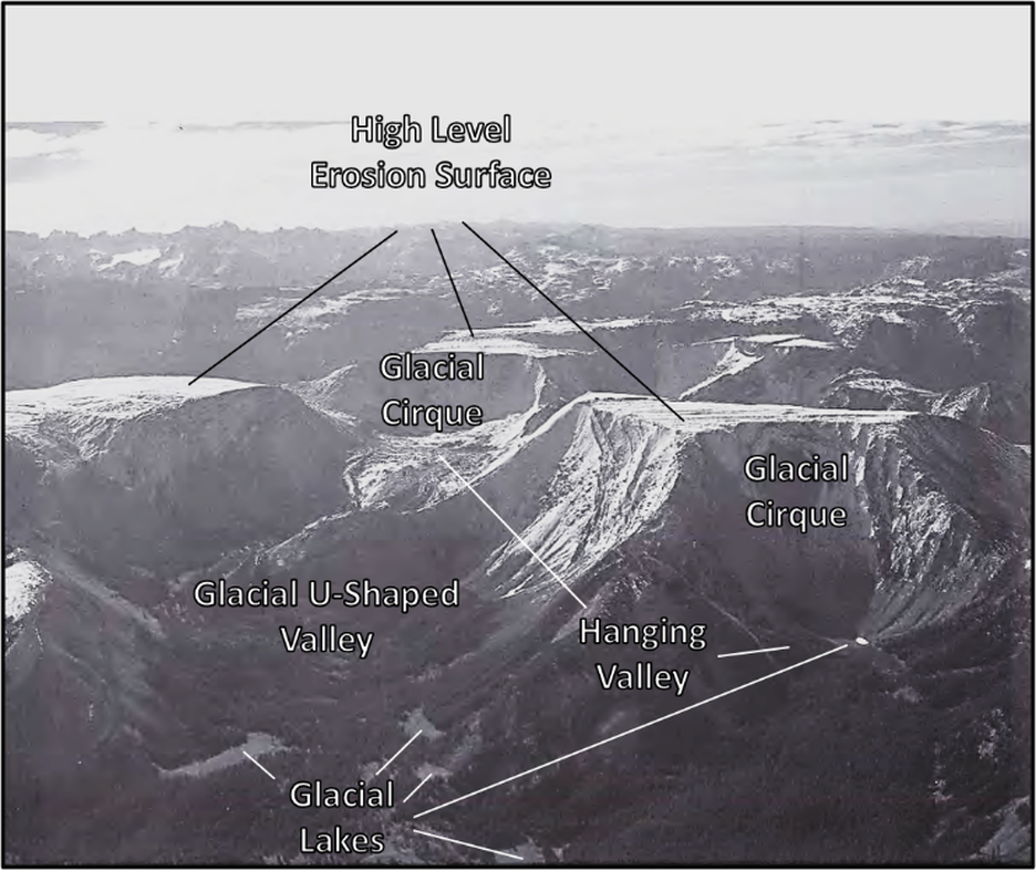
Aerial view of northwestern Wind River Range. The Tertiary high-level erosion surface is at about 11,000 foot elevation in this area. The cirques, hanging valleys, and troughs are the result of Pleistocene glacial carving. This landscape is called “biscuit board topography” for its resemblance to the dough left on the board after the biscuits have been cut. Flat-top mountain in right foreground is Gypsum Mountain, just west of Big Sheep Mountain.
Image: After Lageson, D.R., 1986, from Mears, B., Jr., 1993, Geomorphic history of Wyoming and high-level erosion surfaces; in Snoke, A.W., Steidtmann, J.R., and Roberts, S.M., eds., 1993, Geology of Wyoming: Geological Survey of Wyoming [Wyoming State Geological Survey] Memoir 5, Vol. 2, Frontispiece, p. 608; https://www.wsgs.wyo.gov/products/wsgs-1993-m-05.pdf.
Image: After Lageson, D.R., 1986, from Mears, B., Jr., 1993, Geomorphic history of Wyoming and high-level erosion surfaces; in Snoke, A.W., Steidtmann, J.R., and Roberts, S.M., eds., 1993, Geology of Wyoming: Geological Survey of Wyoming [Wyoming State Geological Survey] Memoir 5, Vol. 2, Frontispiece, p. 608; https://www.wsgs.wyo.gov/products/wsgs-1993-m-05.pdf.
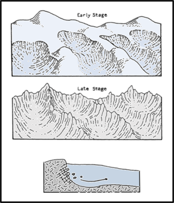
Cirque is a basin (amphitheater) eroded into a mountainside at the head of a glacier, where ice flowing downslope plucks blocks of jointed rock. Diagram shows the formation of cirques and “biscuit board topography.”
Image: After Guyton, B., 1998, Glaciers of California: Modern Glaciers, Ice Age Glaciers, the Origin of Yosemite Valley, and a Glacier Tour in the Sierra Nevada, Fig. 19, p. 48.
Image: After Guyton, B., 1998, Glaciers of California: Modern Glaciers, Ice Age Glaciers, the Origin of Yosemite Valley, and a Glacier Tour in the Sierra Nevada, Fig. 19, p. 48.
Things To Do
This is an adventure only for the physically fit and you should plan multiple days for the trip. The following two websites have useful maps and insights: Hiking Project and AllTrails.
- Backpacking
- Camping
- Photography
- Climbing
- Fishing
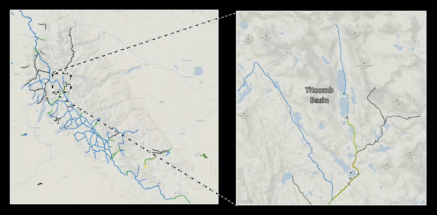
Titcomb Basin trails.
Image: After https://www.hikingproject.com/directory/8014039/wind-river-range.
Image: After https://www.hikingproject.com/directory/8014039/wind-river-range.

The material on this page is copyrighted