Wow Factor (2 out of 5 stars):
Geologist Factor (5 out of 5 stars):
Geology of K-T Boundary
An asteroid is travelling through space on a collision course with the earth. The object is 7 to 50 miles in diameter and is moving at over 36,000 miles per hour (more than 45 times the speed of sound) toward a spot in the shallow waters of the Gulf of Mexico. It is 65 million years ago, and dinosaurs have dominated the planet for about the last 150-200 million years. Mammals were small rat-like creatures living in underground burrows or the water.
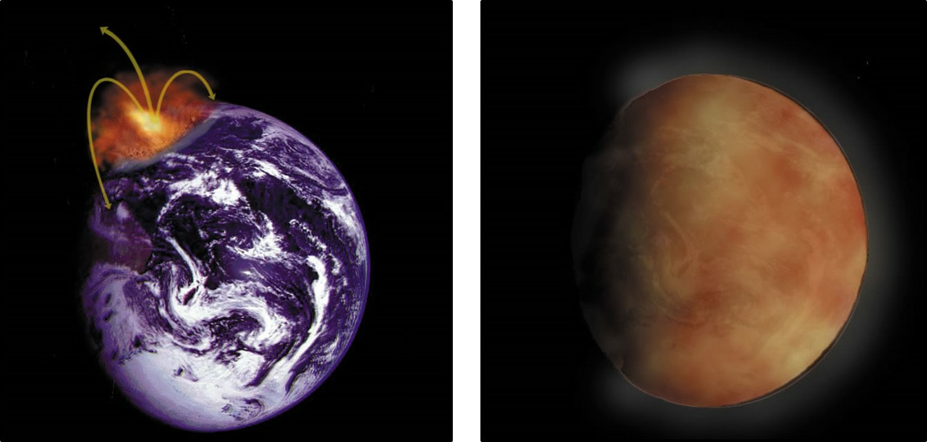
In Wyoming’s Powder River Basin, the dinosaurs were moving along the swampy alluvial plains of the Lance Formation eating, drinking and doing other necessary dinosaur things. A flash in the sky, is noticed by some, but none know their time on earth is about to rapidly end. The asteroid has hit the earth at a 20 to 30-degree angle just offshore of the Yucatan Peninsula. It made a crater 110 miles in diameter and 12 miles deep. The energy released is estimated to be equivalent to 10 billion Hiroshima atomic bombs. Tons of rock were vaporized and blown into the stratosphere. Because of the abundant anhydrite in the mid Jurassic Louann salt where the asteroid hit, there was a massive release of sulfur to the upper atmosphere. Within a quarter hour, low energy ejecta blasted from the Yucatan Peninsula begins to rain down on the Powder River Basin. While the low energy ejecta was still travelling north, high energy ejecta were raining fireballs at the top of the atmosphere. Tsunamis flooded coastal areas, and the increasing air temperature ignited vegetation to create firestorms (produced soot in carbonaceous units). The global dust cloud blocked the sun, stopped photosynthesis and collapsed the food chain.
In Wyoming’s Powder River Basin, the dinosaurs were moving along the swampy alluvial plains of the Lance Formation eating, drinking and doing other necessary dinosaur things. A flash in the sky, is noticed by some, but none know their time on earth is about to rapidly end. The asteroid has hit the earth at a 20 to 30-degree angle just offshore of the Yucatan Peninsula. It made a crater 110 miles in diameter and 12 miles deep. The energy released is estimated to be equivalent to 10 billion Hiroshima atomic bombs. Tons of rock were vaporized and blown into the stratosphere. Because of the abundant anhydrite in the mid Jurassic Louann salt where the asteroid hit, there was a massive release of sulfur to the upper atmosphere. Within a quarter hour, low energy ejecta blasted from the Yucatan Peninsula begins to rain down on the Powder River Basin. While the low energy ejecta was still travelling north, high energy ejecta were raining fireballs at the top of the atmosphere. Tsunamis flooded coastal areas, and the increasing air temperature ignited vegetation to create firestorms (produced soot in carbonaceous units). The global dust cloud blocked the sun, stopped photosynthesis and collapsed the food chain.
Chicxulub asteroid impact, first hour (left) and after several days when dust has covered the globe and blocked the sun (right).
Image:Bailey, J., 2002, Environmental Effects of Impact Cratering Poster: NASA/ University of Arizona Space Imaging Center; https://www.lpi.usra.edu/exploration/training/illustrations/chicxulub-effects/.
Image:Bailey, J., 2002, Environmental Effects of Impact Cratering Poster: NASA/ University of Arizona Space Imaging Center; https://www.lpi.usra.edu/exploration/training/illustrations/chicxulub-effects/.
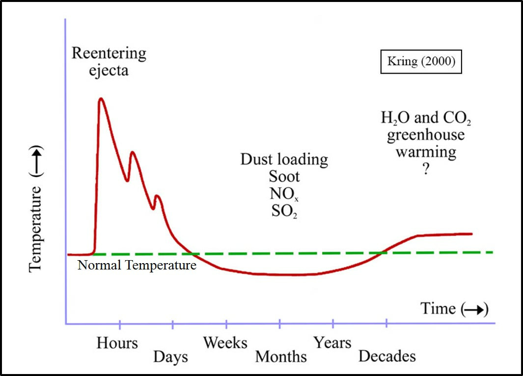
The timing and temperature effect of asteroid impact debris. Mammals were able to survive in their underground burrows or water. They were able to eat insects and aquatic fauna and not rely on plants as did most of the dinosaur. The firestorms in the first few days killed a large volume of the dinosaur population.
Image: After Bailey, J., 2002, Environmental Effects of Impact Cratering Poster: NASA/ University of Arizona Space Imaging Center; https://www.lpi.usra.edu/exploration/training/illustrations/chicxulub-effects/.
Image: After Bailey, J., 2002, Environmental Effects of Impact Cratering Poster: NASA/ University of Arizona Space Imaging Center; https://www.lpi.usra.edu/exploration/training/illustrations/chicxulub-effects/.
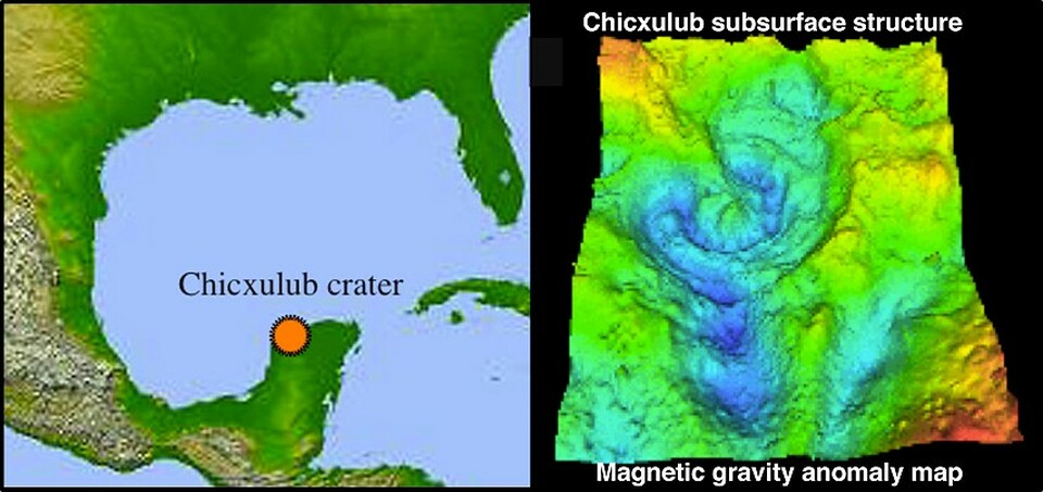
Location of the Chicxulub crater, Yucatan Peninsula, Mexico (left); magnetic gravity map of crater (right).
Image: Keller, G., Chicxulub: The Impact Controversy Website, Fig. 4; https://massextinction.princeton.edu/chicxulub/2-impact-controversary.
Image: Keller, G., Chicxulub: The Impact Controversy Website, Fig. 4; https://massextinction.princeton.edu/chicxulub/2-impact-controversary.
The discovery of the Cretaceous-Tertiary boundary clay and its connection to the extinction of the dinosaurs is an example of science at its best. The story begins with an observation of geologist Walter Alverez while investigating a feature discovered in the emerging plate tectonics theory. He was searching for magnetic reversals in continental sedimentary rocks when he recognized a persistent layer of rock lying between the uppermost Cretaceous and lowermost Tertiary rocks in the carbonate rocks of the Apennine Mountains, Italy. This boundary layer occurred about 65 million years ago and consisted of a lower layer of sedimentary rock rich with a wide variety of marine fossils, a centimeter-thick layer of claystone devoid of all fossils, and an upper layer of sedimentary rock containing a substantially reduced variety of marine fossils.
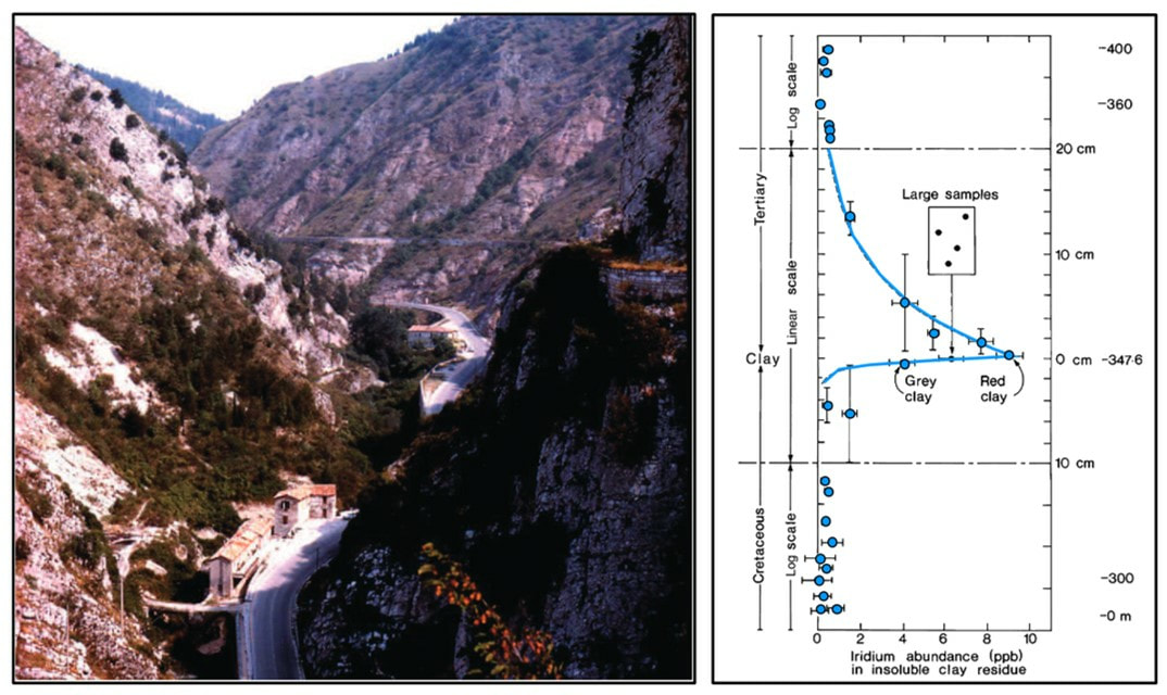
He discussed these findings with his physicist father, Luis Alverez, who suggested measuring the radiation level of the clay layer to determine how fast the clay layer was deposited. A large “iridium anomaly” was discovered (almost 10 parts per billion (ppb); 30 times the expected maximum value; background level is about 0.03 ppb).
He discussed these findings with his physicist father, Luis Alverez, who suggested measuring the radiation level of the clay layer to determine how fast the clay layer was deposited. A large “iridium anomaly” was discovered (almost 10 parts per billion (ppb); 30 times the expected maximum value; background level is about 0.03 ppb).
Left: The Bottaccione Gorge in the mountains behind Gubbio, looking towards the north-east. The large mountain in the rear is made of Upper Cretaceous and Paleocene Scaglia Rossa Formation, dipping moderately away from the viewer. The horizontal structure is a medieval aqueduct that supplied Gubbio with water. Right: The first plot of the Cretaceous-Tertiary boundary iridium anomaly.
Image: After Alverez, W., 2009, The historical record in the Scaglia limestone at Gubbio: magnetic reversals and the Cretaceous-Tertiary mass extinction: Sedimentology 56, Fig. 7, p. 46; https://usm.maine.edu/sites/default/files/The%20Collaborative%20of%20Global%20and%20Big%20History/Alvarez,%20145%20Gubbio%20review%20Sedgy%202009.pdf.
Image: After Alverez, W., 2009, The historical record in the Scaglia limestone at Gubbio: magnetic reversals and the Cretaceous-Tertiary mass extinction: Sedimentology 56, Fig. 7, p. 46; https://usm.maine.edu/sites/default/files/The%20Collaborative%20of%20Global%20and%20Big%20History/Alvarez,%20145%20Gubbio%20review%20Sedgy%202009.pdf.
Another “iridium anomaly” of the same age was discovered in Denmark, which showed the deposition of the clay layer was instantaneous and widespread. This anomaly occurred at the same time as a major extinction event. The clay contained shocked quartz that is produced by an explosion or impact. The suggestion that the layer was caused by a supernova was quashed because the clay was found to contain no plutonium 244 isotope (supernova produce plutonium 244). Luis Alverez suggested an asteroid impact would fit the available data. The dust cloud arising from the impact would block sunlight, stop photosynthesis, and collapse the food chain bringing on the extinction of the dinosaurs. The team published their findings in a 1980 Science paper.
Left: 1981 photo of Luis (left) and Walter (right) Alverez at a limestone outcrop in Bottaccione Gorge, near Gubbio, Italy. Walter’s right hand is touching the top of the Cretaceous limestone, at the K-T boundary in 1981. Right: Detail image of the boundary level.
Image: Left: https://en.wikipedia.org/wiki/Alvarez_hypothesis; Right: http://www.liber-lapidum.net/imgitaly.html.
Image: Left: https://en.wikipedia.org/wiki/Alvarez_hypothesis; Right: http://www.liber-lapidum.net/imgitaly.html.
Further investigation by other scientists found the “iridium anomaly” was a global event related to the extinction of the dinosaurs. Debate continued as to what caused the iridium layer. The Deccan traps of India (volcanoes) was a candidate due to the increase of atmospheric greenhouse gases produced over a longer time. Dating of the eruption found that they began before the asteroid impact, and the rate of flow doubled after the impact. The amount of seismic energy from the impact travelled around the globe to increase eruption of the basalt.
In 1978, GlenPenfield,a geophysicist working for Pemex, the Mexican state-owned petroleum company, discovered the Chicxulub crater on a magnetic survey map. The information was held confidential to Pemex. It was years before the information was made public and confirmed the asteroid impact theory.
Because all reported K-T boundary anomalies where in marine rocks, the Los Alamos National Laboratory began to search for the iridium anomaly in continental rocks. The first continental discovery was made in a core from York Canyon in northeast New Mexico. The team used palynology to zero in on the anomaly. The K-T boundary consisted of a lower thick claystone layer (aka kaolinite layer or K/T boundary claystone)and an upper thin layer (aka fireball, magic, K-T boundary impact layer) with a high concentration of iridium, most of the shocked quartz and a composition of kaolinite and illite/smectite mixed layer clay.
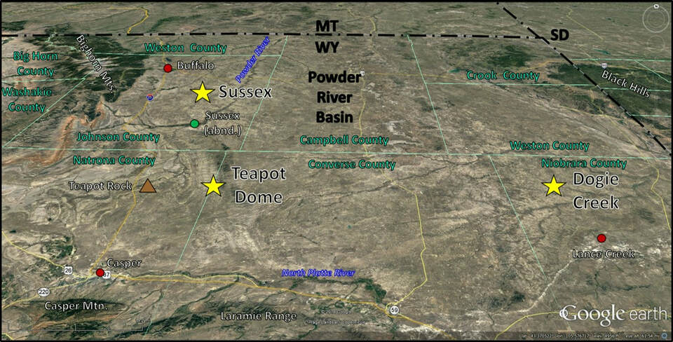
Powder River Basin K-T Boundary Localities
North aerial view of the identified Powder River Basin K-T boundary clay locations (yellow stars)
Image: Google Earth
Image: Google Earth
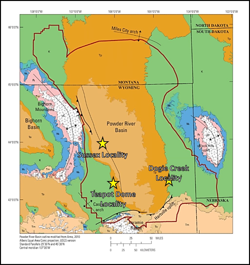
Generalized Powder River Basin geologic map showing location of K-T Boundary sites (yellow Star).
Image: After William H. Craddock, W.H., Drake, R.M., II, Mars, J.C., Merrill, M.D., Warwick, P.D., Blondes, M.S., Gosai, M.A., Freeman, P.A., Cahan, S.M., DeVera, C.A., and Lohr, C.D., 2012, Geologic Framework for the National Assessment of Carbon Dioxide Storage Resources ─ Powder River Basin, Wyoming, Montana, South Dakota, and Nebraska, Chapter B: U.S. Geological Survey Open File Report 2012-1024-B, Fig. 1, p. 4; https://pubs.usgs.gov/of/2012/1024/b/OF12-1024B.pdf.
Image: After William H. Craddock, W.H., Drake, R.M., II, Mars, J.C., Merrill, M.D., Warwick, P.D., Blondes, M.S., Gosai, M.A., Freeman, P.A., Cahan, S.M., DeVera, C.A., and Lohr, C.D., 2012, Geologic Framework for the National Assessment of Carbon Dioxide Storage Resources ─ Powder River Basin, Wyoming, Montana, South Dakota, and Nebraska, Chapter B: U.S. Geological Survey Open File Report 2012-1024-B, Fig. 1, p. 4; https://pubs.usgs.gov/of/2012/1024/b/OF12-1024B.pdf.
Dogie Creek K-T Locality
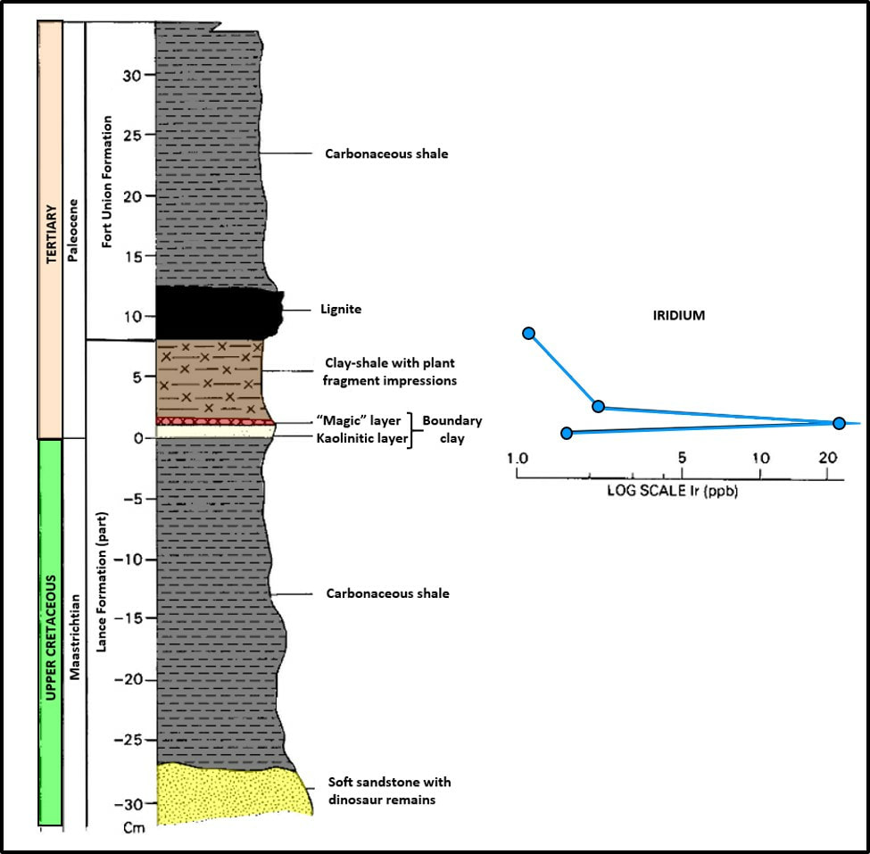
Three sites have recognized the K-T boundary iridium layer in the Powder River Basin. The first to be discovered was the Dogie Creek location about 18 miles north of Lance Creek, in the southeastern Powder River Basin (Bohor, B.F., Triplehorn, D.M., Nichols, D.J., Millard, H.T., Jr., 1987, Dinosaurs, spherules, and the “magic” layer: A new K-T boundary clay site in Wyoming: Geological Society of America Geology, p. 896-899). The site is in the Center, East, Section 5, Township 38 North, Range 65 West, Niobrara County. This site is near the type section for the Lance Formation in an area with well-studied dinosaur and flora assemblages. The boundary layer is characterized by a claystone unit, iridium anomaly, shocked minerals, glass spherules (produced from melted crust falling back through the atmosphere), and a fern-spore spike.
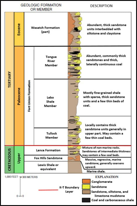
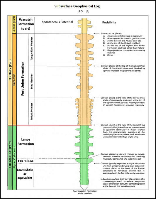
The upper Cretaceous rocks are a complexly interfingered set of marine, coastal and continental deposits through the Lance Formation. The Tertiary is entirely continental deposits, laid down during the Laramide Orogeny. The K-T boundary layer occurs at the top of the terrestrial deposits of the Lance Formation. This often coincides near the base of the first Fort Union coal bed.
The upper Cretaceous rocks are a complexly interfingered set of marine, coastal and continental deposits through the Lance Formation. The Tertiary is entirely continental deposits, laid down during the Laramide Orogeny. The K-T boundary layer occurs at the top of the terrestrial deposits of the Lance Formation. This often coincides near the base of the first Fort Union coal bed.
Outcrop and subsurface sections of the Upper Cretaceous and Lower Tertiary stratigraphic units in the Powder River Basin. K-T Boundary layer is indicated by red line in both columns.
Image: Left: After Hinaman, K.,2005, Hydrogeologic Framework and Estimates of Ground-Water Volumes in Tertiary and Upper Cretaceous Hydrologic Units in the Powder River Basin: U.S. Geological Survey Scientific Investigations Report 2005-5008, Fig. 2, p. 4; https://pubs.usgs.gov/sir/2005/5008/pdf/sir20055008.pdf; Right: After Conner, C.W., 1992, The Lance Formation Petrography and Stratigraphy, Powder River Basin and Nearby Basins, Wyoming and Montana: U.S. Geological Survey Bulletin 1917-I, Fig. 2, p. 14; https://pubs.usgs.gov/bul/1917i/report.pdf.
Image: Left: After Hinaman, K.,2005, Hydrogeologic Framework and Estimates of Ground-Water Volumes in Tertiary and Upper Cretaceous Hydrologic Units in the Powder River Basin: U.S. Geological Survey Scientific Investigations Report 2005-5008, Fig. 2, p. 4; https://pubs.usgs.gov/sir/2005/5008/pdf/sir20055008.pdf; Right: After Conner, C.W., 1992, The Lance Formation Petrography and Stratigraphy, Powder River Basin and Nearby Basins, Wyoming and Montana: U.S. Geological Survey Bulletin 1917-I, Fig. 2, p. 14; https://pubs.usgs.gov/bul/1917i/report.pdf.
The uppermost Cretaceous Lance formation consists of fluvial sandstone, mudstone, claystone, and carbonaceous shale. It is equivalent to the Hell Creek Formation in Montana. The combined thickness of the Lance/Fox Hills in the Powder River Basin is 700 feet in the north and up to 3,300 feet to the south, with little thickness changes from west to east. The basin was subsiding more in the south (and/or over a longer time period) as the Western Interior Seaway withdrew from Wyoming. The Lance was deposited by streams flowing northeastward across a coastal plain along the withdrawing margin of the Western Interior Seaway in easternmost Montana and western North Dakota.
The depositional environments of the Fort Union Formation consist of northeastward flowing braided, meandering and anastomosing streams in the Powder River Basin. Alluvial fans were deposited at the margins of the basin adjacent to the mountain uplifts. Thickness ranges from 2,300 (in the south and east) to 6,000 feet (in the west). The lowermost Paleocene Fort Union Formation consists of carbonaceous shale, variegated mudstone, crevasse-splay sandstone, and numerous coal beds.
The depositional environments of the Fort Union Formation consist of northeastward flowing braided, meandering and anastomosing streams in the Powder River Basin. Alluvial fans were deposited at the margins of the basin adjacent to the mountain uplifts. Thickness ranges from 2,300 (in the south and east) to 6,000 feet (in the west). The lowermost Paleocene Fort Union Formation consists of carbonaceous shale, variegated mudstone, crevasse-splay sandstone, and numerous coal beds.
Stratigraphic column of rock units above and below the boundary clay at Dogie Creek. Iridium anomaly scale to the right showing maximum concentration at 20.8 parts per billion (ppb).
Image: After Bohor, B.F., Triplehorn, D.M., Nichols, D.J., and, Millard, H.T., Jr., 1987, Dinosaurs, spherules, and the "magic“ layer: A new K-T boundary clay site in Wyoming: Geology, Vol. 18, Fig. 3, p. 897.
Image: After Bohor, B.F., Triplehorn, D.M., Nichols, D.J., and, Millard, H.T., Jr., 1987, Dinosaurs, spherules, and the "magic“ layer: A new K-T boundary clay site in Wyoming: Geology, Vol. 18, Fig. 3, p. 897.
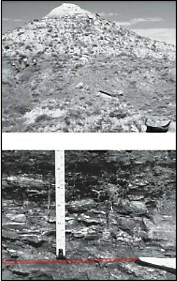
Dogie Creek K-T boundary clay outcrop about 20 miles northwest of Lusk, WY. Top: Paleocene Fort Union Formation overlies the Latest Cretaceous Lance Formation. Bottom: Boundary clay highlighted in red.
Image: After Nichols, D.J., and Johnson, K.R., 2011, Plants and the K-T Boundary, Fig 7.26, Location 1894 in Kindle Version.
Image: After Nichols, D.J., and Johnson, K.R., 2011, Plants and the K-T Boundary, Fig 7.26, Location 1894 in Kindle Version.
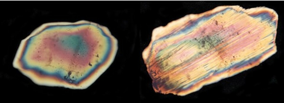
Thin section microscope view of regular quartz (left) and shocked quartz (right). The quartz is put under intense pressure from the impact that deforms the quartz along planes (microfractures) within the mineral.
Image: University of Calgary: Dinosaur Extinction Page, Fig. 7; https://geoscience.ucalgary.ca/tamaratt-chair/historical-case-studies/dinosaur-extinction.
Image: University of Calgary: Dinosaur Extinction Page, Fig. 7; https://geoscience.ucalgary.ca/tamaratt-chair/historical-case-studies/dinosaur-extinction.
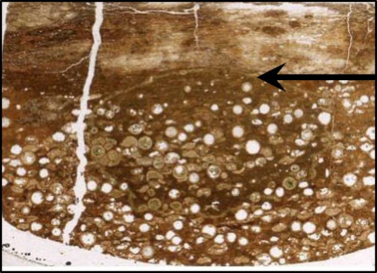
Dogie Creek K-T boundary layer with two intervals. Arrow points to the contact of the two intervals. Lower interval contains hollow, well preserved spherules that have been replaced by goyazite (hydrous strontium aluminum phosphate). Upper interval has a high concentration of iridium and abundant shocked quartz. The K-T boundary layer also contains a fern-spore spike. The K-T boundary layer is a claystone with palynology consisting almost entirely of fern spores (93%) with one species being dominant. This suggests the vegetation in the earliest Tertiary was dominated by a single species of fern. The angiosperm pollen quickly recovers after the impact event. The fern-spike is characteristic of continental K-T boundary sequences in western North America.
Image: https://www.geo.vu.nl/~smit/debates/western.html
Image: https://www.geo.vu.nl/~smit/debates/western.html
Sussex K-T Locality
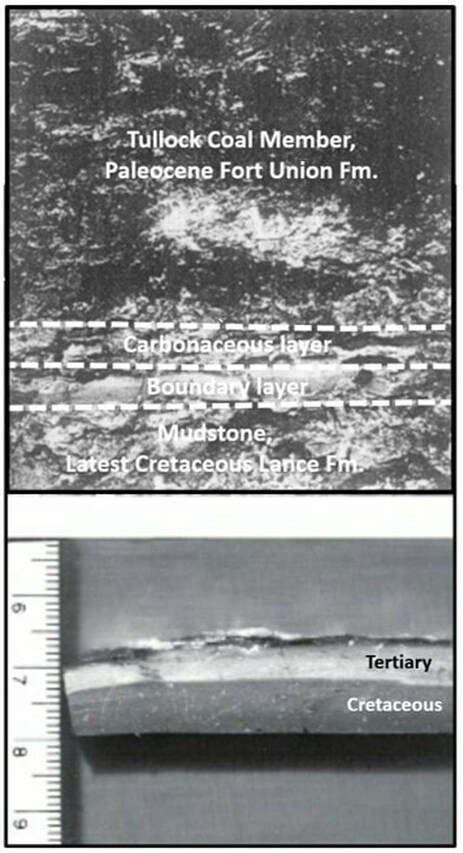
The Sussex locality is about 18 miles north of the abandoned town of Sussex, in the western Powder River Basin (Nichols, D.J., Brown, J.L., Attrep, Jr., and Orth, C.J., 1992a, A new Cretaceous-Tertiary boundary locality in the western Powder River Basin, Wyoming: biological and geological implications: Cretaceous Research 13, No. 1, p. 3-30.). The site is in the Northwest, Northwest, Northwest, Section 14, Township 46 North, Range 79 West, Johnson County. The Lance is about 2,400 feet thick in the Sussex area. Fragments of dinosaur bones are found 20 feet below the boundary layer. The characteristics of the boundary layer are very similar to Dogie Creek but lack the glass goyazite spherules. The locality provided additional data on the effects of the K-T boundary impact on plants. The Sussex locality records detailed identification events at the K-T boundary. They include: 1) deposition of mud or clay in a low-energy overbank setting in a vegetated environment; 2) asteroid impact causing abrupt disruption of the plant ecosystem with extinction of about one-third of the taxa (especially angiosperm species); 3) deposition of fallout debris; 4) revegetation of area, at first dominated by a single species of fern; 5) burial of fallout material by detrital muds with some washed in fallout debris; 6) development of a mire (swampy ground) in revegetated area; 7) accumulation of peat (precursor to coal); 8) burial of mire by fluvial activity; 9) generation of a new plant ecosystem; 10) preservation of stratal package into the geologic record.
K-T boundary layer at the Sussex locality. Top: boundary interval overlain by Tertiary coal and underlain by Cretaceous mudstone in outcrop, Bottom: detail image of boundary claystone. The thin dark layer at the top has the highest concentration of iridium.
Image: Top: after Nichols, D.J., Brown, J.L., Attrep, M., Jr. and Orth, C.J., 1992a, A New Cretaceous-Tertiary boundary locality in the western Powder River Basin, Wyoming: biological, and geological implications: Cretaceous Research 13, No. 1, Fig 3a, p. 9;
Bottom: After Nichols, D.J., and Johnson, K.R., 2011, Plants and the K-T Boundary, Fig 7.28, Location 1923 in Kindle Version
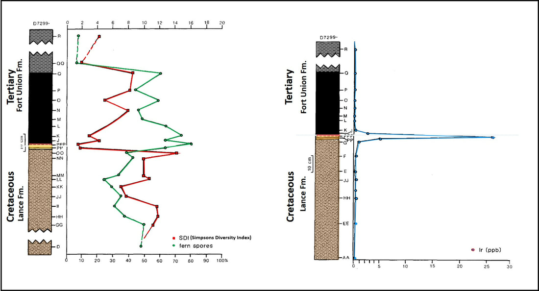
Sussex locality fern-spore spike, diversity index (left), and iridium concentration (right) across the K-T Boundary Layer. The peak iridium anomaly is 26.0 ppb.
Image: After Nichols, D.J., Brown, J.L., Attrep, M., Jr. and Orth, C.J., 1992a, A New Cretaceous-Tertiary boundary locality in the western Powder River Basin, Wyoming: biological, and geological implications: Cretaceous Research 13, No. 1, Fig 6, p. 18 (left), and Fig. 8, p. 23 (right).
Image: After Nichols, D.J., Brown, J.L., Attrep, M., Jr. and Orth, C.J., 1992a, A New Cretaceous-Tertiary boundary locality in the western Powder River Basin, Wyoming: biological, and geological implications: Cretaceous Research 13, No. 1, Fig 6, p. 18 (left), and Fig. 8, p. 23 (right).
Teapot Dome K-T Locality
The Teapot Dome locality is about 12.5 miles east of Teapot Rock, in the southwestern Powder River Basin (Bohor, B.F., Triplehorn, D.M., Nichols, D.J., Millard, H.T., Jr., 1987, Dinosaurs, spherules, and the “magic” layer: A new K-T boundary clay site in Wyoming: Geological Society of America Geology, p. 896-899). The site is in the Northeast, Southeast, Northwest, Section 23, Township 38 North, Range 77 West, Converse County. The boundary characteristics of the locality closely resemble the Dogie Creek site.
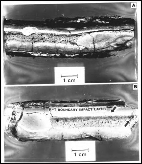
Polished slabs of the Teapot Dome boundary layer. A, Prominent dark layer which contains goyazite spherules, occurs at the top of the K-T boundary claystone bed. First appearance of shocked quartz occurs on top of the goyazite layer. B, Prominent layer of Goyazite-enriched claystone abuts a pellet of kaolinitic claystone that is free of goyazite. Arrows point to the K-T boundary impact layer and a large goyazite crystal.
Image: Izett, G.A., 1987, The Cretaceous-Tertiary (K-T) boundary interval, Raton Basin, Colorado and New Mexico, and its content of shock-metamorphosed minerals: Implications concerning the K-T boundary impact-extinction theory: U.S. Geological Survey Open –File Report 87-606, Fig. 14. p. 43; https://pubs.usgs.gov/of/1987/0606/report.pdf.
Image: Izett, G.A., 1987, The Cretaceous-Tertiary (K-T) boundary interval, Raton Basin, Colorado and New Mexico, and its content of shock-metamorphosed minerals: Implications concerning the K-T boundary impact-extinction theory: U.S. Geological Survey Open –File Report 87-606, Fig. 14. p. 43; https://pubs.usgs.gov/of/1987/0606/report.pdf.
The demise of the dinosaur at the end of the Mesozoic era due to the impact of an extraterrestrial object is one of the amazing stories revealed by science. It demonstrates the consequences of a catastrophic event beyond the control of humans. But the extinction at the end of the Mesozoic was neither the only or the largest such event to occur on the earth. Five major extinctions have occurred in the geologic record. In the Powder River Basin we have three places to see this significant geologic marker.
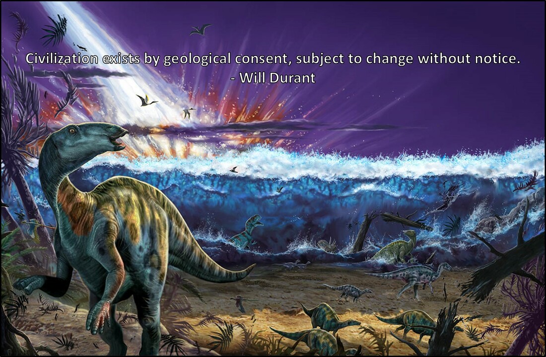
The Chicxulub impact and tsunami.
Image: After Illustration by Franco Tempesta, 2017, National Geographic Education Blog; https://natgeoeducationblog.files.wordpress.com/2017/05/chicxulub-impact1.jpg.
Image: After Illustration by Franco Tempesta, 2017, National Geographic Education Blog; https://natgeoeducationblog.files.wordpress.com/2017/05/chicxulub-impact1.jpg.
HHMI BioInteractive Video has a three-part film for middle school-age students titled “The Day the Mesozoic Died” worth viewing on you tube: https://www.youtube.com/watch?v=tRPu5u_Pizk&feature=youtu.be;
and for download at: https://www.hhmi.org/biointeractive/day-mesozoic-died.
Two Nova programs on the K-T boundary extinction worth watching are:
1) Season 8, Episode 8, “ The Asteroid and the Dinosaur,” First broadcast Mar. 10, 1981; https://www.tvguide.com/tvshows/nova/episode-8-season-8/the-asteroid-and-dinosaur/191695/, and
2) Season 44, Episode 21, “ Day the Dinosaur Died,” First broadcast Dec. 27, 2017; https://www.pbs.org/video/day-the-dinosaurs-died-rooax3/.

The material on this page is copyrighted


