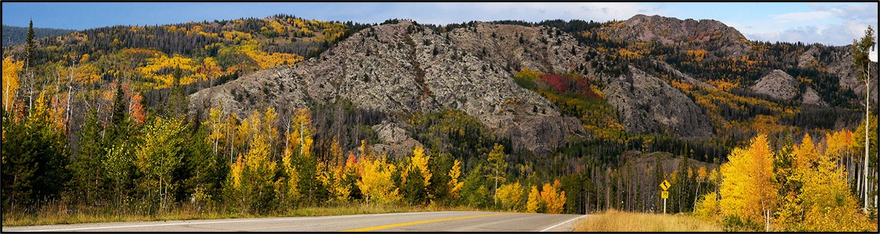
Autumn splendor in the Sierra Madre Range, southern Wyoming.
Image: VIP's Guide to Southern Wyoming;
https://goin2wyo.com/sierra-madre-mountains.html.
Image: VIP's Guide to Southern Wyoming;
https://goin2wyo.com/sierra-madre-mountains.html.
Wow Factor (4 out of 5 stars):

Geologist Factor (3 out of 5 stars):

Attraction
Scenic highway across the Sierra Madre Mountains, Wyoming. Historic mining area and awesome autumn beauty.
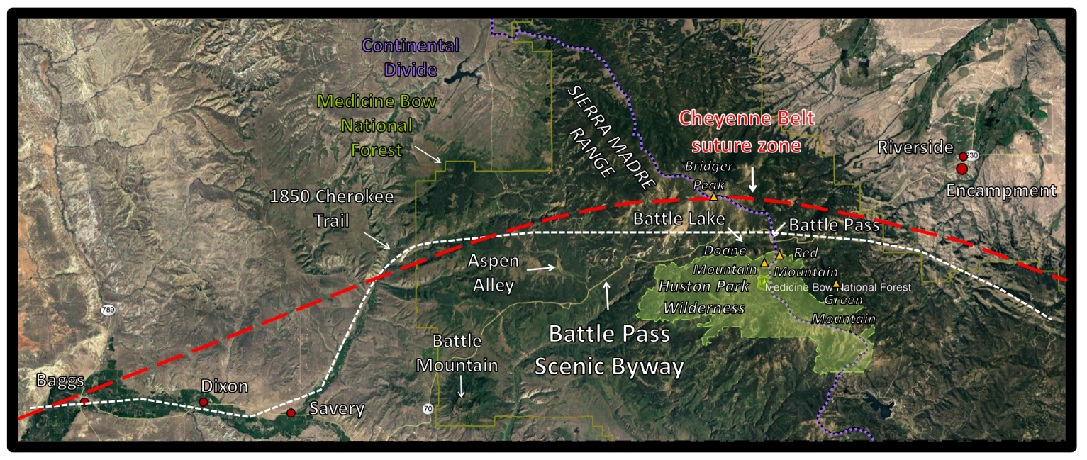
The Sierra Madre Mountains are an underappreciated treasure in southern Wyoming. The mountain range attracts few visitors to enjoy their majesty. The Battle Mountain Byway (WY-70) crosses the range from Encampment to Baggs over the Continental Divide (56-miles).
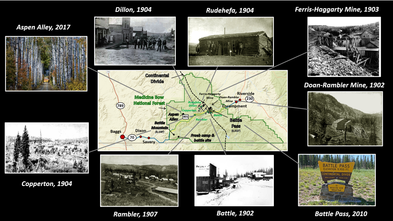
Battle Pass scenic byway, southern Wyoming.
Image: After https://www.wyohistory.org/field-trips/battle-pass-scenic-byway; Battle, Copperton, Dillion, Doan-Rambler Mine, Ferris-Haggerty Mine, Rambler, Rudefeha: http://www.wyomingtalesandtrails.com/; Aspen Alley: https://www.wyomingcarboncounty.com/resources/gallery/1204-aspen-alley-near-saratoga; Battle Pass: Bishop, R., 2010, https://passbagger.org/pb-wy-battle.htm.
Image: After https://www.wyohistory.org/field-trips/battle-pass-scenic-byway; Battle, Copperton, Dillion, Doan-Rambler Mine, Ferris-Haggerty Mine, Rambler, Rudefeha: http://www.wyomingtalesandtrails.com/; Aspen Alley: https://www.wyomingcarboncounty.com/resources/gallery/1204-aspen-alley-near-saratoga; Battle Pass: Bishop, R., 2010, https://passbagger.org/pb-wy-battle.htm.
The portion of Wyoming Highway 70 that lies within the Medicine Bow National Forest (milepost 22-50) was designated a scenic byway in 2012. The 28-mile route of awesome beauty passes several historical sites, that include Battle Pass, mining ghost towns, and Battle Mountain. Battle Pass crosses the Continental Divide at 9,955 foot elevation. The pass is named after a fierce 2-day battle between about 23 fur trappers and 500 to 700 Sioux, Cheyenne, and Arapaho warriors in 1841. Henry Fraeb’s party camp at the confluence of the Little Snake River and Battle Creek was attacked in the shadow of Bastion Mountain 18 miles southwest of the pass. Fraeb was killed early in the battle and 21-year old Jim Baker took command of the trappers. After the largest fight in the Rocky Mountains between Indians and fur trappers, the mountain was renamed Battle Mountain. The name was applied to other places in the Sierra Madre Range, including Battle Pass, Battle Creek, and Battle Lake. Baker built a cabin in the valley near Savery. He is buried in the family cemetery on a hill overlooking the Littles Snake River valley, and within sight of Bakers Peak, and Battle Mountain.

Battle Mountain and valley where Henry Fraeb, a partner of Jim Bridger, and his fur trapping party battled hundreds of Indians, Carbon County, Wyoming.
Image: Bulger, A., 2018, Name That Elk Country: Bugle Magazine, Rocky Mountain Elk Foundation, Fig. on p. 21; http://bugle.rmef.org/publication/?i=471676&p=3
Image: Bulger, A., 2018, Name That Elk Country: Bugle Magazine, Rocky Mountain Elk Foundation, Fig. on p. 21; http://bugle.rmef.org/publication/?i=471676&p=3
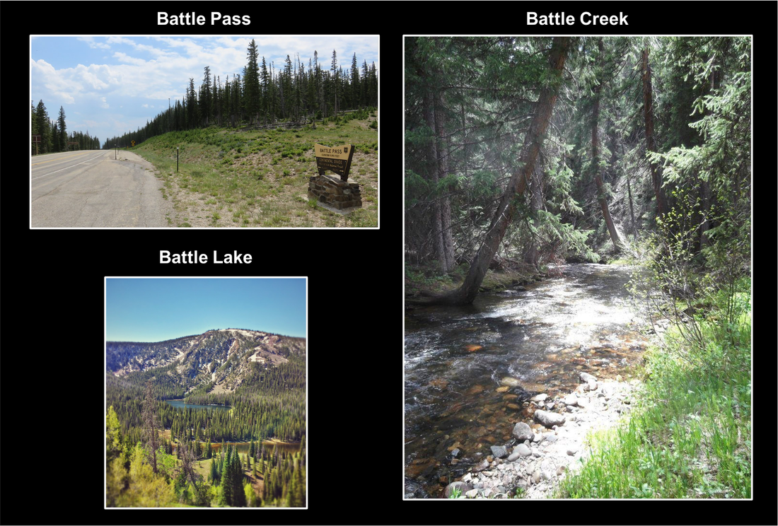
Sites named after the 1841 battle, Sierra Madre Range, Wyoming.
Image: Pass: https://www.flickr.com/photos/courthouselover/43682312280;
Lake: https://lh5.googleusercontent.com/p/AF1QipNLX4ZW0RjilKI4uKOwDuF18jlD6KYPigPRiYJo=h1440;
Creek: https://i.pinimg.com/originals/65/d5/b8/65d5b888f98334e0a578adcde305bd34.jpg.
Image: Pass: https://www.flickr.com/photos/courthouselover/43682312280;
Lake: https://lh5.googleusercontent.com/p/AF1QipNLX4ZW0RjilKI4uKOwDuF18jlD6KYPigPRiYJo=h1440;
Creek: https://i.pinimg.com/originals/65/d5/b8/65d5b888f98334e0a578adcde305bd34.jpg.
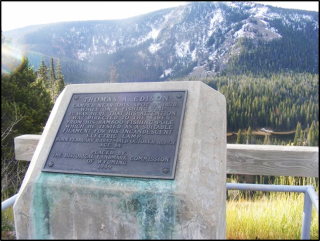
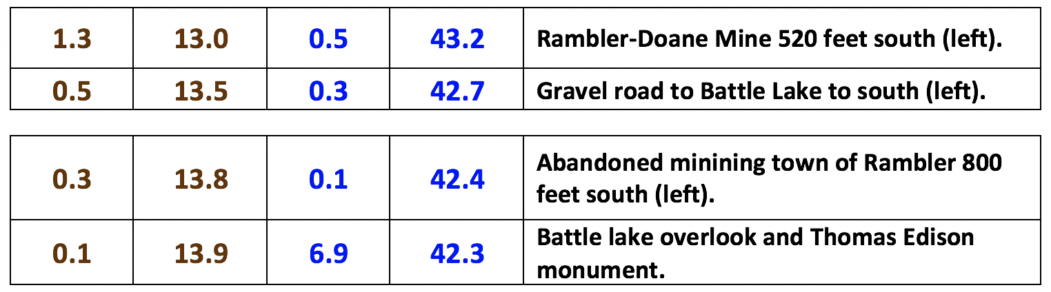
A historical marker near Battle Lake relays a legend about Thomas Edison’s inspiration for the incandescent light (Roberts, P.J., 1981, Edison, the Electric Light, and the Eclipse: Annals of Wyoming, Vol. 53, Np. 1, p. 54-62). The glow from a burning bamboo fishing pole is the reported source of inspiration. The inscription reads:
“Thomas A. Edison camped near this spot in 1878 while on a fishing trip. It was here that his attention was directed to the fiber from his bamboo fishing pole which he tested as a suitable filament for his incandescent electric light. Born February 11, 1847. Died October 18, 1951. Age 84. Placed by the Historical Landmark Commission of Wyoming 1949.”
Edison did eventually test bamboo as a filament, but only after trying about 6,000 other materials. His first success occurred, one year after the 1878 fishing trip, with carbonized cotton thread, not bamboo.
Edison monument, Battle Pass Byway, Sierra Madre Rane, Wyoming.
Image: https://rockymountainhiker.files.wordpress.com/2017/05/2016_12130048.jpg?w=1200&h=.
Image: https://rockymountainhiker.files.wordpress.com/2017/05/2016_12130048.jpg?w=1200&h=.
Geology of Sierra Madre Mountains
Wyoming Highway 70 travels over the basement core of the Sierra Madre Range adjacent to the Cheyenne Belt suture zone. Gold seekers on the way to California, in 1850, traveled along the nearby Southern Cherokee Trail. Copper was discovered in the Sierra Madre Range in the Doane-Rambler area in 1874. After Ed Haggarty’s discovery of a highly weathered iron-rich quartzite rock, called gossan in the Ferris-Haggarty area in 1897, prospectors, miners, and merchants flooded into new mines and towns in the area (see Encampment Geowyo site). Gossan is a highly weathered rock that is evidence of a sulfide ore deposit.
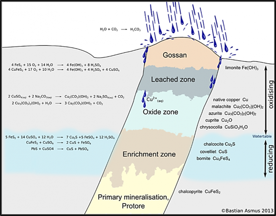
Schematic view of sulfide vein and weathered gossan at surface.
Image: Ozdemir, A, and Sahinoglu, A., 2018, Important of Gossans in Mineral Exploration: A Case Study in Northern Turkey, Int J Earth Sci Geophys 4:019, Fig. 5, p. 6; https://www.researchgate.net/publication/327415268_Important_of_Gossans_in_Mineral_Exploration_A_Case_Study_in_Northern_Turkey/link/5b94ad784585153a530e490c/download
Image: Ozdemir, A, and Sahinoglu, A., 2018, Important of Gossans in Mineral Exploration: A Case Study in Northern Turkey, Int J Earth Sci Geophys 4:019, Fig. 5, p. 6; https://www.researchgate.net/publication/327415268_Important_of_Gossans_in_Mineral_Exploration_A_Case_Study_in_Northern_Turkey/link/5b94ad784585153a530e490c/download
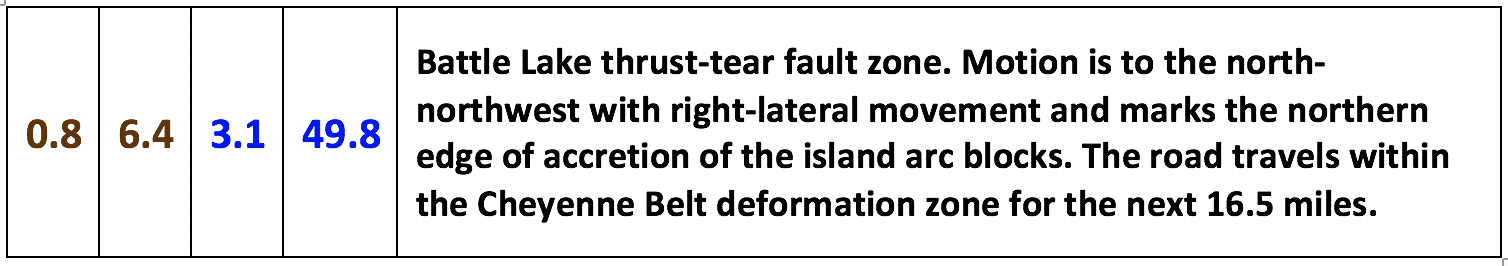
The Sierra Madre Mountains are a northwest-southeast oriented basement arch elevated by the Laramide Orogeny (70-56 Ma). The Range exposes an ancient suture zone in the basement. The northeast-trending Cheyenne Belt is a zone of deformation separating the Proterozoic Colorado Province (Mojave, Green Mountain, and Yavapai blocks) from the Archean Wyoming Province. The older granites, gneisses, and enfolded metasedimentary rocks north of the belt contrast sharply with the younger metavolcanic, metagraywacke, and deeper water rocks of the volcanic island terrane to the south. The suture zone is two to three miles wide and about 125 miles in length. The Cheyenne Belt was created by a continent-island arc tectonic plate collision that occurred between 1.8 and 1.6 billion years ago.
The Continental Dynamics of the Rockies (CD-ROM) Working Group has interpreted data across the Cheyenne Belt as a major tectonic crustal boundary in the Rockies. The record of accretion and growth of this part of the North American continent is preserved in the faults, deformation, and metamorphism observed within the basement rock.
The Continental Dynamics of the Rockies (CD-ROM) Working Group has interpreted data across the Cheyenne Belt as a major tectonic crustal boundary in the Rockies. The record of accretion and growth of this part of the North American continent is preserved in the faults, deformation, and metamorphism observed within the basement rock.
Aerial view of Wyoming Highway 70 area geologic map below.
Image: Google Earth
Image: Google Earth
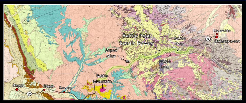
Geologic map of Wyoming Highway 70 area.
Image: Top left and middle: Scott, J.E., Sutherland, W.M., Johnson, J., and McLaughlin, J.F., 2011, Geologic Map of the Baggs 30' x 60' Quadrangle, Carbon and Sweetwater Counties, Wyoming, and Moffat and Routt Counties, Colorado: Wyoming State Geological Survey, Map Series 95, scale 1:100,000; https://ngmdb.usgs.gov/ngm-bin/pdp/zui_viewer.pl?id=56625; Top right & bottom: Sutherland, W.M., and Hausel, W.D., 2005, Preliminary geologic map of the Saratoga 30' x 60' quadrangle, Carbon and Albany Counties, Wyoming, and northern Colorado: Wyoming State Geological Survey, Open File Report OFR 04-10, scale 1:100,000; https://ngmdb.usgs.gov/ngm-bin/pdp/zui_viewer.pl?id=21622.
Image: Top left and middle: Scott, J.E., Sutherland, W.M., Johnson, J., and McLaughlin, J.F., 2011, Geologic Map of the Baggs 30' x 60' Quadrangle, Carbon and Sweetwater Counties, Wyoming, and Moffat and Routt Counties, Colorado: Wyoming State Geological Survey, Map Series 95, scale 1:100,000; https://ngmdb.usgs.gov/ngm-bin/pdp/zui_viewer.pl?id=56625; Top right & bottom: Sutherland, W.M., and Hausel, W.D., 2005, Preliminary geologic map of the Saratoga 30' x 60' quadrangle, Carbon and Albany Counties, Wyoming, and northern Colorado: Wyoming State Geological Survey, Open File Report OFR 04-10, scale 1:100,000; https://ngmdb.usgs.gov/ngm-bin/pdp/zui_viewer.pl?id=21622.

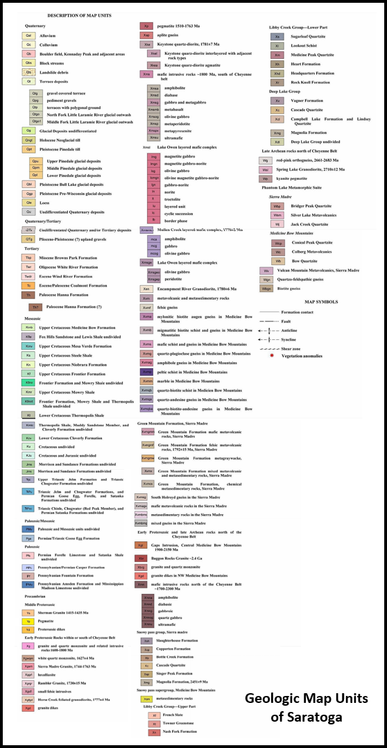
Geologic Map units for Baggs (top) and Saratoga (bottom) maps.
Image: Top left and middle: Scott, J.E., Sutherland, W.M., Johnson, J., and McLaughlin, J.F., 2011, Geologic Map of the Baggs 30' x 60' Quadrangle, Carbon and Sweetwater Counties, Wyoming, and Moffat and Routt Counties, Colorado: Wyoming State Geological Survey, Map Series 95, scale 1:100,000; https://ngmdb.usgs.gov/ngm-bin/pdp/zui_viewer.pl?id=56625; Top right & bottom: Sutherland, W.M., and Hausel, W.D., 2005, Preliminary geologic map of the Saratoga 30' x 60' quadrangle, Carbon and Albany Counties, Wyoming, and northern Colorado: Wyoming State Geological Survey, Open File Report OFR 04-10, scale 1:100,000; https://ngmdb.usgs.gov/ngm-bin/pdp/zui_viewer.pl?id=21622.
Image: Top left and middle: Scott, J.E., Sutherland, W.M., Johnson, J., and McLaughlin, J.F., 2011, Geologic Map of the Baggs 30' x 60' Quadrangle, Carbon and Sweetwater Counties, Wyoming, and Moffat and Routt Counties, Colorado: Wyoming State Geological Survey, Map Series 95, scale 1:100,000; https://ngmdb.usgs.gov/ngm-bin/pdp/zui_viewer.pl?id=56625; Top right & bottom: Sutherland, W.M., and Hausel, W.D., 2005, Preliminary geologic map of the Saratoga 30' x 60' quadrangle, Carbon and Albany Counties, Wyoming, and northern Colorado: Wyoming State Geological Survey, Open File Report OFR 04-10, scale 1:100,000; https://ngmdb.usgs.gov/ngm-bin/pdp/zui_viewer.pl?id=21622.
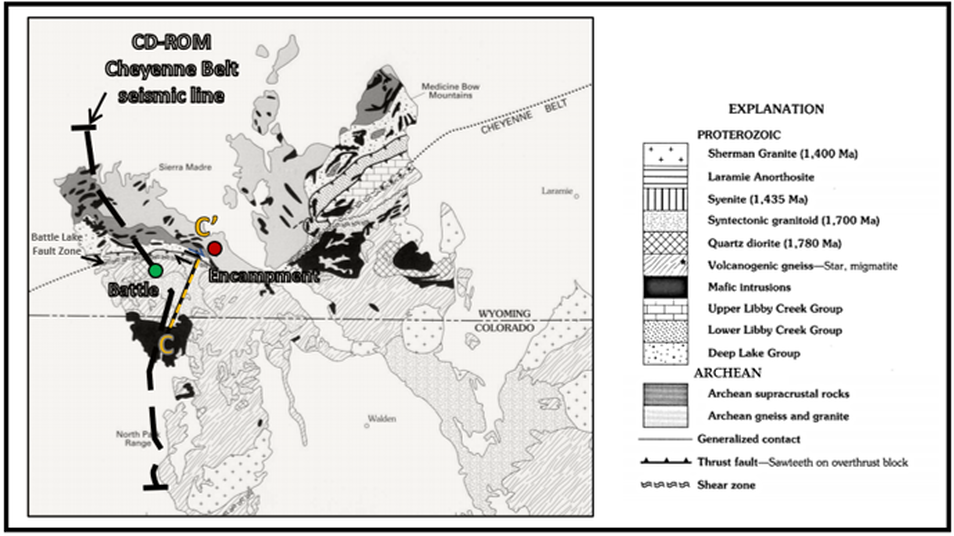
Geology map of Sierra Madre Mountains, Medicine Bow Mountains, and Cheyenne Belt with Continental Dynamics of the Rocky Mountains (CD-ROM) seismic line location. Location dots: Battle, green; Encampment, red. Location of structural cross section CC’ seen a couple of pages lower.
Image: After Houston, R.S. and Marlatt, G., 1997, Proterozoic Geology of Granite Village Area, Albany and Laramie Counties, Wyoming, Compared with That of the Sierra Madre and Medicine Bow Mountains of Southeastern Wyoming: U.S. Geological Survey Bulletin 2159, Fig. 1, p. 2-3; https://digital.library.unt.edu/ark:/67531/metadc958050/m2/1/high_res_d/metadc958050.pdf
Image: After Houston, R.S. and Marlatt, G., 1997, Proterozoic Geology of Granite Village Area, Albany and Laramie Counties, Wyoming, Compared with That of the Sierra Madre and Medicine Bow Mountains of Southeastern Wyoming: U.S. Geological Survey Bulletin 2159, Fig. 1, p. 2-3; https://digital.library.unt.edu/ark:/67531/metadc958050/m2/1/high_res_d/metadc958050.pdf
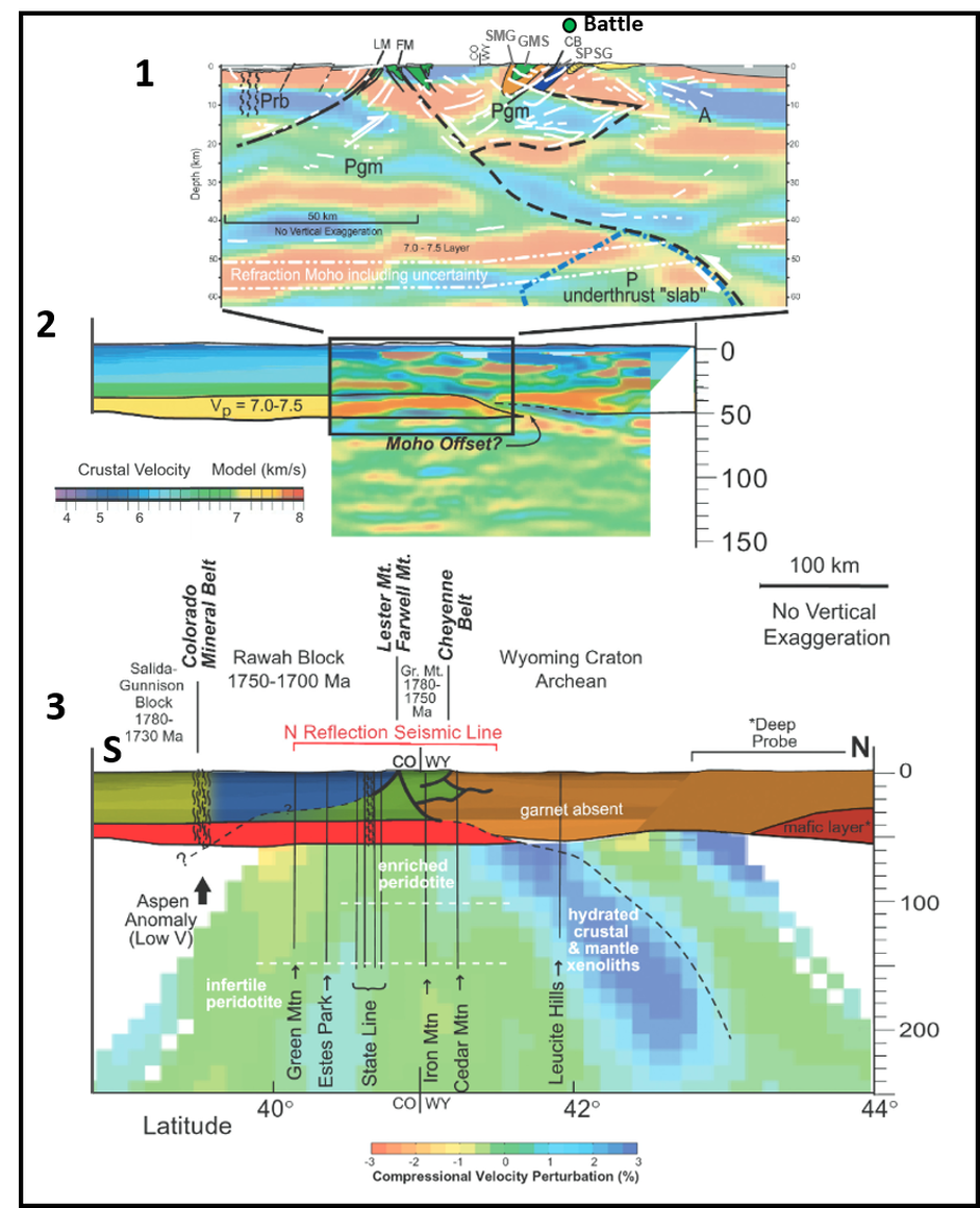
Synthesis of Continental Dynamics of the Rocky Mountains (CD-ROM) results (1) Line drawing of CD-ROM Cheyenne belt seismic reflection line (Morozova et al., 2002) superimposed on receiver function image of Dueker et al. (2001); dashed blue line represents high-velocity body imaged by tomography (2% contour). A—Archean lithosphere; P—Proterozoic lithosphere; Pgm—Proterozoic Green Mountain block; Prb—Proterozoic Rawah block; CB—Cheyenne belt; FM—Farwell Mountain zone; LM—Lester Mountain zone; GMS—Green Mountain syncline; SMG—Sierra Madre granite; SPSG—Snowy Pass Supergroup. (2) Results from CD-ROM refraction experiment; interfaces at Moho and top of 7.0–7.5 km/s layer (about 15,500-16,750 mph) are well resolved by wide-angle reflections and refractions (Rumpel et al., 2001; Snelson, 2001); receiver function images (Dueker et al., 2001) are superimposed on refraction model and show good agreement for mafic lower crustal layer. (3) Generalized geologic cross section superimposed on P-wave tomographic image of Dueker et al. (2001). Crustal structures in Cheyenne belt lineament area are generalized from seismic reflection data (above) with solid lines representing well-defined reflections. Locations of xenolith pipes shown as vertical lines. Dipping elements in tomographic image, combined with overlying crustal structures, are interpreted to be Proterozoic suture zones and North American lithosphere is interpreted to extend to greater than 125 mile depth (200 km).
Image: After CD-ROM Working Group,2002, Structure and Evolution of the Lithosphere Beneath the Rocky Mountains: Initial Results from the CD-ROM Experiment: GSA Today, Fig. 2, p. 6-7; https://www.geosociety.org/gsatoday/archive/12/3/pdf/i1052-5173-12-3-4.pdf
Image: After CD-ROM Working Group,2002, Structure and Evolution of the Lithosphere Beneath the Rocky Mountains: Initial Results from the CD-ROM Experiment: GSA Today, Fig. 2, p. 6-7; https://www.geosociety.org/gsatoday/archive/12/3/pdf/i1052-5173-12-3-4.pdf
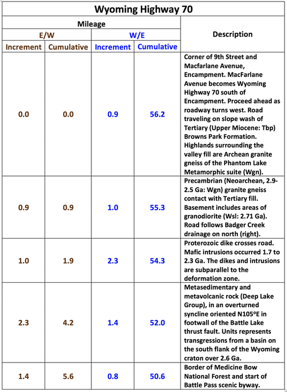
Geology Road Log of Wyoming 70 from Encampment to Baggs
Road log is constructed using Google Earth and the Wyoming State Geological Survey Baggs and Saratoga 30 x 60 Quadrangle geologic maps.

Wyoming Highway 70 elevation profile.
Image: After Google Earth.
Image: After Google Earth.
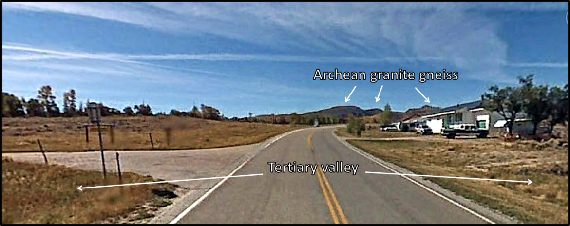
Start of road log at southern end of Encampment in valley of the Encampment River.
Image: Google Earth Street View
Image: Google Earth Street View
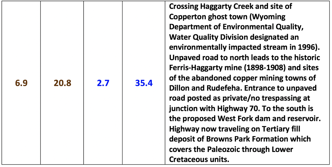
The Ferris Haggerty Mine was the most productive copper mine in the district. The mine was opened as the Rudefeha mine in 1897 at se/4 ne/4, Section 16, Township 14 North, Range 86 West. The mine was about 16 miles west of Encampment on the west side of the Continental Divide at an altitude of 9,888 feet. The ore was hauled 60 miles by wagon to the nearest Union Pacific rail junction then shipped to a smelter in Chicago. The ore is hosted by the Magnolia Quartzite Member of the lower part of the Deep Lake Formation. A 20 foot copper vein lies in a brecciated quartzite that is in contact with a hanging wall schist. The ore bed dips 30 to 60 degrees south and is 250 to 300 feet long. The mine closed in 1908 but the ore was not played out. The Ferris-Haggerty Mining Corporation of Colorado purchased the abandoned mine in 2015 with plans to renew operations. The company estimated the mine contains up to 95 percent of the original copper in place (928,500 tons) with 116,000 ounces of gold in reserve.

Highway signs for Medicine Bow National Forest and Battle Pass Scenic Byway.
Image: Left: https://www.wyomingpublicmedia.org/post/medicine-bow-routt-national-forest-concerned-about-fire-outbreak#stream/0;
Right: https://www.pinterest.com/pin/392587292508775943/.
Image: Left: https://www.wyomingpublicmedia.org/post/medicine-bow-routt-national-forest-concerned-about-fire-outbreak#stream/0;
Right: https://www.pinterest.com/pin/392587292508775943/.
Structural cross section CC’ over Sierra Madre Mountains. Geologic notation: Late Archean rocks: Wbp = Bridger Peak quartzite; Wgn = Quartzo-feldspathic gneiss; Ws = Silver Lake metavolcanics; Spring Lake granodiorite; Wv = Vulcan Mountain metavolcanics.; Early Proterozoic and Late Archean rocks: XWd = Mafic diabase intrusive; Proterozoic rocks: Xc = Cascade quartzite; Xcp = Copperton metasedimentary; Xgb = Mafic gabbro intrusive; Xgmf = Green Mountain felsic metavolcanic; Xgmm = Green Mountain mafic metavolcanic; Xgms = Green Mountain chemical metasedimentary; Xgmw = Green Mountain metagraywacke; Xgmx = Green Mountain mixed metavolcanic and metasedimentary; Xsh = Slaughterhouse metasedimentary; Xsm = Sierra Madre granite.
Image: After Houston, R.S., and Graff, P.J., 1995, Geologic map of Precambrian rocks of the Sierra Madre, Carbon County, Wyoming, and Jackson and Routt Counties, Colorado: U.S. Geological Survey Miscellaneous Investigations Series Map I-2452, 1:50,000; https://ngmdb.usgs.gov/Prodesc/proddesc_10283.htm.
Image: After Houston, R.S., and Graff, P.J., 1995, Geologic map of Precambrian rocks of the Sierra Madre, Carbon County, Wyoming, and Jackson and Routt Counties, Colorado: U.S. Geological Survey Miscellaneous Investigations Series Map I-2452, 1:50,000; https://ngmdb.usgs.gov/Prodesc/proddesc_10283.htm.
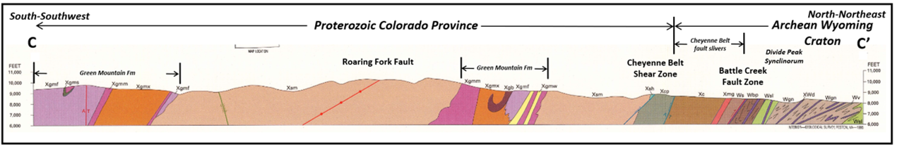
Schematic block diagram showing upper plate (top) and lower plate (bottom) of the Battle Lake Thrust-tear fault system. Upper plate moved north-northwestward, overriding the ductile shear zone that constitutes the western extension of the Cheyenne Belt. Slices of the original Cheyenne Belt mylonites (flatten mineral, fine-grained metamorphic rock created by severe tectonic stress) that have been dismembered and transported north-northwest by the Battle Lake fault system are shown in black in the upper diagram.
Image: After Duebendorfer, E.M., Chamberlain, K.R., and Heizler, M.T., 2006, Filling the North American Proterozoic Tectonic Gap: 1.60–1.59‐Ga Deformation and Orogenesis in Southern Wyoming, USA: The Journal of Geology, Vol. 114, No. 1, Fig. 2, p. 22.
Image: After Duebendorfer, E.M., Chamberlain, K.R., and Heizler, M.T., 2006, Filling the North American Proterozoic Tectonic Gap: 1.60–1.59‐Ga Deformation and Orogenesis in Southern Wyoming, USA: The Journal of Geology, Vol. 114, No. 1, Fig. 2, p. 22.

West aerial view above Battle Pass. Abandoned mining towns are green dots.
Image: Google Earth.
Image: Google Earth.
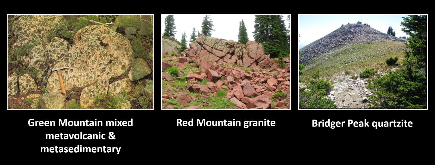
Left: The Paleoproterozoic mixed meta volcanic and meta sedimentary Green Mountain Formation (Xgmx or Xgx, 1.6-1.8 Ga). Middle: The Paleoproterozoic Sierra Madre granite that gives Red Mountain its name (Xgs, 1.74-1.76 Ga). Both units are located south of the Cheyenne Belt. Right: Frost shattered boulder field (felsenmeer) of Neoarchean quartzite at Bridger Peak, north of the Cheyenne Belt suture zone (Wbp, 2.68 Ga).
Image: Left: US Geological Survey I-2452 Geologic map of Precambrian rocks of the Sierra Madre, Carbon County, Wyoming, and Jackson and Routt counties, Colorado, scale 1:62,500, 1995; https://ngmdb.usgs.gov/Prodesc/proddesc_10283.htm;
Center: Scott, 2012, SummitPost; https://www.summitpost.org/red-granite/807549/c-807546;
Right: Scott, 2012, SummitPost; https://www.summitpost.org/bridger-peak/154717.
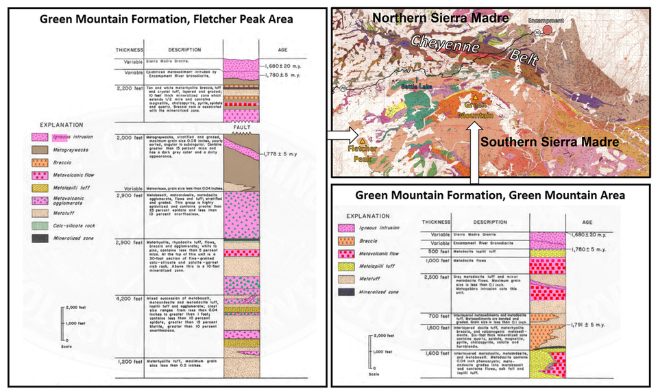
Green Mountain Formation lithology in the southern Sierra Madre Mountains
Image: Rock columns after Schmidt, T., 1983, Metavolcanic rocks and associated volcanogenic mineral deposits of the Flethcher park and Green Mountain areas, Sierra Madre, Wyoming, in Roberts, S., Metallic and Nonmetallic Deposits of Wyoming and Adjacent Areas, 1983 Conference Proceedings, Fig 2, p. 25 and Fig.4, p. 28; https://www.wsgs.wyo.gov/products/wsgs-1986-pic-25.pdf. Map After Houston, R.S., and Graff, P.J., 1995, Geologic map of Precambrian rocks of the Sierra Madre, Carbon County, Wyoming, and Jackson and Routt Counties, Colorado: U.S. Geological Survey Miscellaneous Investigations Series Map I-2452, 1:50,000; https://ngmdb.usgs.gov/Prodesc/proddesc_10283.htm.
Image: Rock columns after Schmidt, T., 1983, Metavolcanic rocks and associated volcanogenic mineral deposits of the Flethcher park and Green Mountain areas, Sierra Madre, Wyoming, in Roberts, S., Metallic and Nonmetallic Deposits of Wyoming and Adjacent Areas, 1983 Conference Proceedings, Fig 2, p. 25 and Fig.4, p. 28; https://www.wsgs.wyo.gov/products/wsgs-1986-pic-25.pdf. Map After Houston, R.S., and Graff, P.J., 1995, Geologic map of Precambrian rocks of the Sierra Madre, Carbon County, Wyoming, and Jackson and Routt Counties, Colorado: U.S. Geological Survey Miscellaneous Investigations Series Map I-2452, 1:50,000; https://ngmdb.usgs.gov/Prodesc/proddesc_10283.htm.
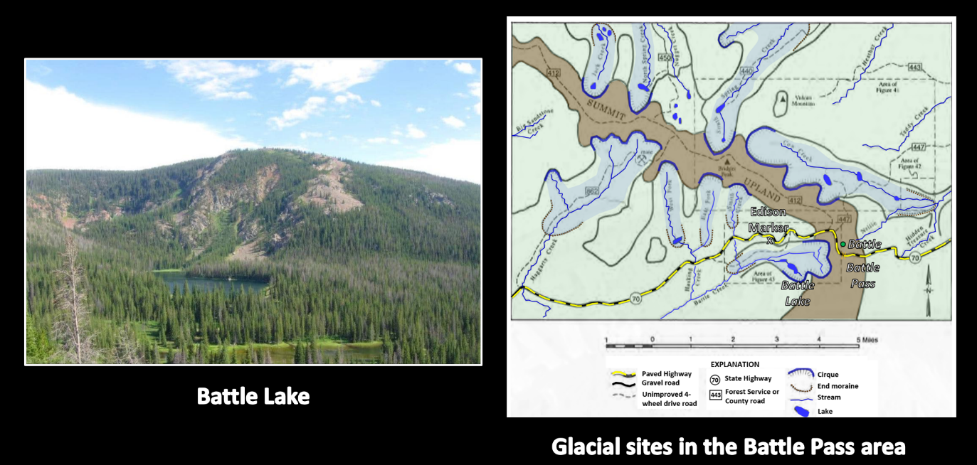
Left: Southeast view of Battle Lake at the Edison Monument site. The lake is located on a north facing cirque on Red Mountain impounded by Pinedale moraine.
Right: Glaciated area of Central Sierra Madre Range, showing unglaciated summit upland of Continental Divide.
Image: Left: Scott, 2012, SummitPost; https://www.summitpost.org/red-mountain/807547/c-807546; Right: Mears, B., Jr, 2001, Glacial records in the Medicine Bow Mountains and Sierra Madre of southern Wyoming and adjacent Colorado: Wyoming State Geological Survey Public Information Circular No. 41, Fig. 40, p. 20; https://mountainscholar.org/bitstream/handle/20.500.11919/5190/wsgs-2001-pic-41.pdf?sequence=1.
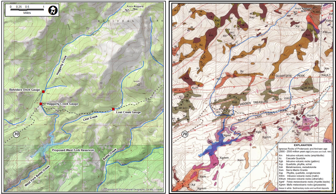
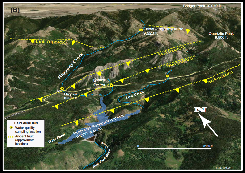
Top: Topographic and geologic maps of proposed West Fork Dam and Reservoir area. Bottom: Aerial perspective view of proposed West Fork Dam and Reservoir project with fault traces.
Image: After Anderson, V.E., 2017, Little Snake River Supplemental Storage Level II Phase II Study Report: WENCK File #2822-03; http://library.wrds.uwyo.edu/wwdcrept/Little_Snake/Little_Snake-Storage_Level_II_Phase_II-Final_Report-2017.pdf.
Image: After Anderson, V.E., 2017, Little Snake River Supplemental Storage Level II Phase II Study Report: WENCK File #2822-03; http://library.wrds.uwyo.edu/wwdcrept/Little_Snake/Little_Snake-Storage_Level_II_Phase_II-Final_Report-2017.pdf.
The proposed West Fork Battle Creek dam project is in a canyon near the confluence of Haggarty and Lost Creeks. The 280-foot dam will contain an 8,500 to 10,000 acre-feet capacity reservoir. Bedrock in the area is comprised of Precambrian metasedimentary and metavolcanic units of the Proterozoic Green Mountain formation. Structurally, the site lies within the complex fault splays of the Cheyenne Belt suture zone.
Runoff from the Ferris Haggarty mine waste is the primary source of metal contamination. Copper ore was mined from a Late Archean quartzite in contact with a schist in the hanging wall of a thrust fault. The major ore types were chalcopyrite and chalcocite, with other copper minerals.
Runoff from the Ferris Haggarty mine waste is the primary source of metal contamination. Copper ore was mined from a Late Archean quartzite in contact with a schist in the hanging wall of a thrust fault. The major ore types were chalcopyrite and chalcocite, with other copper minerals.

Left: Copper ore, Ferris-Haggarty mine; Right: precipitate in mine runoff channel, Osceola Tunnel portal, Ferris-Haggarty mine.
Image: Left: Hausel, D., 2010, Ferris-Haggarty Copper-Gold mine, Encampment District, Wyoming; http://ferris-haggarty.blogspot.com/2010/08/ferris-haggarty-copper-gold-mine-grand.html;
Right: Anderson, V.E., 2017, Little Snake River Supplemental Storage Level II Phase II Study Report: WENCK File #2822-03; http://library.wrds.uwyo.edu/wwdcrept/Little_Snake/Little_Snake-Storage_Level_II_Phase_II-Final_Report-2017.pdf.
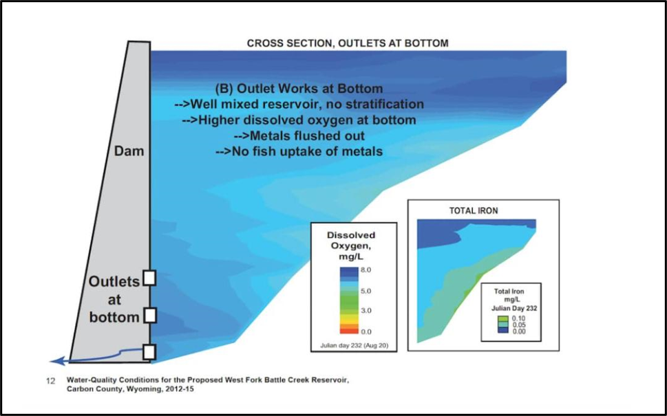
Proposed West Fork dam bottom gate structure design to flush metal out of reservoir.
Image: Anderson, V.E., 2017, Little Snake River Supplemental Storage Level II Phase II Study Report, Appendix A, p. 12; http://library.wrds.uwyo.edu/wwdcrept/Little_Snake/Little_Snake-Storage_Level_II_Phase_II-Final_Report-2017.html.
Image: Anderson, V.E., 2017, Little Snake River Supplemental Storage Level II Phase II Study Report, Appendix A, p. 12; http://library.wrds.uwyo.edu/wwdcrept/Little_Snake/Little_Snake-Storage_Level_II_Phase_II-Final_Report-2017.html.

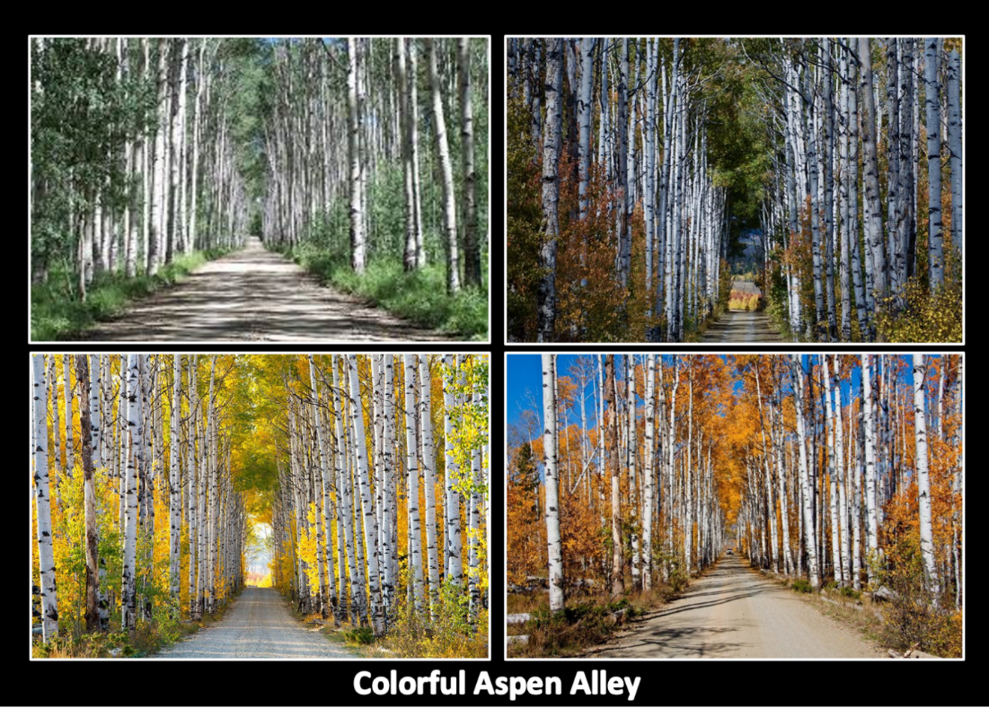
Aspen Alley along Forest Service Road 801.
Image Upper Left: https://www.onlyinyourstate.com/wyoming/a-magical-wy-tunnel-of-trees/; Upper Right: https://greatamericanwest.co/autumn-in-wyoming-aspen-alley-bugling-elk-in-yellowstone-grand-teton-national-parks-fly-fishing/; Lower Left: https://www.pinterest.com/pin/197595502372961518/; Lower Right:
https://cowboystatedaily.com/2020/03/24/welcome-carbon-county-visitor-council-folks-its-time-to-get-your-west-on/.
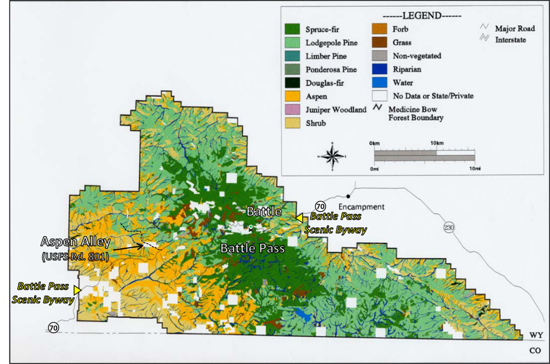
Forest cover in the Medicine Bow National Forest, Sierra Madre Range, Wyoming. Aspen occupy 20% of area predominately on the western flank of the range. Lodgepole pine (51%), Engelmann spruce and subalpine fir (27%) dominate the forest at middle to high elevations (7,290 to 9,900 feet).
Image: After Dillon, G.K., Knight, D.H., and Meyer, C.B., 2000, Historic Variability for Upland Vegetation in the Medicine Bow National Forest, Wyoming: USDA Forest Service - General Technical Report RMRS-GTR 139, Fig. 5b, p. 12; https://www.researchgate.net/publication/267256340_Historic_Variability_for_Upland_Vegetation_in_the_Medicine_Bow_National_Forest_Wyoming
Image: After Dillon, G.K., Knight, D.H., and Meyer, C.B., 2000, Historic Variability for Upland Vegetation in the Medicine Bow National Forest, Wyoming: USDA Forest Service - General Technical Report RMRS-GTR 139, Fig. 5b, p. 12; https://www.researchgate.net/publication/267256340_Historic_Variability_for_Upland_Vegetation_in_the_Medicine_Bow_National_Forest_Wyoming
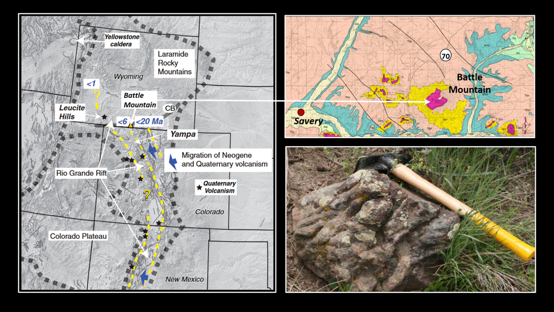
Left: Regional age limits and migration of Neogene to Quaternary volcanism within the northern Rio Grande rift projected onto a digital elevation map with faults (gray lines) indicating Neogene motion. Yellow dashed lines are eastern limits of active volcanism since 20 Ma (Miocene). The present position of the northernmost Rio Grande rift is limited to the region west of the 6 Ma age Limit and includes the Leucite Hills, Wyoming. CB is the approximate position of the Cheyenne belt. Battle Mountain volcanic rocks are dated between 11.6 and 8.7 Ma. Top Right: Battle Mountain geologic map. Bottom Right: Pahoehoe (ropey-like) lava flow from colluvium on west side of Battle Mountain.
Image: Left: After Cosca, M.A., Thompson, R.A. , Lee, J.P. , Turner K.J., Neymark, L.A., and Premo, W.R., 2014, 40Ar/39Ar geochronology, isotope geochemistry (Sr, Nd, Pb), and petrology of alkaline lavas near Yampa, Colorado: Migration of alkaline volcanism and evolution of the northern Rio Grande rift , Geological Society of America Geosphere Vol., 10, No. 2, Fig. 16, p. 397; https://pubs.geoscienceworld.org/gsa/geosphere/article/10/2/374/132148/40Ar-39Ar-geochronology-isotope-geochemistry-Sr-Nd. Top & Bottom Right: After Scott, J.E., Sutherland, W.M., Johnson, J., and McLaughlin, J.F., 2011, Geologic Map of the Baggs 30' x 60' Quadrangle, Carbon and Sweetwater Counties, Wyoming, and Moffat and Routt Counties, Colorado: Wyoming State Geological Survey, Map Series 95, scale 1:100,000; https://www.wsgs.wyo.gov/products/wsgs-2011-ms-95.pdf
Image: Left: After Cosca, M.A., Thompson, R.A. , Lee, J.P. , Turner K.J., Neymark, L.A., and Premo, W.R., 2014, 40Ar/39Ar geochronology, isotope geochemistry (Sr, Nd, Pb), and petrology of alkaline lavas near Yampa, Colorado: Migration of alkaline volcanism and evolution of the northern Rio Grande rift , Geological Society of America Geosphere Vol., 10, No. 2, Fig. 16, p. 397; https://pubs.geoscienceworld.org/gsa/geosphere/article/10/2/374/132148/40Ar-39Ar-geochronology-isotope-geochemistry-Sr-Nd. Top & Bottom Right: After Scott, J.E., Sutherland, W.M., Johnson, J., and McLaughlin, J.F., 2011, Geologic Map of the Baggs 30' x 60' Quadrangle, Carbon and Sweetwater Counties, Wyoming, and Moffat and Routt Counties, Colorado: Wyoming State Geological Survey, Map Series 95, scale 1:100,000; https://www.wsgs.wyo.gov/products/wsgs-2011-ms-95.pdf
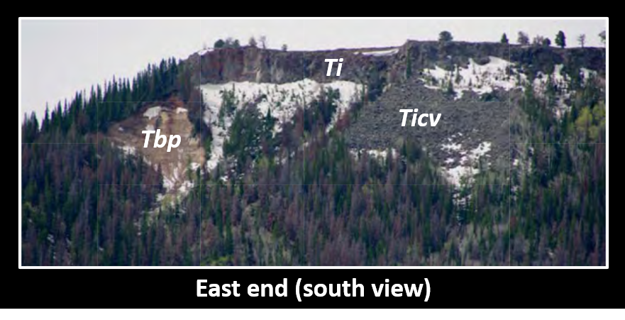
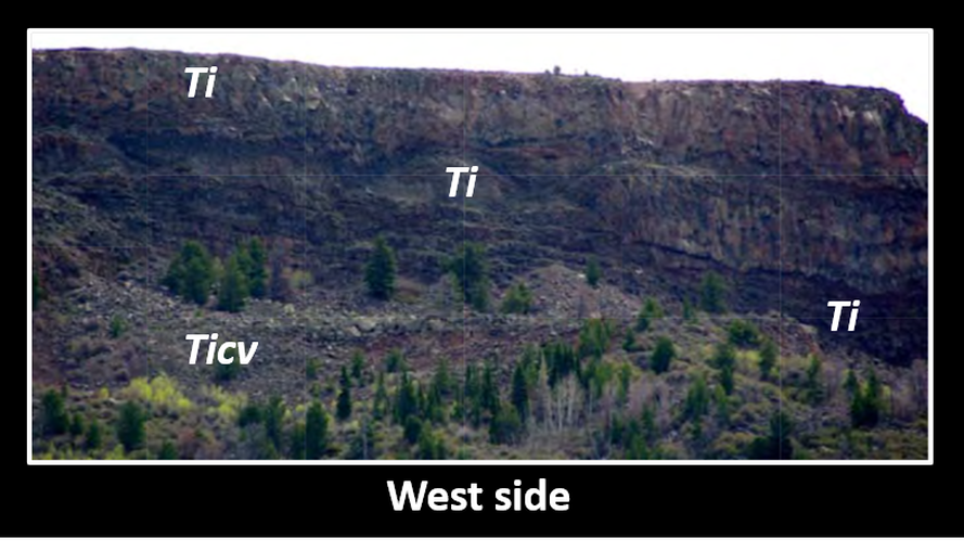
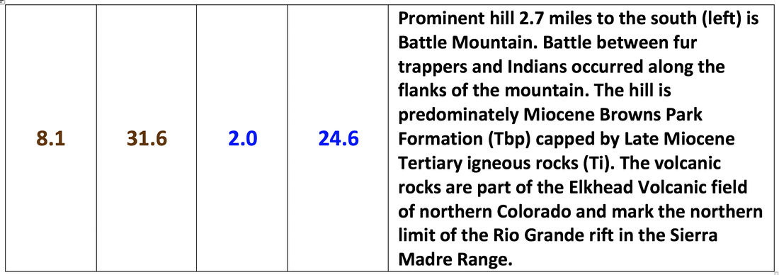
Top: East side of Battle Mountain with lava flows on top (Ti), Browns Park formation (Tbp) on left, and colluvium derived from igneous rocks (Ticv) at right above trees. Bottom: West side of Battle Mountain with multiple lava flows displayed. Lower slopes covered with igneous derived colluvium.
Image: After Scott, J.E., Sutherland, W.M., Johnson, J., and McLaughlin, J.F., 2011, Geologic Map of the Baggs 30' x 60' Quadrangle, Carbon and Sweetwater Counties, Wyoming, and Moffat and Routt Counties, Colorado: Wyoming State Geological Survey, Map Series 95, scale 1:100,000; https://www.wsgs.wyo.gov/products/wsgs-2011-ms-95.pdf
Image: After Scott, J.E., Sutherland, W.M., Johnson, J., and McLaughlin, J.F., 2011, Geologic Map of the Baggs 30' x 60' Quadrangle, Carbon and Sweetwater Counties, Wyoming, and Moffat and Routt Counties, Colorado: Wyoming State Geological Survey, Map Series 95, scale 1:100,000; https://www.wsgs.wyo.gov/products/wsgs-2011-ms-95.pdf

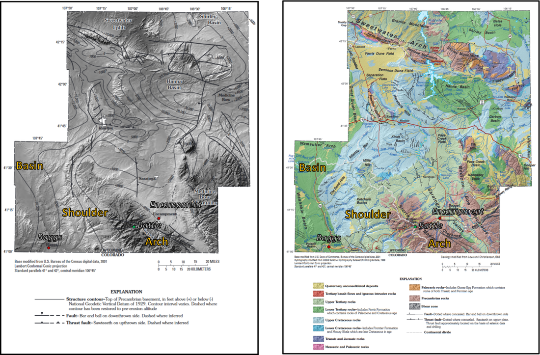
Carbon County basement structure (left) and generalized geologic (right) maps. Basement map shows structural configuration of the County. The geologic map shows the Upper Tertiary shoulders blanketing (light green) the uplifted arches (brown). Structural basins are indicated by Lower Cretaceous rocks (dark green).
Image: After Bartos, T.T., Hallberg, L.L., Mason, J.P., Norris, J.R., and Miller, K.A., 2006, Water resources of Carbon County, Wyoming: U.S. Geological Survey Scientific Investigations Report 2006-5027, Left: Fig. 7, p. 10 & Right: Fig. 2, p.5; https://pubs.usgs.gov/sir/2006/5027/pdf/sir2006-5027.pdf.
Image: After Bartos, T.T., Hallberg, L.L., Mason, J.P., Norris, J.R., and Miller, K.A., 2006, Water resources of Carbon County, Wyoming: U.S. Geological Survey Scientific Investigations Report 2006-5027, Left: Fig. 7, p. 10 & Right: Fig. 2, p.5; https://pubs.usgs.gov/sir/2006/5027/pdf/sir2006-5027.pdf.
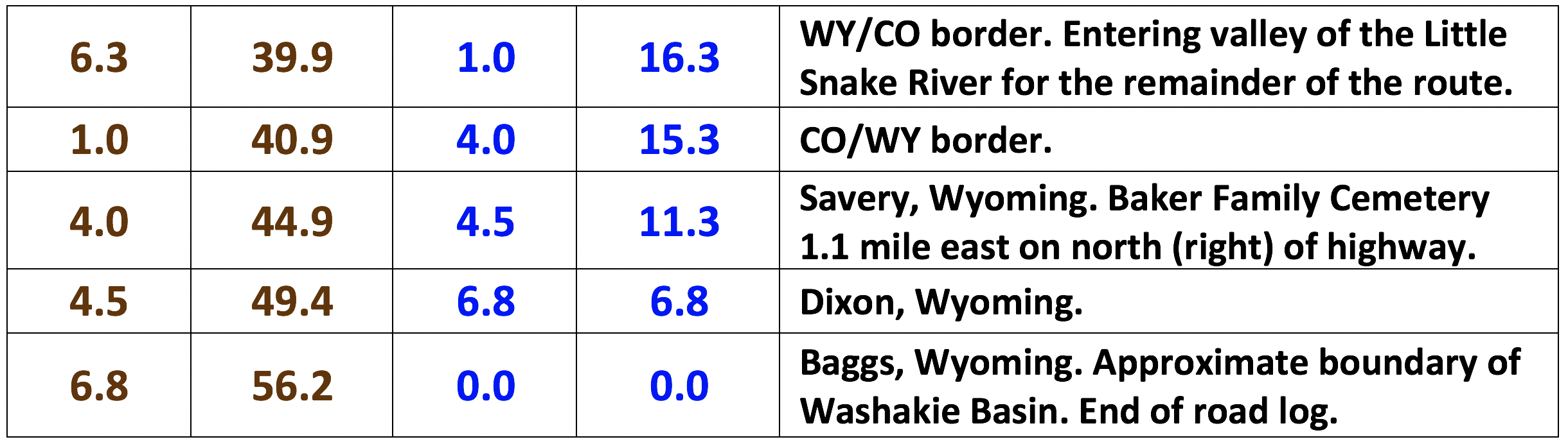
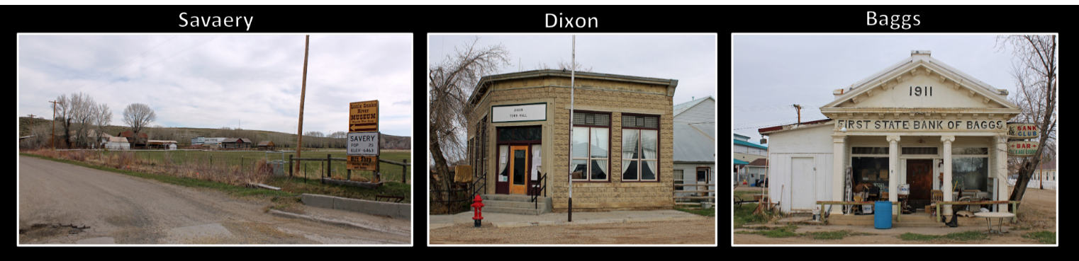
Wyoming towns within the Little Snake River Valley on Wyoming Highway 70. Left: The town of Savery, Wyoming. The complex in the background is the Little Snake River Museum, located on Carbon County Road 561. Middle:
Stockgrowers Bank, located on North 3rd Street in Dixon, Wyoming. The property, now the Dixon Town Hall, is listed on the National Register of Historic Places. Right: The First State Bank of Baggs, located at 10 South Miles Street in Baggs, Wyoming. The property is listed on the National Register of Historic Places. This area was known as outlaw territory due to the isolation of the valley. Butch Cassidy and the Wild Bunch gang hung out in the area. The Gaddis Matthews House in the center of Baggs was a former “hide-out.”
Image: Beall, J., 2014, Wikipedia;
Left: https://upload.wikimedia.org/wikipedia/commons/6/67/Savery%2C_Wyoming.JPG;
Middle: https://en.wikipedia.org/wiki/Dixon,_Wyoming#/media/File:Stockgrowers_Bank.JPG;
Right: https://commons.wikimedia.org/wiki/File:First_State_Bank_of_Baggs.JPG.
Things To Do
- Hiking and biking
- Off-road motoring
- Snowshoeing and cross country skiing
- Snowmobiling
- Green Mountain Falls
- Continental Trail
- Huston Park Wilderness
- Fishing and camping
- Aspen Alley
- Baker Family Cemetery
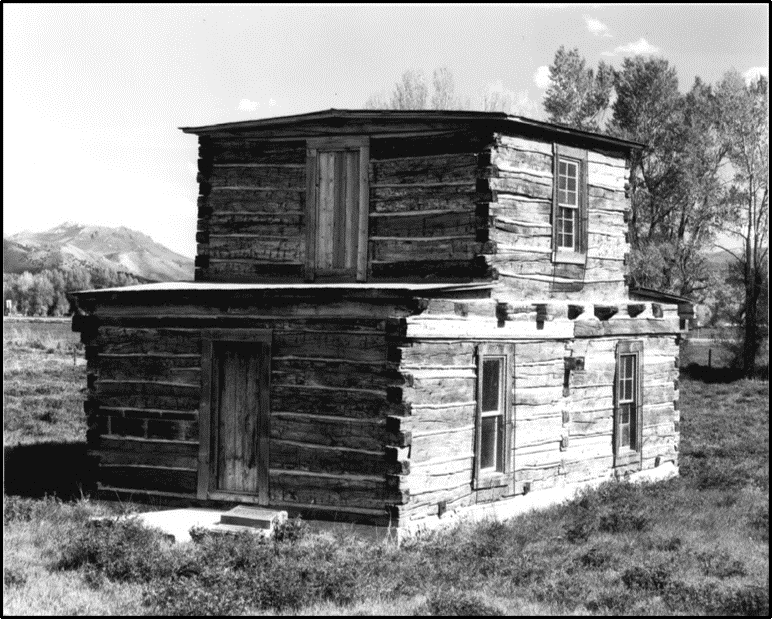
Jim Baker’s cabin, (original location in Section 13, Township 12 North, Range 90 West) Savery, WY.
Image: Junge, M., Undated, Wyoming Recreation Commission Negative No. 1267; https://wyoshpo.wyo.gov/index.php/programs/national-register/wyoming-listings/view-full-list/489-jim-baker-cabin.
Image: Junge, M., Undated, Wyoming Recreation Commission Negative No. 1267; https://wyoshpo.wyo.gov/index.php/programs/national-register/wyoming-listings/view-full-list/489-jim-baker-cabin.
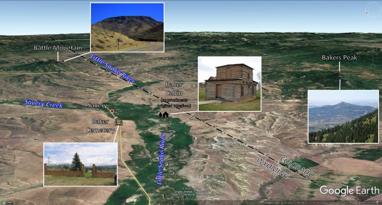
East aerial image of Baker Family Cemetery and cabin in the Little Snake River Valley, with Battle Mountain, WY and Bakers Peak, CO in background.
Image: Base: Google Earth; Battle Mountain: Image: Kallinen, J., , Battle Mountain (formerly Bastion); https://lh5.googleusercontent.com/p/AF1QipN0S1rFGnrrm0qcvDsOxyV2roq3ED5d4rkFf1sJ=h1440; Baker Cabin: Beall, J., 2014; https://upload.wikimedia.org/wikipedia/commons/4/43/Jim_Baker_Cabin.JPG; Baker Cemetery: https://images.findagrave.com/photos/2005/157/CEM46791638_111815391405.jpg; Bakers Peak: https://listsofjohn.com/img/59/58736.jpg.
Image: Base: Google Earth; Battle Mountain: Image: Kallinen, J., , Battle Mountain (formerly Bastion); https://lh5.googleusercontent.com/p/AF1QipN0S1rFGnrrm0qcvDsOxyV2roq3ED5d4rkFf1sJ=h1440; Baker Cabin: Beall, J., 2014; https://upload.wikimedia.org/wikipedia/commons/4/43/Jim_Baker_Cabin.JPG; Baker Cemetery: https://images.findagrave.com/photos/2005/157/CEM46791638_111815391405.jpg; Bakers Peak: https://listsofjohn.com/img/59/58736.jpg.

Left: Jim Baker and "his warmest friend and constant companion," a Sharps buffalo rifle, 1879; Middle & Right Mountain man Jim Baker’s headstone. Inscription reads: Middle: “Here lies Jim Baker Born in Illinois Dec. 19, 1819 Died May 15, 1889”; Right: “One of the oldest Pioneers of the Rocky Mountains. Contemporary of KIT CARSON. JIM BRIDGER. FREMONT. And the rest who helped civilize this district. A government scout, guide, and Indian fighter; His memory should be respected forever by those who live in all this region the fighting land of the Indian tribes.”
Image: Left: https://www.wyohistory.org/encyclopedia/jim-baker-frontier-scout;
Middle & Right: Carter, D., 2009, Jim Baker, The Forgotten Man: American Society of Arms Collectors Bulletin Vol. 99, Fig. 7 & 8, p. 16; https://americansocietyofarmscollectors.org/wp-content/uploads/2019/06/2009-B99-Jim-Baker-The-Forgotten-Man.pdf.
Glen D. Bradley, in a 1912 Pamphlet, wrote:
“The men who comprised the vanguard of western civilization on this continent were of a distinctly peculiar type. They were resourceful and fearless, men who could adapt themselves to rough surroundings, men who could exist in the midst of savagery. The West was not subdued by soft fingered gentry. Winning the West required rough men who were not over scrupulous and who fought the devil with fire. Of such was Jim Baker. Though possessed of a rough exterior and careless habits, he was brave, unselfish, and true to his friends. He was always faithful to duty and his honesty was irreproachable.”
(Bradley, G.D., 1912, Jim Baker: Famous Mountain Man, Scout, Hunter, Guide, and Fighter, Kindle Version, Location 28-32)

The material on this page is copyrighted