Bessemer Mountain with folded Chugwater and Goose Egg Formations
Image: Mark Fisher
Image: Mark Fisher
Wow Factor (2 out of 5 stars):

Geologist Factor (3 out of 5 stars):

Attraction
Famous landmark along the Wyoming emigrant trails is also located at the complex structural intersection of several Laramide structures
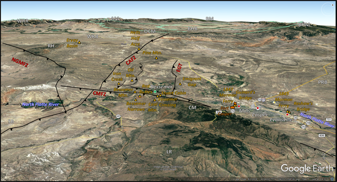
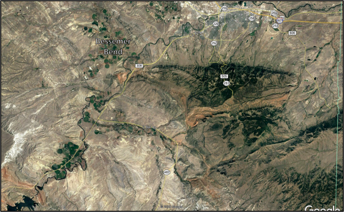
Northwest aerial view of Bessemer Bend area. Abbreviations: AM, Absaroka Mountains; BHB, Bighorn Basin; BHM, Bighorn Mountains; BM, Beartooth Mountains; CAFZ, Casper Arch fault zone; CMFZ, Casper Mountain fault zone; CM, Casper Mountain; EGT, Emigrant Gap thrust fault; LR, Laramie Range; NGMFZ, North Granite Mountain fault zone; OCM, Owl Creek Mountains; PRB, Powder River Basin; RH, Rattlesnake Hills; SB, Shirley Basin; WRB, Wind River Basin; WRR, Wind River Range. Tepee symbols on upthrown side of fault traces. Town dots: Current, red; Abandoned, green.
Image: Google Earth
Image: Google Earth
Bessemer Bend History
Bessemer Bend (Red Butte crossing) is a large meander loop on the North Platte River about ten miles southwest of Casper. This was the last fording location along the 450 mile North Platte trail from Fort Kearney, Nebraska to west of Casper, Wyoming. Downstream from here emigrants had the choice to pay tolls to various ferries or bridges across the river. Whichever crossing they choose, the trail turned southwestward heading towards the Sweetwater River and then westward toward South Pass over the Wind River Mountains. Bessemer Bend was a favored campsite for travelers and the last safe water for about 20 miles.
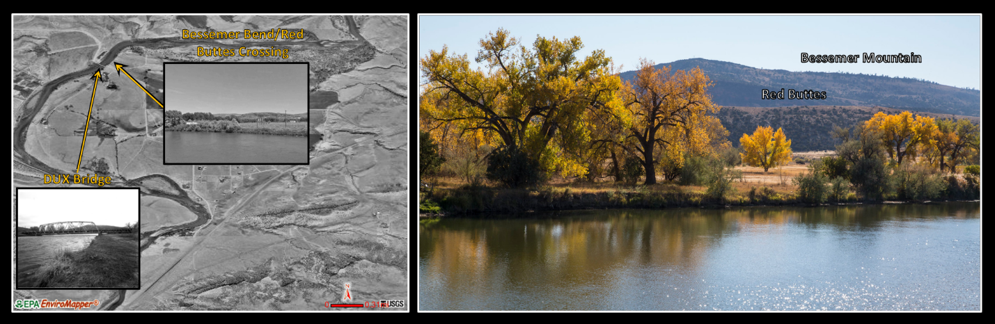
Left: Aerial photo of Bessemer Bend; Right: Bessemer Bend in Autumn. The DUX Bridge across the North Platte, south of the ford, was constructed in 1922 and added to the National Register of Historic Places in 1985.
Image: Left :After http://www.city-data.com/city/Bessemer-Bend-Wyoming.html, Google Earth Street View, &https://npgallery.nps.gov/NRHP/GetAsset/NRHP/85000428_photos ; Right: After Wick, B., 2017, Autumn colors of the North Platte 1 - Bessemer Bend: https://www.flickr.com/photos/134389515@N06/38285970615/in/album-72157689719975771/.
Image: Left :After http://www.city-data.com/city/Bessemer-Bend-Wyoming.html, Google Earth Street View, &https://npgallery.nps.gov/NRHP/GetAsset/NRHP/85000428_photos ; Right: After Wick, B., 2017, Autumn colors of the North Platte 1 - Bessemer Bend: https://www.flickr.com/photos/134389515@N06/38285970615/in/album-72157689719975771/.

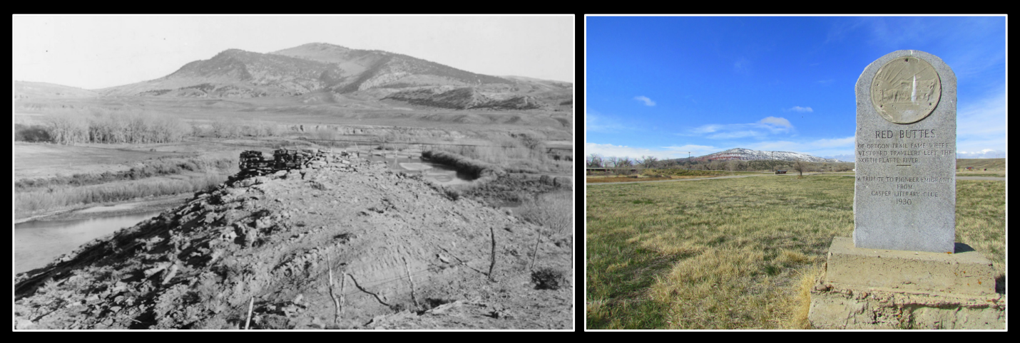
Red Buttes on the North Platte River, now known as Bessemer’s Bend, in 1870 (Left: William Henry Jackson, USGS-jwh00277) and in 2016 (Right: CW-2016-06-18-0385).
Image: : https://lensoftimenorthwest.com/galleries/montana-wyoming/green-wind-sweetwater/red-buttes-north-platte-river/.
Image: : https://lensoftimenorthwest.com/galleries/montana-wyoming/green-wind-sweetwater/red-buttes-north-platte-river/.
The town of Bessemer was founded on the west bank of the North Platte river in 1888 by the Wyoming Improvement Company, a group of Nebraska-based investors. They named the site after Englishman Sir Henry Bessemer, inventor of the Bessemer steel-manufacturing process. They used the optimistic nickname “Queen City of the West (or Plains).” Marketing brochures referred to Bessemer’s location that “borders upon the richest and most extensive oil fields now known to the world…immense deposits of coal…mountains of the finest iron ore" and was destined to be a "great railroad, manufacturing, and industrial centre (sic)." Land was reserved for "the future Capitol of Wyoming." When Natrona county was established in 1889, Bessemer competed with Casper for the county seat in an election. The results showed Bessemer received more than twice the number of votes as Casper. This was also twice the number of community residents living in Bessemer at the time. Bessemer lost the election due to fraudulent voting. The election results were invalidated, and Casper became the county seat. The disappointed residents soon left, the town structures disappeared, and the land today is home to alfalfa fields and a fish hatchery.
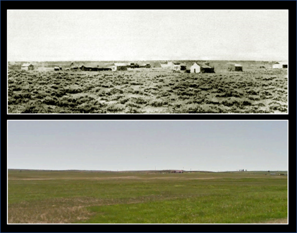
Bessemer Wyoming, 1892 (top) and approximate location today (bottom).
Image: Top: http://www.wyomingtalesandtrails.com/bessemer.html; Bottom: Google Earth Street View.
Image: Top: http://www.wyomingtalesandtrails.com/bessemer.html; Bottom: Google Earth Street View.
Bessemer Bend Geology
A couple miles southwest of Bessemer Bend, the North Platte River flows over the west nose of the Casper Mountain Anticline (fold). This spot is called the Bessemer Narrows and was carved by the superposed Platte River from a high surface of Tertiary fill. Tertiary fill is preserved at the Granite Mountains (see https://www.geowyo.com/granite-mountains.html) and east of the Rockies in the western Dakotas, Nebraska and Kansas (see Lusk Area: High Plains of Wyoming, and Goshen Hole Region).
The assemblage of Wyoming, and the North America continent began when plate tectonics suture old Archean crust (cratons), island arcs, and adjacent sedimentary basins (greenstone belts) in a series of collisions during the Proterozoic. The fabric and stresses imparted to the crust influenced the location and orientation of folds and faults seen in the Bessemer area that formed much later during the Laramide mountain building event (70 to 50 million years ago).
Casper Mountain is a doubly plunging arch formed by Laramide tectonics. The west-east orientation is inherited from the Precambrian architecture that was reactivated during the Laramide. The left-lateral oblique movement on the Casper Mountain fault zone is typical of the west-east oriented ranges in Wyoming. Structures on the downthrown side of these bounding faults generally trend northwest and are cut off at the fault trace.
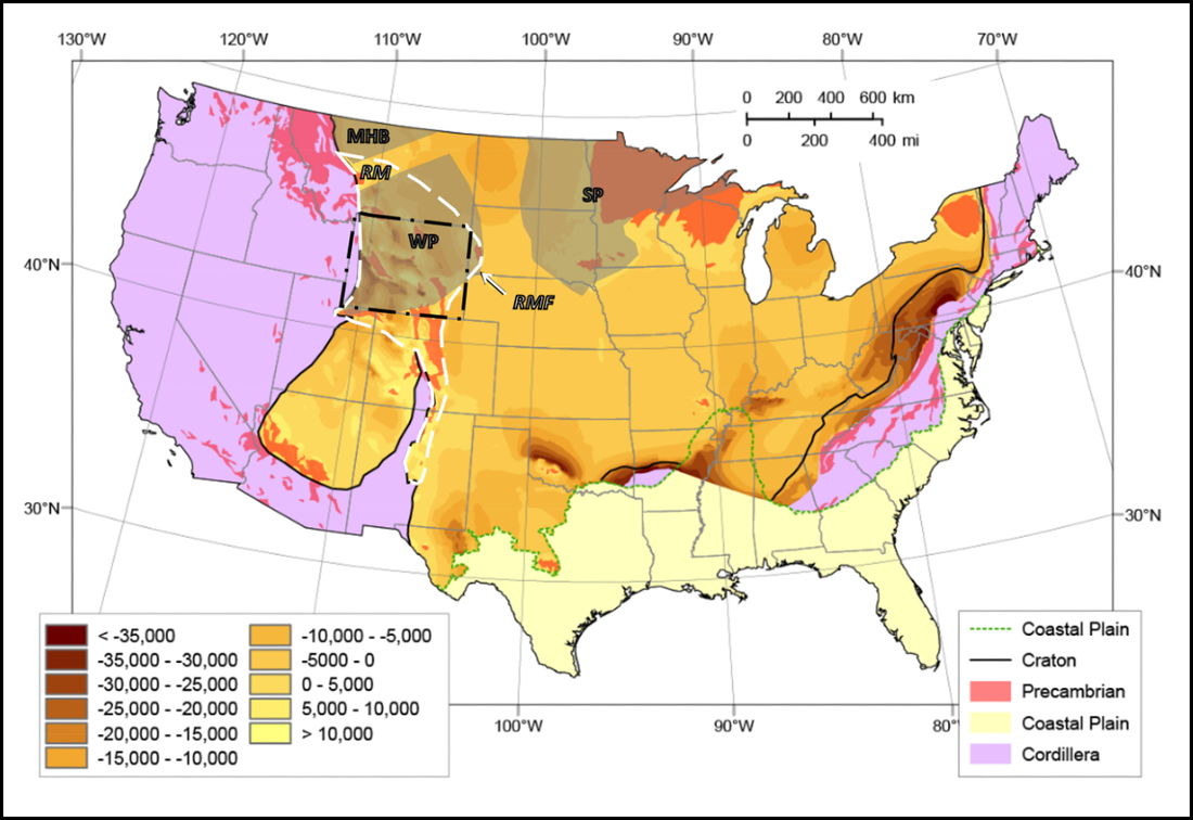
Digital elevation model of the basement of the United Sates, in shaded relief. Brown areas represent the cratonic platform crust of the continent. Gray shaded areas represent Archean cratonic rocks: MHP = Medicine Hat Block; SP = Superior Province; WP = Wyoming Province. White Dashed area represents the Phanerozoic Rocky Mountain tectonic domain: RM = Rocky Mountains; RMF = Rocky Mountain Front. Red areas are outcrops of Precambrian rocks.
Image: After Marshak, S., Domrois, S., Abert, C., Larson, T., Pavlis, G., Hamburger, M., Yang, X., Gilbert, H., and Chen, C., 2017, The basement revealed: Tectonic insight from a digital elevation model of the Great Unconformity, USA, cratonic platform: Geology, Vol. 45, No. 5, Fig. 2, p. 392; and Geological Society of America Data Repository 2017115, Fig DR1A; https://www.geosociety.org/datarepository/2017/2017115.pdf .
Image: After Marshak, S., Domrois, S., Abert, C., Larson, T., Pavlis, G., Hamburger, M., Yang, X., Gilbert, H., and Chen, C., 2017, The basement revealed: Tectonic insight from a digital elevation model of the Great Unconformity, USA, cratonic platform: Geology, Vol. 45, No. 5, Fig. 2, p. 392; and Geological Society of America Data Repository 2017115, Fig DR1A; https://www.geosociety.org/datarepository/2017/2017115.pdf .

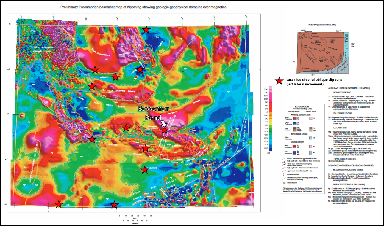
Precambrian basement map of Wyoming showing three geological domains: 1) magmatic = potassic granite-granodiorite (orange = outcrop; gold = subsurface); 2) gneiss (brown = outcrop; tan = subsurface) 3) Proterozoic orogens = supracrustal metavolcanic-metasedimentary rocks (gray & blue) interpreted from aeromagnetic data. The banding of Archean rocks reflects the assembly of the Wyoming craton. Younger Proterozoic accreted terranes in southeast (Colorado Orogen, 1.78-1.65 Ga) and eastern (Tans-Hudson Orogen, 1.9-1.84 Ga) Wyoming represent accreted terrane form the assembly of North America. Laramide west-east structural zones with inherited Precambrian fabric shown by red stars.
Image: After Sims, P.K., Finn, C.A., and Rystrom, V.L., 2001, Preliminary Precambrian basement map showing geologic—geophysical domains, Wyoming: U.S. Geological Survey, Open-File Report 01-199, Top: Plate 1; Bottom: Plate 2; https://pubs.usgs.gov/of/2001/ofr-01-0199/.
Image: After Sims, P.K., Finn, C.A., and Rystrom, V.L., 2001, Preliminary Precambrian basement map showing geologic—geophysical domains, Wyoming: U.S. Geological Survey, Open-File Report 01-199, Top: Plate 1; Bottom: Plate 2; https://pubs.usgs.gov/of/2001/ofr-01-0199/.
Precambrian basement map of Wyoming showing magnetic signature of rocks.
Image: After Sims, P.K., Finn, C.A., and Rystrom, V.L., 2001, Preliminary Precambrian basement map showing geologic—geophysical domains, Wyoming: U.S. Geological Survey, Open-File Report 01-199, Top: Plate 1; Bottom: Plate 2; https://pubs.usgs.gov/of/2001/ofr-01-0199/.
Image: After Sims, P.K., Finn, C.A., and Rystrom, V.L., 2001, Preliminary Precambrian basement map showing geologic—geophysical domains, Wyoming: U.S. Geological Survey, Open-File Report 01-199, Top: Plate 1; Bottom: Plate 2; https://pubs.usgs.gov/of/2001/ofr-01-0199/.
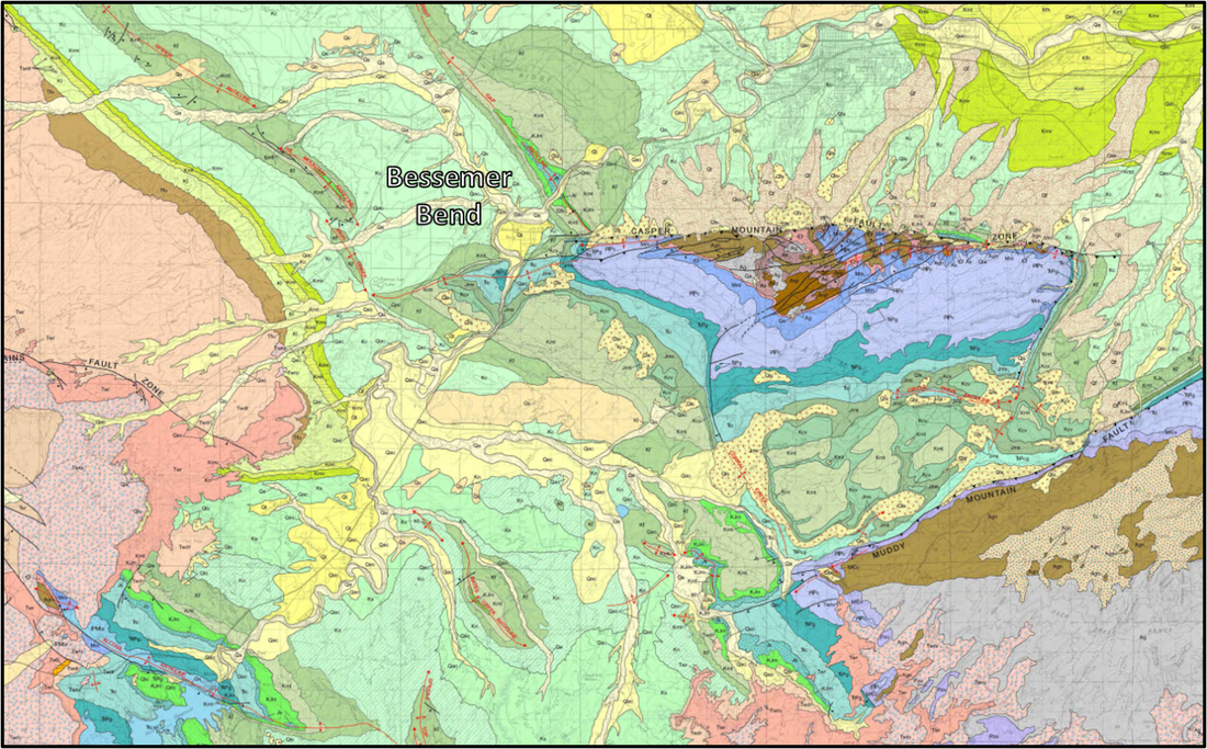
Geologic map of the Bessemer Bend and Casper area.
Image: Hunter, John, Ver Ploeg, A.J., and Boyd, C.S., 2005, Geologic map of the Casper 30' x 60' quadrangle, Natrona and Converse counties, Wyoming: Wyoming State Geological Survey Map Series 65, scale 1:100,000; http://sales.wsgs.wyo.gov/geologic-map-of-the-casper-30-x-60-quadrangle-natrona-and-converse-counties-central-wyoming-2005/
Image: Hunter, John, Ver Ploeg, A.J., and Boyd, C.S., 2005, Geologic map of the Casper 30' x 60' quadrangle, Natrona and Converse counties, Wyoming: Wyoming State Geological Survey Map Series 65, scale 1:100,000; http://sales.wsgs.wyo.gov/geologic-map-of-the-casper-30-x-60-quadrangle-natrona-and-converse-counties-central-wyoming-2005/
Aerial view of the Bessemer Bend geologic map area.
Image: Google Earth.
Image: Google Earth.

Tectonic map of the Bessemer Bend area and Casper Mountain area. Faults are shown in heavy black lines with teeth on the upthrown side of the reverse faults. Movement direction on the faults is also noted by “D” on downthrown side and ‘U” on upthrown side. Major folds in the sedimentary rocks parallel these faults and are shown with thin black lines at the crest of the folds. Opposing arrows point away from the crest of these folds. Most of the folds shown on this map are anticlines, shaped like an elongated umbrella or elongated upside down bowl.
Image: After Stone, D.S., 2002, Morphology of the Casper Mountain uplift and Related, subsidiary structures, central Wyoming; Implications for Laramide kinematics, dynamics, and crustal inheritance: American Association of Petroleum Geologists Bulletin, v. 86, no. 8, Fig. 2B, p. 1419.
Image: After Stone, D.S., 2002, Morphology of the Casper Mountain uplift and Related, subsidiary structures, central Wyoming; Implications for Laramide kinematics, dynamics, and crustal inheritance: American Association of Petroleum Geologists Bulletin, v. 86, no. 8, Fig. 2B, p. 1419.
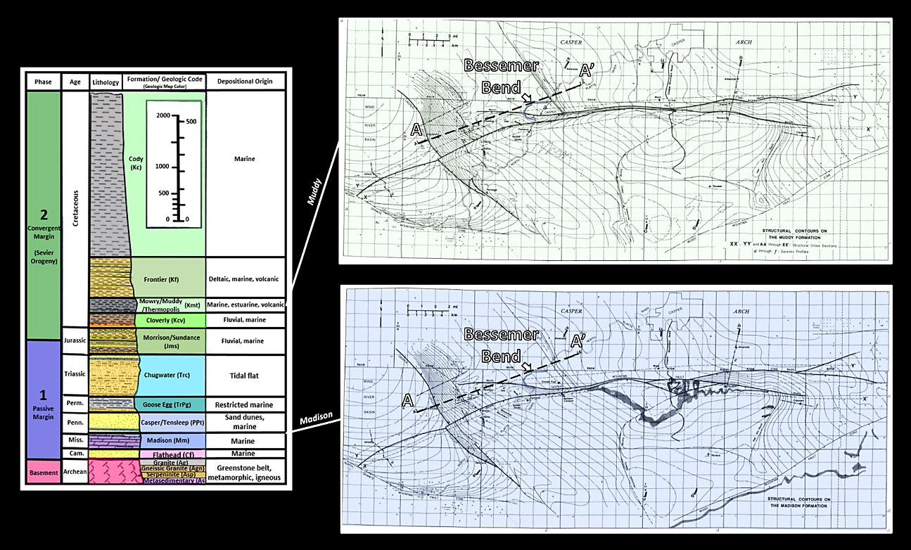
Stratigraphic column, Cretaceous Muddy (top) and Mississippian Madison (bottom) structure maps for Bessemer Bend area. Cross section AA’ location shown by black dashed line.
Image: After Stone, D.S., 2002, Morphology of the Casper Mountain uplift and Related, subsidiary structures, central Wyoming; Implications for Laramide kinematics, dynamics, and crustal inheritance: American Association of Petroleum Geologists Bulletin, v. 86, no. 8, Fig. 3, p. 1420, Fig 4A &B
Image: After Stone, D.S., 2002, Morphology of the Casper Mountain uplift and Related, subsidiary structures, central Wyoming; Implications for Laramide kinematics, dynamics, and crustal inheritance: American Association of Petroleum Geologists Bulletin, v. 86, no. 8, Fig. 3, p. 1420, Fig 4A &B
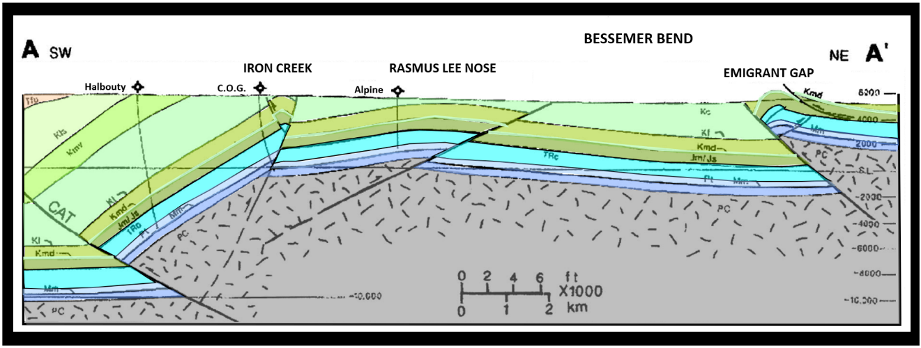
Structural cross section A to A’ is entirely in Casper Mountain footwall or downthrown block. Structure maps in previous figure are made on the Muddy Sandstone (Kmd) shown in a very thin light green line on this cross section and on the Madison Limestone (Mm) shown in darker blue on this cross section.
Image: After: Stone, D.S., 2002, Morphology of the Casper Mountain uplift and Related, subsidiary structures, central Wyoming; Implications for Laramide kinematics, dynamics, and crustal inheritance: American Association of Petroleum Geologists Bulletin, v. 86, no. 8, Fig. 5A, p. 1422.
Image: After: Stone, D.S., 2002, Morphology of the Casper Mountain uplift and Related, subsidiary structures, central Wyoming; Implications for Laramide kinematics, dynamics, and crustal inheritance: American Association of Petroleum Geologists Bulletin, v. 86, no. 8, Fig. 5A, p. 1422.
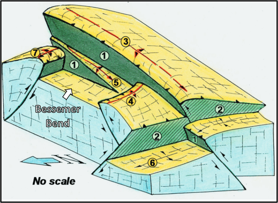
Three-dimensional diagram of fault intersections at the basement level, Casper Mountain. View is to the southeast. Number structure codes: 1) Casper Mountain fault zone; 2) Casper Arch thrust zone; 3) Casper Mountain anticline; 4) Iron Creek anticline and back thrust; 5) Rasmus Lee nose; 6) Wind River Basin axis; 7) Emigrant Gap anticline and thrust.
Stone, D.S., 2013, Using freehand three-dimensional drawings to clarify and verify subsurface structural interpretations, in C. Knight and J. Cuzella, eds., Application of structural methods to Rocky Mountain hydrocarbon exploration and development: AAPG Studies in Geology 65, Fig. 4A, p. 5; http://store-assets.aapg.org/documents/previews/1198ST65/CHAPTER01.PDF
Stone, D.S., 2013, Using freehand three-dimensional drawings to clarify and verify subsurface structural interpretations, in C. Knight and J. Cuzella, eds., Application of structural methods to Rocky Mountain hydrocarbon exploration and development: AAPG Studies in Geology 65, Fig. 4A, p. 5; http://store-assets.aapg.org/documents/previews/1198ST65/CHAPTER01.PDF
You can stand at the confluence of Poison Spider Creek and the North Platte River, Bessemer Bend area, where Wyoming’s first non-native cabin was erected in 1812 by Robert Stuart’s party of Astorian fur trappers. Emigrants on the California, Oregon and Mormon trails also camped at this spot. The Hayden Survey, the first government funded scientific study of the upper Rocky Mountain West, camped at Red Buttes in 1870 (Marker location: 42° 46.452′ N, 106° 31.79′ W). Here one can imagine the geologic forces that stitched together Wyoming, and then North America. Massive Himalaya-type mountains and volcanic arcs have risen near here and now vanished into the “Great Unconformity” at the Precambrian-Phanerozoic surface. Laramide tectonism created new uplifts and basins that reactivated Precambrian zones of weakness. Bessemer Bend is a spot where the complex structure beneath one’s feet records this geologic story.
First cabin in Wyoming and Red Buttes marker at confluence of Poison Spider Creek and the North Platte River, Bessemer Bend (42o 46’ 25.61’ N, 106o 31’ 50.75” W).
Image: Left: Exploring the Nature of Wyoming: University of Wyoming Extension, 2017, Robert Stuart, the Astorians, & the First Cabin in Wyoming; https://www.youtube.com/watch?v=twmo8froAwI. Right:https://lh5.googleusercontent.com/p/AF1QipNIKEDxMqIxolRT9_9vBMtsnKHBt4Q9NtFoubdg=h1440
Image: Left: Exploring the Nature of Wyoming: University of Wyoming Extension, 2017, Robert Stuart, the Astorians, & the First Cabin in Wyoming; https://www.youtube.com/watch?v=twmo8froAwI. Right:https://lh5.googleusercontent.com/p/AF1QipNIKEDxMqIxolRT9_9vBMtsnKHBt4Q9NtFoubdg=h1440
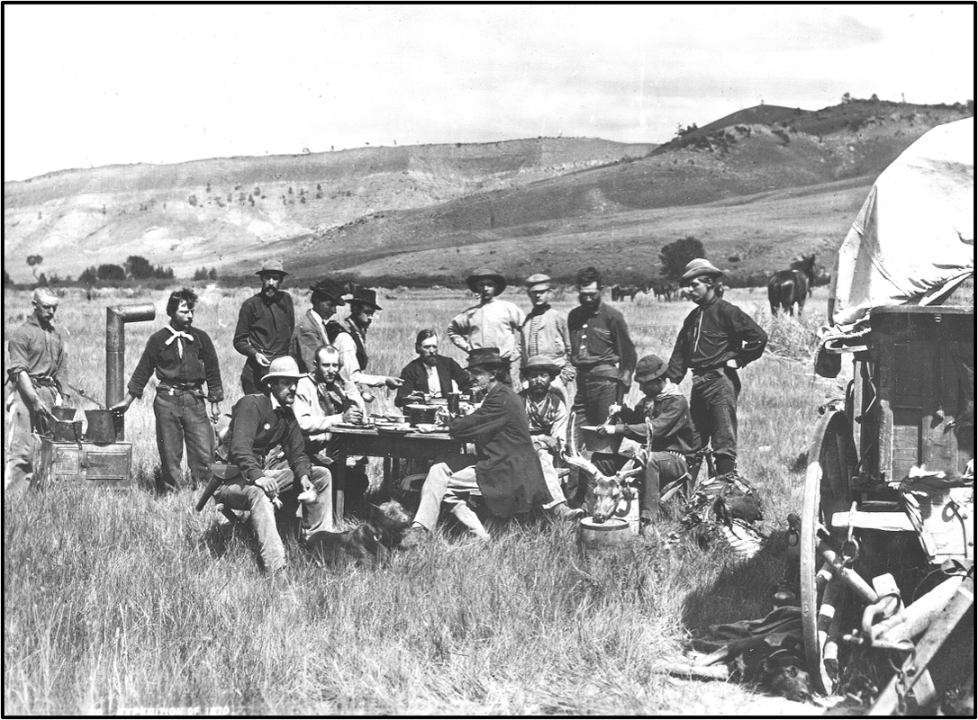
All the members of the Hayden Survey, made while in camp at Red Buttes at the junction of the North Platte and Sweetwater Rivers, Natrona County, Wyoming, 1870. Standing left to right: John "Potato John" Raymond and "Val," cooks; Sanford R. Gifford, landscape painter; Henry W. Elliott, artist; James Stevenson, assistant; H.D. Schmidt, naturalist; E. Campbell Carrington, zoologist; L.A. Bartlett, general assistant; William Henry Jackson, photographer. Sitting left to right: C.S. Turnbull, secretary; J.H. Beaman, meteorologist; Ferdinand. V. Hayden, geologist in charge; Cyrus Thomas, agriculturist; Raphael, hunter; A.L. Ford, mineralogist.
Image: Jackson, W.H., 1870, Red Buttes camp; https://en.wikipedia.org/wiki/Ferdinand_Vandeveer_Hayden#/media/File:Hayden_Wyoming_1870_jwh00282.jpg
Image: Jackson, W.H., 1870, Red Buttes camp; https://en.wikipedia.org/wiki/Ferdinand_Vandeveer_Hayden#/media/File:Hayden_Wyoming_1870_jwh00282.jpg
Things-To-Do Bessemer Bend
The BLM has a small park on the northwest bank of the North Platte River at the Bessemer Bend emigrant crossing. It is a tranquil spot with a short trail and interpretive signs. Directions: Take Wyoming 220 southwest out of Casper 8.1 miles from the intersection of CY Avenue and Wyoming Boulevard. Turn right on Bessemer Bend Road, travel 2 miles to bridge over North Platte River. After crossing the bridge, the BLM park is immediately on the right.
Link to BLM Bessemer Bend website: https://www.blm.gov/visit/bessemer-bend
Link to Geowyo Casper Mountain website: https://www.geowyo.com/casper-mountain.html
Link to BLM Bessemer Bend website: https://www.blm.gov/visit/bessemer-bend
Link to Geowyo Casper Mountain website: https://www.geowyo.com/casper-mountain.html
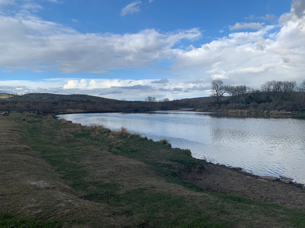
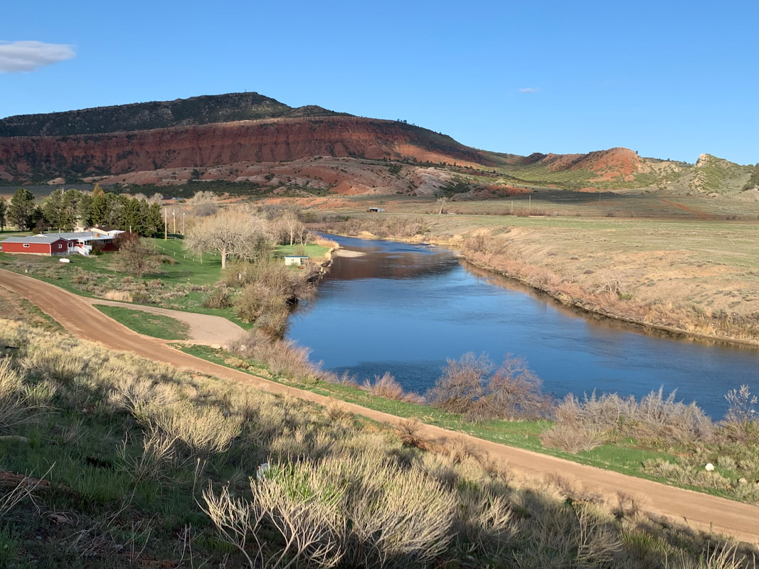
North Platte River at BLM Bessemer Bend emigrant crossing park
Image: Mark Fisher
Image: Mark Fisher

The material on this page is copyrighted