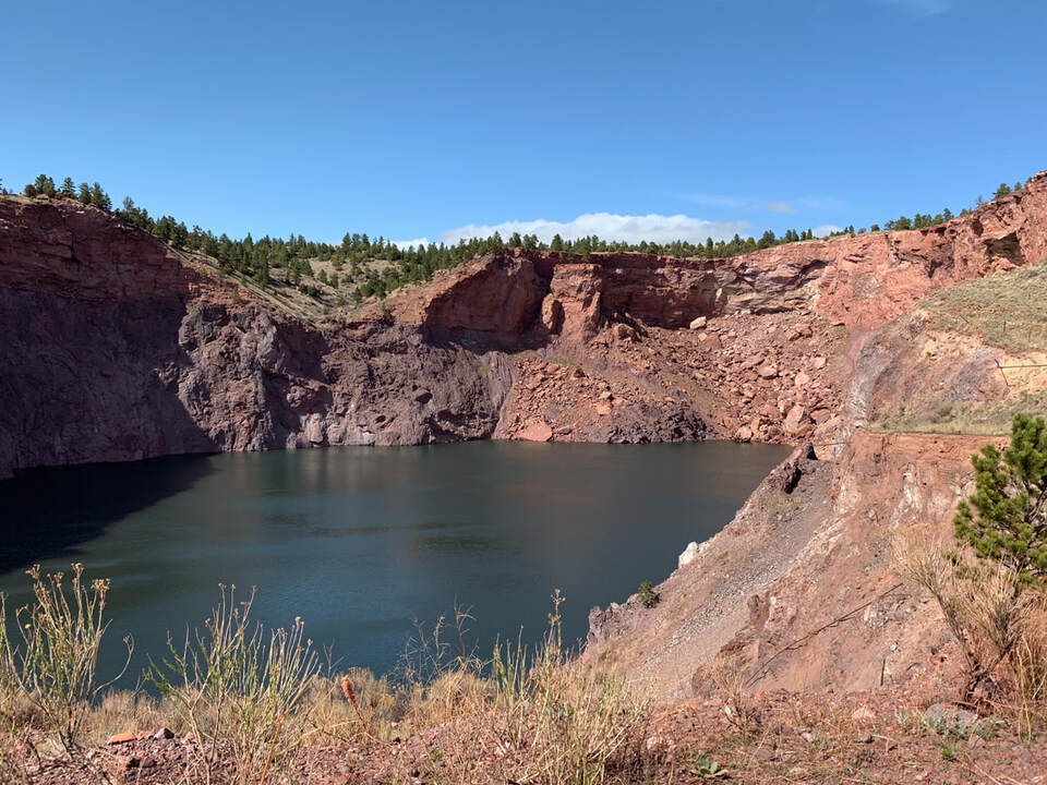
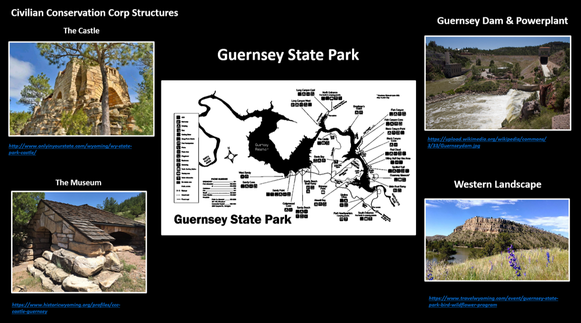
Flooded iron ore mine pit at Sunrise with layered light pink Mississippian Guernsey carbonates overlying darker Archean iron ore
Image by Mark Fisher
Image by Mark Fisher
Wow Factor (4 out of 5 stars):
Geologist Factor (3 out of 5 stars):
Attraction
Fort Laramie History
Fort Laramie, a National Historical Landmark (Smithsonian No. 48GO1),is located on a stream terrace at the confluence of the North Platte and Laramie rivers. It is the geographic point where the Emigrant Trails leave the Great Plains and enter the broken topography of the Rocky Mountain foothills. Snow-clad Laramie Peak rises on the western horizon warning of the rough road ahead. The first post here was established in 1834 by William Sublette and Robert Stuart to supply fur trappers at their rendezvous. The site had plentiful water, grass and was about halfway between the Missouri River landings and the Upper Green River area.
The U.S. Army purchased the site in 1849 to establish a fort to protect the emigrant trails. This was the first permanent military outpost in Wyoming and its closing in 1890 marked the closing of the American frontier. Contrary to the image of Indian attacks in movies, the trails were relatively peaceful. “Circling the wagons” had more to do with corralling livestock than defense against attack. Another National Historic Landmark (Smithsonian No. 48GO237)is the Three Mile Hog Ranch a nearby bordello established in 1874. This was one of the few Army outpost bordellos remaining in the western United States. It provided a more convenient location for the soldiers than those in Hartville 15 miles away. Calamity Jane is reported to have worked there. The bordello closed when the soldiers left.
The U.S. Army purchased the site in 1849 to establish a fort to protect the emigrant trails. This was the first permanent military outpost in Wyoming and its closing in 1890 marked the closing of the American frontier. Contrary to the image of Indian attacks in movies, the trails were relatively peaceful. “Circling the wagons” had more to do with corralling livestock than defense against attack. Another National Historic Landmark (Smithsonian No. 48GO237)is the Three Mile Hog Ranch a nearby bordello established in 1874. This was one of the few Army outpost bordellos remaining in the western United States. It provided a more convenient location for the soldiers than those in Hartville 15 miles away. Calamity Jane is reported to have worked there. The bordello closed when the soldiers left.
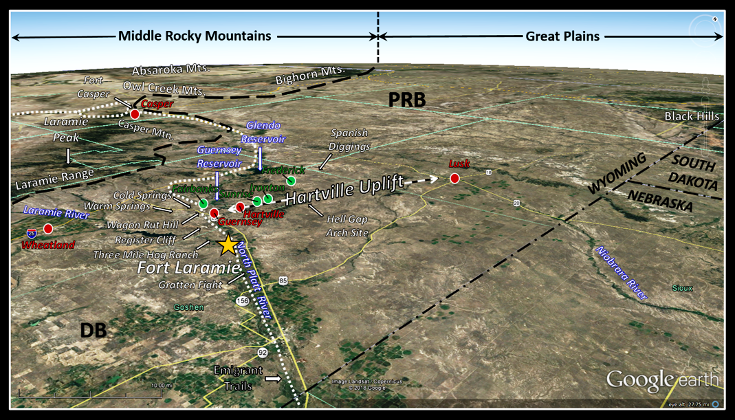
Northwest aerial view of Fort Laramie (yellow star) and Hartville Uplift area. Approximate boundary between the Rocky Mountains and the Great Plains shown by black dashed line. The Hartville Uplift is the structural divide separating the southern Powder River Basin (PRB) from the northern Denver Basin (DB). Area historical sites are labeled with white text and arrows. The emigrant trails follow the white dotted line. Red dots and labels: towns, green dots and labels: abandoned mining towns.
Image by Google Earth
Image by Google Earth
The fort was the site of two treaty signings with Plains Indians. The first in 1851 guaranteed the safe passage of emigrants in exchange for annuities and the recognition of tribal territories. The second in 1868 was to restore peace and grant the Black Hills to the Sioux. About eight miles southeast of the fort is the location of the 1854 Gattan Fight (called a massacre in the press). This was the incident that sparked the First Sioux War. The calamitous intersection of a camp of starving Indians waiting for their late annuity payment, a lame cow that wandered from it’s Mormon owner, and a brash Army officer who hated Indians led to the deaths of 30 soldiers, one intoxicated translator, one Indian chief, and 22 years of conflict on the plains.
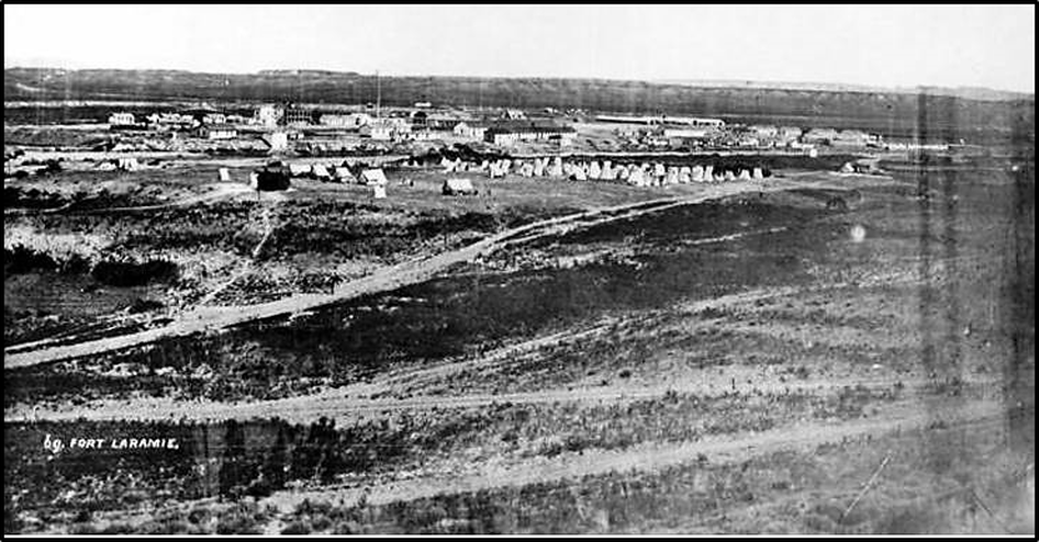
Fort Laramie in 1870. Notice there is no stockade around the fort. Fort Laramie was always an open fort that was never attacked by Indians.
Image: U.S. Signal Corps, 1870; https://www.nps.gov/fola/learn/historyculture/index.htm
Image: U.S. Signal Corps, 1870; https://www.nps.gov/fola/learn/historyculture/index.htm
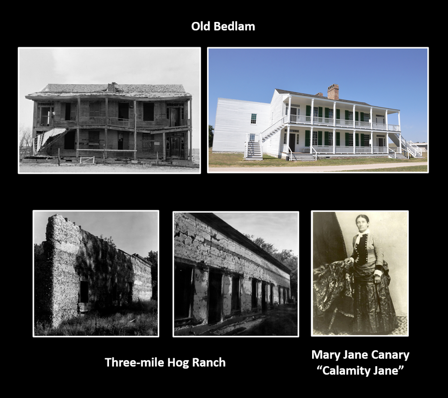
Top: “Old Bedlam” structure before and after restoration. The building served as both base headquarters and officers’ quarters. It is the oldest standing military building in Wyoming. Bottom: Fort Laramie’s nearby bordello and a woman reported to work there.
Image: Top Left: Historic American Buildings Survey (Library of Congress), 1933; https://www.loc.gov/resource/hhh.wy0002.photos/?sp=2; Top Right: Hermans, P., 2014, Old Bedlam; https://upload.wikimedia.org/wikipedia/commons/c/c1/Fort_Laramie_National_Historic_Site_Old_Bedlam_16-9-2014_13-37-40.JPG; Bottom Left & Center: https://npgallery.nps.gov/NRHP/GetAsset/a4b4b41d-0d1f-4754-b000-b60a39919e1e?branding=NRHP; Bottom Right: https://www.pinterest.com/pin/221380137903780651/
Image: Top Left: Historic American Buildings Survey (Library of Congress), 1933; https://www.loc.gov/resource/hhh.wy0002.photos/?sp=2; Top Right: Hermans, P., 2014, Old Bedlam; https://upload.wikimedia.org/wikipedia/commons/c/c1/Fort_Laramie_National_Historic_Site_Old_Bedlam_16-9-2014_13-37-40.JPG; Bottom Left & Center: https://npgallery.nps.gov/NRHP/GetAsset/a4b4b41d-0d1f-4754-b000-b60a39919e1e?branding=NRHP; Bottom Right: https://www.pinterest.com/pin/221380137903780651/
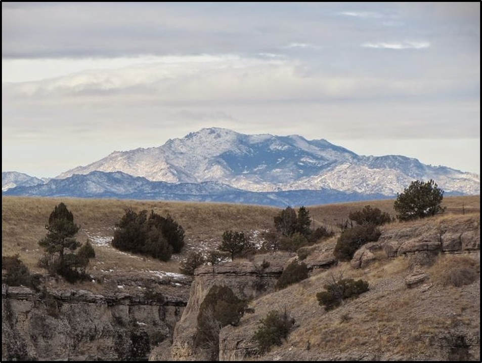
West view of Laramie Peak from Guernsey State Park. Immigrants got their first glimpse of this peak near Scotts Bluff, NB, 85 miles to the east. It was a constant reminder of the hard road ahead in the Rocky Mountains.
Image: https://www.pinterest.com/source/visitguernseystatepark.blogspot.com
Image: https://www.pinterest.com/source/visitguernseystatepark.blogspot.com
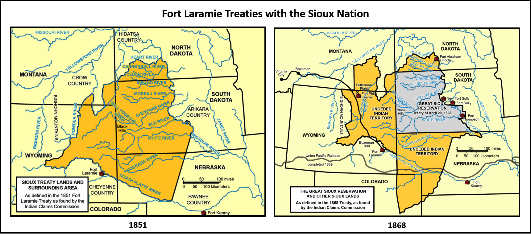
Fort Laramie Treaty Maps of Sioux land. Left: 1851, Right: 1868. In the 1851 treaty the tribes were promised a $50,000 annual annuity in merchandise and provisions. The annuity payment duration was decreased from 50 to 10 years. The annuity was often late and sometimes never paid. This was one of the factors that led to the Grattan Fight
Image: State Historical Society of North Dakota, 2018, North Dakota Studies Program;
https://www.ndstudies.gov/gr8/content/unit-iii-waves-development-1861-1920/lesson-4-alliances-and-conflicts/topic-2-sitting-bulls-people/section-3-treaties-fort-laramie-1851-186
Image: State Historical Society of North Dakota, 2018, North Dakota Studies Program;
https://www.ndstudies.gov/gr8/content/unit-iii-waves-development-1861-1920/lesson-4-alliances-and-conflicts/topic-2-sitting-bulls-people/section-3-treaties-fort-laramie-1851-186
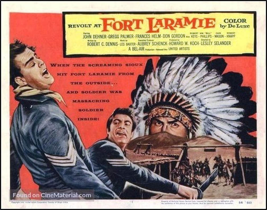
“Revolt at Fort Laramie” movie poster. This 1957 horse opera pits soldiers divided by regional loyalties at the beginning of the American Civil War against the Sioux Indians attacking at Fort Laramie. Historical note: The plot has little resemblance to historical facts. The Dakota War, the second Sioux War, of the early 1860's was fought mainly in western Minnesota and the Dakota territory. The main grievance was the failure of the government to pay the annual annuity guaranteed by the 1851 Fort Laramie Treaty. Red Cloud, the Indian chief leading the attack in the film, was an Oglala Lakota who never attacked Fort Laramie but did lead the third of the Sioux Wars, Red Cloud’s War, from 1866 to 1868 after the Civil War. That conflict was over control of the western Powder River basin grasslands and hunting grounds. The land was Crow territory, guaranteed by the first Fort Laramie Treaty. The U.S. Army had established three forts to protect these hunting grounds and the Bozeman Trail. Red Cloud signed the Fort Laramie Treaty of 1868. The Dakota War leaders were Little Crow, Big Eagle, and Wabasha III of the eastern Sioux (Santee). Contrary to the movie premise, Fort Laramie hosted "Galvanized Yankees" (Confederate POW's that volunteered to serve in the U.S. Army at western Indian territory forts) during the American Civil War.
Image:https://m.imdb.com/title/tt0050895/
Image:https://m.imdb.com/title/tt0050895/
Between 1843 and 1869 about 500,000 people and their livestock passed Fort Laramie on the road west. Mormons travelled on the north bank of the North Platte River, while almost everyone else on the south. Both routes required crossing a river to reach the fort. Southern immigrants had to cross the Laramie River, while those on the north bank had a more difficult crossing of the North Platte. The heavy immigrant traffic cut through the range of the vast bison herds that grazed the plains. The bison population was split into northern and southern herds. Millions of bison were hunted nearly to extinction, but a few dozen wild bison survived in the Yellowstone Park area. With protection and wildlife management, they were saved from extinction.
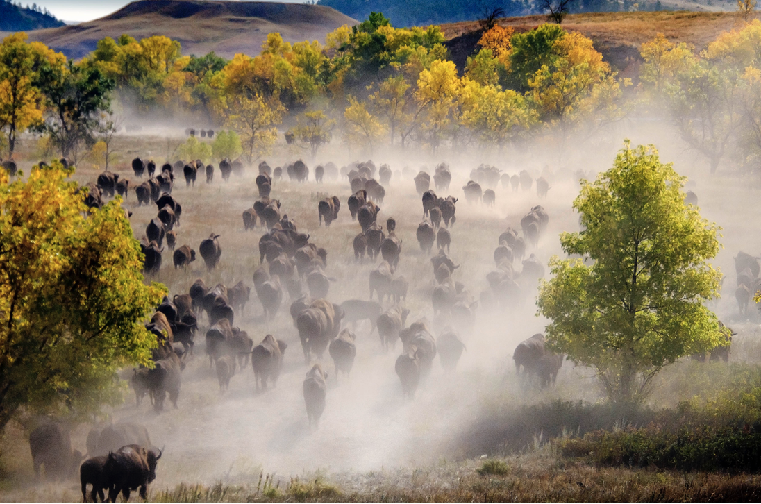
Bison herd at Custer State Park, South Dakota
https://gfp.sd.gov/buffalo-roundup/Image
https://gfp.sd.gov/buffalo-roundup/Image
Hartville Uplift Geology
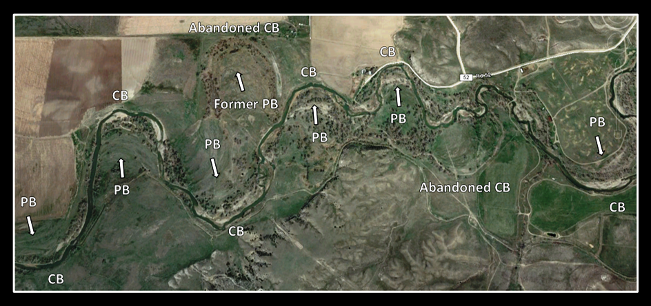
Both rivers meander in their respective stream valleys. Terraces, active and abandoned meander loops and expanding point bar sequences are visible. Some geomorphologists argue that the Laramie River is an “underfit stream.” This is a stream whose flow is too low to account for the channel characteristics (meander radius, wavelength and channel width, or valley size). Primary causes for this are the piracy of flow by stream capture, climate change, or man-made changes (dams, irrigation, etc.).
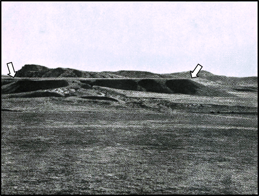
The oldest rock cropping out in the fort area is the Miocene Arikaree Formation. This unit consists of 700 feet of tuffaceous sandstone with occasional limestone concretions. Only the upper portion is exposed in the area. It is this part of the Arikaree Formation that forms the sandstone bluff at Register Cliff and the bedrock into which the wagon ruts were carved near Guernsey.
The oldest rock cropping out in the fort area is the Miocene Arikaree Formation. This unit consists of 700 feet of tuffaceous sandstone with occasional limestone concretions. Only the upper portion is exposed in the area. It is this part of the Arikaree Formation that forms the sandstone bluff at Register Cliff and the bedrock into which the wagon ruts were carved near Guernsey.
North Platte River gravel capped terrace developed in the Miocene Arikaree Formation (white arrows). The Pennsylvanian Hartville Formation outcrops in the distance.
Image: Smith, W.S.T., 1903, The Hartville Folio: U.S. Geological Survey Geologic Folio No. 91, Illustration Sheet, Fig. 2; https://pubs.er.usgs.gov/publication/gf91
Image: Smith, W.S.T., 1903, The Hartville Folio: U.S. Geological Survey Geologic Folio No. 91, Illustration Sheet, Fig. 2; https://pubs.er.usgs.gov/publication/gf91
Laramie River just west of Fort Laramie. Notation: CB: cut bank, PB: point bar, Arrows: point in the direction of point bar growth.
Image: Google Earth
Image: Google Earth
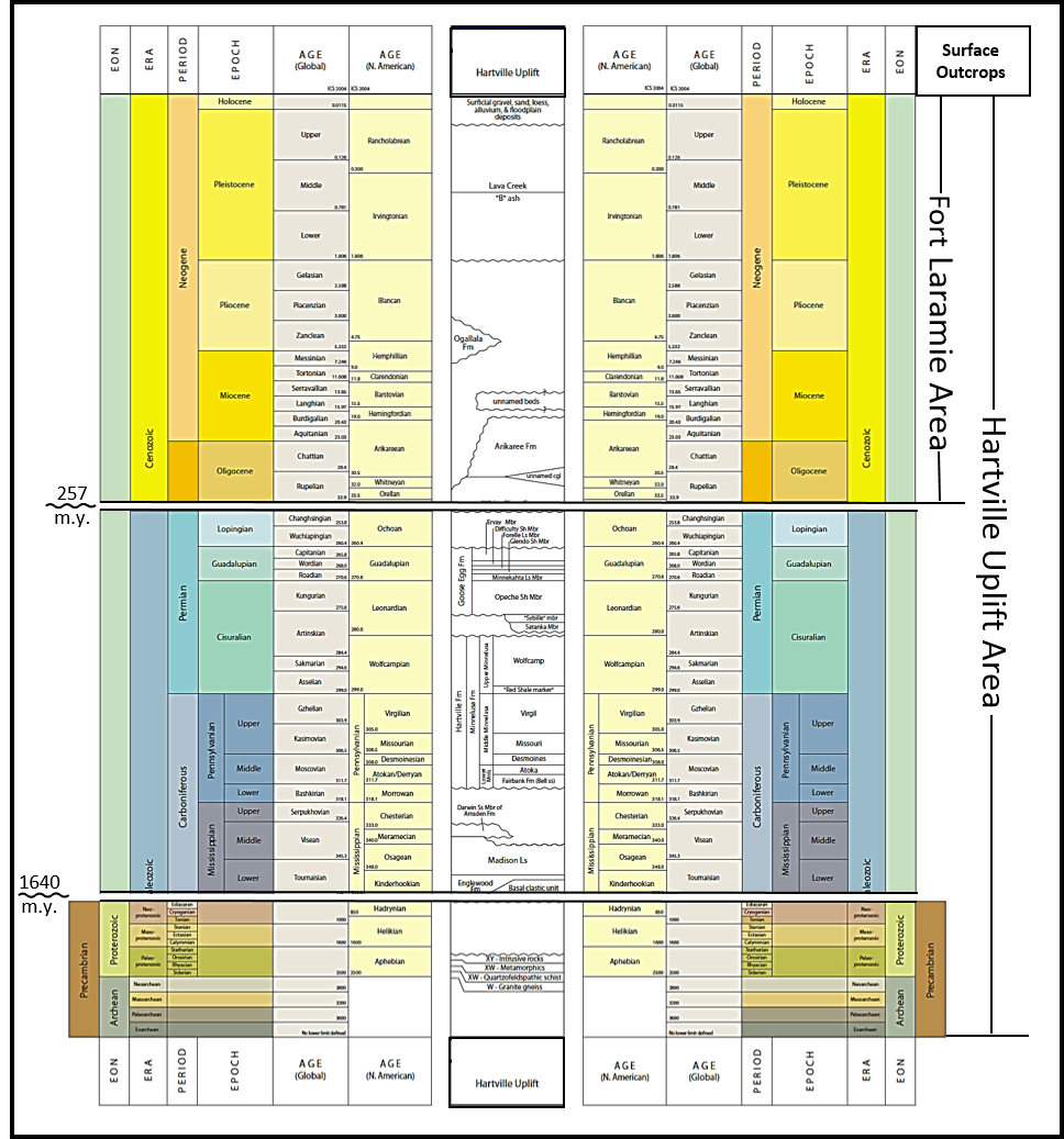
Stratigraphic column for rocks exposed in the Fort Laramie-Hartville Uplift area. Time gaps are indicated on left hand side of chart by wavy line with approximate duration labelled in millions of years (m.y.).
Image: After Cardinal, D., (Lead Chair), 2014, Stratigraphic Nomenclature Chart: Wyoming Geological Association, Stratigraphic Chart Committee, Chart No. 10.
Image: After Cardinal, D., (Lead Chair), 2014, Stratigraphic Nomenclature Chart: Wyoming Geological Association, Stratigraphic Chart Committee, Chart No. 10.
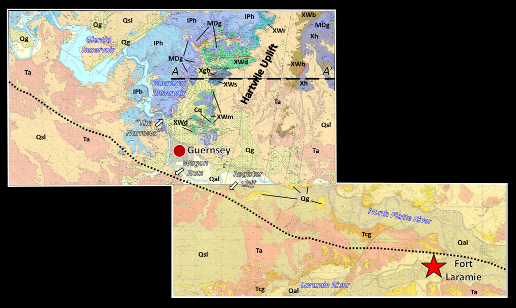
Geologic Map of the Fort Laramie-Hartville Uplift area. Emigrant trail shown by black dotted line. The trail diverts west of the North Platte to avoid “the Narrows” canyon where the river cuts through uplifted Paleozoic rocks that are today flooded by the Guernsey and Glendo reservoirs. Geologic code: Qal: Quaternary alluvial; Qsl: Quaternary silty loess; Qg: Quaternary gravel; Ta: Tertiary Arikaree Fm; Tcg: Tertiary conglomerate; IPh: Pennsylvanian Hartville Fm; MDg: Mississippian/Devonian Guernsey Fm; Cg: Cambrian quartzite; Xh: Early Proterozoic Haystack Granite; Xgb: Early Proterozoic metagabbro; XWb: Early Proterozoic-Late Archean Whalen Group quartzofeldspathic schist (east of Wheatland fault system); XWd: Early Proterozoic-Late Archean Whalen Group metadolomite; XWm: Early Proterozoic-Late Archean Whalen Group metabasalt; XWs: Early Proterozoic-Late Archean Whalen Group quartzofeldspathic schist (west of Wheatland fault system).
Image: After Harris, R.E., McLaughin, J.F., and Jones, R.W., 2006, Geologic map of the Guernsey Reservoir quadrangle, Platte County, Wyoming: Wyoming State Geological Survey Map Series 69, scale 1:24,000; http://sales.wsgs.wyo.gov/geologic-map-of-the-guernsey-reservoir-quadrangle-platte-county-wyoming-2006/; Harris, R.E., McLaughin, J.F., and Jones, R.W., 2005, Geologic map of the Guernsey quadrangle, Platte and Goshen counties, Wyoming: Wyoming State Geological Survey Map Series 68, scale 1:24,000; http://sales.wsgs.wyo.gov/geologic-map-of-the-guernsey-quadrangle-platte-and-goshen-counties-wyoming-2005/; McGrew, L.WS., 1963, Geology of the Fort Laramie area, Platte and Goshen Counties, Wyoming: U.S. Geological Survey Bulletin 1141-F, Plate 1; https://pubs.usgs.gov/bul/1141f/plate-1.pdf
Image: After Harris, R.E., McLaughin, J.F., and Jones, R.W., 2006, Geologic map of the Guernsey Reservoir quadrangle, Platte County, Wyoming: Wyoming State Geological Survey Map Series 69, scale 1:24,000; http://sales.wsgs.wyo.gov/geologic-map-of-the-guernsey-reservoir-quadrangle-platte-county-wyoming-2006/; Harris, R.E., McLaughin, J.F., and Jones, R.W., 2005, Geologic map of the Guernsey quadrangle, Platte and Goshen counties, Wyoming: Wyoming State Geological Survey Map Series 68, scale 1:24,000; http://sales.wsgs.wyo.gov/geologic-map-of-the-guernsey-quadrangle-platte-and-goshen-counties-wyoming-2005/; McGrew, L.WS., 1963, Geology of the Fort Laramie area, Platte and Goshen Counties, Wyoming: U.S. Geological Survey Bulletin 1141-F, Plate 1; https://pubs.usgs.gov/bul/1141f/plate-1.pdf
Structural cross section A-A’ through the Hartville Uplift.
Image: After Harris, R.E., McLaughin, J.F., and Jones, R.W., 2005, Geologic map of the Guernsey quadrangle, Platte and Goshen counties, Wyoming: Wyoming State Geological Survey Map Series 68, scale 1:24,000; http://www.wsgs.wyo.gov/products/wsgs-2005-ms-68.pdf
Image: After Harris, R.E., McLaughin, J.F., and Jones, R.W., 2005, Geologic map of the Guernsey quadrangle, Platte and Goshen counties, Wyoming: Wyoming State Geological Survey Map Series 68, scale 1:24,000; http://www.wsgs.wyo.gov/products/wsgs-2005-ms-68.pdf
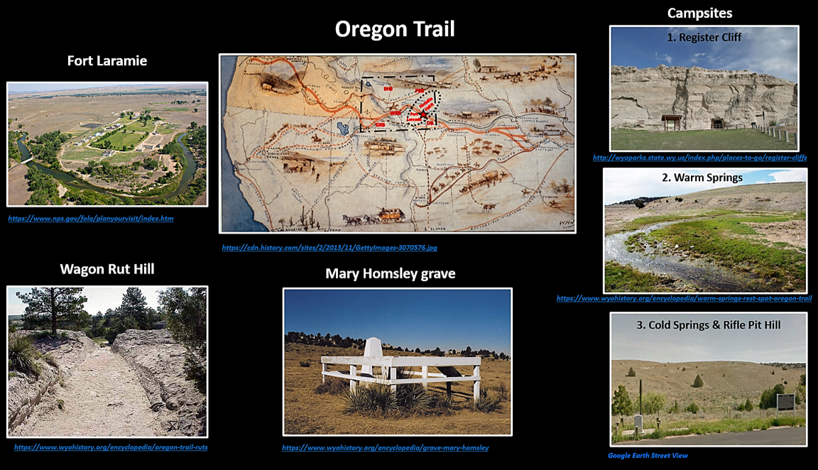
One day’s journey north of the fort, travelers generally chose one of three campsites. The first was located at the base of a cliff near the river. Here they inscribed their names on what would be called Register Cliff. The second site, Warm Springs, provided a hot spring for travelers that was sometimes called the “Emigrants’ laundry tub.” The springs emerged from a limestone bed in the Hartville Formation. The area was sometimes called “lime kiln spring” due to the Fort Laramie soldiers used the location for heating crushed limestone to make quicklime for construction projects. The third site at Cold springs was the farthest campsite along the trail. It was located next to a rock quarry in the Pennsylvanian Hartville Formation that provided stone and lime to Fort Laramie. The “lime kiln springs” operations were relocated to this site. The soldiers constructed five rifle pits to protect the quarry and emigrants, hence the name “Rifle Pit hill.”
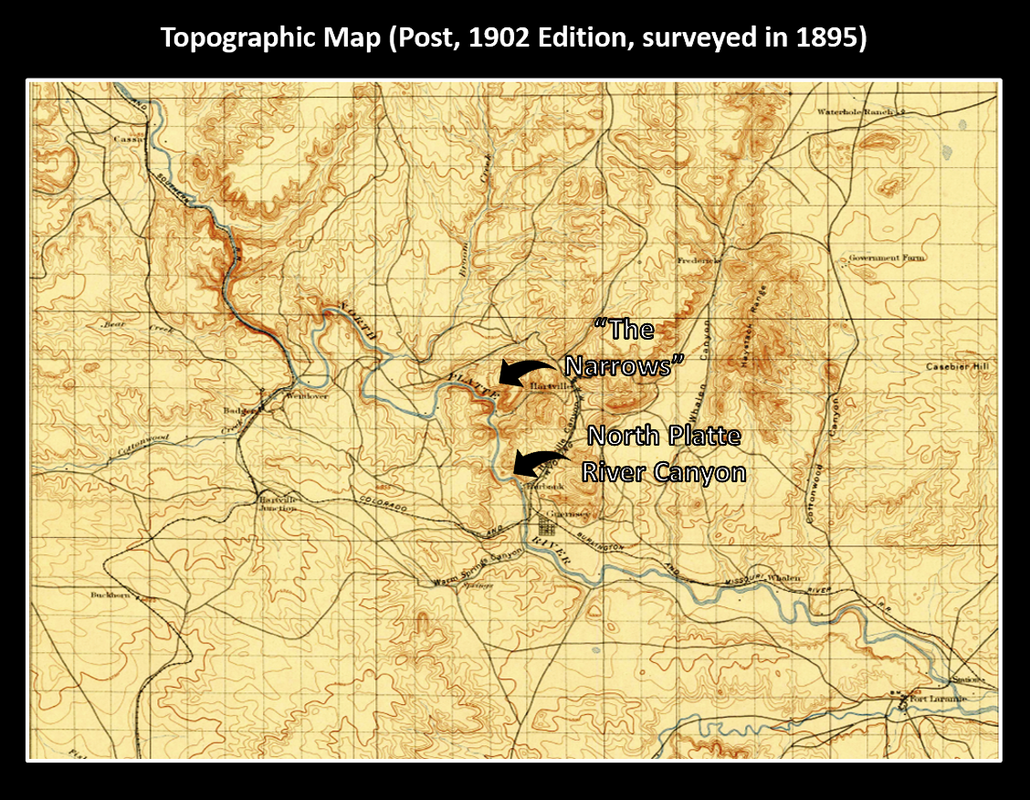
Geology controlled the immigrants route from Fort Laramie as they moved away from marshy ground near the river and the rugged canyon cut through hard Paleozoic rocks on the northwest flank of the Hartville Uplift. “The Narrows” of the North Platte River are four miles north of present day Guernsey. The immigrants traveled instead through ravines and hilly country where their wagons cut as much as five feet into the Miocene Arikaree Sandstone (Wagon Rut Hill). The “ruts” are a state historical site and a National Historical Landmark (Smithsonian number 48PA80) located in thewest half of section 2, Township 26 North, Range 66 West.
Geology controlled the immigrants route from Fort Laramie as they moved away from marshy ground near the river and the rugged canyon cut through hard Paleozoic rocks on the northwest flank of the Hartville Uplift. “The Narrows” of the North Platte River are four miles north of present day Guernsey. The immigrants traveled instead through ravines and hilly country where their wagons cut as much as five feet into the Miocene Arikaree Sandstone (Wagon Rut Hill). The “ruts” are a state historical site and a National Historical Landmark (Smithsonian number 48PA80) located in thewest half of section 2, Township 26 North, Range 66 West.
Topography along the North Platte River prior to Guernsey and Glendo dams and reservoirs.
Image: Post, W.S.T., 1903, The Hartville Folio: U.S. Geological Survey Geologic Folio No. 91, Topographic Map;https://pubs.er.usgs.gov/publication/gf91
Image: Post, W.S.T., 1903, The Hartville Folio: U.S. Geological Survey Geologic Folio No. 91, Topographic Map;https://pubs.er.usgs.gov/publication/gf91
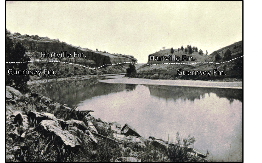
Canyon of the North Platte River near Fairbank. The basal sandstone of the Pennsylvania Hartville Formation unconformably rests on karsted surface of the Mississippian Guernsey Formation. The unconformity is shown by white dashed line.
Image: Smith, W.S.T., 1903, The Hartville Folio: U.S. Geological Survey Geologic Folio No. 91, Illustration Sheet, Fig. 4;https://pubs.er.usgs.gov/publication/gf91
Image: Smith, W.S.T., 1903, The Hartville Folio: U.S. Geological Survey Geologic Folio No. 91, Illustration Sheet, Fig. 4;https://pubs.er.usgs.gov/publication/gf91
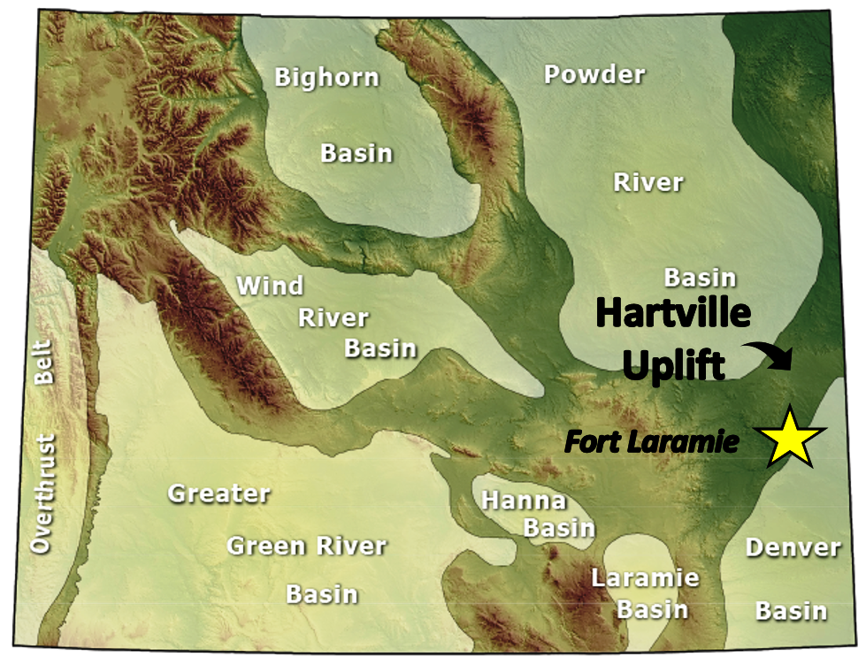
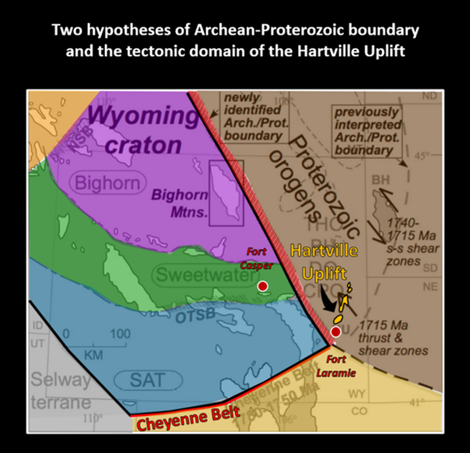
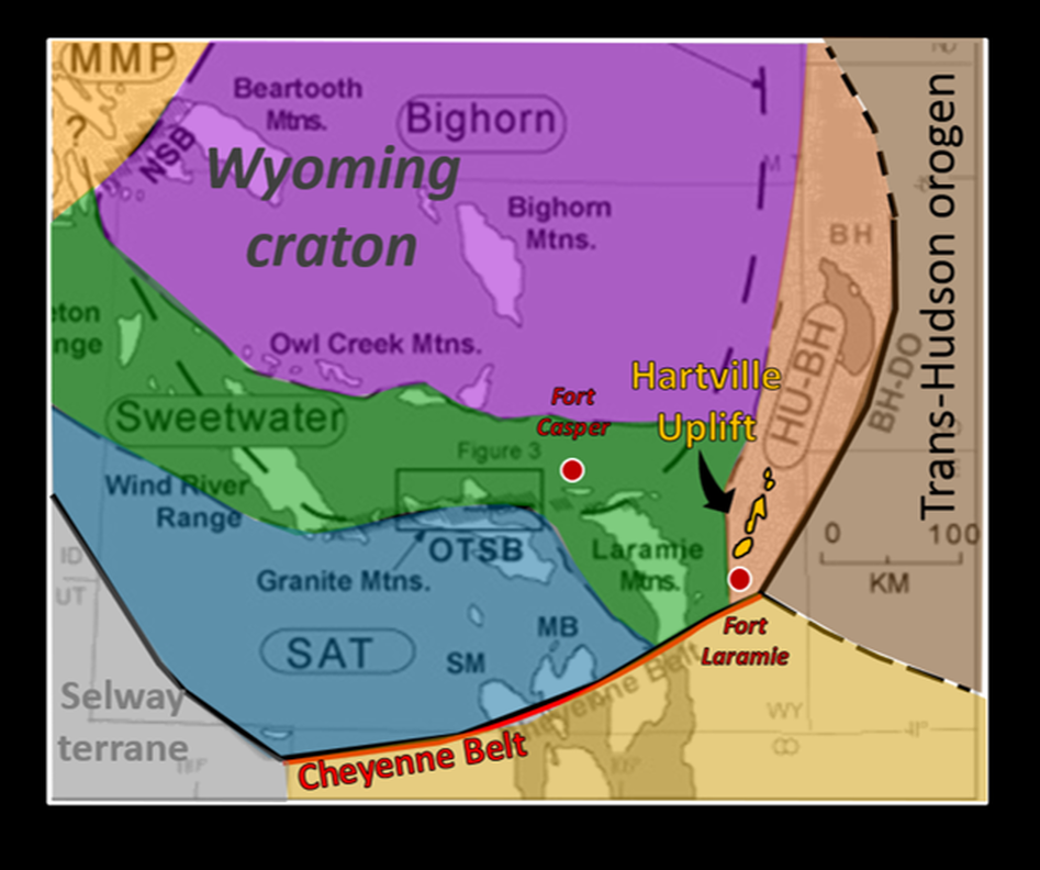
The Hartville Uplift emerges from the Great Plains as a geographic landmark along the Emigrant trails that marked a change in landscape ahead. The emigrants had no idea that they were passing a tectonic triple junction between two Archean cratons and a Proterozoic terrane. The former was a continent-continent collision called the Trans-Hudson Orogen that created mountains as big as the Himalayas that would have dwarfed the current Rockies. To the south, an island arc terrane approached by south dipping subduction and sutured itself to North America. The Cheyenne Belt marks this tectonic front at the southern margin of the assembled Archean cratons and the intervening orogenic zone. These ancient peaks had been eroded to their roots long before the immigrants passed
Geographic location of the Hartville Uplift separating the Powder River basin from the Denver basin. Location of Fort Laramie shown by star.
Image: Oil & Gas Basins map: Wyoming State Geological Survey; http://www.wsgs.wyo.gov/energy/oil-gas-basins
Image: Oil & Gas Basins map: Wyoming State Geological Survey; http://www.wsgs.wyo.gov/energy/oil-gas-basins
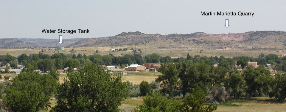
North view of Hartville Uplift at Guernsey, Wyoming. Area near the blue-green water storage tank is Camp Guernsey State Military Reservation. Martin Marietta quarry on the right skyline produces limestone, dolomite, quartzite, basalt, and sandstone from the Paleozoic Hartville and Guernsey Formations and the Early Proterozoic-Late Archean Whalen Group.
Image: Webring, M.W., Kucks, R.P., and Abraham, J.D., 2004, Gravity Study of the Guernsey Landfill Site, Guernsey, Wyoming: U.S. Geological Survey Open-File Report 2004-1383; https://pubs.usgs.gov/of/2004/1383/OF2004-1383_508.pdf
Image: Webring, M.W., Kucks, R.P., and Abraham, J.D., 2004, Gravity Study of the Guernsey Landfill Site, Guernsey, Wyoming: U.S. Geological Survey Open-File Report 2004-1383; https://pubs.usgs.gov/of/2004/1383/OF2004-1383_508.pdf
Regional tectonic maps showing the two hypotheses for the Archean-Protozoic boundary at the margin of the Wyoming Craton (black line surrounded colored subprovinces). Definitive basement outcrops are not exposed. Both hypotheses rely on interpretation of geophysical data. The tectonic domain of the Hartville Uplift is either: 1) part of the Trans-Hudson orogeny (2.2-1.84 Ga) based on tomographic models, seismic reflection data, and gravity and magnetic models (top), or 2) located in the southeastern corner of the Wyoming Craton based on an aeromagnetic linear anomaly (bottom). The Cheyenne Belt suture of the Central Plains orogen (1.78-1.64 Ga) is located south of the uplift in both interpretations.
Image; Left: After Worthington, L. L., K. C. Miller, E. A. Erslev, M. L. Anderson, K. R. Chamberlain, A. F. Sheehan, W. L. Yeck, S. H. Harder, and C. S. Siddoway(2016), Crustal structure of the Bighorn Mountains region: Precambrian influence on Laramide shortening and uplift in north-central Wyoming, Tectonics, 35, Fig. 22, p. 230; http://onlinelibrary.wiley.com/doi/10.1002/2015TC003840/epdf; Right: Chamberlain, K.R. and Mueller, P.A., 2007, Chapter 6.3 Oldest Rocks of the Wyoming Craton: Developments in Precambrian Geology, Vol. 15.
Image; Left: After Worthington, L. L., K. C. Miller, E. A. Erslev, M. L. Anderson, K. R. Chamberlain, A. F. Sheehan, W. L. Yeck, S. H. Harder, and C. S. Siddoway(2016), Crustal structure of the Bighorn Mountains region: Precambrian influence on Laramide shortening and uplift in north-central Wyoming, Tectonics, 35, Fig. 22, p. 230; http://onlinelibrary.wiley.com/doi/10.1002/2015TC003840/epdf; Right: Chamberlain, K.R. and Mueller, P.A., 2007, Chapter 6.3 Oldest Rocks of the Wyoming Craton: Developments in Precambrian Geology, Vol. 15.
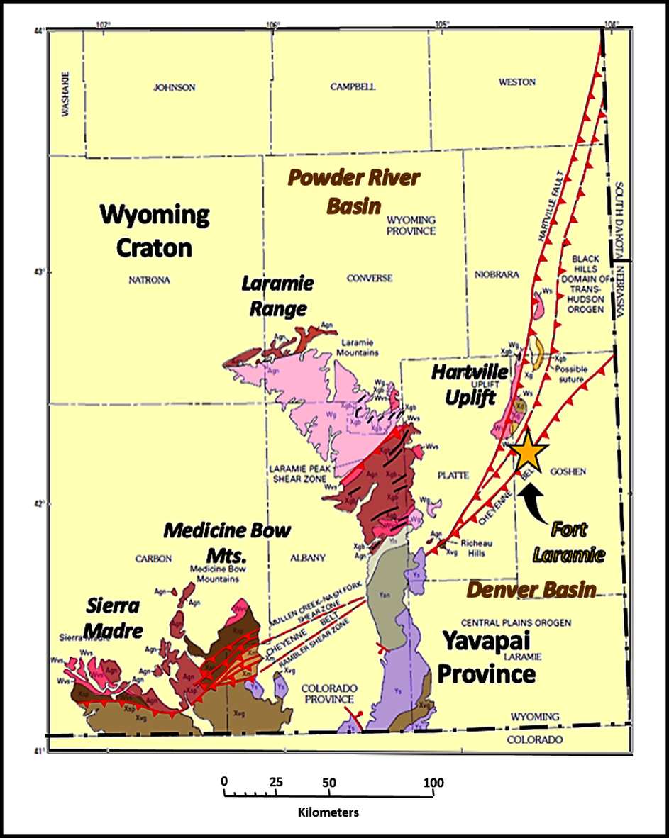
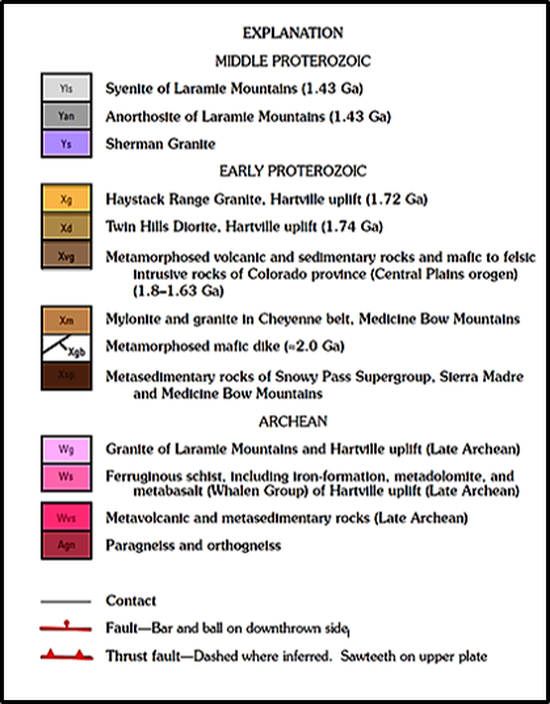
Geologic-Tectonic Map of southeastern Wyoming showing Precambrian rock units and major fault zones.
Image: After Day, W.C., Sims, P.K., Snyder, G.L., Wilson, A.B. andKlein, T.L. with a section onGeochronology byPeterman, Z. E. Futa, K. andZartman, R.E., Geologic Map of Precambrian Rocks, Rawhide Buttes West Quadrangle and Part of Rawhide Buttes East Quadrangle, Hartville Uplift, Goshen and Niobrara Counties, Wyoming: U.S. Geological Survey Geologic Investigations Series I–2635, Fig. 1, p. 14-15; https://pubs.usgs.gov/imap/i-2635/i-2635jacketpo.pdf
Image: After Day, W.C., Sims, P.K., Snyder, G.L., Wilson, A.B. andKlein, T.L. with a section onGeochronology byPeterman, Z. E. Futa, K. andZartman, R.E., Geologic Map of Precambrian Rocks, Rawhide Buttes West Quadrangle and Part of Rawhide Buttes East Quadrangle, Hartville Uplift, Goshen and Niobrara Counties, Wyoming: U.S. Geological Survey Geologic Investigations Series I–2635, Fig. 1, p. 14-15; https://pubs.usgs.gov/imap/i-2635/i-2635jacketpo.pdf
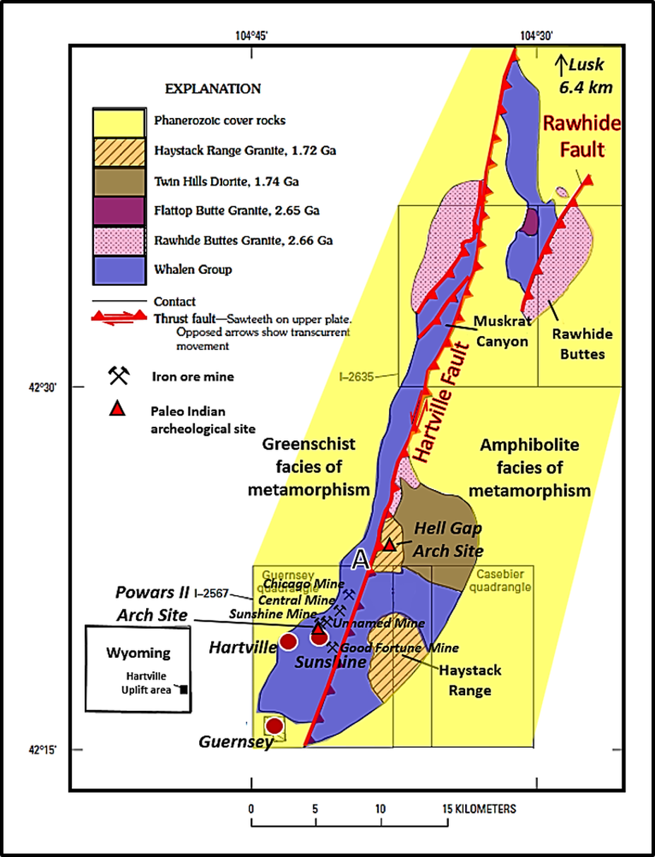
The Hartville Uplift is an elongated, north-northeastward oriented, Laramide-age (70-50 Ma). broad domal arch. It extends approximately 45 miles between Guernsey and Lusk, Wyoming and is 15 miles wide. The structure is elevated by a high angle fault on the east side of the arch. Relief rises 1,500 feet above the surrounding plains. Erosion has exposed a core of Precambrian metasedimentary and metavolcanic rocks, and Paleozoic sedimentary units that dip away from the core. Areas of flat lying Tertiary and Quaternary units are scattered throughout the uplift and valleys.
Simplified geology of Precambrian rocks of Hartville uplift, southeastern Wyoming. Location of published geologic maps shown for reference. A, Hartville fault exposed near Hell Gap. Location of iron ore mines and Paleo Indian archeological sites are shown.
Image: After Day, W.C., Sims, P.K., Snyder, G.L., Wilson, A.B. andKlein, T.L. with a section onGeochronology byPeterman, Z. E. Futa, K. andZartman, R.E., Geologic Map of Precambrian Rocks, Rawhide Buttes West Quadrangle and Part of Rawhide Buttes East Quadrangle, Hartville Uplift, Goshen and Niobrara Counties, Wyoming: U.S. Geological Survey Geologic Investigations Series I–2635, Fig. 2, p. 16; https://pubs.usgs.gov/imap/i-2635/
Image: After Day, W.C., Sims, P.K., Snyder, G.L., Wilson, A.B. andKlein, T.L. with a section onGeochronology byPeterman, Z. E. Futa, K. andZartman, R.E., Geologic Map of Precambrian Rocks, Rawhide Buttes West Quadrangle and Part of Rawhide Buttes East Quadrangle, Hartville Uplift, Goshen and Niobrara Counties, Wyoming: U.S. Geological Survey Geologic Investigations Series I–2635, Fig. 2, p. 16; https://pubs.usgs.gov/imap/i-2635/
Hartville Uplift Mining
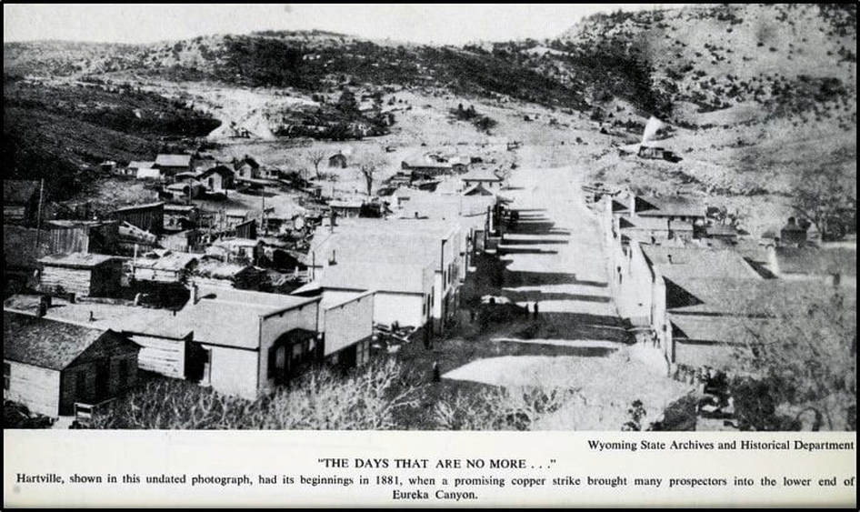
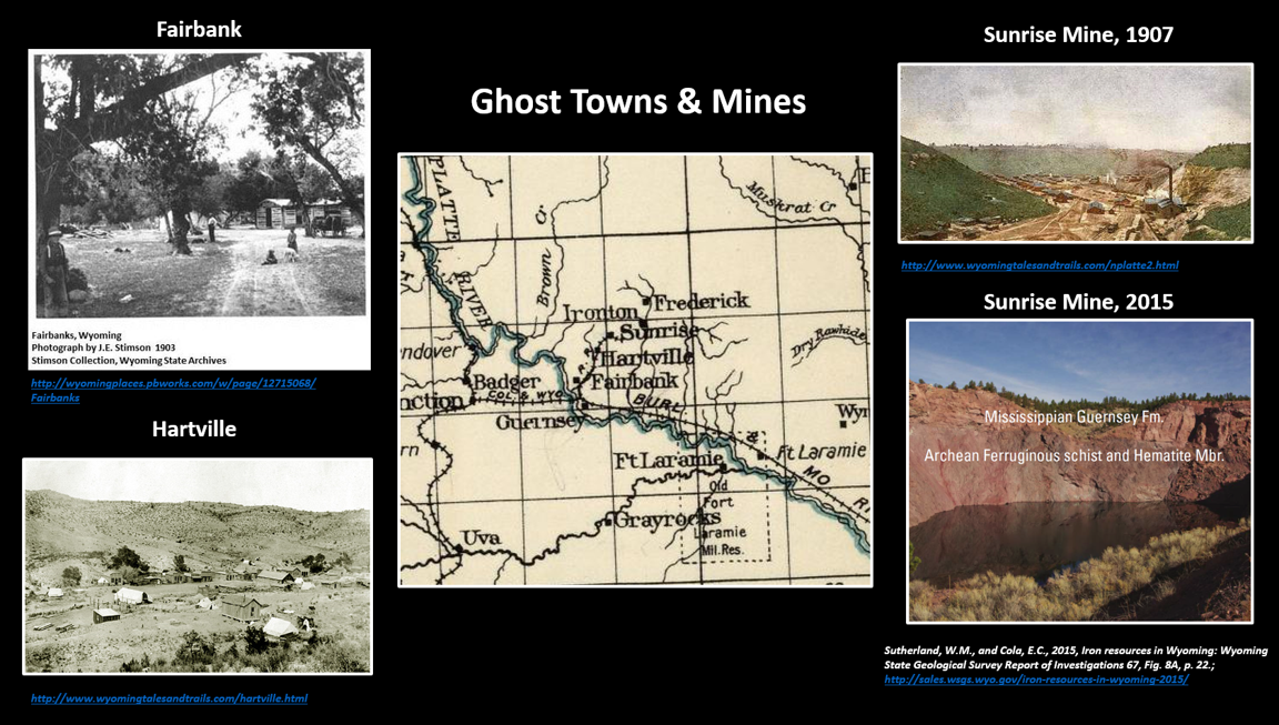
Mining brought people into the Hartville Uplift area. Prospectors, often soldiers from Fort Laramie, explored the hills for precious metals. In the 1870s a mining camp was established in the narrow Eureka Canyon centered near copper ore claims. The town was formally established in 1884 and named after Colonel Virling Hart, the commander at Fort Laramie, who owned the Keystone claim in the area and opened the first copper mine. Hartville is the oldest “still-in-existence” incorporated town in Wyoming. The only public facility offered by the newly incorporated town was a hitching post for the “Saturday night crowd” (Mellinger, 1971).
Early Hartville, Wyoming. Note the false front architecture on almost every building on the main street. Left side hills are Archean Whalen Group quartzofeldspathic schist, unconformably overlain by Mississippian Guernsey Formation. The right hand hills are Archean Whalen Group metadolomite, also unconformably overlain by Mississippian Guernsey Formation.
Image: Mellinger, C.J., 1971, Frontier Camp to Small Town, A Study of Community Development: Annals of Wyoming, Vol. 43, No. 2.
Image: Mellinger, C.J., 1971, Frontier Camp to Small Town, A Study of Community Development: Annals of Wyoming, Vol. 43, No. 2.
Hartville Uplift Copper
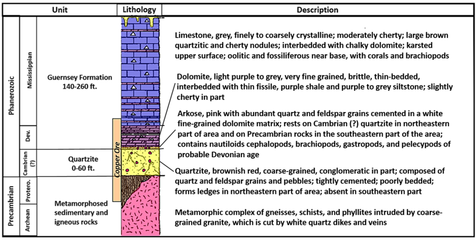
The copper ore was found concentrated near the contact of the Mississippian/Devonian Guernsy Limestone (MDg, aka Madison Formation) and the Precambrian rocks. The ore is a stratabound deposit that was not formed by igneous processes. In 2003, the U.S. Geological Survey compiled a database of stratabound deposits and identified the requirements for formation: 1) an oxidized source rock (not identified), 2) a source of brines to mobilize copper (evaporite beds in the Guernsey Limestone), 3) a source of reduced fluid to precipitate copper (carbonate rock of Guernsey), and 4) conditions favorable for fluid mixing (porous and permeable host bed). The main Hartville area ore types are malachite, chrysocolla, and chalcocite. Copper was found in three types of deposits, from most common to least: 1) Lenticular and wedge-shaped bodies extending fifty feet into the Precambrian metamorphosed rocks. 2) Bedded deposits of the Guernsey basal Arkosic sandstone, and 3) Fissure veins, generally within 20 feet of the contact. Ore was actively mined from 1885 to 1887 when the ore was depleted. About 5 million pounds of copper ore were extracted from several mines, the most important of which was the Sunrise. Market price and transportation expense accelerated the end of copper mining.
Generalized lithologic column of the Guernsey Formation to the Upper Precambrian rocks that were host to copper ore deposits.
Image: After Denson, N.M. and Botinelly, T., 1949, Geology of the Hartville Uplift, Eastern Wyoming: U.S. Geological Survey Oil and Gas Investigations Preliminary Map 102 (in two sheets) Sheet 2; https://pubs.er.usgs.gov/publication/om102
Image: After Denson, N.M. and Botinelly, T., 1949, Geology of the Hartville Uplift, Eastern Wyoming: U.S. Geological Survey Oil and Gas Investigations Preliminary Map 102 (in two sheets) Sheet 2; https://pubs.er.usgs.gov/publication/om102
Copper ores mined in the Hartville area. Malachite (Cu2(CO3)(OH)2) forms at shallow depths, precipitating from solutions in fractures of porous rock. Chrysocolla ((Cu,Al)2H2Si2O5(OH)4•n(H2O)) is also a secondary oxide that occurs with malachite. Chalcocite (Cu2S) is a higher-grade ore and occurs below the other ores but near the oxidized source of the ore. Minor amounts of Azurite (Cu3(CO3)2(OH)2)and native copper (Cu) were also produced.
Image: Malachite: http://www.jewelrycult.com/gemstones/malachite; Chrysocolla: https://upload.wikimedia.org/wikipedia/commons/e/ee/Chrysocolla-230109.jpg;
Chalacite: https://upload.wikimedia.org/wikipedia/commons/2/2d/Chalcocite-139809.jpg
Image: Malachite: http://www.jewelrycult.com/gemstones/malachite; Chrysocolla: https://upload.wikimedia.org/wikipedia/commons/e/ee/Chrysocolla-230109.jpg;
Chalacite: https://upload.wikimedia.org/wikipedia/commons/2/2d/Chalcocite-139809.jpg
Hartville Uplift Iron
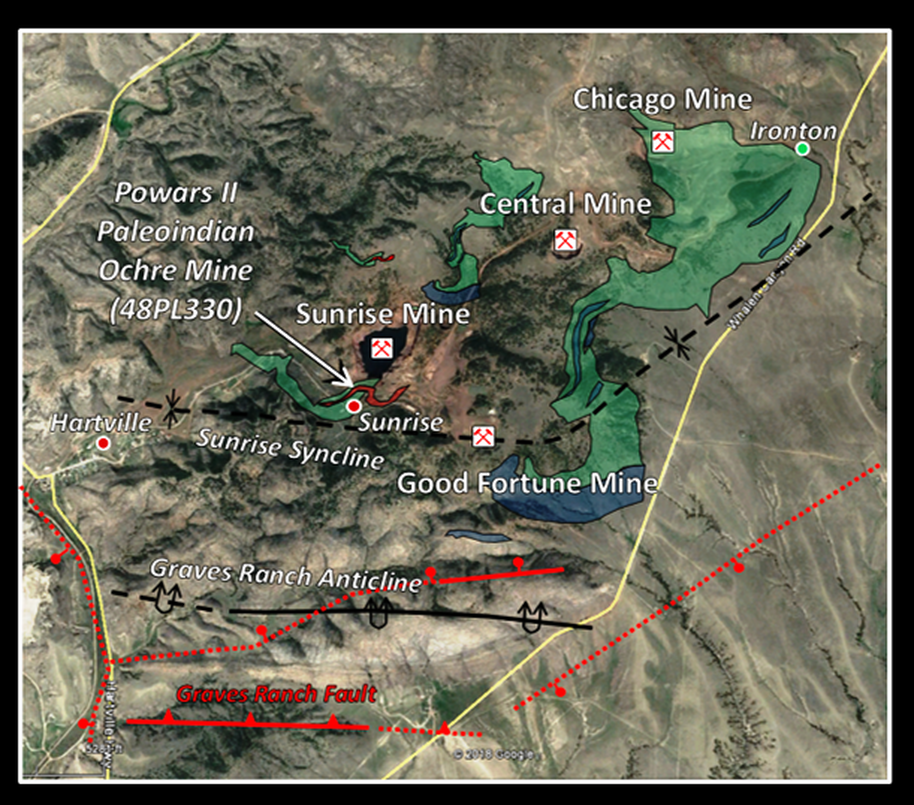
Iron ore was first produced in the Sunrise mine in 1889, just as the copper mining ceased. Hartville community boosters envisioned their town becoming the “Pittsburg of the West” (Iron Gazette, Hartville Nov. 17, 1899). The iron ore came from four mines located on the western downthrown block of the Hartville Fault. They were the Central, Chicago, Good Fortune and Sunrise Mines. The communities of Hartville, Sunrise, and Ironton near the mines, housed the miners. Guernsey was the railroad transport hub. The Colorado Fuel & Iron Company, which was owned and controlled by George Jay Gould and J.D. Rockefeller, began leasing in the area in 1889. They purchased the entire upper canyon property in 1904 and oversaw all aspects of mining operations and the miner’s lives. Sunrise was a non-union, dry, company town. The Colorado Fuel and Iron Company owned and operated the train (Hartville Junction to Sunrise), rented the housing, sold the food, clothes and merchandise, and ran the education program in their schools for the miner’s children.
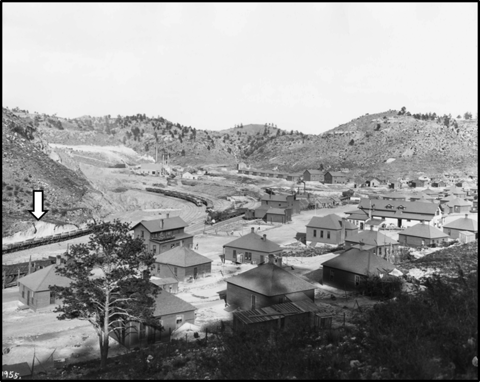
Northeast view of Sunrise, Wyoming, circa 1907. The hills expose Archean Whalen Group schist unconformably overlain by Mississippian Guernsey Formation. The mine pit is the left center of the image. Just to the left of the mine is the Powars II archeological site in the scarp above the ore cars (white arrow). The buildings are neat and tidy, befitting a model company town. Most of these buildings are now gone.
Image: Stimson, J.E., Photograph of Sunrise: Wyoming State Archives;http://uwdigital.uwyo.edu/islandora/object/wyu%3A3429/datastream/OBJ/view
Image: Stimson, J.E., Photograph of Sunrise: Wyoming State Archives;http://uwdigital.uwyo.edu/islandora/object/wyu%3A3429/datastream/OBJ/view
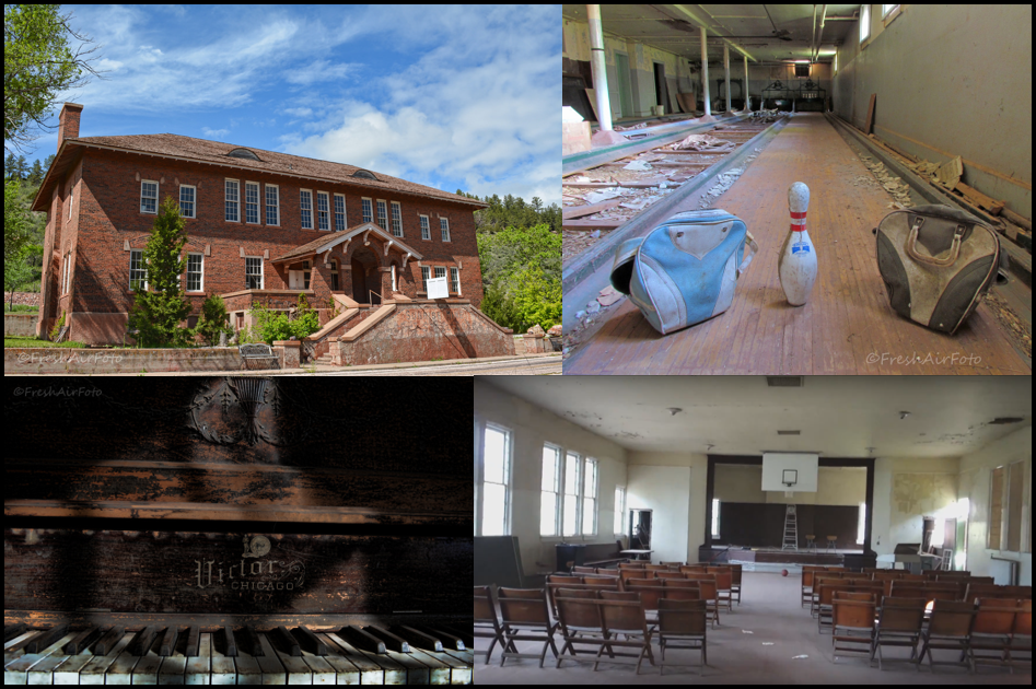
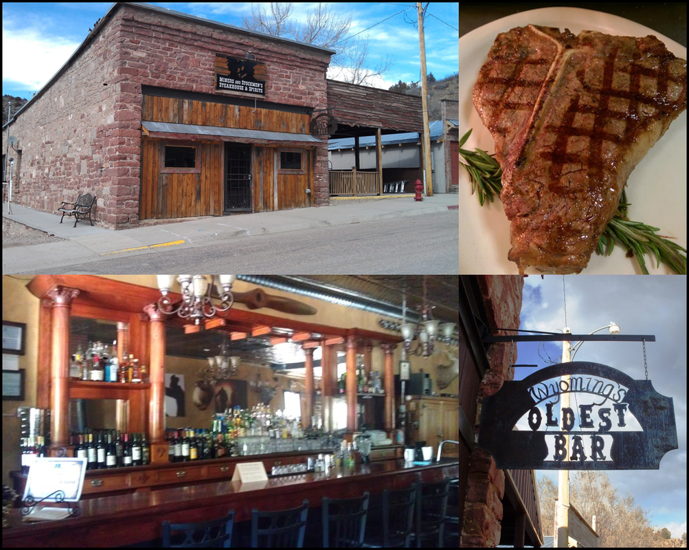
The town of Sunrise boasts that it is the home of the first YMCA in Wyoming. Besides the gym, the YMCA also featured a bowling alley, movie theater and dance hall. In contrast, Hartville hosts the oldest bar in Wyoming. The cherry wood back bar was hand carved in Germany and originally did service in the officer’s club at Fort Laramie in the 1860s. The Miners and Stockman’s Bar is also a steakhouse.
Sunrise YMCA, established 1917 during WWI.
Image: Building & piano: https://hiveminer.com/Tags/decay%2Cwyoming; Bowling alley: https://hiveminer.com/Tags/ruin,ymca/Recent; Stage: https://www.youtube.com/watch?v=D3MrtFT_usQ.
Image: Building & piano: https://hiveminer.com/Tags/decay%2Cwyoming; Bowling alley: https://hiveminer.com/Tags/ruin,ymca/Recent; Stage: https://www.youtube.com/watch?v=D3MrtFT_usQ.
Hartville Miners and Stockman’s Saloon and Steakhouse, established 1862 during the Civil War
Image: Bar & steak: https://www.facebook.com/MinersandStockmenssteakhouseandspirits/; Backbar: https://www.pinterest.com/pin/283515739019719834/; Sign: https://www.pinterest.com/pin/81064862021183838/.
Image: Bar & steak: https://www.facebook.com/MinersandStockmenssteakhouseandspirits/; Backbar: https://www.pinterest.com/pin/283515739019719834/; Sign: https://www.pinterest.com/pin/81064862021183838/.
Hartville Uplift iron district deposits exposed at the surface.
Image: Google Earth; Data: After Sutherland, W.M., and Cola, E.C., 2015, Iron resources in Wyoming: Wyoming State Geological Survey Report of Investigations 67, Fig. 7, p. 21; http://sales.wsgs.wyo.gov/iron-resources-in-wyoming-2015/
Image: Google Earth; Data: After Sutherland, W.M., and Cola, E.C., 2015, Iron resources in Wyoming: Wyoming State Geological Survey Report of Investigations 67, Fig. 7, p. 21; http://sales.wsgs.wyo.gov/iron-resources-in-wyoming-2015/
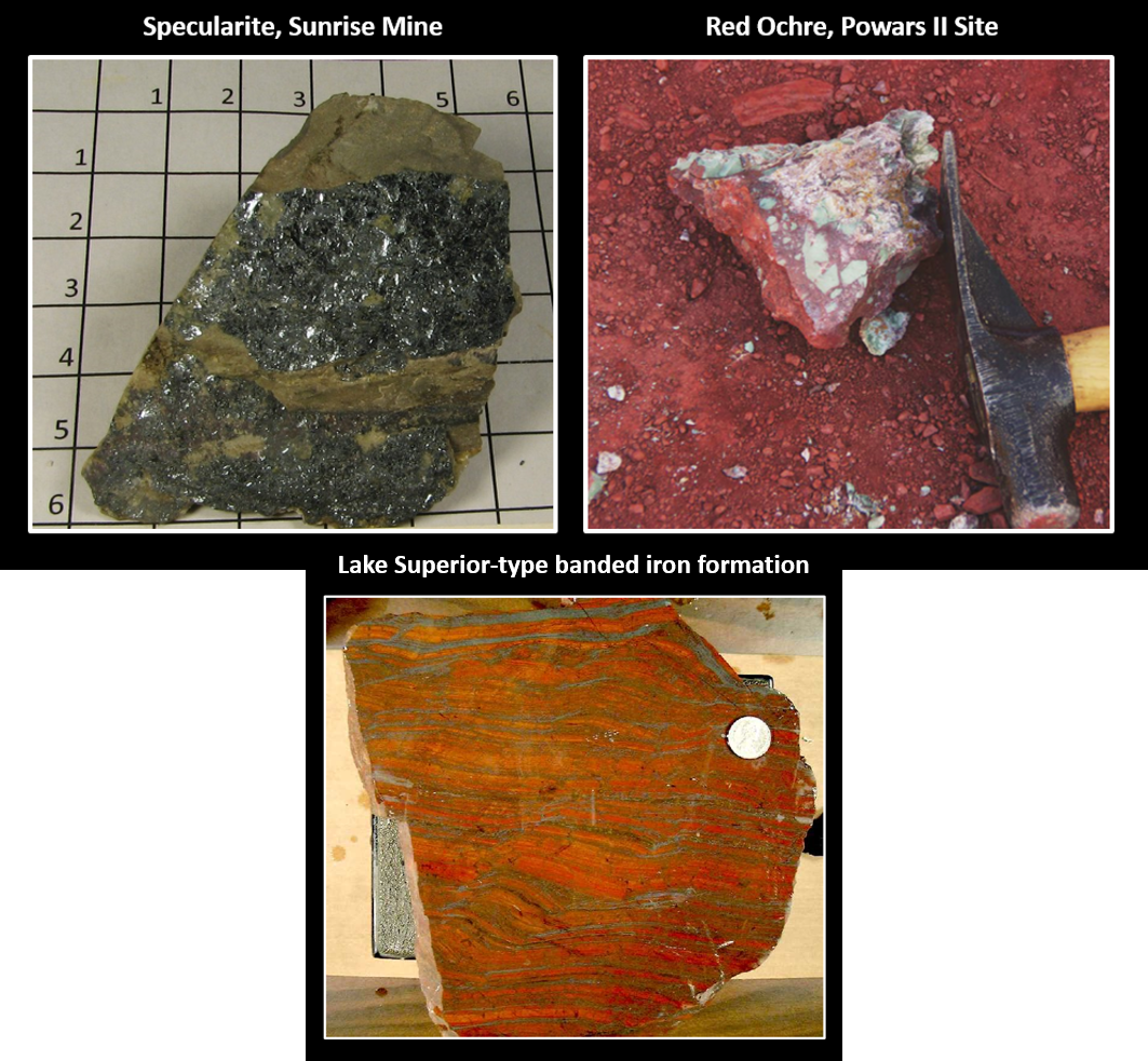
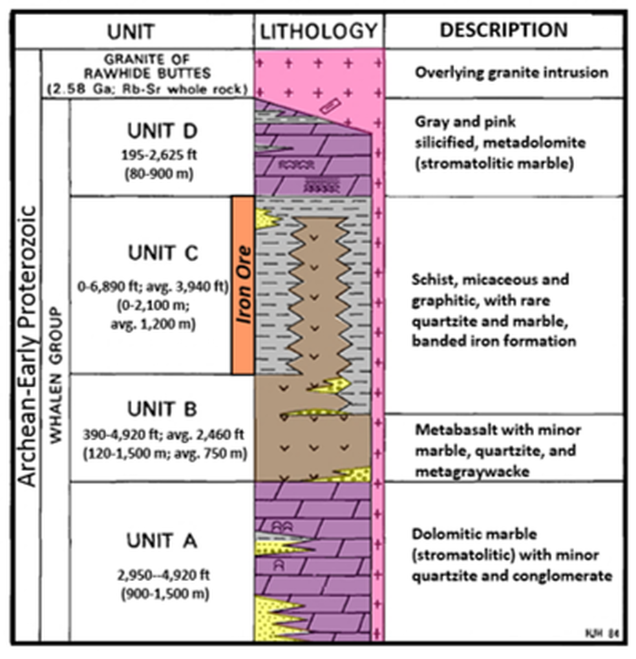
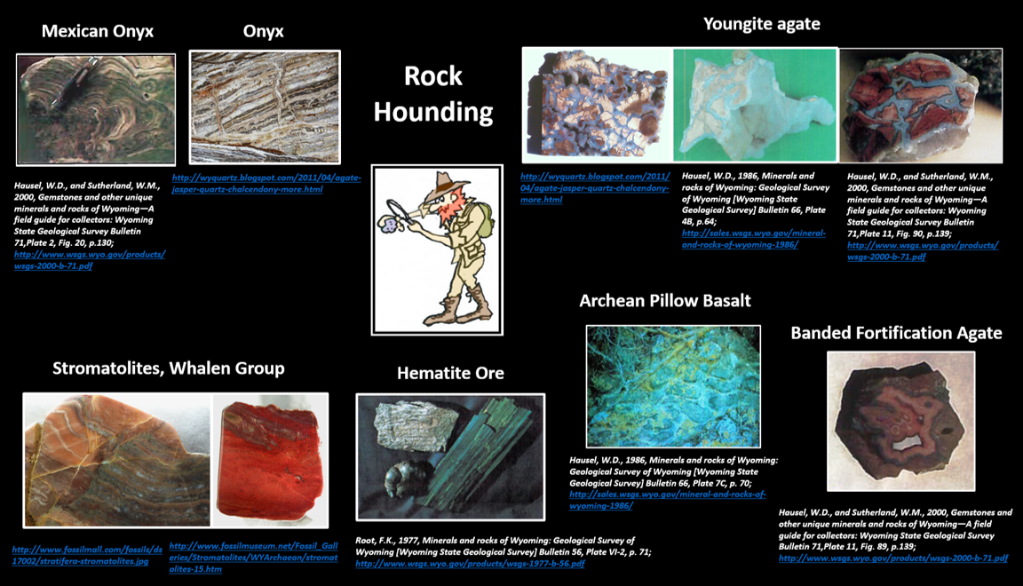
Two types of iron deposits are present in the Hartville Uplift: 1) hematite ore (specularite and red ochre, earthy hematite) and 2) Lake Superior-type banded iron formation, a shallow marine sedimentary rock. Both ores are concentrated in the Archean Whalen Group schist below an overlying metadolomite (dolomitic marble). The Whalen Group is a complex of metamorphosed basin sediments and volcanic rocks of island arc origin. They include metabasalt, metadolomite, banded iron formation, schist and quartzite. About 45 million tons of iron ore were produced between 1889-1980.
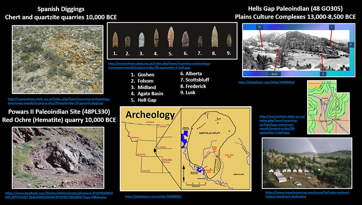
Archeological evidence shows that Paleoindians mined the Sunrise site for red ochre (anhydrous iron (III) oxide) and chert about 12,000 years ago. Numerous Clovis age artifacts have been recovered from the Powars II Paleoindian archeological site. That site was first found in the 1930s but was not rediscovered until 1986. The site is located across from the Sunrise YMCA building on a scarp face above the old railroad tracks.
Archeological evidence shows that Paleoindians mined the Sunrise site for red ochre (anhydrous iron (III) oxide) and chert about 12,000 years ago. Numerous Clovis age artifacts have been recovered from the Powars II Paleoindian archeological site. That site was first found in the 1930s but was not rediscovered until 1986. The site is located across from the Sunrise YMCA building on a scarp face above the old railroad tracks.
Iron ore types mined in the Sunrise Mine are: 1) specular hematite (variety with silvery, metallic, “mirror-like” crystals) (Fe2O3), 2) red ocher, by Plains Indians (anhydrous iron (III) oxide, Fe2O3), 3) banded iron formation (BIF). Lake Superior-type banded iron formation is a distinctive sedimentary rock with very laterally continuous layers of iron minerals alternating with silica (chert) deposits. Probably deposited on a shallow stable continental shelf within a narrow time range of precipitation (2.7-1.8 billion years ago). This time window is related to the oxygenation of earth’s atmosphere. The oxygen produced by cyanobacteria in the ocean was consumed by the iron in sea water to form hematite (Fe2O3). Once oxidized the iron fell to the sea floor producing an iron layer. The silica saturated oceans precipitated the chert layers. The modern ocean has abundant silica extracting organisms (diatoms, sponges, radiolarians) thus making it impossible for banded iron formation to form.
Image: Specularite: http://www.mwminerals.com/image/E/E1071-w.jpg; Red Ochre: Sutherland, W.M., and Cola, E.C., 2015, Iron resources in Wyoming: Wyoming State Geological Survey Report of Investigations 67, Fig. 8B, p. 22; http://sales.wsgs.wyo.gov/iron-resources-in-wyoming-2015/; Banded iron formation: https://instruct.uwo.ca/earth-sci/200a-001/archprotorig/dscf0228.jpg.
Image: Specularite: http://www.mwminerals.com/image/E/E1071-w.jpg; Red Ochre: Sutherland, W.M., and Cola, E.C., 2015, Iron resources in Wyoming: Wyoming State Geological Survey Report of Investigations 67, Fig. 8B, p. 22; http://sales.wsgs.wyo.gov/iron-resources-in-wyoming-2015/; Banded iron formation: https://instruct.uwo.ca/earth-sci/200a-001/archprotorig/dscf0228.jpg.
Generalized lithologic column of the Whalen Group in the Hartville Uplift.
Image: After Hofmann, H.J. and Snyder, G.L., 1985, Archean stromatolites from the Hartville Uplift, eastern Wyoming: Geological Society of America Bulletin, v. 96, Fig. 2, p. 843.
Image: After Hofmann, H.J. and Snyder, G.L., 1985, Archean stromatolites from the Hartville Uplift, eastern Wyoming: Geological Society of America Bulletin, v. 96, Fig. 2, p. 843.
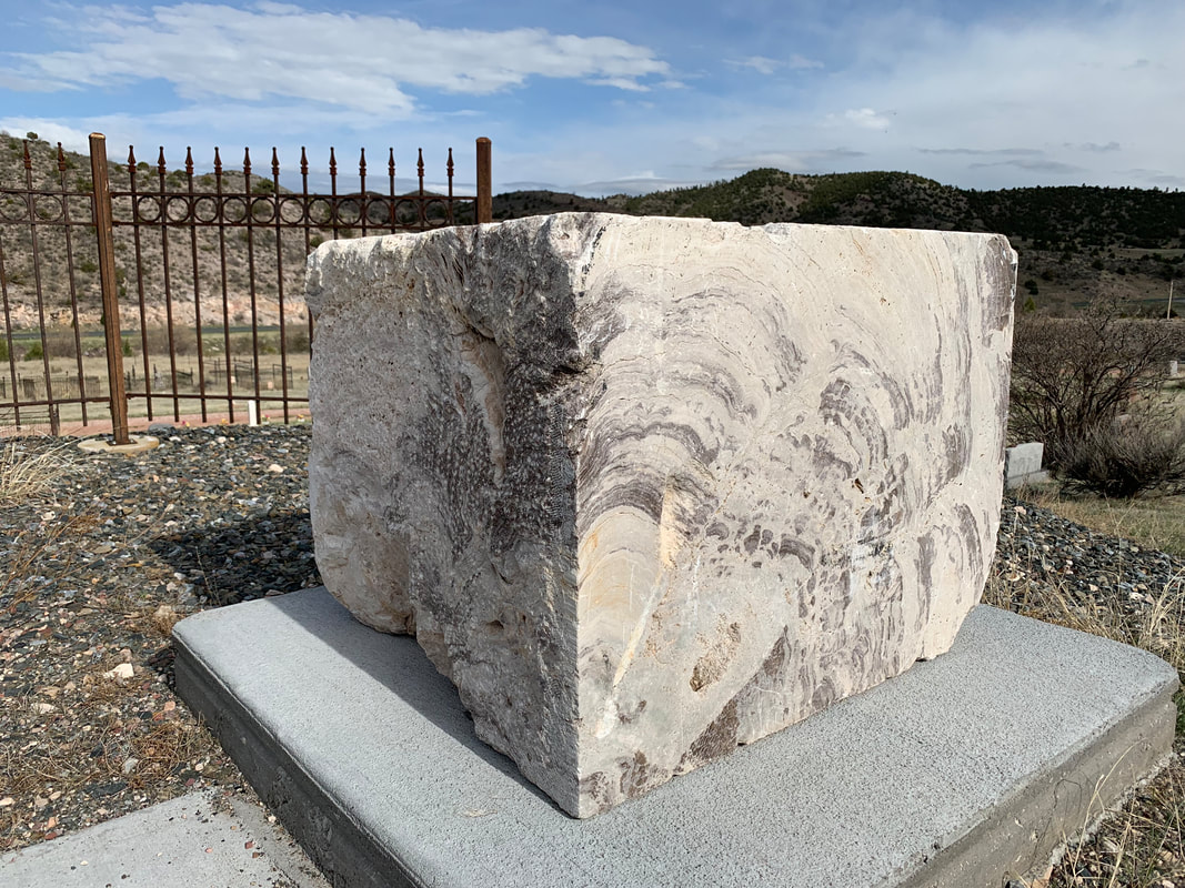
Archean Whalen Group block of stromatolite adjacent to flag pole at the Hartville Cemetery
Image by Mark Fisher
Image by Mark Fisher
The Whalen Group rocks were deposited in a deep marine basin adjacent to a volcanic arc and a nearby Archean cratonic margin. These units have undergone at least three episodes of Precambrian deformation (between 2.1-1.72 billion years ago) and two periods of metamorphism (2.1 and 1.82 billion years ago). They were sutured onto the craton during the Trans-Hudson tectonic event (2.1-1.8 billion years ago). Further deformation occurred during the attachment of the Yavapai Province along the Cheyenne Belt (1.78-1.76 million years ago) and doming from the post-tectonic intrusion of granitic bodies (1.72 billion years ago).
The Fort Laramie-Hartville Uplift area presents a landscape that lies at the confluence of myth and reality of the American west. It is also the geologic assembly site for ancient tectonic plates, ocean basins and volcanic arcs. Through it passed all the characters in Western movies, television shows and novels. Fur traders, explorers, scientists, prospectors, missionaries, soldiers, cowboys, Indians, emigrants, stockmen, farmers, highwaymen, rustlers, prostitutes, stage drivers, and pony express riders lived, died and are buried on this ground. The regional geology controlled the migration routes, access to water and forage, and provided ores to support the economics of mining towns.
Famous names like Stuart, La Ramee, Smith, Fitzpatrick, Bridger, Fremont, Carson, Campbell, Sublette, Donner, Parkman, Bonneville, Kearny and Young are all part of the story. La Ramee was a trapper who followed a stream into the mountains for the 1820 trapping season and disappeared. But his name (Laramie) was given to a fort, town, river, mountain peak, mountain range and a tectonic episode (Laramide) that created most of the mountains and basins in Wyoming, and in the Rocky Mountain states. All this geology and history awaits at a crossroads in the American West, in southeastern Wyoming.
Things-To-Do
The Colorado Geologic Survey has published a field guide to the Hartville Uplift area by Sims, P.K., Day, W.C., Snyder, G.L., Wilson, A.B., 1996, Precambrian Tectonics and Metallogeny of the Hartville Uplift, Wyoming: U.S. Geological Survey Open-File Report 96-4; https://www.researchgate.net/profile/Warren_Day/publication/267807319_e_BULLET_2_Precambrian_Tectonics_and_Metallogeny_of_the_Hartville_Uplift_Wyoming/links/54ec94450cf28f3e65344925/e-BULLET-2-Precambrian-Tectonics-and-Metallogeny-of-the-Hartville-Uplift-Wyoming.pdf (3.3 MB download)

The material on this page is copyrighted
