Geology of Wyoming
  • Home
    • Wow Factor
    • Geological Factor
    • Stratigraphic Column
    • Wyoming Links
    • About The Geologists
    • Contact Us
  • Map of GeoWyo Top Spots
  • Albany-Laramie Counties
    • Big Hollow
    • Como Bluff
    • Snowy Range Stromatolites
    • Sybille Canyon - WY Highway 34
    • Vedauwoo
    • Wyoming Diamonds
  • Big Horn County
    • Ancient River Channel & Sheep Mountain
    • Bighorn Canyon
    • Bighorn Mountain Byways Part I
    • Bighorn River Area Caves
    • Devil's Kitchen
    • Medicine Lodge Tensleep Sandstone
    • Red Gulch Alkali Backcountry Byway
    • Red Gulch Dinosaur Tracksite & Sundance Seaway
    • Shell Dinosaur Bone Beds
  • Campbell County
    • Pumpkin Buttes
  • Carbon County
    • Battle Pass Byway - WY Highway 70
    • Encampment & Sierra Madre Mtns
    • Freezeout Hills
    • Rawlins Uplift
    • Shirley Basin
  • Converse County
    • Ayres Natural Bridge
    • Douglas Crater Field
  • Crook County
    • Devils Tower & Black Hills
  • Fremont County
    • Gas Hills & Crooks Gap Uranium
    • Red Canyon
    • Sinks Canyon
    • South Pass
  • Goshen-Platte Counties
    • Fort Laramie & Hartville Uplift
    • Goshen Hole
  • Hot Springs County
    • Anchor Dam
    • Dinosaur Marbles
    • Thermopolis Hot Springs
    • Wind River Canyon Part 1
    • Wind River Canyon Part 2
  • Johnson County
    • Hole In The Wall & Red Wall Country
  • Laramie County
    • Cheyenne Tablelands and Gangplank
  • Lincoln County
    • Fossil Butte
    • Periodic Spring
  • Natrona County
    • Bessemer Bend
    • Casper Mountain
    • Ervay Basin
    • Granite Mountains
    • Hells Half Acre
    • Rattlesnake Hills
  • Niobrara County
    • Lusk Area
  • Park County
    • Absaroka Volcanic Province
    • Beartooth Highway
    • Buffalo Bill Dam & Rattlesnake Mtn.
    • Clarks Fork Canyon
    • Cody Hydrothermal System
    • Dead Indian Hill
    • The Great Unconformity
    • Heart Mountain
    • Kirwin
    • Oregon Basin Oil Field
    • McCullough Peaks
    • Polecat Bench & PETM
    • Sunlight Basin
    • Tatman Mountain & Squaw Peaks
  • Sheridan County
    • Bighorn Mountain Byways Part II
  • Southeast Wyoming
    • North Platte River: One Dammed Thing After Another
  • Southern Powder River Basin
    • K-T Boundary
  • Sublette County
    • Titcomb Basin
  • Sweetwater County
    • Adobe Town
    • Flaming Gorge
    • Lake Gosiute & the Blue Forest
    • Leucite Hills
  • Teton County
    • Gros Ventre Range & Granite Hot Springs
    • Northern Tetons Geologic Wonders
    • Two Ocean Pass
  • Uinta-Lincoln Counties
    • Wyoming Thrust Belt
  • Washakie County
    • Big Cedar Ridge
    • Castle Gardens
    • Tensleep Canyon & Sweet 16
    • Upper Nowood River Valley
  • MONTANA
    • Crazy Mountains and Basin
    • Grasshopper Glacier
    • Nye-Bowler Fault Zone
    • Pryor Mountains
    • Red Lodge - Bear Creek Coal

Straigraphic Column

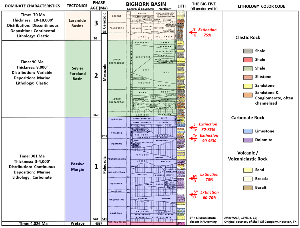
Geologic Stratigraphic Column...

A geologic stratigraphic column is basic reference material for a geologist.  Below is one for the Bighorn Basin with formation names, ages, rock type, major extinctions and the tectonic setting.  Note that thickness on this stratigraphic chart has no resemblance to rock thickness.  The relatively young Cenozoic sediments are the thickest formations and filled the central part of the basin. 
Geologic stratigraphic column for Bighorn Basin, Wyoming
Proudly powered by Weebly
  • Home
    • Wow Factor
    • Geological Factor
    • Stratigraphic Column
    • Wyoming Links
    • About The Geologists
    • Contact Us
  • Map of GeoWyo Top Spots
  • Albany-Laramie Counties
    • Big Hollow
    • Como Bluff
    • Snowy Range Stromatolites
    • Sybille Canyon - WY Highway 34
    • Vedauwoo
    • Wyoming Diamonds
  • Big Horn County
    • Ancient River Channel & Sheep Mountain
    • Bighorn Canyon
    • Bighorn Mountain Byways Part I
    • Bighorn River Area Caves
    • Devil's Kitchen
    • Medicine Lodge Tensleep Sandstone
    • Red Gulch Alkali Backcountry Byway
    • Red Gulch Dinosaur Tracksite & Sundance Seaway
    • Shell Dinosaur Bone Beds
  • Campbell County
    • Pumpkin Buttes
  • Carbon County
    • Battle Pass Byway - WY Highway 70
    • Encampment & Sierra Madre Mtns
    • Freezeout Hills
    • Rawlins Uplift
    • Shirley Basin
  • Converse County
    • Ayres Natural Bridge
    • Douglas Crater Field
  • Crook County
    • Devils Tower & Black Hills
  • Fremont County
    • Gas Hills & Crooks Gap Uranium
    • Red Canyon
    • Sinks Canyon
    • South Pass
  • Goshen-Platte Counties
    • Fort Laramie & Hartville Uplift
    • Goshen Hole
  • Hot Springs County
    • Anchor Dam
    • Dinosaur Marbles
    • Thermopolis Hot Springs
    • Wind River Canyon Part 1
    • Wind River Canyon Part 2
  • Johnson County
    • Hole In The Wall & Red Wall Country
  • Laramie County
    • Cheyenne Tablelands and Gangplank
  • Lincoln County
    • Fossil Butte
    • Periodic Spring
  • Natrona County
    • Bessemer Bend
    • Casper Mountain
    • Ervay Basin
    • Granite Mountains
    • Hells Half Acre
    • Rattlesnake Hills
  • Niobrara County
    • Lusk Area
  • Park County
    • Absaroka Volcanic Province
    • Beartooth Highway
    • Buffalo Bill Dam & Rattlesnake Mtn.
    • Clarks Fork Canyon
    • Cody Hydrothermal System
    • Dead Indian Hill
    • The Great Unconformity
    • Heart Mountain
    • Kirwin
    • Oregon Basin Oil Field
    • McCullough Peaks
    • Polecat Bench & PETM
    • Sunlight Basin
    • Tatman Mountain & Squaw Peaks
  • Sheridan County
    • Bighorn Mountain Byways Part II
  • Southeast Wyoming
    • North Platte River: One Dammed Thing After Another
  • Southern Powder River Basin
    • K-T Boundary
  • Sublette County
    • Titcomb Basin
  • Sweetwater County
    • Adobe Town
    • Flaming Gorge
    • Lake Gosiute & the Blue Forest
    • Leucite Hills
  • Teton County
    • Gros Ventre Range & Granite Hot Springs
    • Northern Tetons Geologic Wonders
    • Two Ocean Pass
  • Uinta-Lincoln Counties
    • Wyoming Thrust Belt
  • Washakie County
    • Big Cedar Ridge
    • Castle Gardens
    • Tensleep Canyon & Sweet 16
    • Upper Nowood River Valley
  • MONTANA
    • Crazy Mountains and Basin
    • Grasshopper Glacier
    • Nye-Bowler Fault Zone
    • Pryor Mountains
    • Red Lodge - Bear Creek Coal