Wow Factor (3 out of 5 stars):

Geologist Factor (3 out of 5 stars):

Attraction
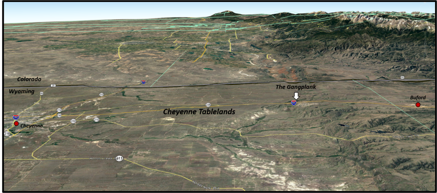
The Cheyenne Tablelands are a remnant of a thick sedimentary wedge deposited during the Oligocene and Miocene, that buried the Laramie Range and thinned eastward onto the Great Plains of western Nebraska. The Gangplank, a narrow strip of this surface persists today and provided the 19th- 20th centuries transcontinental railroads and highways a gentle route over the mountains. Prior travel was by wagon, animal, or foot. What the discovery of South Pass did for western expansion, “The Gangplank” did for engine driven travel and development of the future Wyoming.
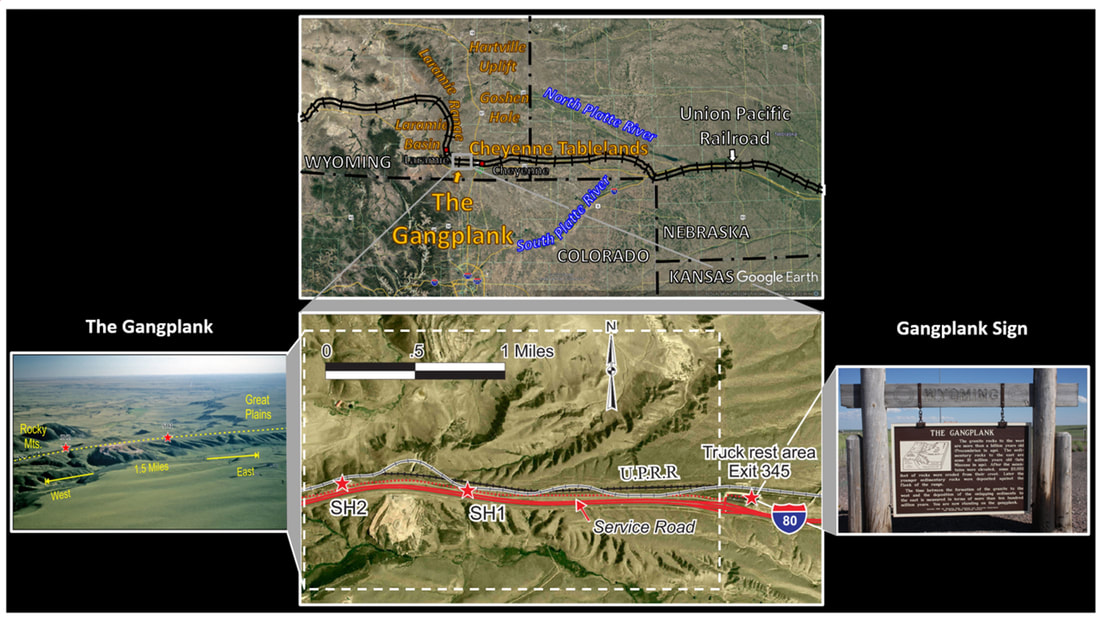
Top: Areial view of the Cheyenne Tablelands area, southeast Wyoming, and western Nebraska. Bottom center: Close up aerial photo map of the Gangplank and vicinity. Stop SH1 – Remnant man-made fill and cut. Until 2005, the Gangplank sign, now at the truck stop, was located here at an I-80 pull over. This location gives the visitor a fine view of the valleys to the north and south which define the edges of the Gangplank. To the north of the railroad are a fill and cut which were part of the original U.P. route on the Gangplank. The modern right of way (black line) dates from the early 1900s and avoids slight bends in the original alignment (white line), permitting higher train speeds. However, the modern line only reduces the twenty miles distance between Cheyenne and Buford by 600 feet. Stop SH2 – Gangplank view and quarry for railroad trackbed ballast. This is the tip of the arrowhead-shaped Gangplank and provides another fine view. Here you can put one foot on the stratified rocks of the Great Plains and the other on the granite of the Rocky Mountains. The large quarry to the west is operated by Martin Marietta Materials and provides granite ballast for the Union Pacific and Burlington Northern Santa Fe railroads. Left: Areial view of SH1 & SH2 (red stars). Right: Historical marker at east end of rest stop.
Image: Top: Google Earth; Bottom & Left: https://www.visitlaramie.org/things-to-do/self-guided-tours/railroads-of-albany-county/; Right: https://s3.amazonaws.com/gs-waymarking-images/9dff757f-420e-4852-9187-509a74972dc3.jpg.
Image: Top: Google Earth; Bottom & Left: https://www.visitlaramie.org/things-to-do/self-guided-tours/railroads-of-albany-county/; Right: https://s3.amazonaws.com/gs-waymarking-images/9dff757f-420e-4852-9187-509a74972dc3.jpg.
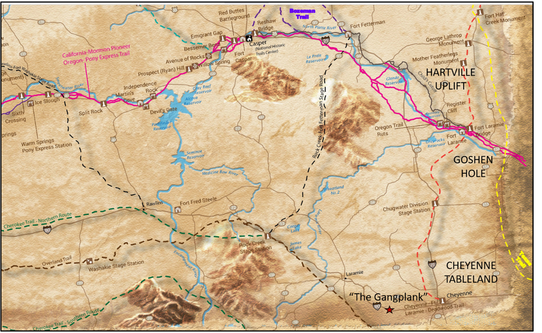
Historic trails of southeast Wyoming. Freight and stage trails remained in use until 1887. Cattle drives continued on the Texas trail (yellow dash) through 1897.
Image: After BLM, https://www.blm.gov/documents/wyoming/public-room/map/wyoming-historic-trails-map.
Image: After BLM, https://www.blm.gov/documents/wyoming/public-room/map/wyoming-historic-trails-map.
Gangplank History
The Gangplank was discovered by accident in the Laramie Mountains (then called the Black Hills) in September 1865, when Gen. Grenville Dodge and troopers were escaping a hostile Indian party. They had scrambled down a ridge south of Crow Creek escaping to the plains below. General Dodge told his guide "If we can save our scalps, I believe we've found a pass through which the Union Pacific can go."(https://www.pbs.org/wgbh/americanexperience/features/tcrr-dodge/). This was the route chosen for the transcontinental railroad two years later. The gangplank was used for the transcontinental Lincoln Highway (conceived 1912, dedicated 1913) and four decades later for Interstate 80 (designated 1956, completed 1986).
A transcontinental railroad route connecting eastern rail system with the west coast was first proposed to Congress in 1847. Congress authorized the Secretary of War to survey possible routes for a transcontinental railroad in 1853. Five major Pacific Railroad routes were explored by the U.S. Army Corps of Topographical Engineers from 1853 to 1855. They produced a 12 volumes record of the geography, geology, and botany of the western half of the continent. (Reports of Explorations and Surveys, to ascertain the most practicable and economical route for a railroad from the Mississippi River to the Pacific Ocean, made under the direction of the Secretary of War, in 1853-4, Volumes I-XII; http://www.cprr.org/Museum/Pacific_RR_Surveys/).
No route was selected at the time but Jefferson Davis, Secretary of War and future President of the Confederacy, summarized his conclusions of the routes in volume I:
- “47th Parallel-‐St. Paul MN to Seattle WA-‐2,025 miles-‐estimated cost of $141MM.
- 41st Parallel-‐Council Bluff IA to Benicia CA-‐2,031 miles-‐route rejected because of insufficient data, but it was the first one built.
- 38th Parallel-‐St. Joseph MO to Sacramento CA-‐ ‘the route is considered impracticable’.
- 35th Parallel-‐Fort Smith AR to San Pedro CA-‐1,892 miles-‐estimated cost of $169MM (favored by Davis).
- 32ndParallel-‐Fulton AR to San Diego CA-‐1,618 miles-‐estimated cost of $69MM.”
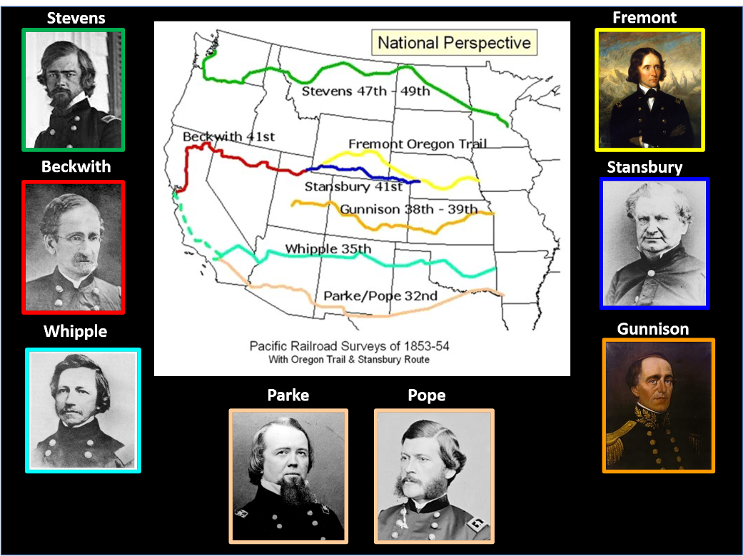
The western railroad surveys completed in the 1850’s by the U. S. Army Corps of Topographical Engineers.
Image Map: After Nelson, M., 2013, RMFMS: The Gangplank—Wyoming II: Rocky Mountain Federation of Mineralogical Societies Newsletter, Vol. 44, Issue 10, Fig. 2, p. 2; http://rmfms.org/uploads//newsletters/2013/2013-10-Nov-RMFMS-Newsletter.pdf. Stevens, Beckwith, Whipple, Parke, Pope, Gunnison: https://sites.google.com/a/umn.edu/the-pacific-railroad-surveys-1853---1854/home; Stansbury: https://www.geographicus.com/P/ctgy&Category_Code=stansbury; Fremont: https://en.wikipedia.org/wiki/John_C._Fr%C3%A9mont#/media/File:John_C._Fr%C3%A9mont.jpg.
Image Map: After Nelson, M., 2013, RMFMS: The Gangplank—Wyoming II: Rocky Mountain Federation of Mineralogical Societies Newsletter, Vol. 44, Issue 10, Fig. 2, p. 2; http://rmfms.org/uploads//newsletters/2013/2013-10-Nov-RMFMS-Newsletter.pdf. Stevens, Beckwith, Whipple, Parke, Pope, Gunnison: https://sites.google.com/a/umn.edu/the-pacific-railroad-surveys-1853---1854/home; Stansbury: https://www.geographicus.com/P/ctgy&Category_Code=stansbury; Fremont: https://en.wikipedia.org/wiki/John_C._Fr%C3%A9mont#/media/File:John_C._Fr%C3%A9mont.jpg.
Abraham Lincoln had a chance meeting with Dodge in Council Bluffs in August 1859, where they discussed the best route for the transcontinental railroad. On July 1, 1862, President Lincoln signed the Pacific Railroad Act. The President summoned Dodge to Washington D.C. in 1863 to discuss the route and starting location for the railroad. Lincoln issued an executive order on November 17, 1863 (two days before the Gettysburg Address) setting Council Bluffs as the railroad's eastern terminus where Gen. Dodge had advised. Dodge resigned from the military in May 1866 to become chief engineer for the Union Pacific railroad.
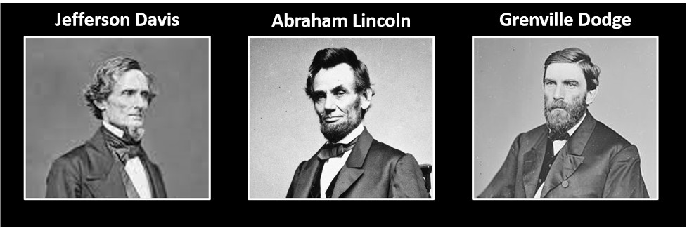
Left: Secretary of War Jefferson Davis, Center: President Abraham Lincoln, Right: Major General Grenville Dodge.
Image: Davis: https://en.wikipedia.org/wiki/Jefferson_Davis; Lincoln: https://www.timeforkids.com/g34/abraham-lincoln; Dodge: https://commons.wikimedia.org/wiki/File:Hon._Grenville_M._Dodge_-_NARA_-_527475.jpg.
Image: Davis: https://en.wikipedia.org/wiki/Jefferson_Davis; Lincoln: https://www.timeforkids.com/g34/abraham-lincoln; Dodge: https://commons.wikimedia.org/wiki/File:Hon._Grenville_M._Dodge_-_NARA_-_527475.jpg.

Modes of transportation in Wyoming. Top Left: Last Black Hills Stage leaving Cheyenne, 1887 . Top Right: Cheyenne train depot, 1876. Bottom Left: U.S. Army Corps Transcontinental Convoy on Lincoln Highway (near Fort D.A. Russell), 1918. Bottom Right: Interstate 80, 2020.
Image: Stage: https://wyostatearchives.wordpress.com/2014/03/25/on-this-day-in-wyoming-history-death-of-johnny-slaughter/.Train: https://www.wyomingnews.com/historic-photos-of-the-union-pacific-depot-in-cheyenne/collection_fb39d11e-55f1-11e7-9009-17e8f7bb4312.html. Convoy: http://www.wyomingtalesandtrails.com/lincoln1a.html. I-80: After screen capture: https://www.youtube.com/watch?v=uFEw9zMzpnA
Image: Stage: https://wyostatearchives.wordpress.com/2014/03/25/on-this-day-in-wyoming-history-death-of-johnny-slaughter/.Train: https://www.wyomingnews.com/historic-photos-of-the-union-pacific-depot-in-cheyenne/collection_fb39d11e-55f1-11e7-9009-17e8f7bb4312.html. Convoy: http://www.wyomingtalesandtrails.com/lincoln1a.html. I-80: After screen capture: https://www.youtube.com/watch?v=uFEw9zMzpnA
At the July 4, 1867 celebration, two important announcements on site selection were announced. Crow Creek townsite (future Cheyenne, Dakota Territory was platted the next day and incorporated on August 8, 1868) would be the Union Pacific’s Rocky Mountain headquarters and an Army post (Fort D.A. Russell, established September 8, 1867) would be constructed nearby to protect railroad and telegraph workers. The railroad tracks reached Cheyenne on November 13, 1867. The Territory of Wyoming was established on July 25, 1868. Camp Carlin depot (aka Cheyenne depot) was established in August 1867, 1.5 miles downstream along Crow Creek from the fort. A historic marker is all that remains of this once major Army supply depot.
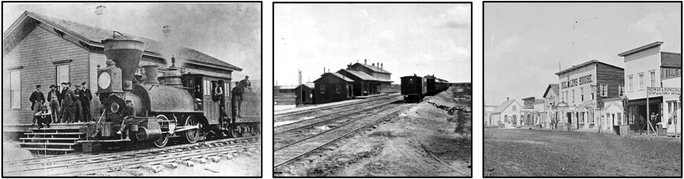
Left: The first Union Pacific locomotive to arrive in Cheyenne was this small work engine, 1867. The U.P. has played a big role in the city's politics, economy, and culture ever since. Middle: The Union Pacific depot and hotel, Cheyenne, 1869, where Gov. Campbell disembarked in the rain. USGS photo. Right: The Union Pacific boom created Cheyenne, shown here in 1869. William Henry Jackson photo.
Image: Left: https://www.wyohistory.org/encyclopedia/cheyenne-magic-city-plains. Middle: https://www.wyohistory.org/encyclopedia/john-campbell-and-invention-Wyoming; Right: https://www.wyohistory.org/encyclopedia/industry-politics-and-power-union-pacific-wyoming.
Image: Left: https://www.wyohistory.org/encyclopedia/cheyenne-magic-city-plains. Middle: https://www.wyohistory.org/encyclopedia/john-campbell-and-invention-Wyoming; Right: https://www.wyohistory.org/encyclopedia/industry-politics-and-power-union-pacific-wyoming.
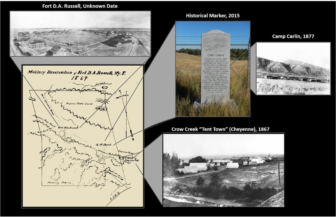
Fort Russell army presence for worker protection from Indian trouble and to manage the second largest Army depot in the United States.
Image: Base map & Ft. Russell: http://sites.rootsweb.com/~wytttp/forts/ftdarussell/history.htm; Historical marker: https://www.hmdb.org/Photos3/343/Photo343807o.jpg; Camp Carlin: Wyoming State Archives Historic Photo Collectionhttp://spcrphotocollection.wyo.gov/luna/servlet/detail/SPCRACV~3~3~2465753~146045:Forts-&-Camps---Camp-Carlin?sort=title_or_file%2Cidentifier%2Cimage_title%2Ccoverage_or_location&qvq=q:camp%20carlin;sort:title_or_file%2Cidentifier%2Cimage_title%2Ccoverage_or_location;lc:SPCRACV~3~3&mi=6&trs=26; Crow Creek “tent town”:
https://wyostatearchives.files.wordpress.com/2014/07/sub-neg-977-and-8777-cheyenne-tent-city-ca-1862.jpg.
Gangplank Geology
Cheyenne is located on the high plains of southeast Wyoming. The town, as well as the Wyoming territory, owe their existence to the Union Pacific Railroad. Gov. John Campbell’s address to the first Territorial Legislature noted “For the first time in history of our country the organization of a Territorial government was rendered necessary by the building of a railroad. Heretofore the railroad has been the follower instead of the pioneer of civilization.” (http://spcrphotocollection.wyo.gov/luna/servlet/media/book/showBook/wyo~1~1~11~149322).
The route of the first transcontinental railroad through southern Wyoming is due to the region’s geography and geology.
The route of the first transcontinental railroad through southern Wyoming is due to the region’s geography and geology.

Geologic map of Cheyenne Tablelands region and The Gangplank, Wyoming.
Image: Map: After https://www.wsgs.wyo.gov/docs/wsgs-web-denver-basin-geologic-map.pdf. Gangplank: https://www.wsgs.wyo.gov/products/wsgs-2018-ip-13.pdf.
Image: Map: After https://www.wsgs.wyo.gov/docs/wsgs-web-denver-basin-geologic-map.pdf. Gangplank: https://www.wsgs.wyo.gov/products/wsgs-2018-ip-13.pdf.
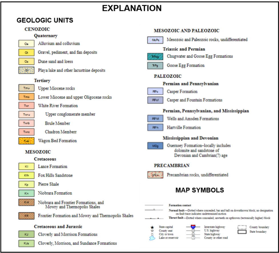
Explanation of geologic map units and symbols.
Image: Explanation: After https://www.wsgs.wyo.gov/docs/wsgs-web-denver-basin-geologic-map.pdf
Image: Explanation: After https://www.wsgs.wyo.gov/docs/wsgs-web-denver-basin-geologic-map.pdf
The Cheyenne Tablelands are the erosional remains of a Tertiary fluvial and volcanic sediments from basin fill in the northern Denver Basin. The sediments draped over crystalline basement rock of the Laramie Range and the folded Phanerozoic formations of the Denver Basin, extending onto the Great Plains of Nebraska. The Gangplank provided a topographic bridge that allowed the most favorable path over the Rocky Mountains. The Precambrian granitic rocks of the Sherman Summit are an area of low relief at about 8,000 feet elevation (ASL).
Tablelands are residual landforms typical for flat, layered rock sequences, formed due to dissection and cliff retreat. The cemented cap rocks are more resistant to erosion. All earth’s landscapes are ephemeral given the scale of geologic time.
Tablelands are residual landforms typical for flat, layered rock sequences, formed due to dissection and cliff retreat. The cemented cap rocks are more resistant to erosion. All earth’s landscapes are ephemeral given the scale of geologic time.
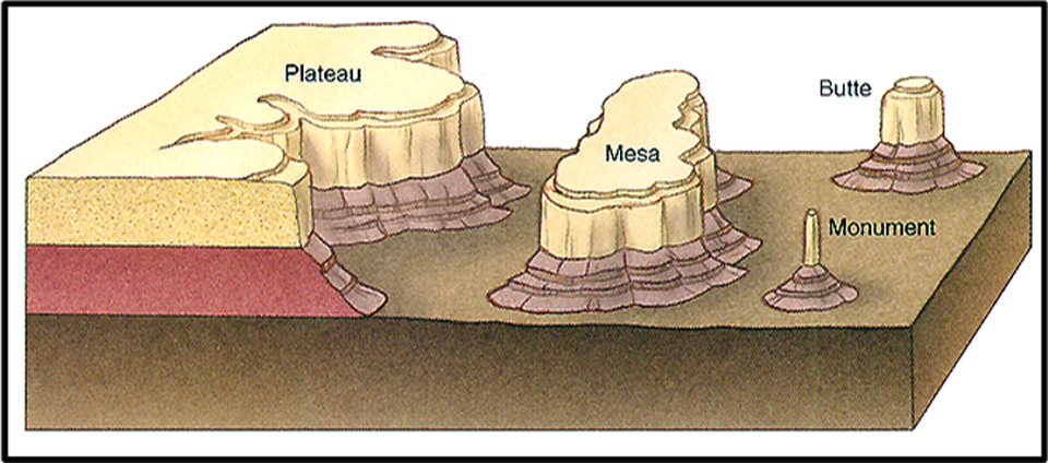
Typical erosional landforms developed in arid or semiarid areas as the High Plains region, southeast Wyoming.
Image: https://www3.nd.edu/~cneal/planetearth/lab-deserts/Erosional.html.
Image: https://www3.nd.edu/~cneal/planetearth/lab-deserts/Erosional.html.
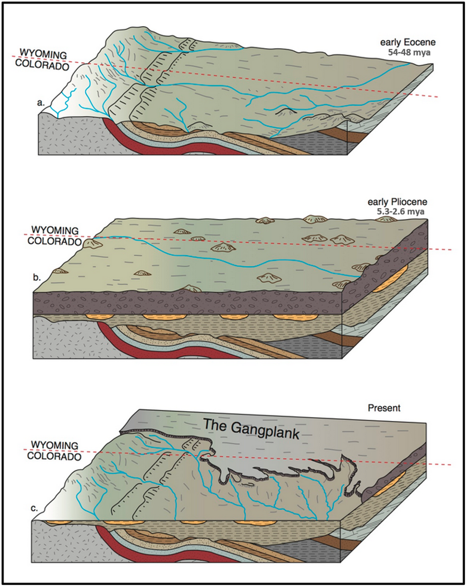
Block diagrams of development of the Gangplank. The post Laramide tectonics of early Eocene (top) was followed by erosion and burial of the mountains & deformed sedimentary strata in their own debris in early Pliocene through Oligocene (middle). The exhumation of the Rockies that began in the late Miocene continues today (bottom).
Image: After Cook, T. 2013; http://www.down2earthscience.com/wp-content/uploads/2013/03/Gangplank.jpg.
Image: After Cook, T. 2013; http://www.down2earthscience.com/wp-content/uploads/2013/03/Gangplank.jpg.
The surface rocks of the tablelands consist of nearly flat lying Cenozoic strata. The sediments are the debris of the Laramie Range transported by eastward flowing streams and volcanic ash from the Yampa and Elkhead Mountains volcanic fields of northwest Colorado. Stream terraces record the surface level at different stages of late Miocene (11.6-5.3) to Present exhumation.

Cenozoic rock units of the Cheyenne tablelands
Image; After Libra, R.D., Collentine, M., and Feathers, K.R., 1981, Occurrence and Characteristics of Ground Water in the Denver-Julesburg Basin, Wyoming, Fig. II-5, p. 23; http://library.wrds.uwyo.edu/occurrences/Volume_VII-A_-_Denver-Julesburg_Basin.pdf; and VerPloeg, A.J., 1995, Geologic map of the Cheyenne 30’ x 60’ quadrangle, southeastern Wyoming, western Nebraska, and northern Colorado: Wyoming State Geological Survey; https://www.wsgs.wyo.gov/products/wsgs-1995-ms-46.pdf.
Image; After Libra, R.D., Collentine, M., and Feathers, K.R., 1981, Occurrence and Characteristics of Ground Water in the Denver-Julesburg Basin, Wyoming, Fig. II-5, p. 23; http://library.wrds.uwyo.edu/occurrences/Volume_VII-A_-_Denver-Julesburg_Basin.pdf; and VerPloeg, A.J., 1995, Geologic map of the Cheyenne 30’ x 60’ quadrangle, southeastern Wyoming, western Nebraska, and northern Colorado: Wyoming State Geological Survey; https://www.wsgs.wyo.gov/products/wsgs-1995-ms-46.pdf.
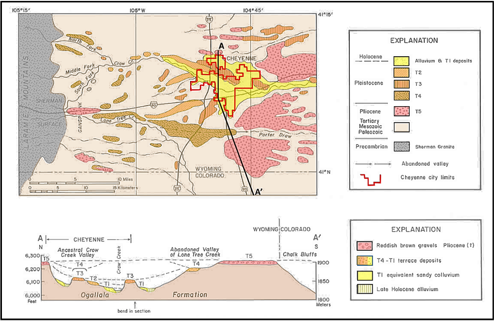
Map of late Cenozoic deposits and principal streams in the Gangplank and Cheyenne areas. Cross section AA’ profile showing late Cenozoic benches, terraces, the present flood plain, and associated deposits from Cheyenne to the Chalk Bluffs.
Image: After Cooley, M.E., 1991, The Cheyenne Tablelands, p. 453; in Wayne, W. J., Aber, J. S., Agard, S. S., Bergantino, R. N., Bluemle, J. P., Coates, D. A., Cooley, M. E., Madole, R. F., Martin, J. E., Mears, B., Jr., Morrison, R. B., Sutherland, W. M., 1991, Quaternary geology of the Northern Great Plains, in Morrison, R. B., ed., Quaternary nonglacial geology; Conterminous U.S.: Boulder, Colorado, Geological Society of America, The Geology of North America, v. K-2, Fig. 10, p. 453; https://core.ac.uk/download/pdf/220154552.pdf.
Image: After Cooley, M.E., 1991, The Cheyenne Tablelands, p. 453; in Wayne, W. J., Aber, J. S., Agard, S. S., Bergantino, R. N., Bluemle, J. P., Coates, D. A., Cooley, M. E., Madole, R. F., Martin, J. E., Mears, B., Jr., Morrison, R. B., Sutherland, W. M., 1991, Quaternary geology of the Northern Great Plains, in Morrison, R. B., ed., Quaternary nonglacial geology; Conterminous U.S.: Boulder, Colorado, Geological Society of America, The Geology of North America, v. K-2, Fig. 10, p. 453; https://core.ac.uk/download/pdf/220154552.pdf.
The Denver Basin of Wyoming has 31 named oil and gas fields, 18 of which are not currently producing oil or gas. Production in the basin has fluctuated through the years, but steadily increased by more than an order of magnitude from 2009 through 2019 (WOGCC, 2021). Reservoirs include the Upper Cretaceous Niobrara Formation (Kn) and Codell Sandstone (Kclcd) Member, Carlile Formations (Kcl); Lower Cretaceous Muddy Sandstone (Kmd), “J” (Kj) and Lakota (Kla) Sandstones, and Dakota Formation (Kd).
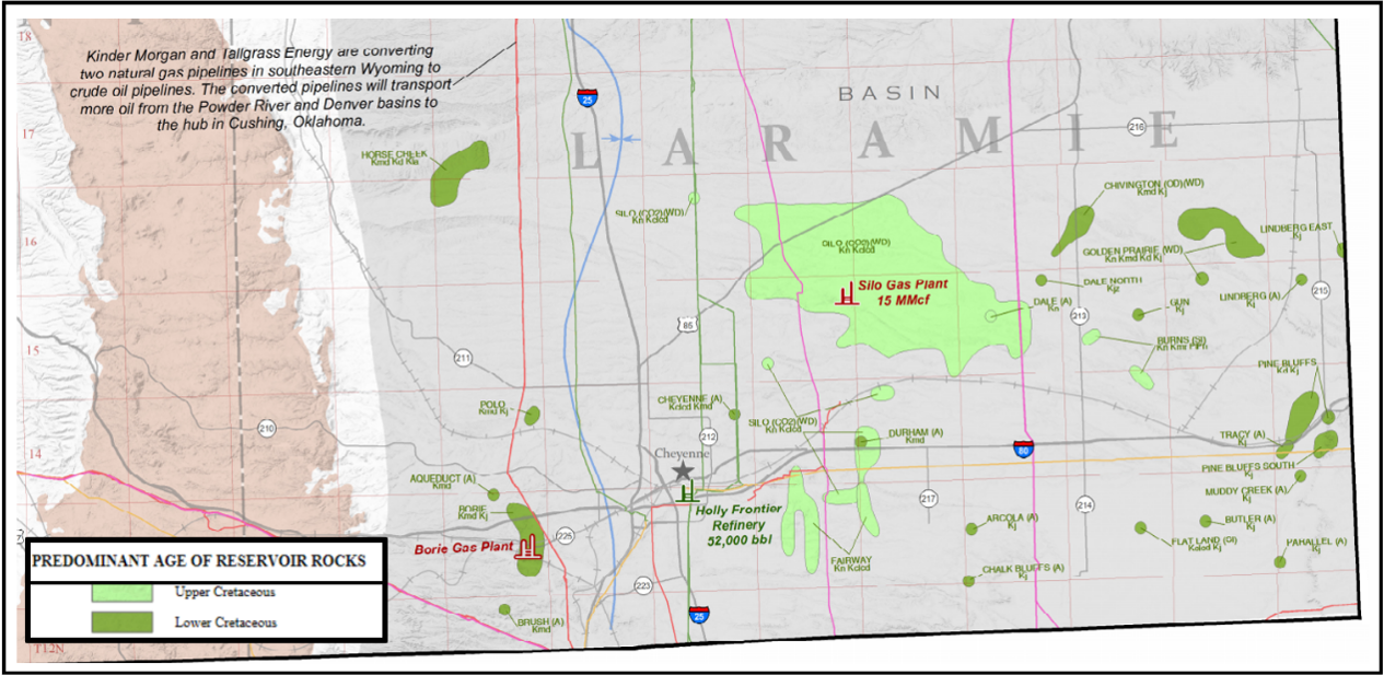
Oil and gas fields, Cheyenne Tablelands region of Wyoming.
Image: Toner, R.N., Lynds, R.M., and Stafford, J.E., 2019, Oil and gas map of Wyoming: Wyoming State Geological Survey Map Series 104, scale 1:500,000; http://sales.wsgs.wyo.gov/oil-and-gas-map-of-wyoming-2019/.
Image: Toner, R.N., Lynds, R.M., and Stafford, J.E., 2019, Oil and gas map of Wyoming: Wyoming State Geological Survey Map Series 104, scale 1:500,000; http://sales.wsgs.wyo.gov/oil-and-gas-map-of-wyoming-2019/.
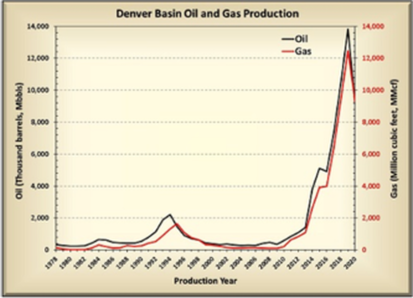
Oil and gas annual production, Cheyenne Tablelands region of Wyoming.
Image: Wyoming State Geological Survey, https://www.wsgs.wyo.gov/energy/oil-gas-basins.aspx.
Image: Wyoming State Geological Survey, https://www.wsgs.wyo.gov/energy/oil-gas-basins.aspx.
South aerial view, Cheyenne Tablelands.
Image: Google Earth.
Image: Google Earth.
Things-To-Do
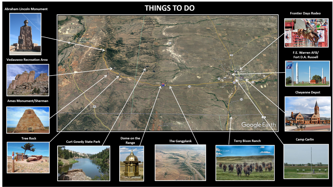
Places to visit in Cheyenne Tablelands area. North areial view of landscape.
Image: Lincoln: https://upload.wikimedia.org/wikipedia/commons/c/cd/Lincoln_Highway_Monument.jpg; Vedauwoo: https://www.wsgs.wyo.gov/public-info/tour-vedauwoo; Ames: https://www.wyohistory.org/encyclopedia/ames-monument; Tree Rock: Butko, B. 2013, Greetings from the Lincoln Highway: A Road Trip Celebration of America’s First Coast-to-Coast Highway, p. 188; Gowdy:https://www.cheyenne.org/listing/curt-gowdy-state-park/1538/; Dome: https://www.pinterest.com/pin/465207836505115129/; Gangplank: https://csmsgeologypost.blogspot.com/2013/08/the-gangplank-transcontinental-railroad.html; Bison: https://terrybisonranch.com/; Depot: https://www.radiomuseum.org/museum/usa/wyoming-transportation-museum-cheyenne/.html; Camp Carlin: http://www.fortwiki.com/Camp_Carlin; Warren AFB: https://www.wyomingnewsnow.tv/2020/08/14/air-force-announces-gbsd-locations-at-three-existing-missile-bases-including-fe-warren/; Rodeo: https://www.cfdrodeo.com/the-rodeo/.
Image: Lincoln: https://upload.wikimedia.org/wikipedia/commons/c/cd/Lincoln_Highway_Monument.jpg; Vedauwoo: https://www.wsgs.wyo.gov/public-info/tour-vedauwoo; Ames: https://www.wyohistory.org/encyclopedia/ames-monument; Tree Rock: Butko, B. 2013, Greetings from the Lincoln Highway: A Road Trip Celebration of America’s First Coast-to-Coast Highway, p. 188; Gowdy:https://www.cheyenne.org/listing/curt-gowdy-state-park/1538/; Dome: https://www.pinterest.com/pin/465207836505115129/; Gangplank: https://csmsgeologypost.blogspot.com/2013/08/the-gangplank-transcontinental-railroad.html; Bison: https://terrybisonranch.com/; Depot: https://www.radiomuseum.org/museum/usa/wyoming-transportation-museum-cheyenne/.html; Camp Carlin: http://www.fortwiki.com/Camp_Carlin; Warren AFB: https://www.wyomingnewsnow.tv/2020/08/14/air-force-announces-gbsd-locations-at-three-existing-missile-bases-including-fe-warren/; Rodeo: https://www.cfdrodeo.com/the-rodeo/.
- Lincoln Monument/Lincoln Highway (U.S. 30)
- Vedauwoo Recreation Area
- Ames Monument and Sherman Summit
- Tree Rock
- Curt Gowdy State Park
- Dome on the Range
- The Gangplank
- Terry Bison Ranch
- Camp Carlin
- Cheyenne Depot
- F.E. Warren AFB
- Frontier Days
Excellent self-guided tours of the transcontinental railroad are here:
- https://www.visitlaramie.org/things-to-do/self-guided-tours/railroads-of-albany-county/
- https://www.cheyenne.org/blog/post/trip-extension-inspiration-trainiac-tour/
Union Pacific and National Park Service maps of Sherman Hill:
- https://www.up.com/timeline/index.cfm/sherman-summit
- http://www.npshistory.com/publications/geology/bul/612/images/sheet9.jpg
Lincoln Highway tour:

The material on this page is copyrighted