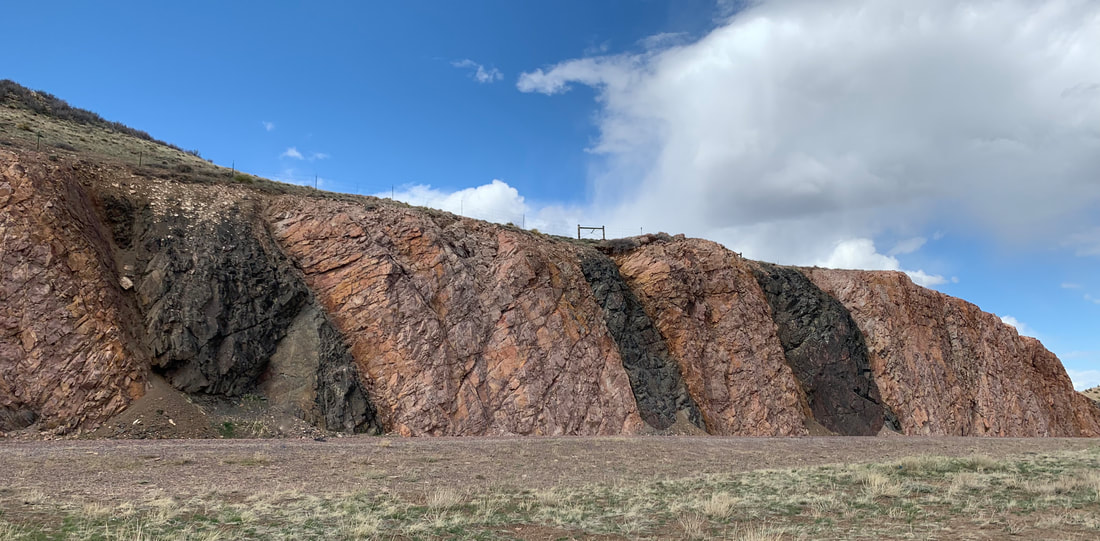
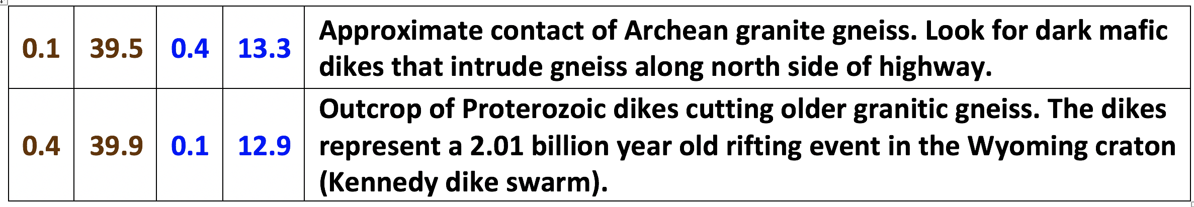
Archean granitic gneiss (2.7 billion years old) intruded by black Proterozoic mafic dikes (2.1 billion years old)
Photo by Mark Fisher
Photo by Mark Fisher
Wow Factor (2 out of 5 stars):

Geologist Factor (4 out of 5 stars):

Attraction
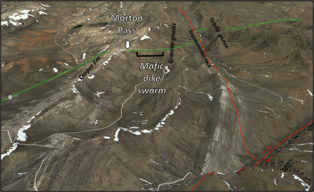
Drive across the Laramie range subparallel to the Cheyenne Belt tectonic suture. View the southernmost edge of the Archean Wyoming craton. At Morton Pass the granitic gneiss is intruded by a spectacular mafic dike swarm. The Laramie Anorthosite Complex is beautifully exposed along the drive.
The name Sybille evokes images of the legendary ancient Greek and Roman “prophetess” foretelling events from a revered location. However, the creek and canyon have no connection to the 8th Century BC oracle cult but were named by General John C. Fremont in 1842 after a trading post owner at the site of former Fort Platte (John Sybille, post located one mile northeast of Fort Laramie). Wyoming Highway 34 travels through Sybille Canyon in the central Laramie Range, southeast Wyoming. The range was created by the Laramide Orogeny, a mountain building event during the latest Cretaceous to early Eocene (70-55 million years ago). The Archean and Proterozoic rocks exposed in the core of the uplift record over a billion years of collision, accretion, metamorphism, deformation, and intrusion.
Highway 34 lies between and is aligned with two northeast-trending Precambrian tectonic structures, the Cheyenne Belt to the south and the Laramie Peak Shear Zone to the north. The Cheyenne Belt is the southern boundary between the Wyoming craton and the Proterozoic Colorado province. The Laramie Peak shear zone (LPSZ) marks the north margin of tectonic collision-driven regional metamorphism. South of the LPSZ lies the Palmer Canyon block, where apatite U-Pb ages are 1.78-1.76 billion years and the rocks have undergone Proterozoic high-grade regional metamorphism and deformation due to the Colorado orogen.
A second period of contact metamorphism occurred with the intrusion of the Laramie Anorthosite Complex, 1.44-1.43 billion years ago and the coeval Sherman Batholith.
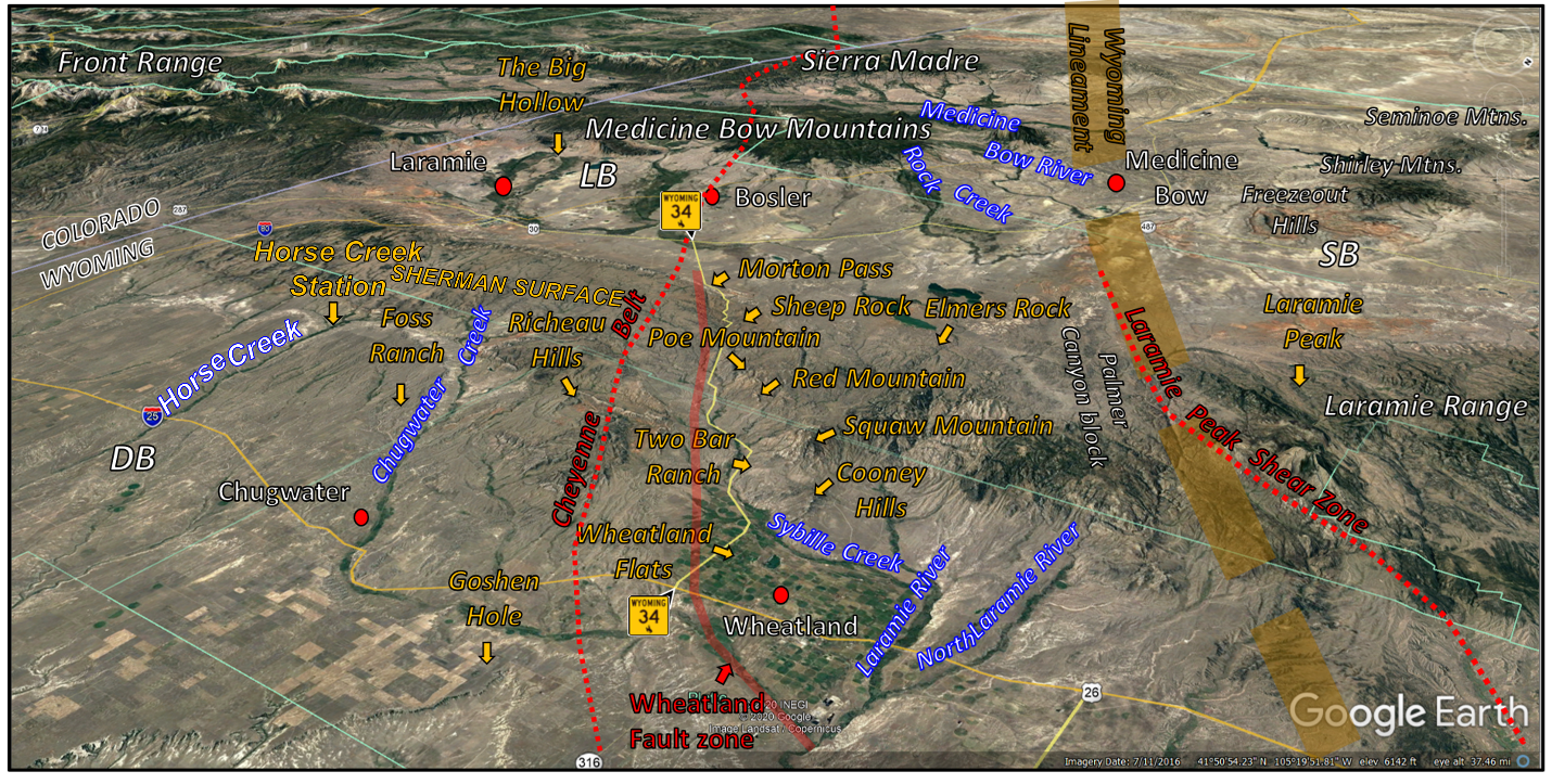
Southwest aerial view of the Sybille Canyon area (WY-34). Abbreviations: DB = Denver Basin; LB = Laramie Basin; SB = Shirley Basin.
Image: Google Earth.
Image: Google Earth.
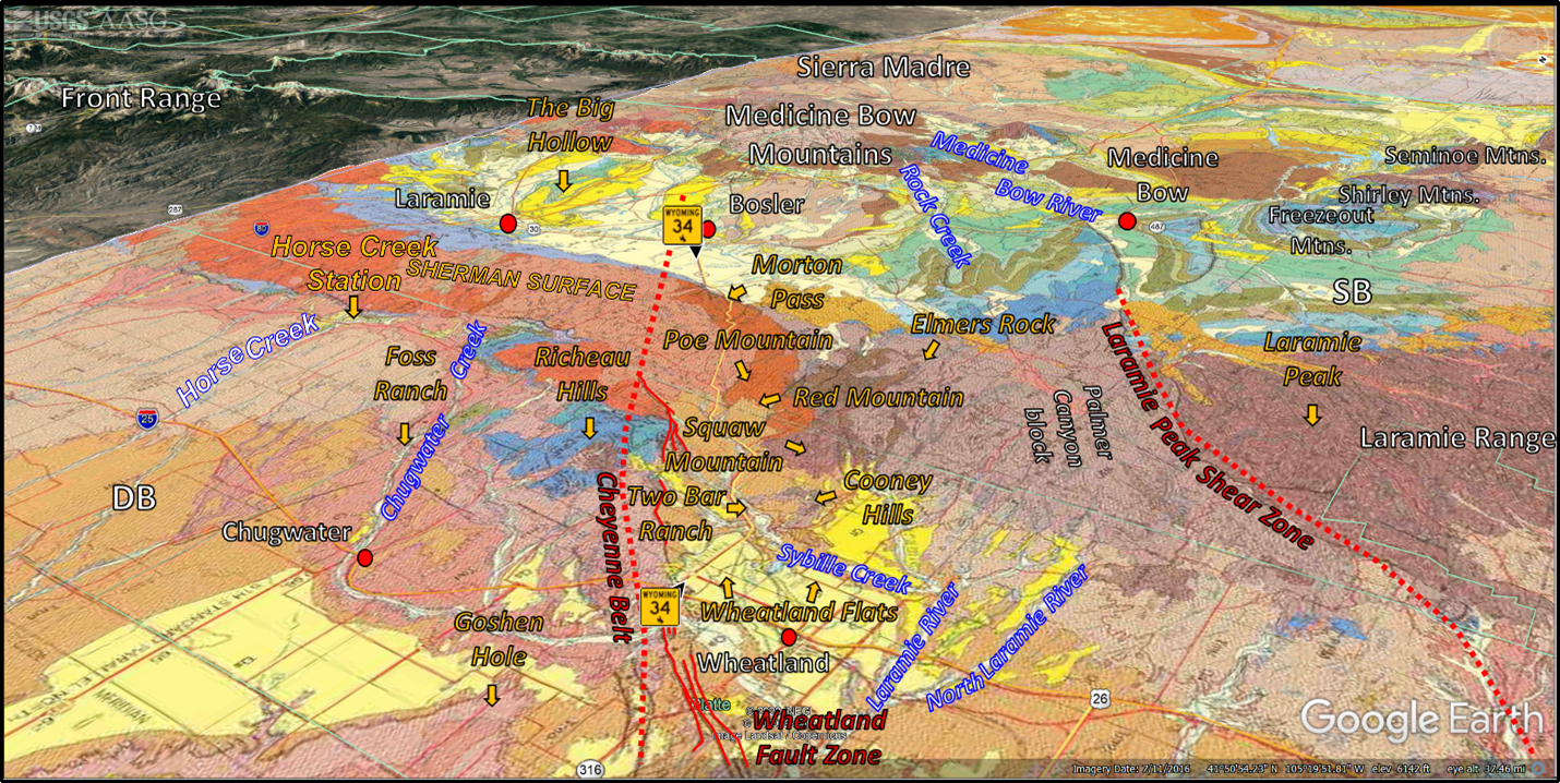
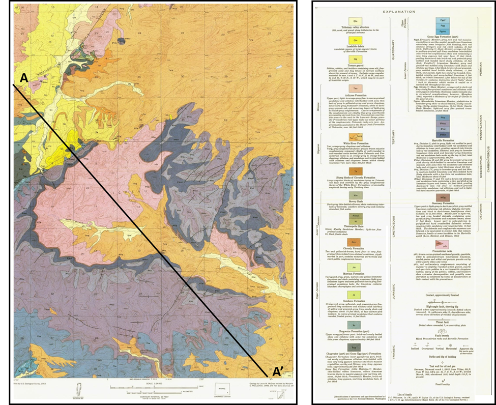
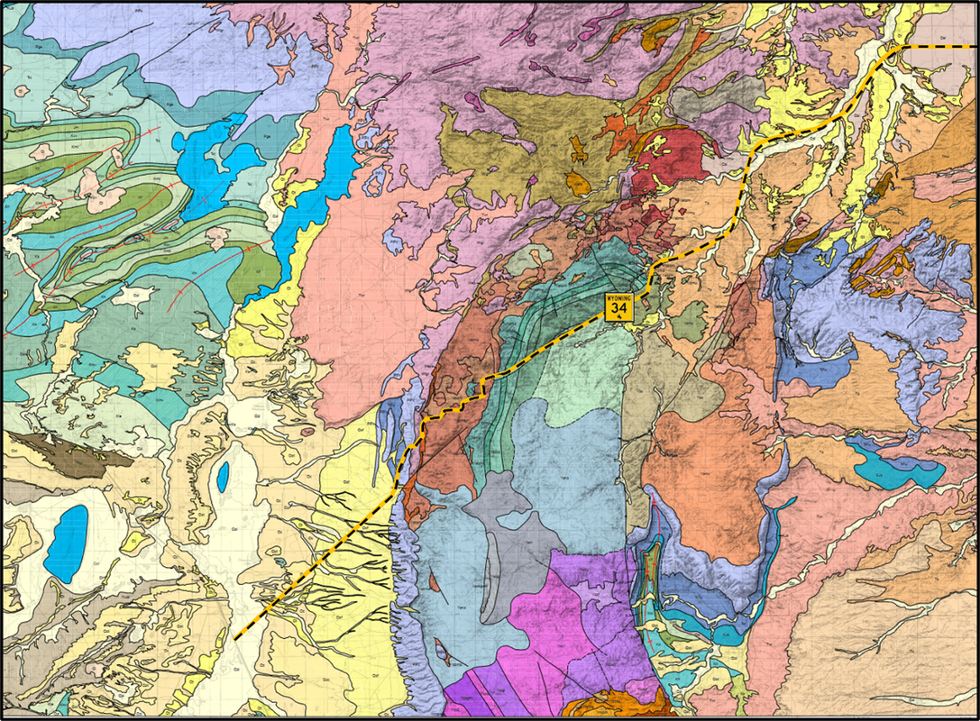
Sybille Canyon geologic map. View to the southwest.
Image: After Love, J.D., and Christiansen, A.C., 1985, Geologic Map of Wyoming: U.S. Geological Survey, 1: 500,000; https://ngmdb.usgs.gov/Prodesc/proddesc_16366.htm
Image: After Love, J.D., and Christiansen, A.C., 1985, Geologic Map of Wyoming: U.S. Geological Survey, 1: 500,000; https://ngmdb.usgs.gov/Prodesc/proddesc_16366.htm
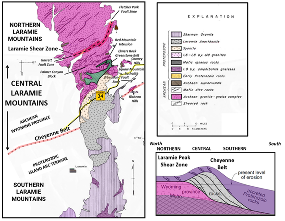
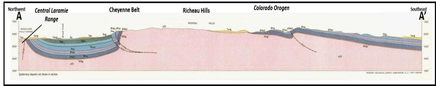
Tectonic & lithology map and generalized cross section of the Laramie Range showing the area of Archean high-grade gneiss and supracrustal rocks in the central Laramie Mountains bounded on the north by the Laramie Peak shear zone and on the south by the 1.43 billion years old Laramie Anorthosite Complex and Cheyenne suture. Regional metamorphism of the central Laramie Mountains is associated with collision of Proterozoic island arc terranes against the Archean Wyoming province along the Colorado orogeny.
Image: After Patel, S., Frost, C.D., and Frost, B.R., 1999, Contrasting responses of Rb–Sr systematics to regional and contact metamorphism, Laramie Mountains, Wyoming, USA: Journal of Metamorphic Geology, Volume 17, Number 3, Fig. 1, p. 260; https://www.geo.arizona.edu/~reiners/geos474-574/Pateletal1999JMG.pdf; After Resor, P.G., and Snoke, A.W., 2005, Laramie Peak shear system, central Laramie Mountains, Wyoming, USA: Regeneration of the Archean Wyoming province during Paleoproterozoic accretion: Geological Society, London, Special Publication 245, Fig. 10 C, p. 101; https://www.researchgate.net/publication/37724186_Laramie_Peak_shear_system_central_Laramie_Mountains_Wyoming_USA_Regeneration_of_the_Archean_Wyoming_province_during_Palaeoproterozoic_accretion.
Image: After Patel, S., Frost, C.D., and Frost, B.R., 1999, Contrasting responses of Rb–Sr systematics to regional and contact metamorphism, Laramie Mountains, Wyoming, USA: Journal of Metamorphic Geology, Volume 17, Number 3, Fig. 1, p. 260; https://www.geo.arizona.edu/~reiners/geos474-574/Pateletal1999JMG.pdf; After Resor, P.G., and Snoke, A.W., 2005, Laramie Peak shear system, central Laramie Mountains, Wyoming, USA: Regeneration of the Archean Wyoming province during Paleoproterozoic accretion: Geological Society, London, Special Publication 245, Fig. 10 C, p. 101; https://www.researchgate.net/publication/37724186_Laramie_Peak_shear_system_central_Laramie_Mountains_Wyoming_USA_Regeneration_of_the_Archean_Wyoming_province_during_Palaeoproterozoic_accretion.
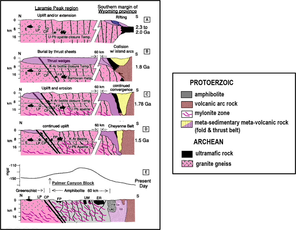
Tectonic model for development and deformation of the Laramie Peak shear zone, Palmer block, and the Cheyenne Belt suture. A. Progressive rifting of the craton between about 2.3 and 2.0 billion years ago, followed by dike intrusion with development of a passive margin. B. The marine basin closed by collision of island-arc terranes at about 1.8 billion years ago along the Cheyenne belt and the southern part of the Archean craton was tectonically buried under a fold-and-thrust belt. C. Continued uplift and subsequent erosion removed the island-arc rocks north of the Cheyenne belt. Metamorphism and deformation about 1.78 to 1.74 billion years ago. Horse Creek Complex intrudes during waning stages of Colorado orogeny. D. Continued uplift and erosion south of Laramie Peak shear and north of Cheyenne Belt about 1.5 billion years ago. E. Present day surface displays the 1.43 billion year old Laramie Anorthosite Complex and Sherman batholith intrusions. Gravity profile of reverse faulted (arrow) intracratonic uplift has a broad gravity high associated with the high-grade metamorphic block south of Laramie Peak shear zone, and local gravity highs over exposures of ultramafic bodies. Abbreviations: CP = Cottonwood Park, E = Esterbrook, ER = Elmers Rock, FP = Fletcher Park, LAC = Laramie Anorthosite Complex, LP = Laramie Peak, SB = Sherman Batholith, UM = Ultramafic bodies.
Image: After Chamberlain, K.R., Patel, S.C., Frost, B.R., and Snyder, S.Y., 1993, Thick-skinned deformation of the Archean Wyoming province during arc-continent collision: Geological Society of America Geology, Vol, 21, Fig. 5, p. 997; https://pubs.geoscienceworld.org/gsa/geology/article/21/11/995/205839/Thick-skinned-deformation-of-the-Archean-Wyoming.
Image: After Chamberlain, K.R., Patel, S.C., Frost, B.R., and Snyder, S.Y., 1993, Thick-skinned deformation of the Archean Wyoming province during arc-continent collision: Geological Society of America Geology, Vol, 21, Fig. 5, p. 997; https://pubs.geoscienceworld.org/gsa/geology/article/21/11/995/205839/Thick-skinned-deformation-of-the-Archean-Wyoming.
Rodeo Horse Named Steamboat
The tectonic forces unleashed here in southeast Wyoming were, in the opinion of many cowboys, recapitulated in a rodeo horse named Steamboat. “The horse that couldn’t be ridden,” was foaled on the Foss Ranch, near Chugwater in 1894, central Laramie Range country. The black colt ran feral over the range for several years and then sold to the Two Bar Ranch, Swan Land and Cattle Company, near Wheatland. The name Steamboat comes from accidental damage to his nasal passage that caused the bronc to whizz and blow like a steamboat and wildly buck whenever anyone tried to ride him. He could not be broken as a cow pony, so he was repeatedly sold until acquired by the Irwin Brothers rodeo. Steamboat was euthanized in 1914 due to an incurable blood infection. Steamboat’s spirit lives on in the bucking bronc and rider logo.
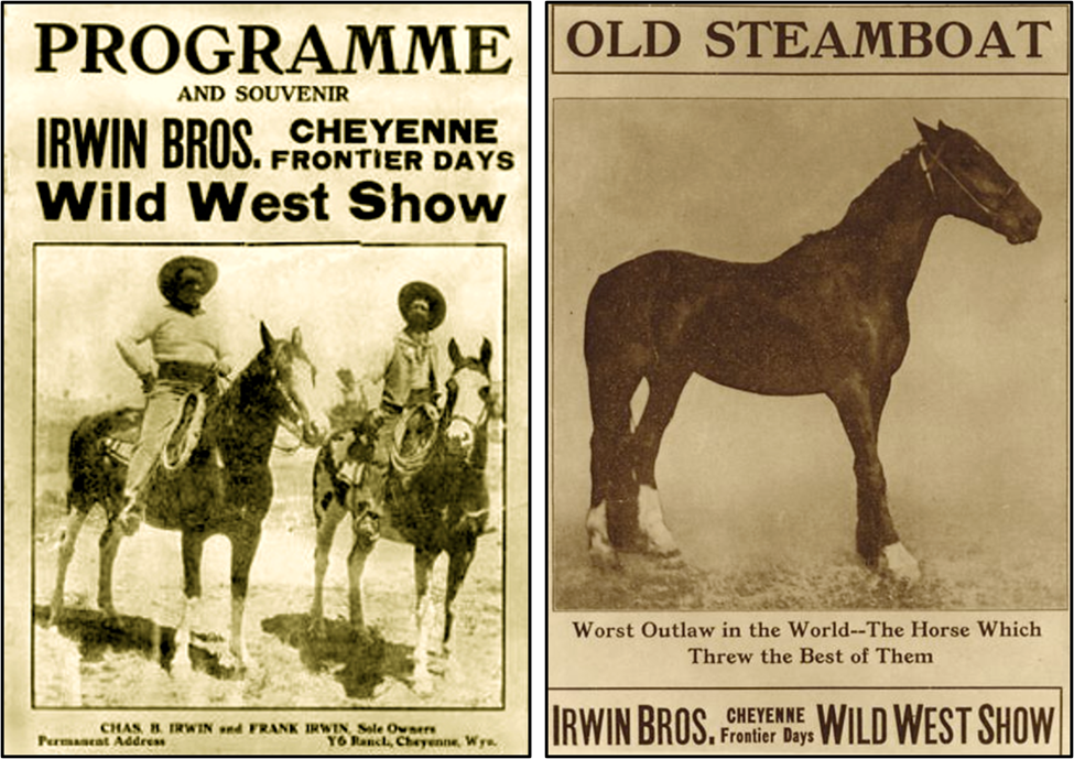
Left: Charles and Frank Irwin; Right: Steamboat image from Frontier Days program.
Image: Left: http://www.wyomingtalesandtrails.com/frontierdaysirwin.html;
Right: Moulton, C., 2005, Rodeo Flight School: True West; https://truewestmagazine.com/rodeo-flight-school/.
Image: Left: http://www.wyomingtalesandtrails.com/frontierdaysirwin.html;
Right: Moulton, C., 2005, Rodeo Flight School: True West; https://truewestmagazine.com/rodeo-flight-school/.
Wyoming National Guard troops in WWI used the bronc and rider logo on their uniforms after a sketch by George N. Ostrom. The logo was officially adopted by the U.S. Army for regimental identification in 1918. Professor B.C. Buffin’s 1903 photo of Steamboat was used as a silhouette for the University of Wyoming football team uniform in 1921. The logo has become a symbol for the university and used by the entire athletic department. Wyoming registered the bronc and rider image as a trademark for state license plates in 1936. The Wyoming quarter bearing the logo was issued in 2007 by the U.S. Mint.
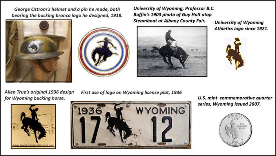
The bucking horse and rider logo (BH&R).
Image: Helmet and pin: https://www.wyohistory.org/education/toolkit/george-ostrom-and-his-bucking-bronc; Buffin photo:https://www.wyomingnews.com/news/steamboat-rides-on/article_be6eadc6-1a82-5789-b019-a732b9f69888.html; UW athletics:https://commons.wikimedia.org/wiki/File:Wyoming_Athletics_logo.svg; BH&R silhouette: Moulton, C., 2005, Rodeo Flight School: True West; https://truewestmagazine.com/rodeo-flight-school/; License: Satterly, 2018, https://commons.wikimedia.org/w/index.php?curid=73145510; Quarter: https://www.usmint.gov/coins/coin-medal-programs/50-state-quarters/wyoming.
Image: Helmet and pin: https://www.wyohistory.org/education/toolkit/george-ostrom-and-his-bucking-bronc; Buffin photo:https://www.wyomingnews.com/news/steamboat-rides-on/article_be6eadc6-1a82-5789-b019-a732b9f69888.html; UW athletics:https://commons.wikimedia.org/wiki/File:Wyoming_Athletics_logo.svg; BH&R silhouette: Moulton, C., 2005, Rodeo Flight School: True West; https://truewestmagazine.com/rodeo-flight-school/; License: Satterly, 2018, https://commons.wikimedia.org/w/index.php?curid=73145510; Quarter: https://www.usmint.gov/coins/coin-medal-programs/50-state-quarters/wyoming.
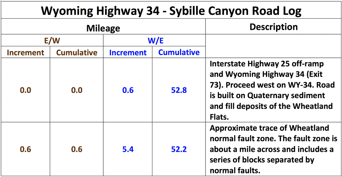
Sybille Canyon Geology Road Log along Wyoming Highway 34
This geologic road log follows Wyoming Highway 34, east to west through Sybille Canyon, Platte, and Albany Counties. It is adapted from:
- 1991 Wyoming Geological Association Guidebook (Frost, R.B. and Roberts, S., Editors)
- Frost, B.R., Frost, C.D., Chamberlain, K.R., Scoates, J.S., Lindsley, D.H., 1996, A Field Guide to the Proterozoic Anorthositic, Monzonitic, and Granitic Plutons, Laramie Range Southeastern Wyoming: Colorado Geologic Survey OF-96-04-06
- Frost, B.R., Frost, C.D., Chamberlain, K.R., Scoates, J.S., Ingram, J.S., 2013, The Laramie anorthosite complex and its contact metamorphic aureole, in Abbott, LD. and Hancock, G.S., Editors, 2013, Classic Concepts and New Directions: Exploring 125 Years of GSA Discoveries in the Rocky Mountain Region, Field Guide 33, P. 237-258.
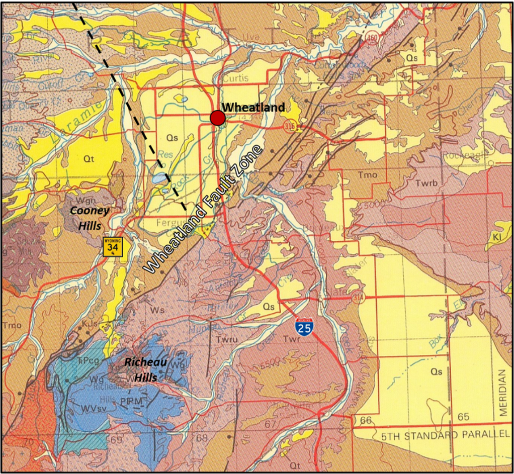
Geologic map of Wyoming showing the Wheatland Fault Zone. A major series of parallel early middle Miocene age normal faults cross 1-25 near the junction with Wyoming Highway 34. These faults are part of the Wheatland Fault Zone that extends southwest from south side of the Hartville Uplift to the north side of the high Richeau Hills. Oligocene and Miocene rocks (Tmo and Tmu) that cover the east flank of Laramie Mountains are preserved northwest of the Wheatland fault zone. The total amount of displacement across the fault zone is not precisely known, but it is in the range of 500 to 700 feet.
Image: After Love, J. D., and Christiansen, A. C., 1985, Geologic map of Wyoming: U.S. Geological Survey State Series Map, scale I:500,000; https://ngmdb.usgs.gov/Prodesc/proddesc_16366.htm
Image: After Love, J. D., and Christiansen, A. C., 1985, Geologic map of Wyoming: U.S. Geological Survey State Series Map, scale I:500,000; https://ngmdb.usgs.gov/Prodesc/proddesc_16366.htm
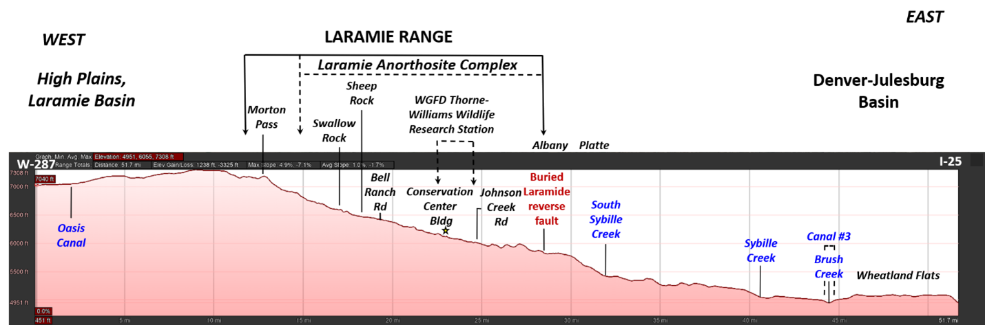
Wyoming Highway 34 elevation profile.
Image: Google Earth
Image: Google Earth
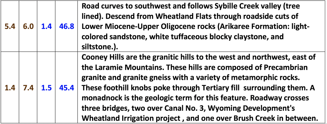
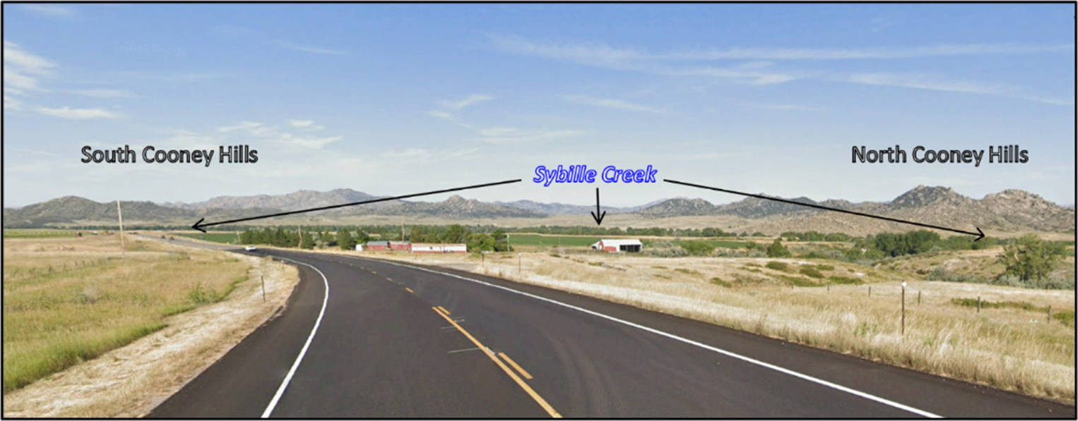
Southwestward bend in highway. Cooney Hills granite peaks east of Laramie Range. Sybille Creek valley is marked by trees in distance.
Image: Google Earth Street View.
Image: Google Earth Street View.
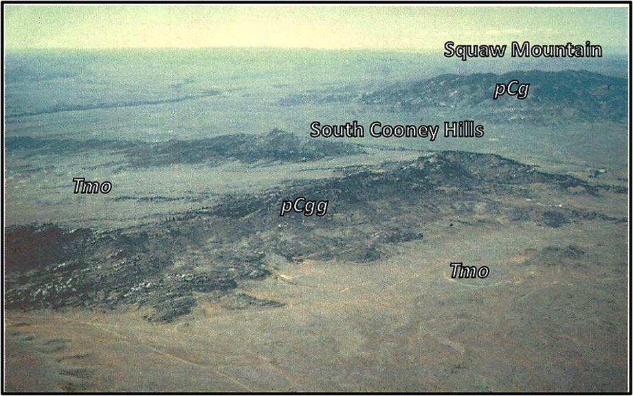
South-southwest aerial view of granite gneiss outlier of the Cooney Hills. Abbreviations: pCg = Precambrian granite, pCgg = Precambrian granite gneiss, Tmo = Tertiary Miocene and Oligocene rocks.
Image: Evanoff, E., 2015, Field Trip Guide Middle to Late Cenozoic Geology and Geomorphology of the Laramie Mountains, Wyoming: Colorado Scientific Society, Fig. 7, p. 13; 2015-Sept_Laramie_Mtns_WY_CSS_field_trip.pdf (coloscisoc.org).
Image: Evanoff, E., 2015, Field Trip Guide Middle to Late Cenozoic Geology and Geomorphology of the Laramie Mountains, Wyoming: Colorado Scientific Society, Fig. 7, p. 13; 2015-Sept_Laramie_Mtns_WY_CSS_field_trip.pdf (coloscisoc.org).
The Wyoming Development Corporation was established in 1883. Water taken from the Laramie River passed through tunnels, canals, and laterals to irrigate the Wheatland Flats. This was the nation’s first and largest private irrigation district.
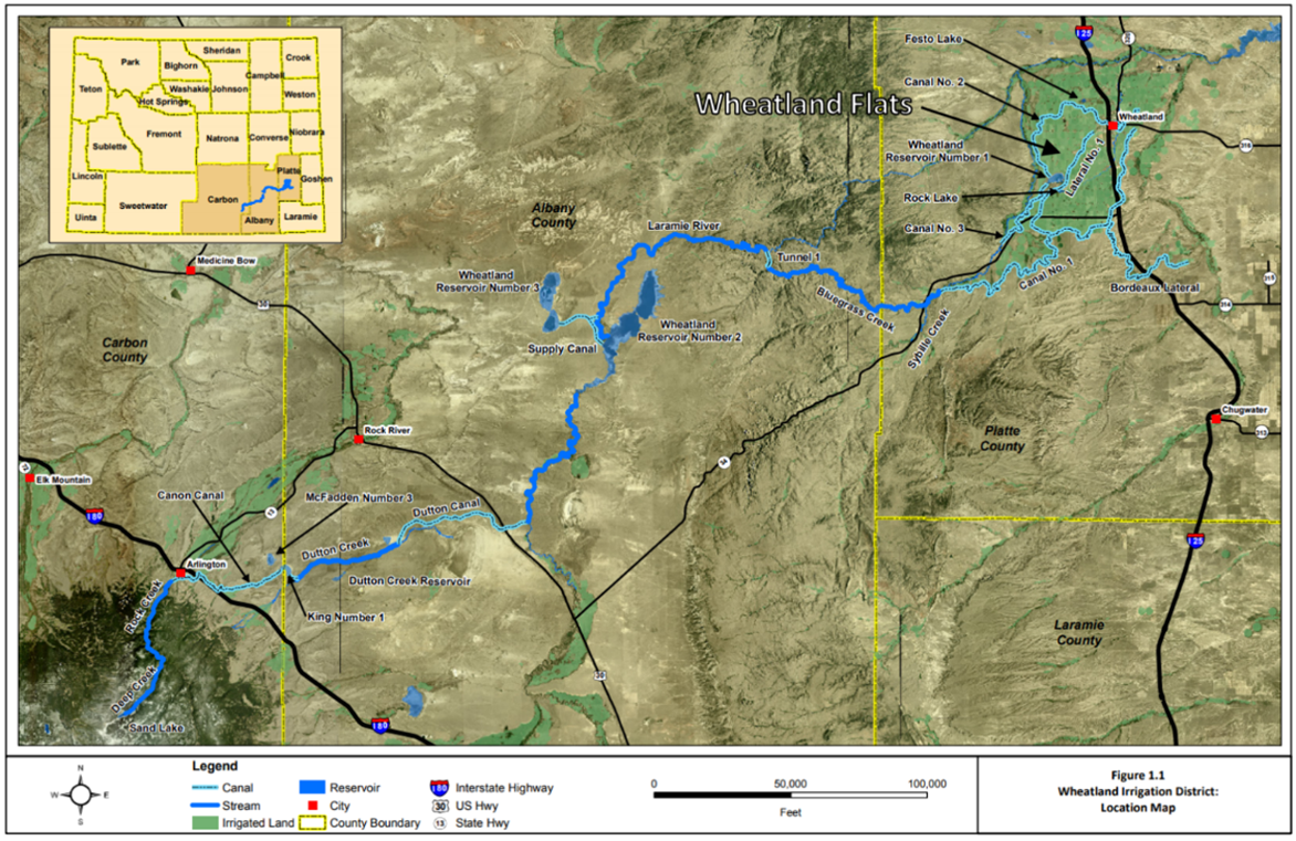
Wheatland Irrigation District. The Wheatland Flats portion was largely completed by 1886.
Image: Anderson Consulting Engineers, Inc., 2011, Final Report for the Wheatland Irrigation District Master Plan, Level I, Fig. 1.1, p. 1.3; http://library.wrds.uwyo.edu/wwdcrept/Wheatland/Wheatland_Irrigation_District-Master_Plan_Level_I-Final_Report-2011.pdf.
Image: Anderson Consulting Engineers, Inc., 2011, Final Report for the Wheatland Irrigation District Master Plan, Level I, Fig. 1.1, p. 1.3; http://library.wrds.uwyo.edu/wwdcrept/Wheatland/Wheatland_Irrigation_District-Master_Plan_Level_I-Final_Report-2011.pdf.
The original road (1926-1949) between Bosler and Wheatland was known as Wyoming 26. The former name was changed to avoid confusion with U.S. 26. A recent six-year project to replace sections of Wyoming 34 was completed in 1996.

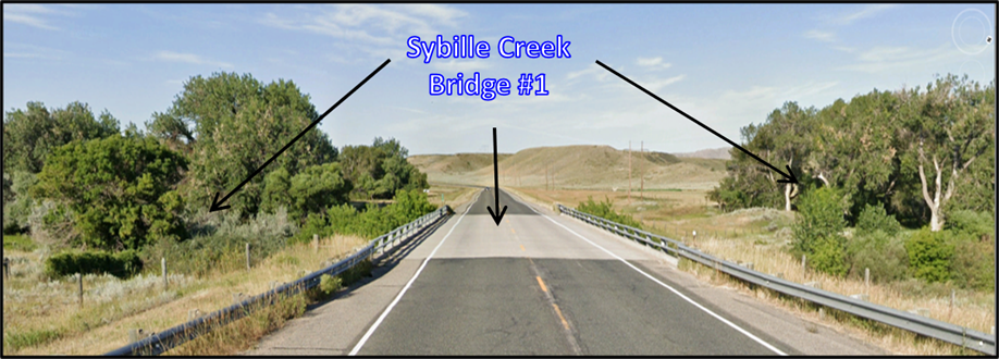
Sybille Creek (Bridge 1).
Image: Google Earth Street View.
Image: Google Earth Street View.

South distant view of Richeau Hills.
Image: Google Earth Street View.
Image: Google Earth Street View.
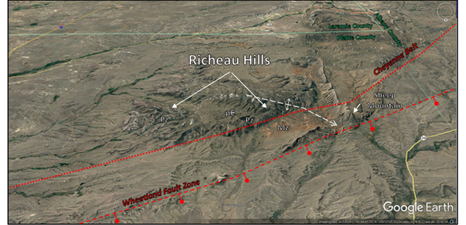
South aerial view of Laramide-Richeau Hills anticline. Abbreviations: Mz = Mesozoic rocks; Pz = Paleozoic rocks; pC = Precambrian Rocks. Red barbell symbol is on the downthrown side of Wheatland Fault Zone.
Image: Google Earth Street View.
Image: Google Earth Street View.
Richeau Hills geologic map and cross section AA’.
Image: After McGrew, L.W., 1967, Geologic map of the Richeau Hills quadrangle, Platte County, Wyoming: US. Geological Survey Geologic Quadrangle Map GQ-625, 1: 24,000; https://ngmdb.usgs.gov/Prodesc/proddesc_1935.htm.
Image: After McGrew, L.W., 1967, Geologic map of the Richeau Hills quadrangle, Platte County, Wyoming: US. Geological Survey Geologic Quadrangle Map GQ-625, 1: 24,000; https://ngmdb.usgs.gov/Prodesc/proddesc_1935.htm.


Tertiary gravel deposits in ephemeral stream on the right (North).
Image: Google Earth Street View.
Image: Google Earth Street View.
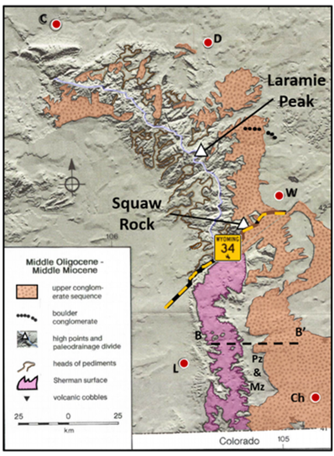
Geologic map showing extent of the Middle Tertiary upper conglomerate sequence and the Sherman erosion surface. Sherman surface is generally a flat erosion surface developed on Sherman Granite. Abbreviations: C = Casper; Ch = Cheyenne; D= Douglas; L = Laramie; W = Wheatland.
Image: After Evanoff, E., 2015, Field Trip Guide Middle to Late I Cenozoic Geology and Geomorphology of the Laramie Mountains, Wyoming: Colorado Scientific Society; http://coloscisoc.org/wp-content/uploads/2018/11/2015-Sept_Laramie_Mtns_WY_CSS_field_trip.pdf.
Image: After Evanoff, E., 2015, Field Trip Guide Middle to Late I Cenozoic Geology and Geomorphology of the Laramie Mountains, Wyoming: Colorado Scientific Society; http://coloscisoc.org/wp-content/uploads/2018/11/2015-Sept_Laramie_Mtns_WY_CSS_field_trip.pdf.
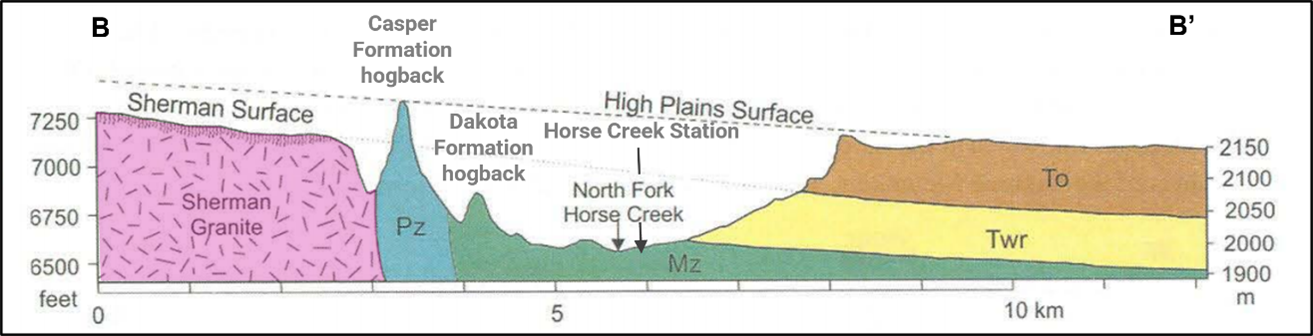
Cross section from the crystalline core of the Laramie Mountains to the High Plains. Location of cross section is on preceding map. The contact between the White River (Twr) and Ogallala (To) formations project to the Sherman surface, while the top of the High Plains surface project to the tops of the Casper Formation hogbacks. Mz and Pz on the diagram refer to Mesozoic and Paleozoic rocks, respectively.
Image: After Evanoff, E., 2015, Middle to Late Cenozoic Geology and Geomorphology of the Laramie Mountains, Wyoming, Field Trip Guide Colorado Scientific Society, Fig. 4, p. 6; 2015-Sept_Laramie_Mtns_WY_CSS_field_trip.pdf (coloscisoc.org).
Image: After Evanoff, E., 2015, Middle to Late Cenozoic Geology and Geomorphology of the Laramie Mountains, Wyoming, Field Trip Guide Colorado Scientific Society, Fig. 4, p. 6; 2015-Sept_Laramie_Mtns_WY_CSS_field_trip.pdf (coloscisoc.org).
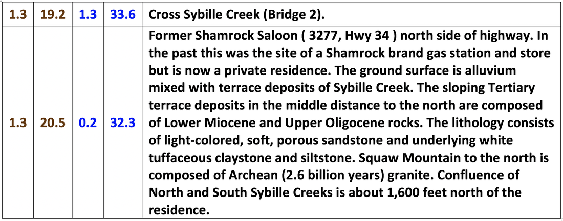
Sybille Creek bridge #2.
Image: Google Earth Street View
Image: Google Earth Street View
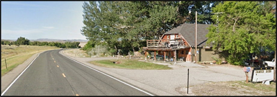
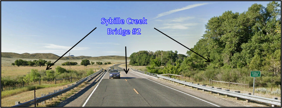
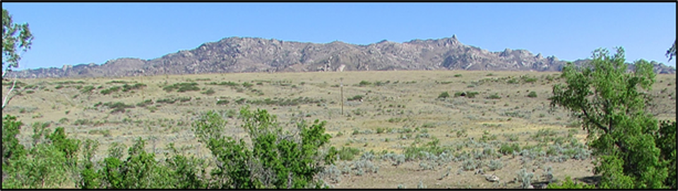
Former Shamrock Saloon.
Image: Google Earth Street View.
Image: Google Earth Street View.
Squaw Mountain granite outlier, east of Laramie Range.
Image: Google Earth Photos; https://lh5.googleusercontent.com/p/AF1QipNKrJHLVrXrZvGlsR-AUchz-B_2CU1nhHHz5iKw=h1440.
Image: Google Earth Photos; https://lh5.googleusercontent.com/p/AF1QipNKrJHLVrXrZvGlsR-AUchz-B_2CU1nhHHz5iKw=h1440.


South Sybille Creek bridge.
Image: Google Earth Street View.
Image: Google Earth Street View.

North aerial view of Red Mountain area. The featured is named for the red color of the weathered rock. Abbreviation: LPSZ = Laramie Peak Shear Zone.
Image: Google Earth
Image: Google Earth
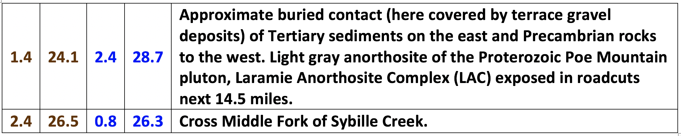
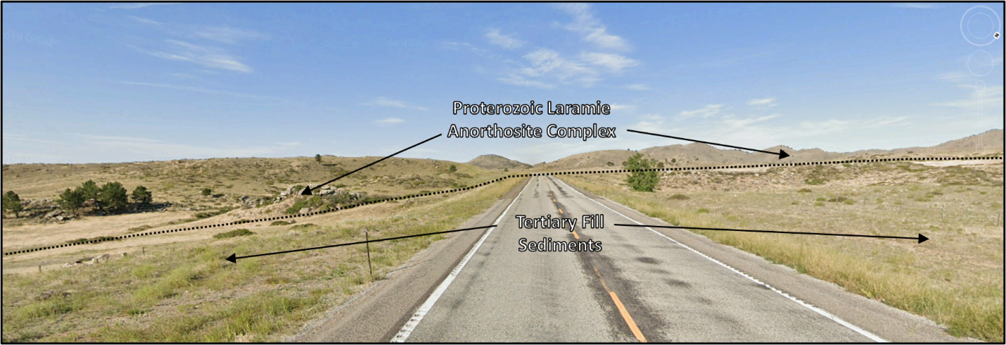
Approximate location of buried fault trace contact between Tertiary fill and Precambrian rock.
Image: Google Earth Street View.
Image: Google Earth Street View.
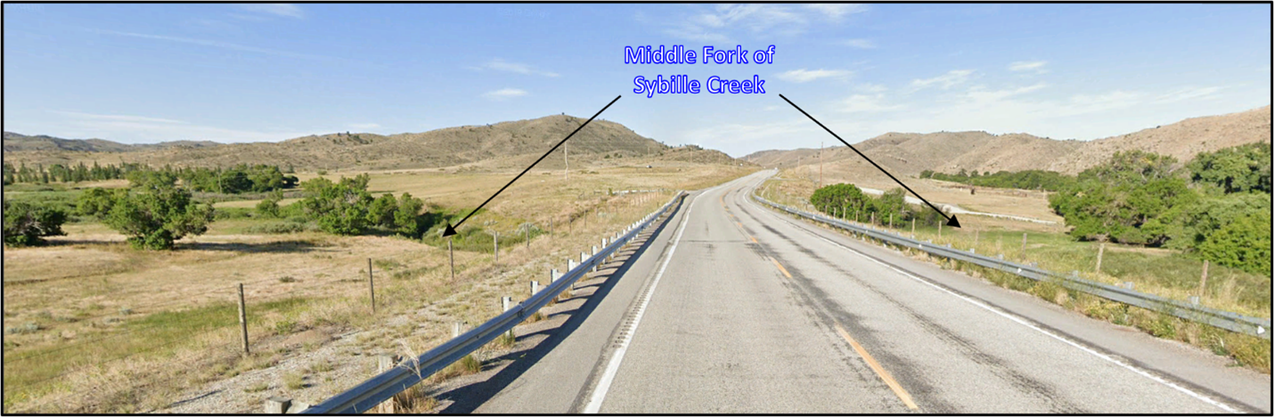
Middle Fork Sybille Creek.
Image: Google Earth Street View.
Image: Google Earth Street View.
A continent-volcanic arc collision named the Colorado Orogen (1.76-1.74 billion years ago) caused north-directed thrusts to bury the Proterozoic marginal basins (1.76-2.3 billion years) about 20 miles deep as it sutured onto the Wyoming craton. The stresses imparted by the collision and the weight from overlying rock layers generated temperatures and pressures that resulted in regional metamorphism. Crustal-thickening of the north-central Laramie Range by as much as 12.5 miles occurred during accretion and extended over 37 miles north of the suture zone. The Horse Creek Anorthosite Complex (1.74 billion years) intruded during the latter stages of this tectonism.
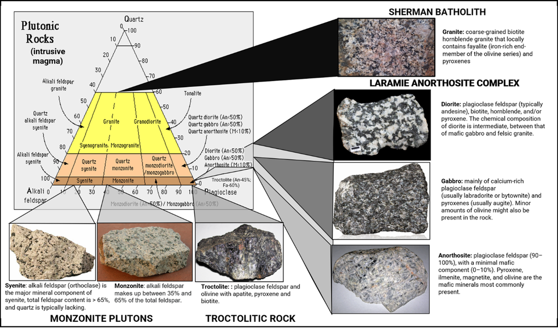
The Laramie Anorthosite Complex (1.44-1.43 billion years) intruded the Cheyenne Belt suture zone and generated contact metamorphism in the proximity of the intrusive bodies between the Cheyenne Belt and the Laramie Peak Shear zone. Anorthosite is a phaneritic (visible crystals) intrusive igneous rock (plutonic) composed of mostly calcium-rich plagioclase feldspar (90-100%) and minimal mafic minerals (0-10%). It is not common on earth but is the oldest rock type on the moon and a major rock of the lunar highlands (83%). Most terrestrial anorthosites are Proterozoic in age and occur in high-grade regional metamorphic terrains. The Laramie Anorthosite Complex consists of three main igneous intrusive rock types:
1) anorthosite plutons: coarse grained rock composed of calcium-rich plagioclase feldspar
Chugwater (1.435 billion years ago),
Poe Mt. (1.434 billion years ago),
Snow Creek ( ~1.433 billion years ago),
2) monzonite plutons: coarse-grained rock composed of both plagioclase feldspar and alkali feldspar
Red Mt. (1.432 billion years ago),
Maloin Ranch (1.43 billion years ago),
Sybille Intrusion (1.436 billion years ago),
3) troctolitic rock: mafic, coarse-grained rock that is composed almost entirely of olivine (often iron-rich) and plagioclase feldspar (labradorite or bytownite)
Strong Creek intrusion (1.43 billion years ago)
Greaser Creek intrusion (1.43 billion years ago).
Plutonic rock names are determined by the mineral percentages contained within the rock. The anorthositic complex is divided into lithologies based on amount and type of mafic (dark) and feldspar (light) minerals. The last major mountain building event, the Laramide Orogeny (70-55 Ma), elevated the Laramie Range and Laramie Anorthosite Complex by eastward directed thrusts.
Ternary diagram (Quartz-Alkali Feldspar-Plagioclase Feldspar) to classify plutonic rocks of the Laramie Anorthosite Complex area.
Image: Diagram: After http://ees2.geo.rpi.edu/pe1geo1_08/SS/lecture5/igneous_04c.html;
Granite: http://geoweb.uwyo.edu/ggstudent/cnauer/research.html;
Diorite: https://upload.wikimedia.org/wikipedia/commons/1/15/Diorite2.tif;
Gabbro: https://4.bp.blogspot.com/-PFbSeZ6WoTk/VQlxpFye_6I/AAAAAAAAAQc/adNJUUreG5w/s1600/Gabbro3_hero_mod.jpg;
Anorthosite: https://www.flickr.com/photos/47445767@N05/50421871477/;
Troctolite: https://www.flickr.com/photos/jsjgeology/51143336871;
Monzonite: https://en.m.wikipedia.org/wiki/Monzonite;
Syenite: https://flexiblelearning.auckland.ac.nz/rocks_minerals/rocks/syenite.html
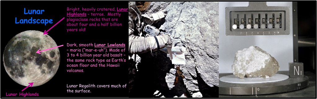
Left: landscape of the moon. Center: Apollo 16 astronaut Charlie Duke samples a house-sized boulder of anorthosite on the rim of North Ray Crater in the Descartes Lunar Highlands. Right: Apollo 15 anorthosite “Genesis Rock” collected by astronauts David Scott and Jim Irwin. The rock was name due to scientists initially thinking they had found a piece of the Moon's primordial crust, but later analysis showed that the rock was only 4.1 ± 0.1 billion years old, which is younger than the Moon itself, and was formed after the Moon's crust solidified. It is still an extremely old sample, formed during the Pre-Nectarian period of the Moon's history. Dating of pyroxenes from other lunar anorthosite samples gave a samarium–neodymium age of crystallization of 4.46 billion years.
Image: Left: https://www.slideshare.net/TUSHARGIRI6/geology-of-moon; Center & Right:https://www.geocaching.com/geocache/GC5KAPD_planetary-geology-on-earth-sangabriel-anorthosite?guid=bd9350dd-c179-457a-9b29-1dfbfd6d550e.
Image: Left: https://www.slideshare.net/TUSHARGIRI6/geology-of-moon; Center & Right:https://www.geocaching.com/geocache/GC5KAPD_planetary-geology-on-earth-sangabriel-anorthosite?guid=bd9350dd-c179-457a-9b29-1dfbfd6d550e.
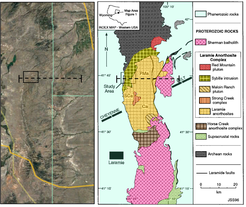
Areial view (left) and geologic map (right) of the southern Laramie Mountains in southeastern Wyoming showing the location of the 1.43 billion year old Laramie Anorthosite Complex. Archean rocks of the Wyoming province crop out to the north of the complex, and Proterozoic rocks crop out to the south. The approximate trend of the Cheyenne belt is indicated by the thick dashed line. It is a 5-km-wide mylonitic shear zone, the boundary separating Archean and Proterozoic crustal rocks beneath the younger Laramie Anorthosite Complex and the much younger Phanerozoic rocks. The central area of the complex is occupied by three large, composite, anorthositic intrusions: the Poe Mountain (PMa), Chugwater (Ca), and Snow Creek anorthosites (SCa) (Mitchell et al., 1995; Scoates and Chamberlain, 1995). Monzonitic rocks are the predominant lithology contained in three large intrusions that occur along the margins of the anorthositic intrusions: the Maloin Ranch pluton in the southeast, the Sybille intrusion in the northwest, and the Red Mountain pluton in the northeast. The older, 1.76 billion year Horse Creek anorthosite complex (Scoates et al., 1993a; Scoates, 1994) is situated a few kilometers to the south of the Laramie Anorthosite Complex.
Image: Left: Google Earth. Right: After Scoates, J., C. Frost, J. N. Mitchell, D. Lindsley and B. Frost, 1996, Residual-liquid origin for a monzonitic intrusion in a mid-Proterozoic anorthosite complex: The Sybille intrusion, Laramie anorthosite complex, Wyoming: Geological Society of America Bulletin Vol. 108, No. 11, Fig. 1, p. 1358; https://www.researchgate.net/publication/255686938_Residual-liquid_origin_for_a_monzonitic_intrusion_in_a_mid-Proterozoic_anorthosite_complex_The_Sybille_intrusion_Laramie_anorthosite_complex_Wyoming.
Image: Left: Google Earth. Right: After Scoates, J., C. Frost, J. N. Mitchell, D. Lindsley and B. Frost, 1996, Residual-liquid origin for a monzonitic intrusion in a mid-Proterozoic anorthosite complex: The Sybille intrusion, Laramie anorthosite complex, Wyoming: Geological Society of America Bulletin Vol. 108, No. 11, Fig. 1, p. 1358; https://www.researchgate.net/publication/255686938_Residual-liquid_origin_for_a_monzonitic_intrusion_in_a_mid-Proterozoic_anorthosite_complex_The_Sybille_intrusion_Laramie_anorthosite_complex_Wyoming.
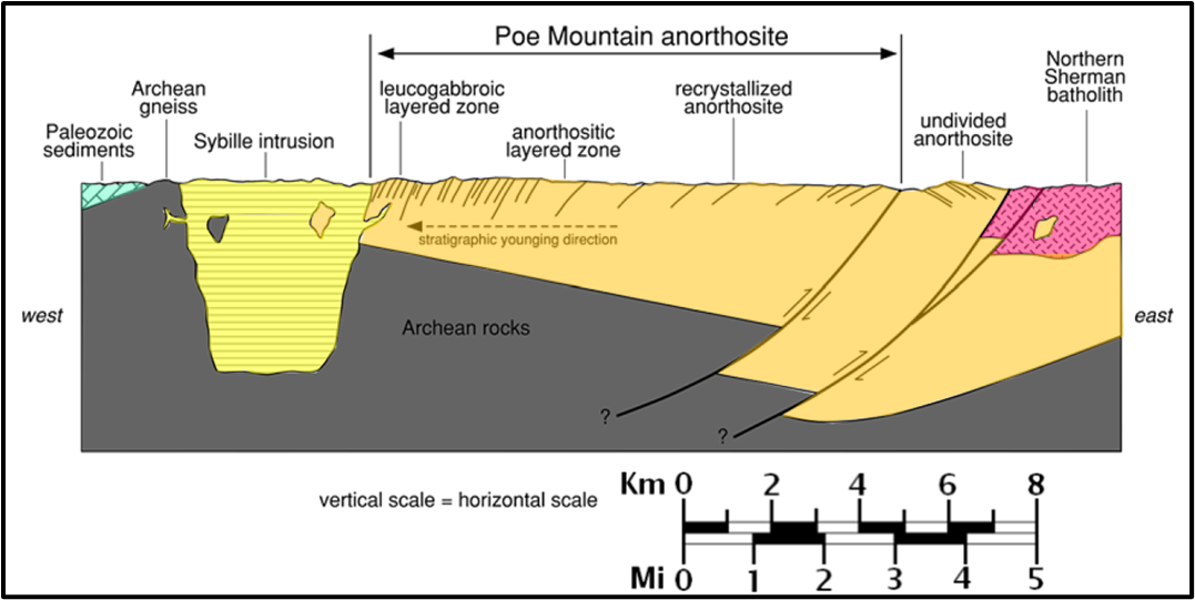
Simplified E–W cross-section across intrusions (location of the section shown on map above and below) with no vertical exaggeration through the northern part of the Laramie Anorthosite Complex, interpreted from results of seismic reflection profiles (Allmendinger et al. 1982, Brewer et al. 1982, Speece et al. 1994), gravity studies (Hodge et al. 1973), and map relationships of the anorthositic and monzosyenitic (the prefix “monzo” means that there are significant amount of both alkali and plagioclase feldspars in the syenite rock) intrusions. The section was chosen to be as close as possible to the northernmost E–W seismic reflection profile (line 5) from Brewer et al. (1982) for control on structure at depth; as a result, it is slightly south of the lowermost Anorthositic Layered Zone and core of the Poe Mountain anorthosite (these parts of the intrusion are projected to the section line). Thin, black lines indicate orientations of magmatic structures (layering, lamination) and deformation fabrics within the Poe Mountain anorthosite. The stratigraphic younging direction is from the core to the margins.
Image: After Scoates, J.S., Lindsley, D.H., Frost, R.B., 2010, Magmatic and structural evolution of an anorthositic magma
chamber: The Poe mountain intrusion, Laramie Anorthosite complex, Wyoming: The Canadian Mineralogist, Vol. 48, Fig. 2, p. 855; https://www.researchgate.net/publication/274419628_Magmatic_and_structural_evolution_of_an_anorthositic_magma_chamber_The_Poe_mountain_intrusion_Laramie_Anorthosite_complex_Wyoming.

Left: Simplified geological map of the northern part of the Laramie Anorthosite Complex. The layered series of the Poe Mountain anorthosite is subdivided into a lower, middle, and upper anorthositic layered zone (ALZ) and a lower and upper leucogabbroic layered zone (LLZ; the prefix “leuco” indicates a gabbro lighter in color than a normal gabbro owing to the presence of a larger amount of feldspar than usual). The contact between the ALZ and LLZ is shown as a solid line, and internal subdivisions are shown as dashed lines. Layering and lamination dip 30–60° to the west and north in the inner parts of the intrusion, and 60–90° along the upper and outer portions. The region to the east of the major N–S fault is referred to as “Undivided Anorthosite”; insufficient mapping has been completed in this area to assign these rocks to a specific intrusive phase. The short-dashed line indicates the location of the cross-section. WY-34 is the Wyoming State Highway that follows Sybille Canyon and cuts across the Poe Mountain anorthosite. Geographic locators include SR: Sheep Rock (7,280 feet, 2,220 meters above sea level), CC: Conservation Center, JR: Johnson Reservoir, SP: Sybille Pit (Fe–Ti oxide deposit), PM: Poe Mountain (7,126 feet, 2,172 meters above sea level). For reference, the cross in the center of the figure shows the intersection (41°45’N, 105°22’30”W) of four United States Geological Survey topographic quadrangles (1:24,000 scale): 1: Guide Rock, 2: Poe Mountain, 3: Indian Guide, 4: Sheep Rock.
Right: Landsat 5 satellite images of the Laramie Anorthosite Complex and Poe Mountain intrusion. Images extracted and processed from Scene LT5034031000229410 (Path: 034, Row: 031, Date of Acquisition: October 21, 2002). Satellite image covering the same area as the geological map shown on left. The boxes with white dashed lines outline areas where megascopic layers occur; these megascopic layers are represented by layered units either dominated by plagioclase-rich layers (resistant) or by more mafic-rich layers (recessive). The contacts of the layered units are parallel to the orientation of the long axis of the boxes. For reference, the trace of Wyoming State Highway 34 is shown (solid white line).
Image: After Scoates, J.S., Lindsley, D.H., Frost, R.B., 2010, Magmatic and structural evolution of an anorthositic magma
chamber: The Poe mountain intrusion, Laramie Anorthosite complex, Wyoming: The Canadian Mineralogist, Vol. 48, Fig. 3 & 4B, p. 857; https://www.researchgate.net/publication/274419628_Magmatic_and_structural_evolution_of_an_anorthositic_magma_chamber_The_Poe_mountain_intrusion_Laramie_Anorthosite_complex_Wyoming.
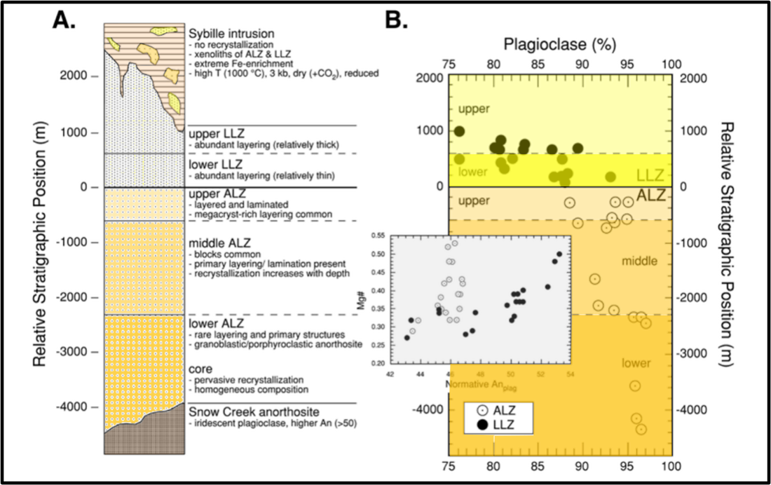
Idealized stratigraphic sections through the Poe Mountain anorthosite. A. Schematic stratigraphic column showing major subdivisions of the layered series and the general characteristics of each subdivision. The relative stratigraphic position (RSP) indicates the relative distance of mapped contacts and samples at locations perpendicular to the ALZ–LLZ contact; it is not a true stratigraphic thickness, as no correction has been applied for the variable dips of layers in the anorthositic rocks. B. RSP versus plagioclase abundance in the layered series (same scale as in panel A). The percent plagioclase equals the sum of the cation standard feldspar components (An + Ab + Or) of whole-rock samples (data from Scoates 1994). There are systematic shifts in plagioclase abundance at each of the major subdivisions in the Poe Mountain anorthosite. The inset shows the relationship for whole rocks between the normative anorthite content of plagioclase [Anpl = An/(An + Ab + Or), Mg# = Mg/(Mg + Fe2+total)]; data from Scoates (1994). Note the restricted range of Mg# for rocks of the ALZ relative to those of the LLZ.
Image: After Scoates, J.S., Lindsley, D.H., Frost, R.B., 2010, Magmatic and structural evolution of an anorthositic magma
chamber: The Poe mountain intrusion, Laramie Anorthosite complex, Wyoming: The Canadian Mineralogist, Vol. 48, Fig. 5, p. 859; https://www.researchgate.net/publication/274419628_Magmatic_and_structural_evolution_of_an_anorthositic_magma_chamber_The_Poe_mountain_intrusion_Laramie_Anorthosite_complex_Wyoming.
Light gray anorthosite in roadcuts.
Image: Google Earth Street View.
Image: Google Earth Street View.

North Fork Sybille Creek bridge.
Image: Google Earth Street View.
Image: Google Earth Street View.
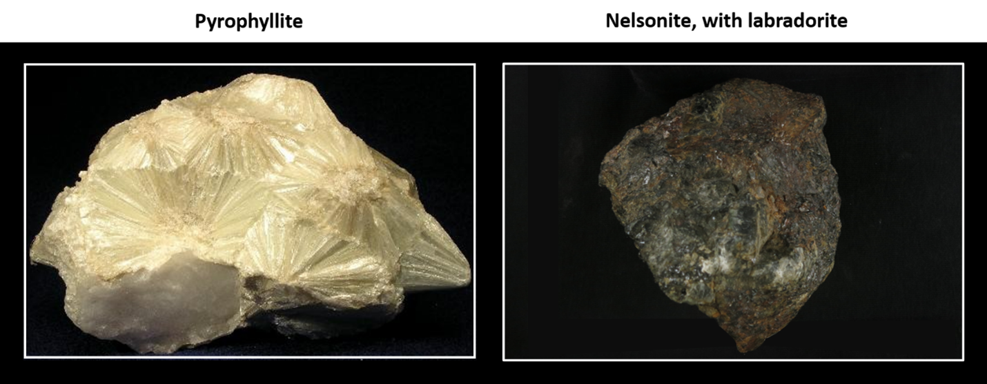
Samples found at the Sybille Pit (Latitude: 41.7783°, Longitude: -105.3515°).
Image: Left: https://upload.wikimedia.org/wikipedia/commons/b/b2/Pyrophyllite-118706.jpg; Right: https://sio-gtc.s3.amazonaws.com/photos/GRD02SJP0.JPG.
Image: Left: https://upload.wikimedia.org/wikipedia/commons/b/b2/Pyrophyllite-118706.jpg; Right: https://sio-gtc.s3.amazonaws.com/photos/GRD02SJP0.JPG.
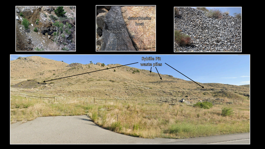
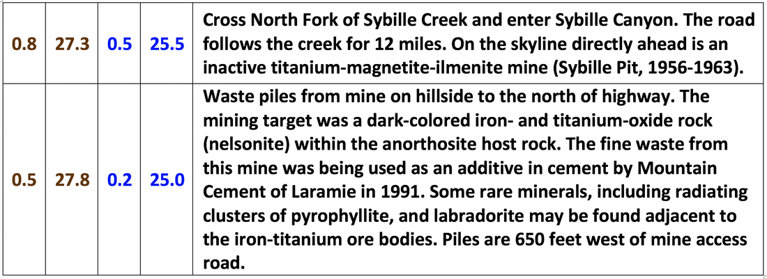
Top Left: Sybille Pit mine and waste piles. This is an old, inactive titanium mine in Wyoming's Laramie Range. Top Middle: The dark-colored rocks were the mining target - these are iron- and titanium-oxide rocks, referred to as nelsonites. Nelsonites are scarce intrusive igneous rocks. Also known as FTP rocks, in reference to their composition, nelsonites are iron-rich (Fe), titanium-rich (Ti), and phosphorus-rich (P). They are principally composed of dark gray to blackish, metallic-lustered magnetite (Fe3O4) and ilmenite (FeTiO3) (or ilmenomagnetite (magnetite with a microscopic ingrowth of ilmenite); also, titanium magnetite(oxides of titanium and iron)), plus apatite (CaPO4). Minor minerals reported in nelsonites include spinel, olivine, pyrrhotite, and graphite. Top Right: Gravel pile is waste piles from mine operation, north side of road. Gravel is composed of grayish anorthosite and some blackish nelsonite. Anorthosite is an uncommon intrusive igneous rock composed principally of sodic to calcic plagioclase feldspar, usually with minor pyroxene. Anorthosite is not common on Earth but is abundant on the Moon. Nelsonite is a scarce intrusive igneous rock composed of magnetite, ilmenite, and apatite. Bottom: Waste on hillside north of highway.
Image: Top Left: https://www.flickr.com/photos/jsjgeology/50500383188/;
Top Middle: https://www.flickr.com/photos/jsjgeology/50501242937/in/photostream/;
Top Right: https://www.flickr.com/photos/jsjgeology/50419419947/in/album-72157674531714314/
Bottom: Google Earth Street View.
Image: Top Left: https://www.flickr.com/photos/jsjgeology/50500383188/;
Top Middle: https://www.flickr.com/photos/jsjgeology/50501242937/in/photostream/;
Top Right: https://www.flickr.com/photos/jsjgeology/50419419947/in/album-72157674531714314/
Bottom: Google Earth Street View.

Johnson Creek and canyon road to reservoir.
Image: Google Earth Street View.
Image: Google Earth Street View.
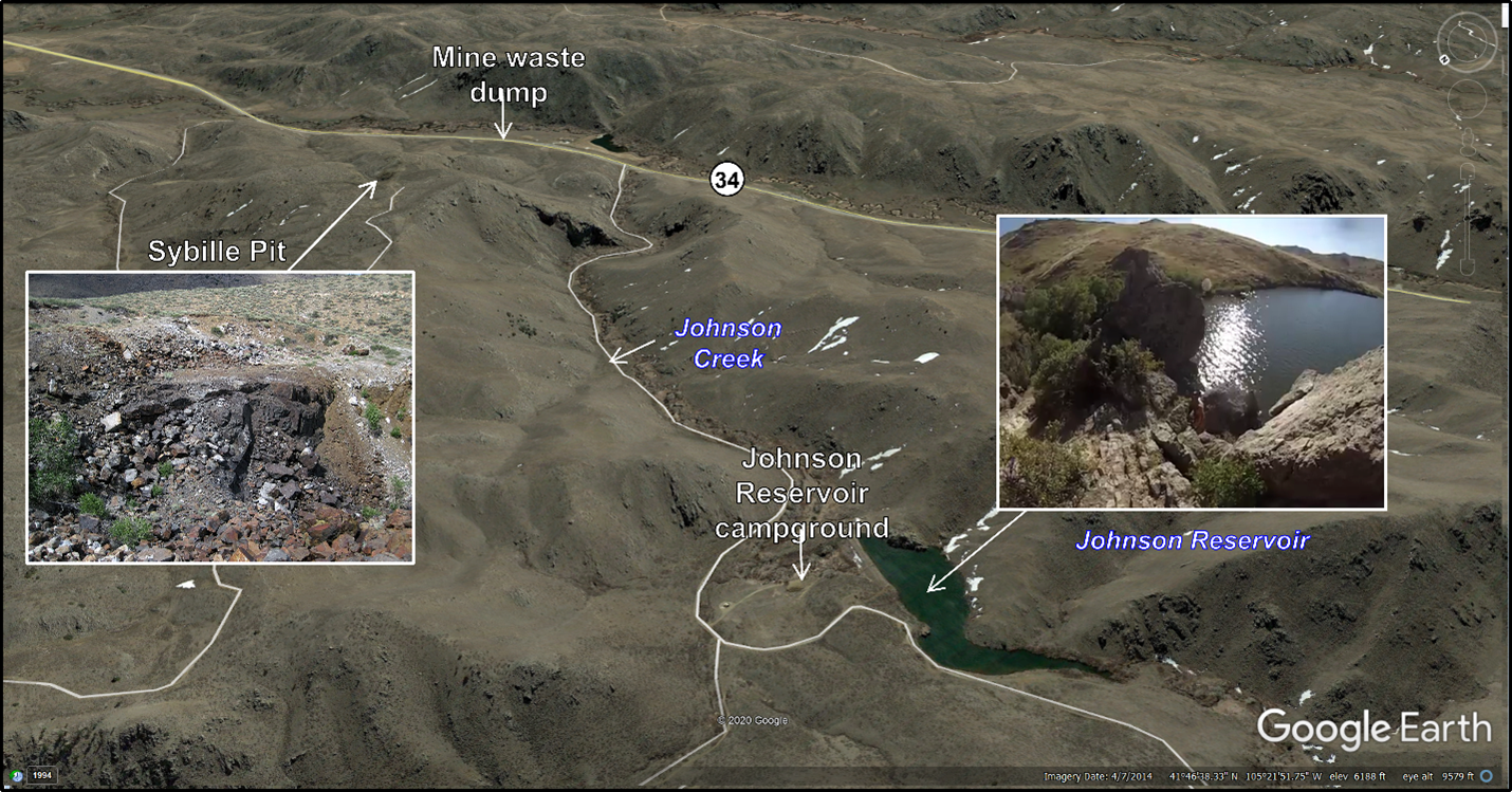
Southeast aerial view of Sybille Pit, Johnson Creek canyon and campground area.
Image: Google Earth. Sybille Pit: Titanium_mine_(Laramie_Anorthosite_Complex,_Mesoproterozoic,_1.43_Ga;_Sybille_Pit,_Laramie_Range,_Wyoming,_USA)_5.jpg (3968×2976) (wikimedia.org); Johnson Reservoir: Fernandez, A., 2014, Cliff Diving at Johnson Reservoir screen capture; https://m.youtube.com/watch?v=K49BcnWatj0.
Image: Google Earth. Sybille Pit: Titanium_mine_(Laramie_Anorthosite_Complex,_Mesoproterozoic,_1.43_Ga;_Sybille_Pit,_Laramie_Range,_Wyoming,_USA)_5.jpg (3968×2976) (wikimedia.org); Johnson Reservoir: Fernandez, A., 2014, Cliff Diving at Johnson Reservoir screen capture; https://m.youtube.com/watch?v=K49BcnWatj0.

Recrystallized core of Poe Mountain anorthosite.
Image: After Google Earth Street View.
Image: After Google Earth Street View.

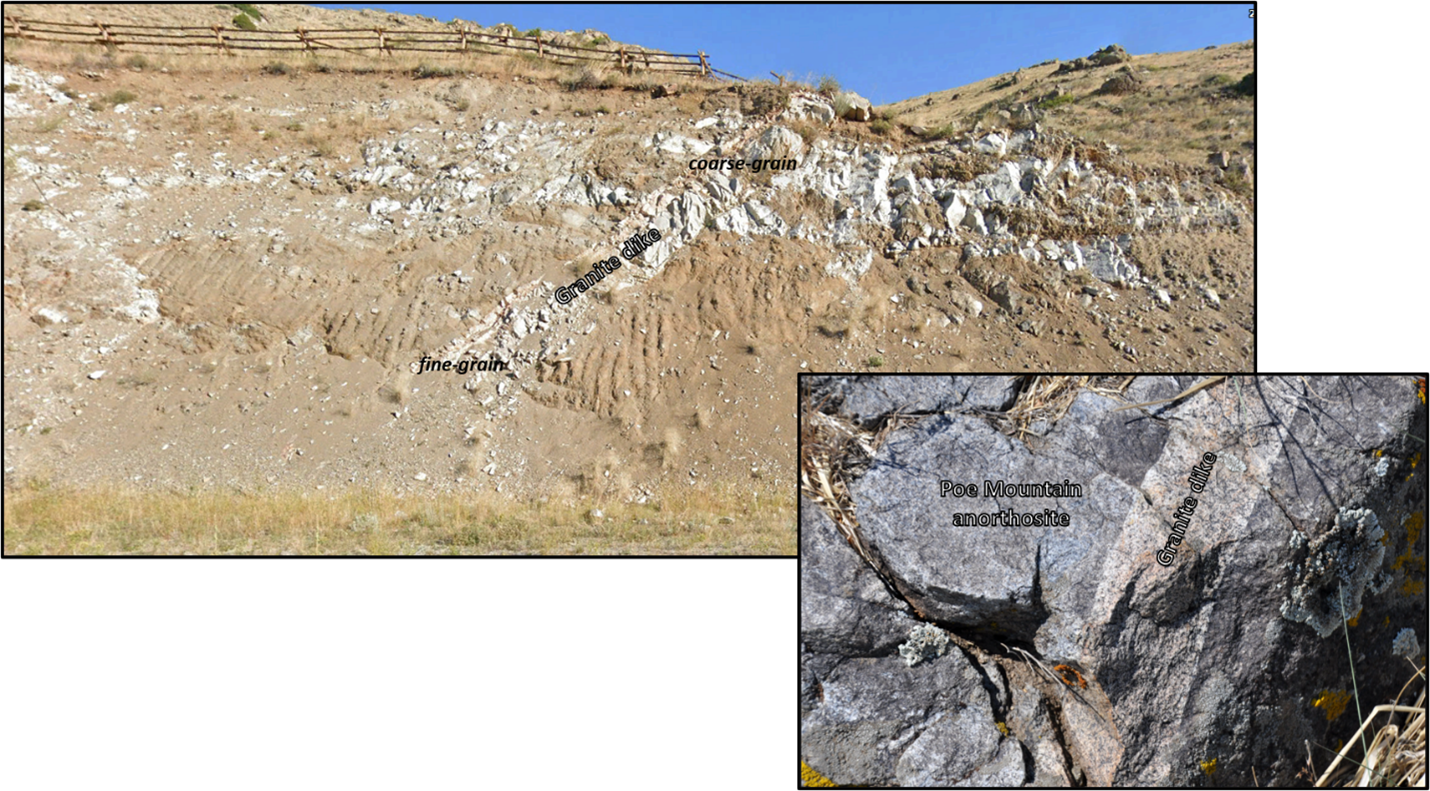
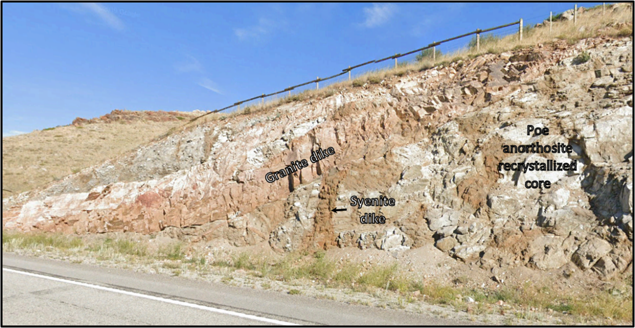
Granite dike in Poe Mountain pluton.
Image: Google Earth Street View
Image: Google Earth Street View
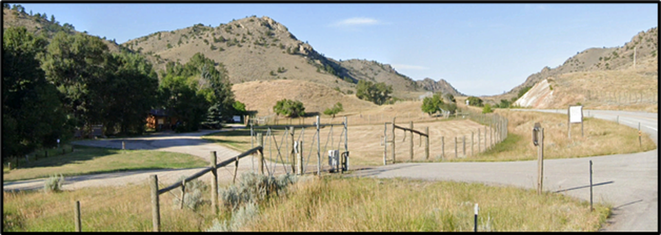
Tom Thorne and Beth Williams Wildlife Research Center at Sybille.
Image: Google Earth.
Image: Google Earth.

Left: Aerial view of Thorne and Williams Wildlife Experimental Unit, Right: Wyoming Game and Fish Wildlife Center original breeding facility for black-footed ferrets.
Image: Left: Google Earth and Earth Point Topo Map;
Right: Peterson, C., 2017, Casper Star-Tribune; https://trib.com/outdoors/game-and-fish-research-station-tackles-tough-wildlife-problems/article_083103d5-e345-5035-9a43-4dc502b1e1a4.html.
Image: Left: Google Earth and Earth Point Topo Map;
Right: Peterson, C., 2017, Casper Star-Tribune; https://trib.com/outdoors/game-and-fish-research-station-tackles-tough-wildlife-problems/article_083103d5-e345-5035-9a43-4dc502b1e1a4.html.
Location of 1984 rockfall.
Image: After Google Earth.
Image: After Google Earth.

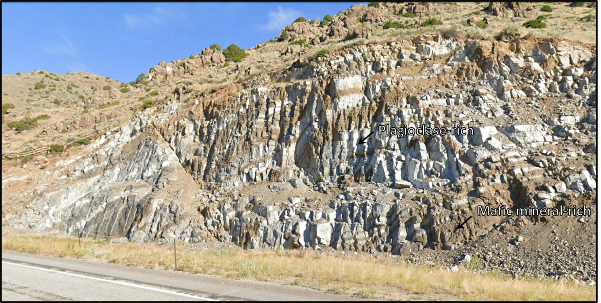
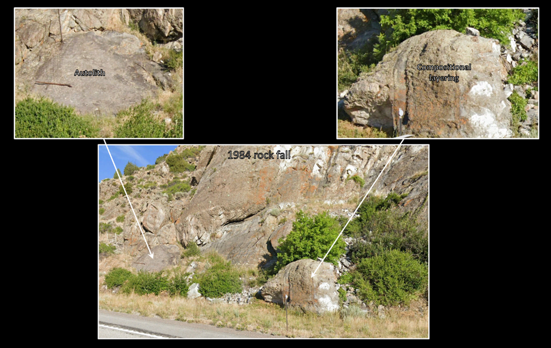
Outcrop displaying compositional layering of Poe anorthosite.
Image: After Google Earth.
Image: After Google Earth.

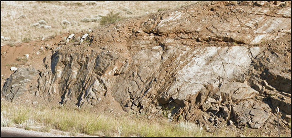
Fine layering in anorthosite.
Image: After Google Earth Street View.
Image: After Google Earth Street View.

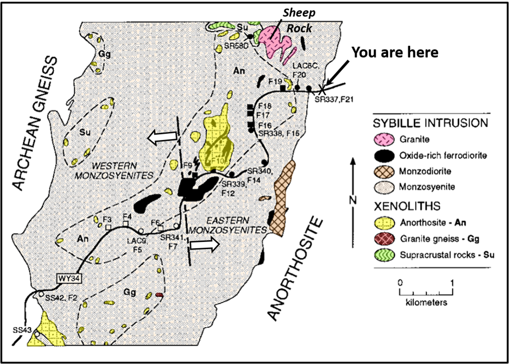
Geologic map of the Sybille Intrusion area along Wyoming State Highway 34 (WY34) in the southern part of the Sybille intrusion. The dominant lithology is coarse-grained monzosyenite, with minor intrusions of oxide-rich ferrodiorite, monzodiorite, and granite. Xenoliths occur throughout the study area and can be grouped (areas surrounded by dashed lines) geographically according to lithology: An = anorthosite, Gg = granite gneiss, and Su = supracrustal rocks. The inferred contact between eastern and western monzosyenite (thick, alternating short-dashed and long-dashed line with white arrows) is based on geochemical characteristics.
Image: After Scoates, J., Frost, C., Mitchell, J., Lindsley, D., & Frost, B., 1996, Residual-liquid origin for a monzonitic intrusion in a mid-Proterozoic anorthosite complex: The Sybille intrusion, Laramie anorthosite complex, Wyoming. Geological Society of America Bulletin Vol. 108, No. 11, Fig. 3, p. 1360.; https://www.researchgate.net/publication/255686938_Residual-liquid_origin_for_a_monzonitic_intrusion_in_a_mid-Proterozoic_anorthosite_complex_The_Sybille_intrusion_Laramie_anorthosite_complex_Wyoming.
Image: After Scoates, J., Frost, C., Mitchell, J., Lindsley, D., & Frost, B., 1996, Residual-liquid origin for a monzonitic intrusion in a mid-Proterozoic anorthosite complex: The Sybille intrusion, Laramie anorthosite complex, Wyoming. Geological Society of America Bulletin Vol. 108, No. 11, Fig. 3, p. 1360.; https://www.researchgate.net/publication/255686938_Residual-liquid_origin_for_a_monzonitic_intrusion_in_a_mid-Proterozoic_anorthosite_complex_The_Sybille_intrusion_Laramie_anorthosite_complex_Wyoming.
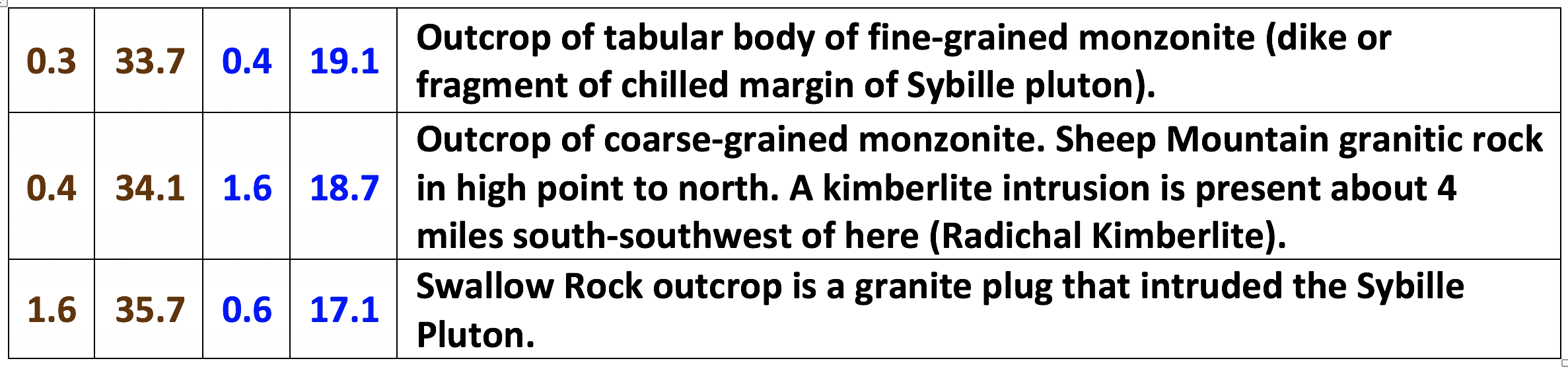
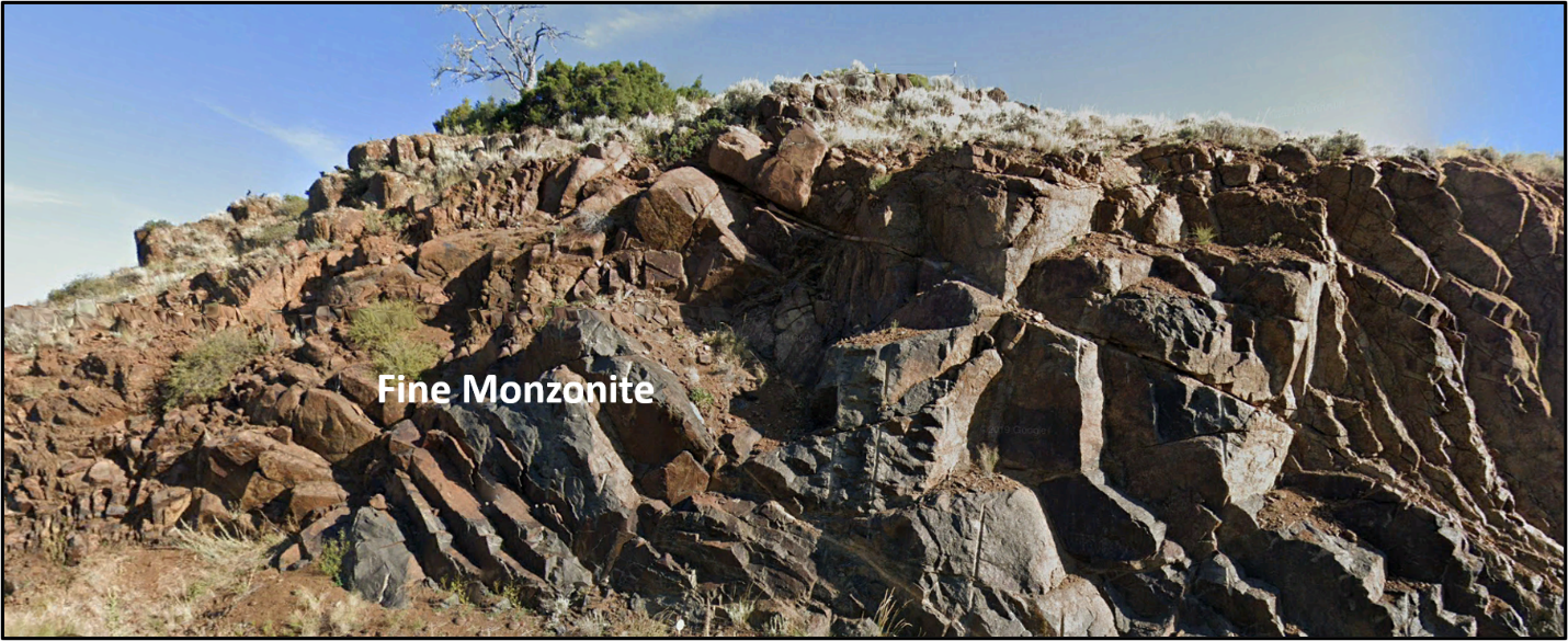
Fine-grained monzonite outcrop.
Image: After Google Earth.
Image: After Google Earth.
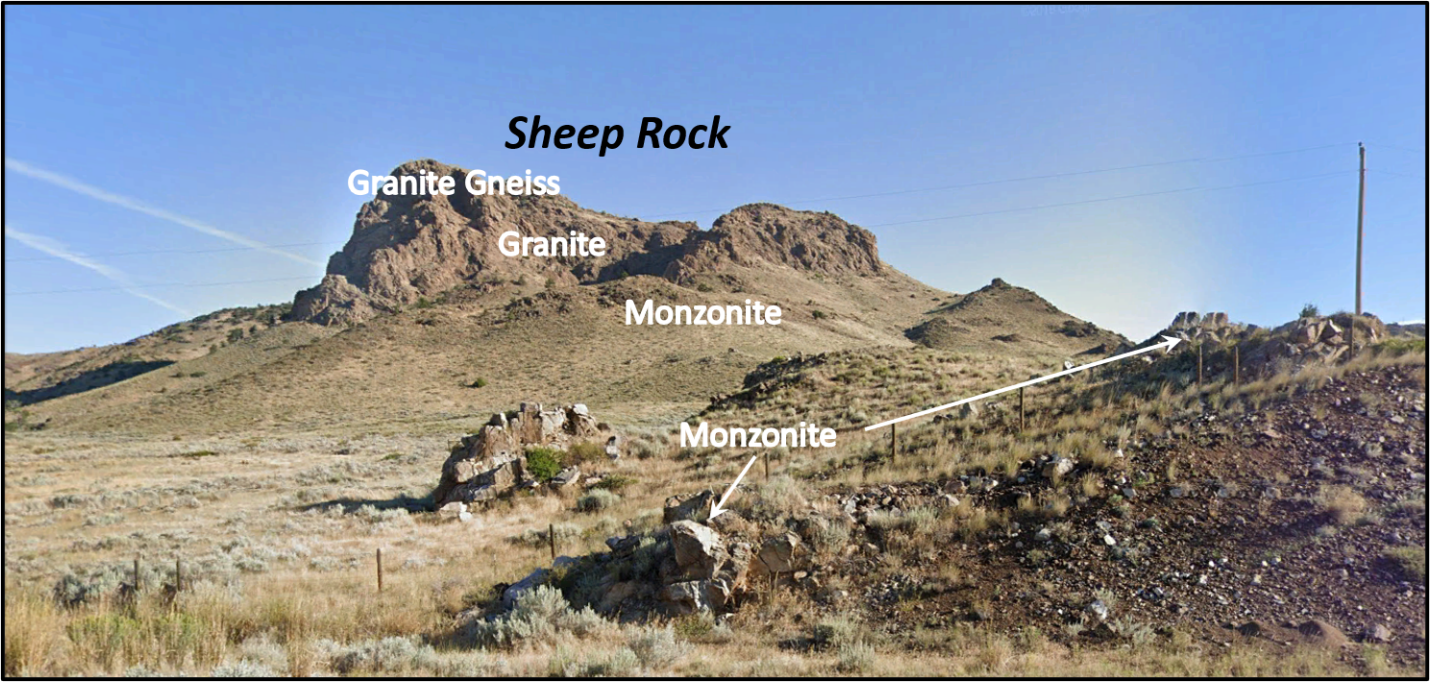
Sheep Rock outcrop north of highway.
Image: After Google Earth Street View.
Image: After Google Earth Street View.
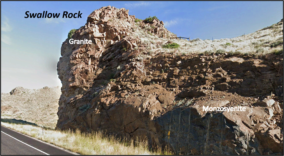
Swallow Rock granite plug.
Image: After Google Earth Street View.
Image: After Google Earth Street View.


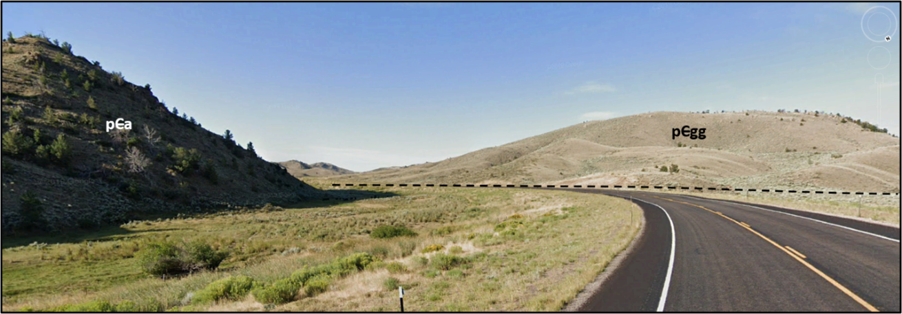
South-southwest view of normal fault separating Laramie anorthosite complex (pca) from granite-gneiss rocks (pcgg).
Image: After Google Earth Street View.
Image: After Google Earth Street View.

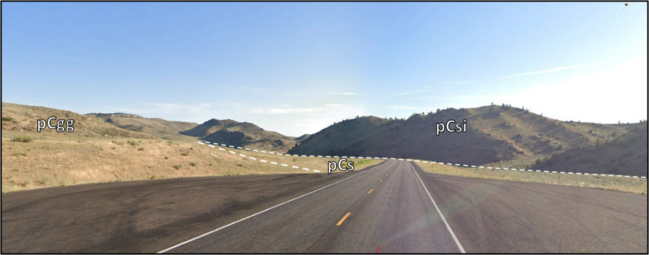
North view of valley composed of supracrustal schist valley separating Archean granite gneiss (left), and Proterozoic Sybille pluton (right). Geologic notation: pCgg = Precambrian Archean granite gneiss; pCs = Precambrian Archean schist; pCsi = Precambrian Proterozoic Sybille intrusion.
Image: Google Earth Street View
Image: Google Earth Street View
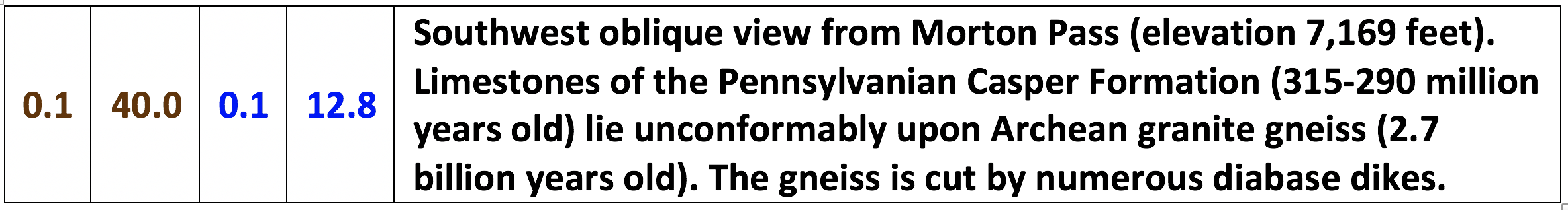
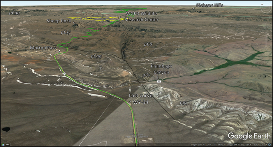
North aerial view of Morton Pass area.
Image: Google Earth.
Image: Google Earth.
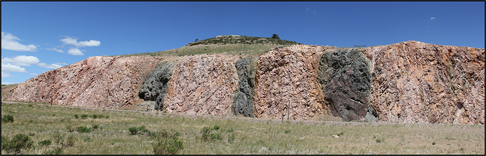
Road cut outcrop at left exposes 2.1 billion-year-old mafic dikes (black diabasic amphibolite) intruding older Archean granitic gneisses (pink) that are 2.7 billion years old. View is to the north.
Image: https://blogs.agu.org/mountainbeltway/files/2013/06/dikes.jpg.
Image: https://blogs.agu.org/mountainbeltway/files/2013/06/dikes.jpg.
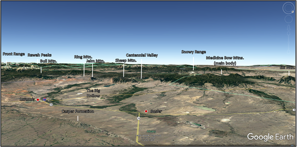
Southwest aerial panorama of Medicine Bow Mountains in distance; include (from north or right) Elk Mountain, the main body of the Medicine Bow Mountains with the Snowy Range at the top, Centennial Valley, Sheep Mountain (massive ridge directly ahead), Jelm Mountain (pointed peak left of Sheep Mountain), Ring Mountain, Bull Mountain with prominent saddle), the Rawah Peaks section of the Medicine Bow Mountains on the skyline, and the peaks of the Colorado Front Range on the skyline to the south.
Image: Google Earth.
Image: Google Earth.
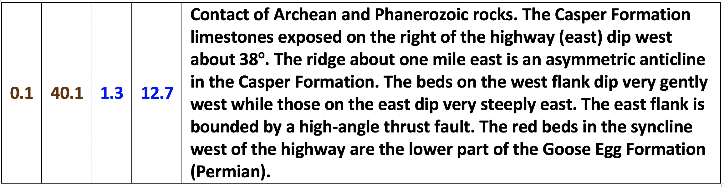

Southwest view of Triassic-Permian Goose Egg Formation, west of highway.
Image: After Google Earth Street View.
Image: After Google Earth Street View.
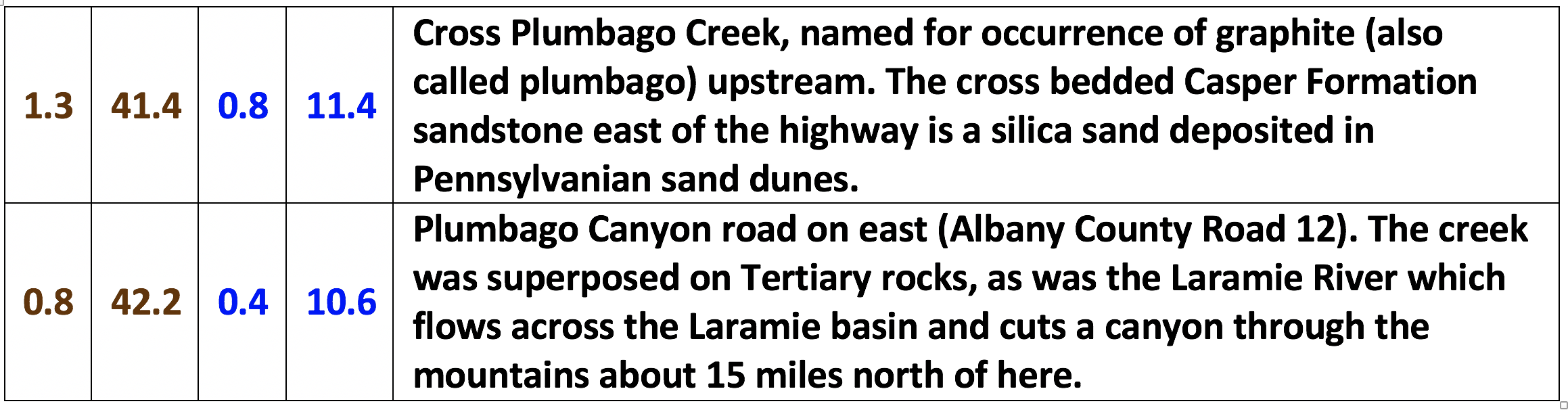
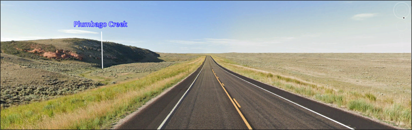
Crossing over Plumbago Creek, the headwaters of North Sybille Creek.
Image: After Google Earth Street View.
Image: After Google Earth Street View.
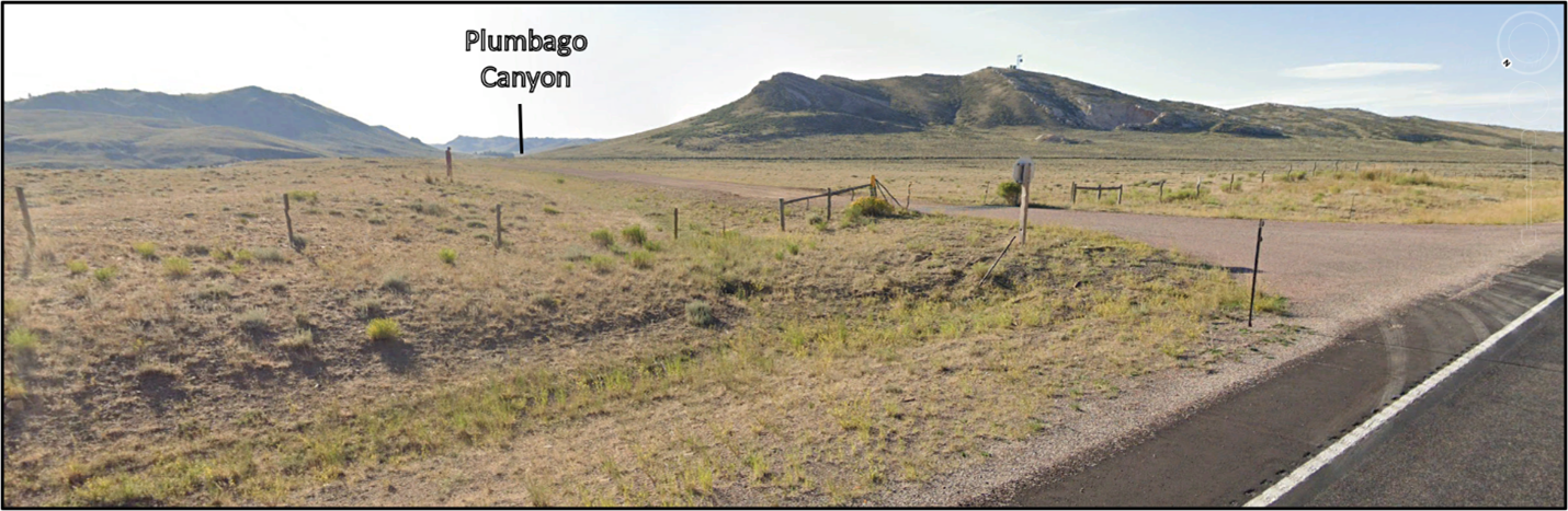
Junction of Sybille Road to east into Plumbago Canyon.
Image: After Google Earth Street View.
Image: After Google Earth Street View.

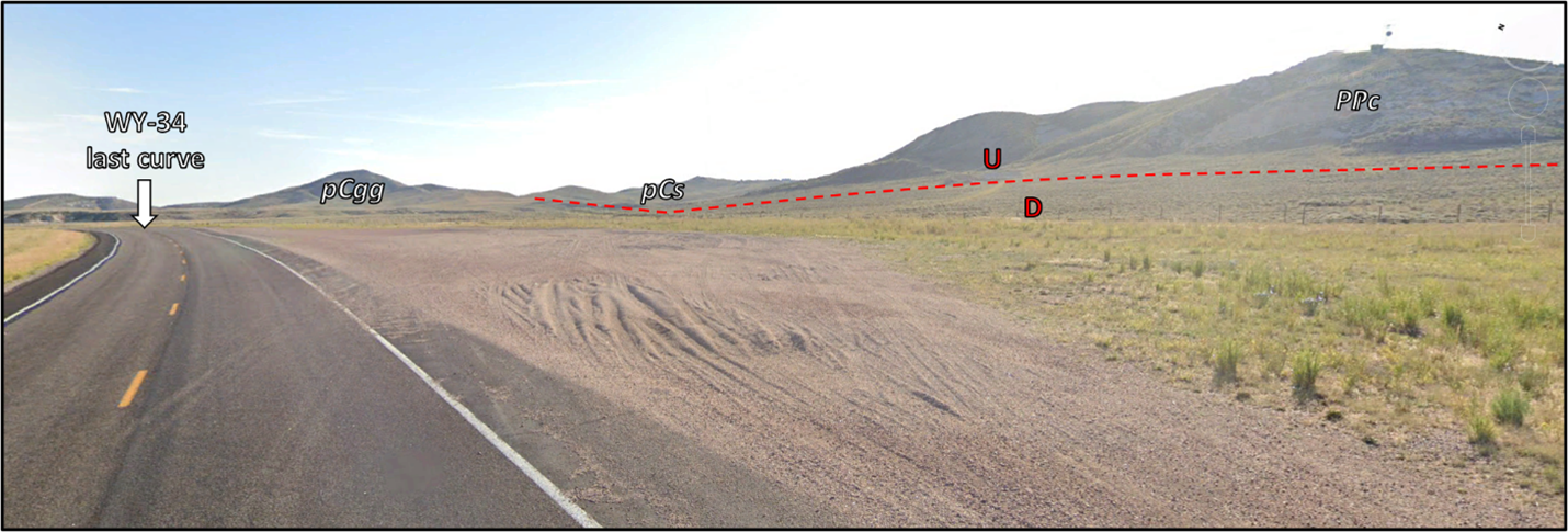
Northeast aerial view of last curve in Wyoming Highway 34. View is to the northeast. Geologic notation: pCa = Precambrian Proterozoic anorthosite; pCgg = Precambrian Archean granite gneiss; pCs = Precambrian Archean supracrustal metasediments; pCsy = Precambrian Proterozoic Sybille intrusion; PPc = Permian-Pennsylvanian Casper Formation.
Image: Google Earth.
Image: Google Earth.
Northeast view of last curve on Wyoming Highway 34. Geologic notation: pCgg = Precambrian Archean granite gneiss; pCs = Precambrian Archean supracrustal metasediments; PPc = Permian-Pennsylvanian Casper Formation.
Image: After Google Earth Street View.
Image: After Google Earth Street View.


Afterword
The Wyoming State Geological Survey has recently published a geologic map that covers the WY-34 road log route through Sybille Canyon. You can access here:
https://sales.wsgs.wyo.gov/preliminary-geologic-map-of-the-rock-river-30-x-60-quadrangle-albany-laramie-and-platte-counties-wyoming-2021/.
https://sales.wsgs.wyo.gov/preliminary-geologic-map-of-the-rock-river-30-x-60-quadrangle-albany-laramie-and-platte-counties-wyoming-2021/.
Geology Map of Rock River Quadrangle
Image: After Stafford, J.E., Hoffman, C.F., Wittke, S.J., Webber, P.M., and Frost, B.R., 2021, Preliminary geologic map of the Rock River 30' x 60' quadrangle, Albany, Laramie, and Platte counties, Wyoming: Wyoming State Geological Survey Open File Report 2021-5, scale 1:100,000; https://sales.wsgs.wyo.gov/preliminary-geologic-map-of-the-rock-river-30-x-60-quadrangle-albany-laramie-and-platte-counties-wyoming-2021/
Image: After Stafford, J.E., Hoffman, C.F., Wittke, S.J., Webber, P.M., and Frost, B.R., 2021, Preliminary geologic map of the Rock River 30' x 60' quadrangle, Albany, Laramie, and Platte counties, Wyoming: Wyoming State Geological Survey Open File Report 2021-5, scale 1:100,000; https://sales.wsgs.wyo.gov/preliminary-geologic-map-of-the-rock-river-30-x-60-quadrangle-albany-laramie-and-platte-counties-wyoming-2021/
The region has hosted many decorative stone quarries from Precambrian rock. Rock quarries have been in operation since the Flintstone-age.

Bedrock rock quarry.
Image: Left: https://www.pinterest.com/pin/604537949956937583/;
Right: https://www.chicagotribune.com/suburbs/post-tribune/opinion/ct-ptb-potempa-column-st-1119-20201118-dudfnkktzjgefmdknmnk7dzz54-story.html.
Image: Left: https://www.pinterest.com/pin/604537949956937583/;
Right: https://www.chicagotribune.com/suburbs/post-tribune/opinion/ct-ptb-potempa-column-st-1119-20201118-dudfnkktzjgefmdknmnk7dzz54-story.html.
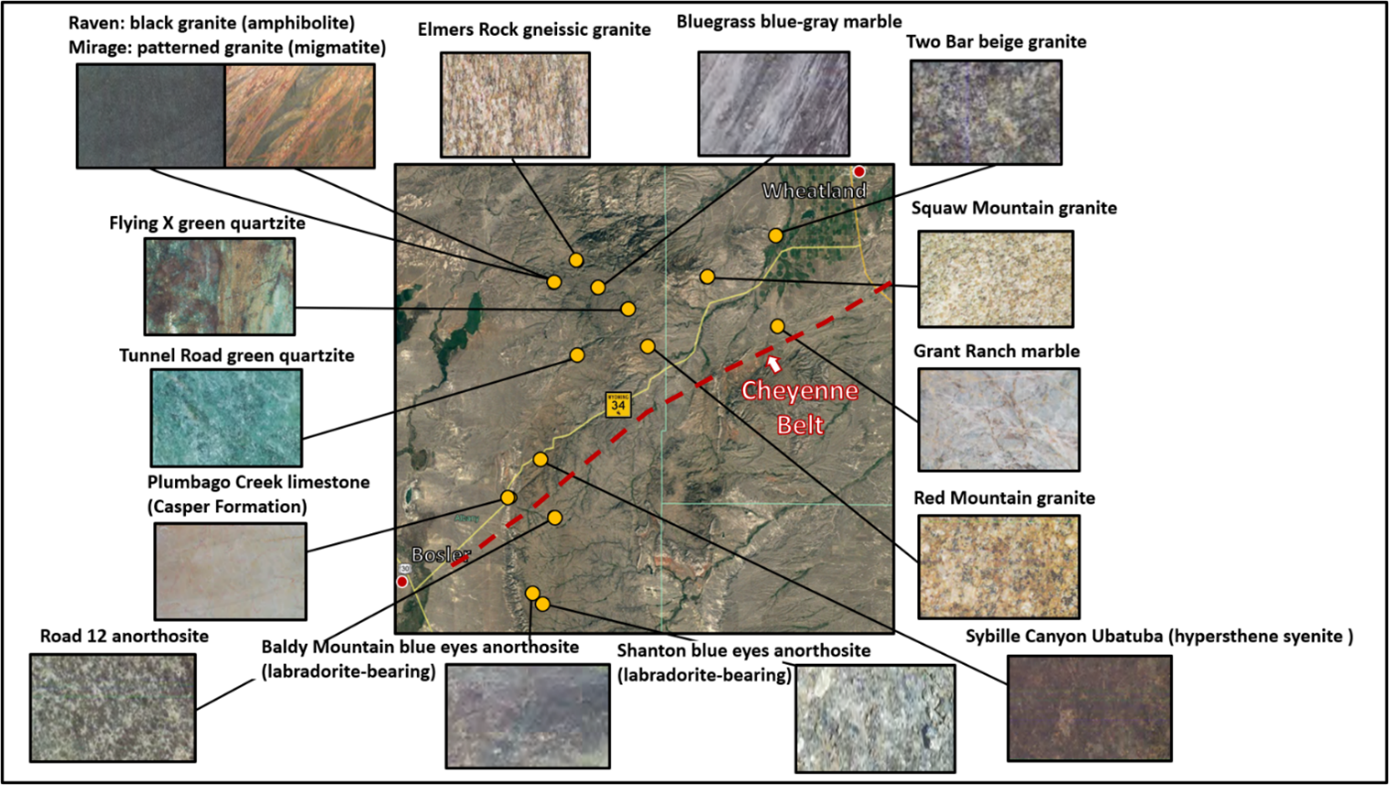
Selected bedrock quarry locations in the Sybille Canyon region, southern Laramie Range.
Image: Base: Google Earth; Stone photos: Harris, E., 2003, Decorative stones of southern Wyoming: Wyoming State Geological Survey Public Information Circular No. 42; https://www.wsgs.wyo.gov/products/wsgs-2003-pic-42.pdf
Image: Base: Google Earth; Stone photos: Harris, E., 2003, Decorative stones of southern Wyoming: Wyoming State Geological Survey Public Information Circular No. 42; https://www.wsgs.wyo.gov/products/wsgs-2003-pic-42.pdf

The material on this page is copyrighted