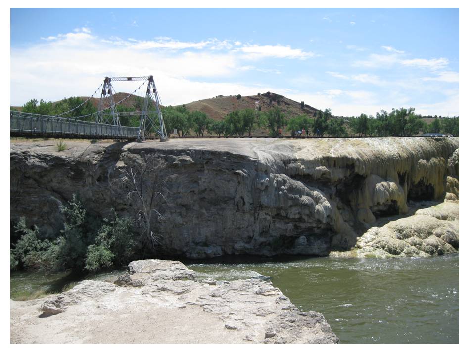
Travertine terrace and Bighorn River at Hot Springs State Park
Image by Mark Fisher
Image by Mark Fisher
Wow Factor (4 out of 5 stars):
Geologist Factor (4 out of 5 stars):
Attraction
Clouds of wet steam, warmth of the waters, allure of healing powers, the hidden source of the water, the smell of sulfur…. there is something enchanting and mystical about hot springs. Hot Springs State Park has it all from the fun of a water park to the scenic beauty of a hot spring flowing into a river.
History & Geology of Thermopolis Hot Springs
The place where Thermopolis is now located at the south end of the Bighorn Basin was an intersection for hunter gatherer clans. For thousands of years, Native Americans could find cooler summer dwellings, hunt abundant game and spend time relaxing in the therapeutic smoking waters. All this was possible because of the geology and geologic history that is present in Wyoming.
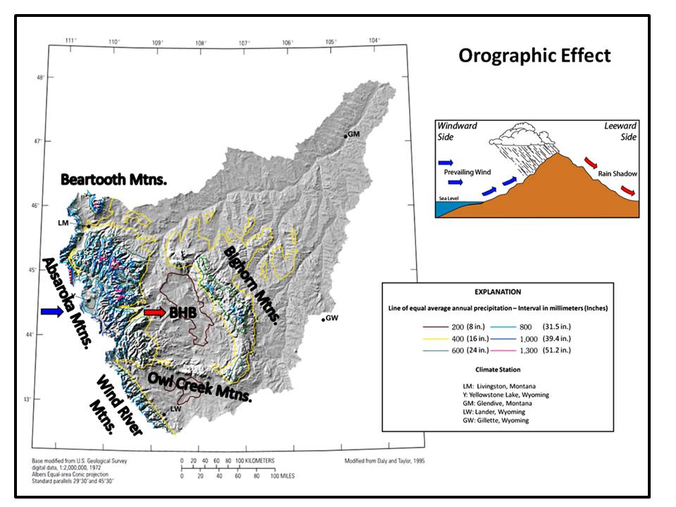
Indian rock art sites, shelters and animal kill sites are influenced by the lay of the land. The very presence of people, and many of the animals, is due to a land bridge formed across the Bering Strait during the last ice age between 11,000 and 17,000 years before present (BP). The Laramide mountain building event (70-55 million years ago) thrust up major Precambrian arches, exposing Paleozoic and Mesozoic rocks that are the source of the chert and quartzite used for tools. The orographic effect of these uplifts in conjunction with the latitude of the North American tectonic plate controlled the climate of the region. As humid westerly winds encounter the Rocky Mountains the air rises and precipitation occurs on the western and crest of the peaks. Dry air flows down the leeward side of the range into the basins. The Bighorn Basin receives an annual six to eight inches of precipitation per year.
Indian rock art sites, shelters and animal kill sites are influenced by the lay of the land. The very presence of people, and many of the animals, is due to a land bridge formed across the Bering Strait during the last ice age between 11,000 and 17,000 years before present (BP). The Laramide mountain building event (70-55 million years ago) thrust up major Precambrian arches, exposing Paleozoic and Mesozoic rocks that are the source of the chert and quartzite used for tools. The orographic effect of these uplifts in conjunction with the latitude of the North American tectonic plate controlled the climate of the region. As humid westerly winds encounter the Rocky Mountains the air rises and precipitation occurs on the western and crest of the peaks. Dry air flows down the leeward side of the range into the basins. The Bighorn Basin receives an annual six to eight inches of precipitation per year.
Changes in atmospheric conditions due to mountains (orogenic effect) surrounding the Bighorn Basin (BHB). Precipitation is up to six times greater on the windward side of the mountains.
Images: Left: After Zelt, R.B., Boughton, G., Miller, K.A., Mason, J.P. and Gianakos, L.M., 1999, Environmental Setting of the Yellowstone River Basin, Montana, North Dakota, and Wyoming: US Geological Survey, Water-Resources Investigation Report 98-4269, Fig. 4, p. 10, https://pubs.usgs.gov/wri/wri984269/wri984269.pdf ; Upper Right: https://c1.staticflickr.com/9/8249/8644087724_bcaca0e8ca_b.jpg
Images: Left: After Zelt, R.B., Boughton, G., Miller, K.A., Mason, J.P. and Gianakos, L.M., 1999, Environmental Setting of the Yellowstone River Basin, Montana, North Dakota, and Wyoming: US Geological Survey, Water-Resources Investigation Report 98-4269, Fig. 4, p. 10, https://pubs.usgs.gov/wri/wri984269/wri984269.pdf ; Upper Right: https://c1.staticflickr.com/9/8249/8644087724_bcaca0e8ca_b.jpg
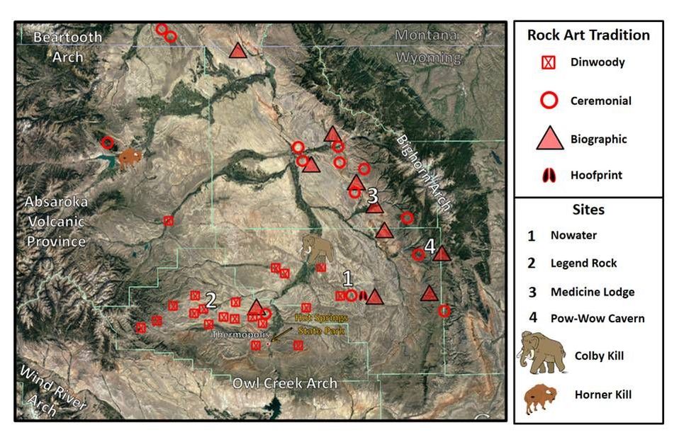
Erosion from superposed streams and glaciers carved out canyons where shelters and their rock art is found. The Tensleep Formation on the flanks of the mountains provided a canvass for petroglyphs and pictographs (e.g. Medicine Lodge and Pow-Wow Cavern). Mesozoic and Tertiary sandstones were used for the same purpose in the interior of the basin (Legend Rock: Frontier Sandstone; Oregon Basin and Nowater: Mesaverde Formation). Game kill sites used outcrop ledges, arroyos and sinkholes developed on the landscape (Colby Site: Mammoth, 11,200 BP; Horner Site: Bison, 7,880). Aquifers exposed in the mountains were the recharge sites for groundwater, which when heated by the earth’s temperature gradient could create hot springs and cover areas with travertine deposits.
Native American sites in the Bighorn Basin with respect to the Thermopolis Hot Springs. The locations are concentrated near the flanks of the mountains and the Absaroka Volcanic Province.
Image: Base: Google; Data: Keyser, J.D. and Poetschat, G., 2009, Crow Art in the Bighorn Basin: Petroglyphs at No Water, Wyoming: Oregon Archaeological Society Publication #20, Fig. 34, p. 52.
Image: Base: Google; Data: Keyser, J.D. and Poetschat, G., 2009, Crow Art in the Bighorn Basin: Petroglyphs at No Water, Wyoming: Oregon Archaeological Society Publication #20, Fig. 34, p. 52.
The Shoshone People have a legend about the discovery of the mineral hot springs located on the north side of the Owl Creek Mountains. A young couple were strolling along the Wind River in the canyon when a powerful gust of wind blew an eagle feather from her hair. Eagle feathers were a special gift, sacred to the Shoshone. The eagle was the messenger for the Great Spirit (Dama Upa). To lose a feather would be a great dishonor to the tribe. Their pursuit and recovery of the treasured item led them through the canyon to a magical place where the water bubbled and steamed from the ground. The Great Spirit’s messenger had led them to Bah Guewana, the smoking waters.
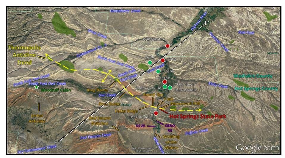
North aerial view of the Thermopolis area. Notation: Hot Springs State Park: red label, Towns: red dots, Abandoned towns: green dots, Thermopolis Anticline trend: yellow dash line, Topographic features: orange label, Twentieth Century oil fields: green highlight.
Image: Google Earth
Image: Google Earth
Geology of Thermopolis Hot Springs
Legendary US Geological Survey geologist Nelson Horatio Darton presented a model for the origin of the hot springs in his 1906 paper “The hot springs at Thermopolis, Wyoming” (Journal of Geology, v. 14, p. 194-200). Modern data has shown Darton’s interpretation to be mostly accurate. The elements of the hydrothermal system include: 1. Paleozoic aquifers are elevated and exposed to recharge from precipitation in the Owl Creek Mountains; 2. Groundwater is sealed in aquifers units by impermeable confining beds; 3. Flow is northward down the structural dip; 4. The water is heated by the geothermal gradient as depth increases; 5. Heated groundwater rises along faults and fractures associated with the Thermopolis Anticline trend; 6. Travertine is formed by precipitation of minerals from the spring water as it cools at the surface; 7. The deposition has occurred at different elevation levels as the bedrock eroded and the Bighorn River cut downward for thousands of years.
Diagrammatic model for the Thermopolis hydrothermal system. Darton’s seven elements are labelled.
Image: After Hinckley, B.S., Heasler, H.P., and King, J.K., 1982, The Thermopolis Hydrothermal System with an Analysis of Hot Springs State Park: WSGS Preliminary Report No. 20, Fig. 7, p. 22; https://www.osti.gov/scitech/servlets/purl/6053845/
Image: After Hinckley, B.S., Heasler, H.P., and King, J.K., 1982, The Thermopolis Hydrothermal System with an Analysis of Hot Springs State Park: WSGS Preliminary Report No. 20, Fig. 7, p. 22; https://www.osti.gov/scitech/servlets/purl/6053845/
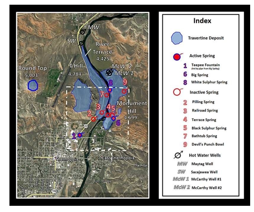
Aerial view of Hot Springs State Park. The one square mile boundary of the park is shown by the white dash-stipple line. Elevations on travertine deposits records movement of the hot springs as base level changed through time. Bighorn River elevation is 4,325’ indicating about a 700’ drop to date.
Image: Base: Google Earth; Data: After Hinckley, B.S., Heasler, H.P., and King, J.K., 1982, The Thermopolis Hydrothermal System with an Analysis of Hot Springs State Park: WSGS Preliminary Report No. 20, Fig. 2, p. 4; https://www.osti.gov/scitech/servlets/purl/6053845/
Image: Base: Google Earth; Data: After Hinckley, B.S., Heasler, H.P., and King, J.K., 1982, The Thermopolis Hydrothermal System with an Analysis of Hot Springs State Park: WSGS Preliminary Report No. 20, Fig. 2, p. 4; https://www.osti.gov/scitech/servlets/purl/6053845/
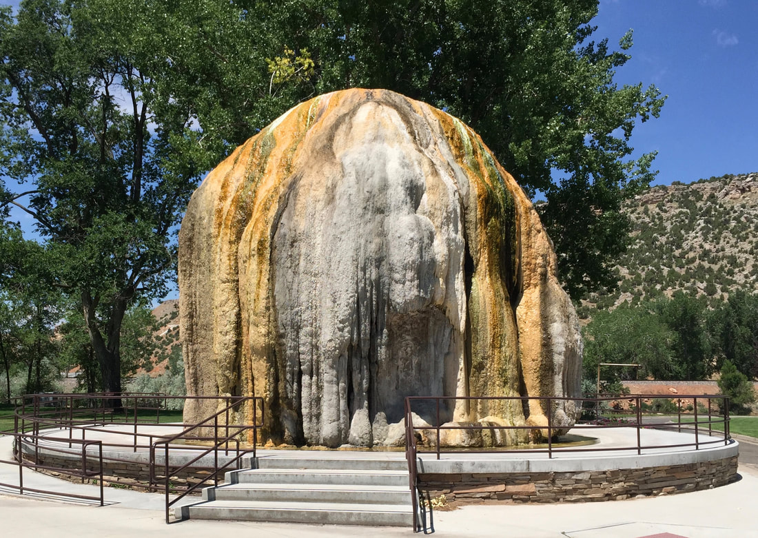
All the springs emerge in the Red Peak Member of the Chugwater Formation. This unit is a marginal aquifer and acts more as a regional confining bed for Paleozoic aquifers and hydrocarbon reservoirs. The water must rise from connections to the Paleozoic aquifers along the axis of the Thermopolis Anticline. Two springs remain active at the park, Big Spring and White Sulphur Spring. Big Spring is about 25 foot diameter and 130 feet deep. It currently flows 135 degree Fahrenheit water at 1,500 gallons per minute. It is the source of water for the Teepee Fountain, the state bath house and two commercial facilities. Early in the twentieth century the spring flowed at a rate of 13,000 gallons per minute, giving rise to the slogan on Monument Hill “World’s Largest Mineral Hot Spring.” The White Sulphur Springs flows 127 degree Fahrenheit water from a small opening at the base of a travertine ledge near the river at a rate of 200 gallons per minute. Teepee Spring is a man-made fountain built in 1906. Water is piped to the travertine cone in the spring and summer. Growth rate of the travertine is about one to two inches per year.
Active springs at Hot Springs State Park, Left: Big Spring, Right: White Sulphur Spring.
Images: Right: http://wondersofwyoming.com/files/2012/06/120615-Hot-Springs-State-Park-Big-Spring.jpg; Left: http://thermopoliswyoming.blogspot.com/2008/08/hot-springs-state-park-white-sulpher.html
Images: Right: http://wondersofwyoming.com/files/2012/06/120615-Hot-Springs-State-Park-Big-Spring.jpg; Left: http://thermopoliswyoming.blogspot.com/2008/08/hot-springs-state-park-white-sulpher.html
Teepee Fountain fed seasonally through pipes from Big Spring.
Image by Mark Fisher
Image by Mark Fisher
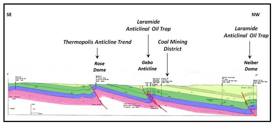
The Thermopolis Anticline extends for over 30 miles from Hamilton Dome (formerly called Cottonwood Anticline) on the west to Warm Springs Anticline to the east. This trend is part of the structures created by Laramide tectonics during the late Cretaceous and early Tertiary (70-55 Ma).
Structural cross section of faulted Laramide anticlines across the Thermopolis trend and the Gebo-Crosby coal district. Note that the fault (red line) on the south side of the Thermopolis Anticline trend (Rose Dome) has severed the continuity of the Paleozoic aquifers shown in blue and may be a barrier to water flow at this location.
Image: After Blackstone, D. L., Jr., 1985, Foreland Compressional Tectonics, Southern Bighorn Basin, Wyoming: Wyoming State Geological Survey Open File Report 85-3, Sheet 4, Fig. 10; http://www.wsgs.wyo.gov/products/wsgs-1985-ofr-03.pdf
Image: After Blackstone, D. L., Jr., 1985, Foreland Compressional Tectonics, Southern Bighorn Basin, Wyoming: Wyoming State Geological Survey Open File Report 85-3, Sheet 4, Fig. 10; http://www.wsgs.wyo.gov/products/wsgs-1985-ofr-03.pdf
The hot springs are currently located 30 feet above stream level on the axis of this structure. The complex includes about 16 travertine ledges, 45 cones, two active and six inactive springs, four sinkholes, and one man-made fountain.
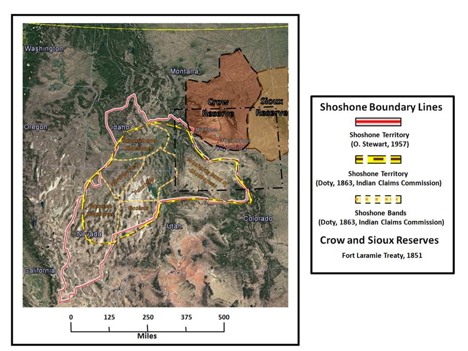
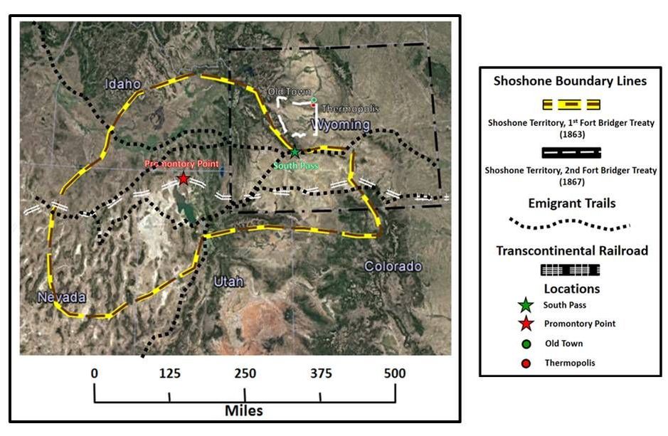
Mountain men were the first non-Indians to use the hot springs in the 1820s. They were an attraction to the area for local farmers and ranchers, but they belonged to the Shoshone. The first Fort Bridger Treaty of 1863 established the reservation and gave the tribal land legal status. The Wind River Basin corridor was left open but allowed for hunting by the tribes. The reservation system was meant to restrict Indian movement while providing corridors for transportation, communication and white settlement.
Mountain men were the first non-Indians to use the hot springs in the 1820s. They were an attraction to the area for local farmers and ranchers, but they belonged to the Shoshone. The first Fort Bridger Treaty of 1863 established the reservation and gave the tribal land legal status. The Wind River Basin corridor was left open but allowed for hunting by the tribes. The reservation system was meant to restrict Indian movement while providing corridors for transportation, communication and white settlement.
Shoshone territory after the First Fort Bridger Treaty of 1863. The reservation lands encompassed 44,672,000 acres, covering parts of Utah; Idaho; Montana; Colorado; and Wyoming. The boundaries contain most of their ancestral land and left an open corridor through the Wind River Basin in which hunting was allowed. Old Town would be located outside the Shoshone reservation by this treaty, but on land reserved for the Crow by the Fort Laramie Treaty of 1851.
Image: Base; Google Earth; Data: https://collections.lib.utah.edu/details?id=358825 and http://www.rootsweb.ancestry.com/~mtyellow/history/npr-beginnings_files/image008.jpg
Image: Base; Google Earth; Data: https://collections.lib.utah.edu/details?id=358825 and http://www.rootsweb.ancestry.com/~mtyellow/history/npr-beginnings_files/image008.jpg
The Second Fort Bridger Treaty of 1867 adjusted the boundaries of the reservation northward in favor of the Shoshone over other tribes. The northern boundary now followed the South Fork of Owl Creek. The hot springs were now on reservation land. However the reservation acreage was cut from about 45 million acres to 2.8 million acres. There was also a requirement for the tribe to transition to a farm culture. The Crow moved to a Montana reservation in 1868, ceding their claim to the Bighorn Basin. Although surrounded by Indian lands, the basin was now open for white settlement. The first permanent dwelling in the basin was J.D. Woodruff’s cabin along Owl Creek, built in 1871.
Shoshone territory after the Second Fort Bridger Treaty of 1867. Reservation boundaries: 1863: yellow and brown dash line; 1867: white dashed line. The reservation lands encompassed 2,774,400 acres, covering most of the western Wind River Basin and the southwestern most part of the Bighorn Basin. Old Town was established outside the border at the northeast corner of the reservation in the 1880s.The Crow sold 30 million acres of their land and moved onto a reservation in Montana in 1968. The path of the emigrant trails (black dotted lines, 1846-1869) and South Pass (green star) across the 1863 Fort Bridger Treaty reservation boundaries are shown. The path of the future transcontinental railroad (double white dash lines) completed in May 1869 at Promontory Point, Utah Territory (red star) was a strong incentive to reduce the reservation territory. Old Town: green dot; Thermopolis: red dot.
Image: Base: Google Earth; Data: http://wyomingplaces.pbworks.com/f/1299281521/1879CGLOMapWY.jpg
Image: Base: Google Earth; Data: http://wyomingplaces.pbworks.com/f/1299281521/1879CGLOMapWY.jpg
Darton’s report was written after the 1905 cession of tribal land along the northern border that was to be opened for settlement in 1906. The Hot Springs area had been ceded in 1896 with the movement of the Old Town residents to the new location in 1897. He recognized a key point about Thermopolis in his report.
“It owes its existence mainly, if not entirely, to a series of thermal springs, one of large volume, flowing out of the ‘Red Beds’ on the bank of the River.”
(Darton, N.H., 1906, Geology of the Owl Creek Mountains, with Notes on Resources of Adjoining Regions in the Ceded Portion of the Shoshone Indian Reservation, Wyoming: U.S. Senate Document No. 219, 59th Congress, 1st Session, p. 38. https://archive.org/stream/geologyowlcreek00sgoog#page/n4/mode/2up)
The hot springs were the main attraction to the area for white settlers and tourists. But the town had to overcome unflattering first impressions, like the comment by a 1908 Missouri immigrant speaking to his uncle:
“I just want to know – what did you do that you had to come here to hide. No one would live here if they didn’t have to!”
(Wyoming Historical Society website project at http://www.wyohistory.org/encyclopedia/hot-springs-county-wyoming)
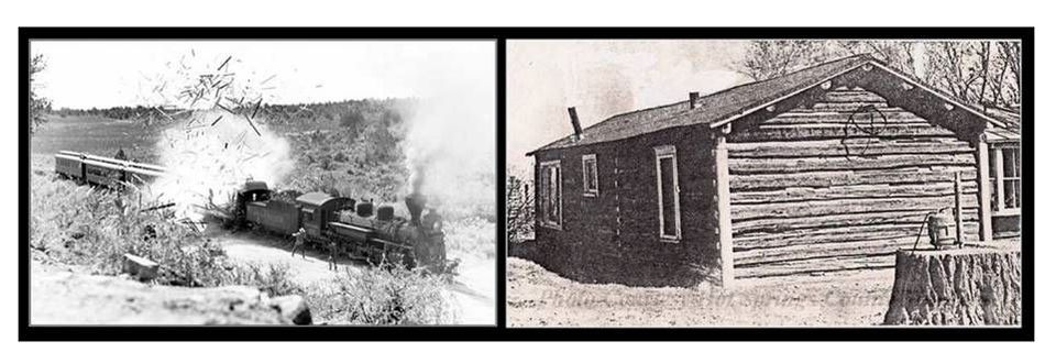
The Anderson brothers came to raise beans at the confluence of Owl Creek and Bighorn River in 1870. They ended up establishing Andersonville and the Anderson Hog Ranch. This saloon had the basin’s first piano, several prostitutes and a clientele that included on-the-run outlaws. The 1969 movie Butch Cassidy and the Sundance Kid includes a scene of the 1899 Wilcox Train Robbery where they blow up the mail car. This team of outlaws hid out at the “Hog House” to celebrate their $60,000 heist. Andersonville was an isolated place, free from the law. Before Big Horn County was organized in 1897 the law for those on the east side of the Bighorn River was in Buffalo, Johnson County. Lander, Fremont County, serviced those on the west side of the river. Although the situation improved, the area was largely lawless. The Bighorn Basin had about 4,300 people and only one sheriff at this time. The only way to get to Andersonville was across mountain ranges to the east and south, or a 100 mile ride from Montana. The Bighorn Basin was still a frontier and the geology had created a lot of space to hide out.
Left: Wilcox Train Robbery dynamite scene from Butch Cassidy and the Sundance Kid movie, 1969.
Right: Anderson’s Hog Ranch, circa 1890.
Image: Left: Colorado Central Magazine, 2015, A.M. Payne, 1967, photo; http://cozine.com/wp/wp-content/uploads/2015/03/CC-Butch.jpg;
Right: Hot Springs County Museum & Cultural Center, 2011, Andersonville Saloon digital Image; http://hschistory.pastperfectonline.com/media/B6D8624D-67ED-40ED-847F-744809258390
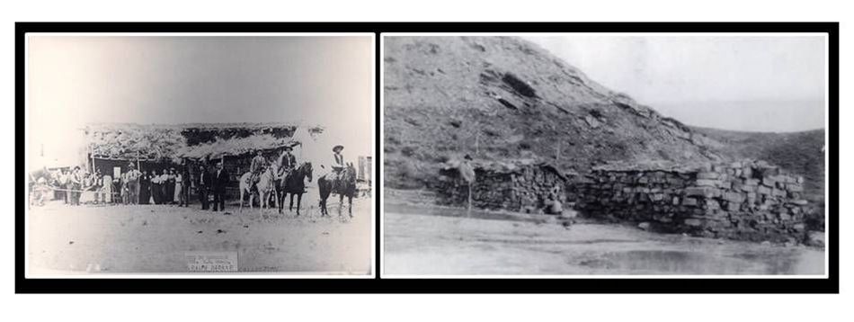
Old Town Thermopolis was established in 1880 across the river from Andersonville. They catered to local ranchers and homesteaders in the area. Large groups of settlers did not begin to appear until the 1890s. Old Town businesses supplied better goods, and accommodations, to the squatters, trespassers and “frontier entrepreneurs” on Shoshone reservation land near the hot springs.
Left: Hotel de Sagebrush accommodations on reservation land, 1896.
Right: Early stone-walled bath-houses cut into travertine from 1899-1902.
Image: Left: Hot Springs County Museum http://hschistory.org/gallery/displayimage.php?pid=133&fullsize=1; Right: Service, A. and Milek, D., 2005, Hot Springs County (WY) (Images of America), p. 12.
Right: Early stone-walled bath-houses cut into travertine from 1899-1902.
Image: Left: Hot Springs County Museum http://hschistory.org/gallery/displayimage.php?pid=133&fullsize=1; Right: Service, A. and Milek, D., 2005, Hot Springs County (WY) (Images of America), p. 12.
The townspeople believed the hot springs were the key to their future development and began to pressure Chief Washakie to sell the land in the early 1890s. In 1895, when the post office moved from Torrey (2 mile west up Owl Creek) to their town, they renamed the community Thermopolis in recognition of the importance the springs held for them. The town promptly moved to their present location after the 1896 Cession Agreement with the tribe was ratified by Congress. Balneology (the therapeutic use of baths, particularly hot springs) was a popular branch of medicine of the late 19th and early 20th century. Medical treatment centers sprang up around the hot springs. Today the use of spas is a popular recreational activity (spa is a Latin abbreviation for the phrase ”Salud Per Aqua”: health through water). “Thermopolians” were eager for all to “take the waters” in their new town, a sentiment that has not diminished. When the county was established in 1911, it was named Hot Springs after the smoking waters.
Left: Old Town Thermopolis, 1895.
Right: New Town Thermopolis, 1905.
Image: Left: Unknown Photographer, 1895, Photo: Wyoming State Archives; http://wyomingplaces.pbworks.com/w/page/12715852/Old%20Town; Right: Stimson, J.E, 1909, Photo: Wyoming State Archives; http://www.wyohistory.org/sites/default/files/styles/large/public/fuller1.jpg?itok=1h5cEcnD
Thermopolis Hot Springs Water Flow Rates
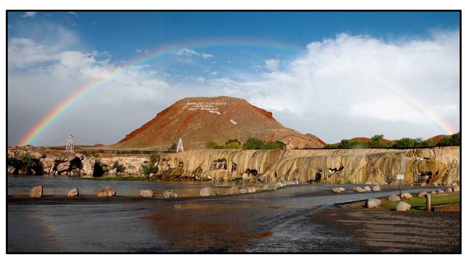
Monument Hill, Hot Springs State Park, Thermopolis, Wyoming
Image by: http://thermopolis.com/attractions/hot-springs-state-park/photo-gallery/ after Court, M., mywyomingphotography
Image by: http://thermopolis.com/attractions/hot-springs-state-park/photo-gallery/ after Court, M., mywyomingphotography
The local residents have a major concern about whether the hot springs flow has decreased over time. If the flow has decreased, why has it decreased? Can anything be done to increase the flow?
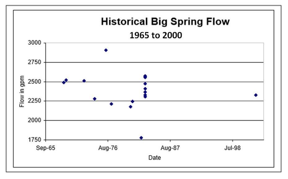
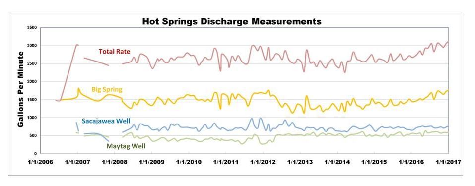
Reported flows from the Big Spring have varied significantly, especially in the first half of the 1900’s. Some of the flow estimates were so large (12,500 gpm), that it led to the claim of “World’s Largest Mineral Hot Spring”, which was emblazoned on Monument Hill. These high flow rates are questionable. The Wyoming State Geologist in 1926 measured the flow at 2,778 gpm. Similar rates of 2,200 to 2,800 gpm were measured from the 1960’s to 2000 (see first chart below), which suggests no material decrease in Big Spring flow. Starting in 2006, the State Engineer’s Office collected monthly flow data on the Big Spring and two nearby uncontrolled artesian thermal wells (see second chart below). This recent data suggests a fairly constant flow rate from 2006 to 2017 of about 1,500 gpm. Assuming all these rates are somewhat close to reality, there has been a significant drop of about 1,000 gpm between the last half of 20th century and the first part of the 21st century.
Reported flows from the Big Spring have varied significantly, especially in the first half of the 1900’s. Some of the flow estimates were so large (12,500 gpm), that it led to the claim of “World’s Largest Mineral Hot Spring”, which was emblazoned on Monument Hill. These high flow rates are questionable. The Wyoming State Geologist in 1926 measured the flow at 2,778 gpm. Similar rates of 2,200 to 2,800 gpm were measured from the 1960’s to 2000 (see first chart below), which suggests no material decrease in Big Spring flow. Starting in 2006, the State Engineer’s Office collected monthly flow data on the Big Spring and two nearby uncontrolled artesian thermal wells (see second chart below). This recent data suggests a fairly constant flow rate from 2006 to 2017 of about 1,500 gpm. Assuming all these rates are somewhat close to reality, there has been a significant drop of about 1,000 gpm between the last half of 20th century and the first part of the 21st century.
Big Spring flow rates in gallons per minute
Chart from Hot Springs State Park Master Plan 2003 Level 1, prepared by Lidstone and Associates for the Wyoming Water Development Commission, Figure originally from Jarvis (1986)
Chart from Hot Springs State Park Master Plan 2003 Level 1, prepared by Lidstone and Associates for the Wyoming Water Development Commission, Figure originally from Jarvis (1986)
Flow rates in gallons per minute of Big Spring (yellow), Sacajawea well (blue), Maytag well (gray), and total of two wells plus Big Spring (red)
Chart from Wyoming State Engineer’s Office
Chart from Wyoming State Engineer’s Office
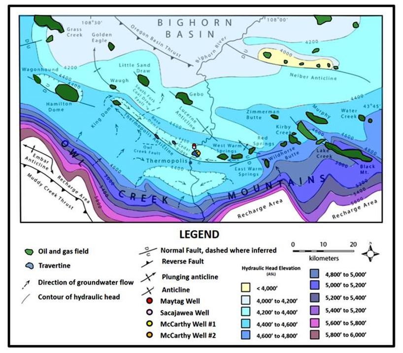
Thermal waters occur along the Thermopolis Anticline (fold) in aquifers of the Upper Paleozoic Phosphoria, Tensleep and Madison Formations. Similar water chemistry, water temperature and hydraulic head (elevation to which water will rise due to pressure in an aquifer) indicate the waters are intermixed and connected along faults and fractures on the anticline. Water movement along the anticline is believed to be from northwest to southeast.
The decreased flows at the Big Spring could possibly be due to a restriction caused by natural cementation of the subsurface plumbing. Another possibility is hot water could be bypassing the historic springs and discharging directly into the bottom of the river. Several springs have been observed in the river and along the edge of the river from the swinging bridge downstream toward the White Sulphur Spring. Another explanation for lower flows is a decrease in pressure or hydraulic head in the aquifer due to a combination of prolong drought, oil and water production from nearby oil fields in the southern Bighorn Basin, and uncontrolled hot water flows from artesian wells less than two miles from the Big Spring. Aquifer pressure that supports the flow at the Big Spring is a balance of replenishment and outflows. Replenishment includes natural recharge into the Paleozoic outcrops in the Owl Creek Mountains and Wind River Canyon, water injection at the oil fields, and possibly the leaky reservoir at Anchor Dam. Outflows include the springs, oil & water production at oil fields, water flows from artesian thermal wells, and finally regional subsurface flow to the north-northeast.
The decreased flows at the Big Spring could possibly be due to a restriction caused by natural cementation of the subsurface plumbing. Another possibility is hot water could be bypassing the historic springs and discharging directly into the bottom of the river. Several springs have been observed in the river and along the edge of the river from the swinging bridge downstream toward the White Sulphur Spring. Another explanation for lower flows is a decrease in pressure or hydraulic head in the aquifer due to a combination of prolong drought, oil and water production from nearby oil fields in the southern Bighorn Basin, and uncontrolled hot water flows from artesian wells less than two miles from the Big Spring. Aquifer pressure that supports the flow at the Big Spring is a balance of replenishment and outflows. Replenishment includes natural recharge into the Paleozoic outcrops in the Owl Creek Mountains and Wind River Canyon, water injection at the oil fields, and possibly the leaky reservoir at Anchor Dam. Outflows include the springs, oil & water production at oil fields, water flows from artesian thermal wells, and finally regional subsurface flow to the north-northeast.
Water flow rates in gallons per minute. Oil field water production does not reflect that much of this water is injected back into the oil fields to maintain reservoir pressure. The net water production rate from Gebo and Hamilton Dome Oil Fields is less than shown in this chart because of re-injection.
Geol Survey WY data from Hinckley, B.S., Heasler, H.P., and King, J.K., 1982, The Thermopolis Hydrothermal System with an Analysis of Hot Springs State Park, The Geological Survey of Wyoming Preliminary Report No. 20
SEO data from State Engineer’s Office, WOGCC data from Wyoming Oil and Gas Conservation Commission
Left: Uncontrolled artesian Sacajawea well at Fountain of Youth Hot Spring and RV Park, average flow during 2016 of 733 gallons per minute
Right: Uncontrolled artesian Maytag well located just north of Fountain of Youth Hot Spring and RV Park, average flow during 2016 of 577 gallons per minute
Images by Mark Fisher
Right: Uncontrolled artesian Maytag well located just north of Fountain of Youth Hot Spring and RV Park, average flow during 2016 of 577 gallons per minute
Images by Mark Fisher
The artesian thermal wells together, flow about as much water as the Big Spring. Some of the water from these wells is used beneficially, but the majority flows unused into the Bighorn River. If aquifer pressure were to decline, the Big Spring will dry up before the artesian wells stop flowing because the surface elevations of the artesian wells are about 50 feet lower than the Big Spring. Long term, say 50 to 100 years in the future, the oil fields will eventually be depleted and plugged out. At that point, the aquifer will no longer lose pressure due to oil field production of water and oil. One solution to increase the flow at the Big Spring is to stop the uncontrolled flow of water at the artesian wells. Local oil man Dan Wychgram proposed a method for bringing these wells under control. He created a non-profit corporation called “Save the Big Spring” to fund this effort, but was unsuccessful in finding financial support. A second solution to restore flow would be to install pumps in the pool where the Big Spring emanates. The drawback is this detracts from the esthetics of a natural spring, and it would lower the water level in the pool an unknown amount. A pump test of the spring and monitoring of the offsetting artesian well flow rates could prove the existence and amount of interference by the artesian wells.
It is the hope of the citizens of Thermopolis that the “smoking waters” have a future. These citizens, the State of Wyoming, and nature control the fate of Bah Guewana in these ancient gathering grounds.
It is the hope of the citizens of Thermopolis that the “smoking waters” have a future. These citizens, the State of Wyoming, and nature control the fate of Bah Guewana in these ancient gathering grounds.
Potentiometric surface for the Phosphoria-Tensleep aquifer. Contours show elevations of equal hydraulic head. Arrows show ground water flow direction. Note flow along Thermopolis Anticline from northwest to southeast to the Big Spring. The fault paralleling the Thermopolis Anticline on the south side has a couple thousand feet of dip displacement and may be a barrier to flow. If that is the case, water entering the outcrops on the Owl Creek Mountains probably flows around the northwest end of the fault near King Dome or crosses the fault in places where it has less displacement and there is aquifer continuity.
Image: After John P. Kaszuba, J.P., Sims, K.W.W., Pluda, A.R., 2014, Aqueous geochemistry of the Thermopolis hydrothermal system, southern Bighorn Basin, Wyoming, U.S.A.: Rocky Mountain Geology, v. 49, no. 1, Fig. 2, p. 3; http://geofaculty.uwyo.edu/jkaszub1/PDFs/Kaszuba%20et%20al.,%202014.pdf
Image: After John P. Kaszuba, J.P., Sims, K.W.W., Pluda, A.R., 2014, Aqueous geochemistry of the Thermopolis hydrothermal system, southern Bighorn Basin, Wyoming, U.S.A.: Rocky Mountain Geology, v. 49, no. 1, Fig. 2, p. 3; http://geofaculty.uwyo.edu/jkaszub1/PDFs/Kaszuba%20et%20al.,%202014.pdf
Coal and Oil Near Thermopolis
Coal was first discovered in the area about the same time as the founding of Old Town. Locals mined the coal for their personal use and to sell to their neighbors. The first commercial mining was the Jones Mine that began small-scale operation in 1898. Cassius A. Fisher, US Geological Survey geologist, reported on the mining potential of the Thermopolis area that was to become the Gebo-Crosby Coal District in 1906. The district covered about 34 square miles and was the most worked in the Bighorn Basin (produced 90% of Bighorn Basin coal). Fisher also noted that development at the hot springs included two sanitariums and a large plunge:
“… the place is rapidly becoming a popular health resort for people of northwestern Wyoming.”
Fisher, C.A., 1906, Geology and Water Resources of the Bighorn Basin, Wyoming: U.S. Geological Survey Professional Paper No. 53, p. 62.
Coal is formed from woody plant material (humus) that collects at the bottom of a swamp. As the swamp is buried beneath younger sediments it is subjected to pressure and temperature changes that convert the mass into coal. It generally takes 5,000 to 8,000 feet of burial to reach a temperature of 150 degrees Fahrenheit to convert humus to sub-bituminous grade coal.
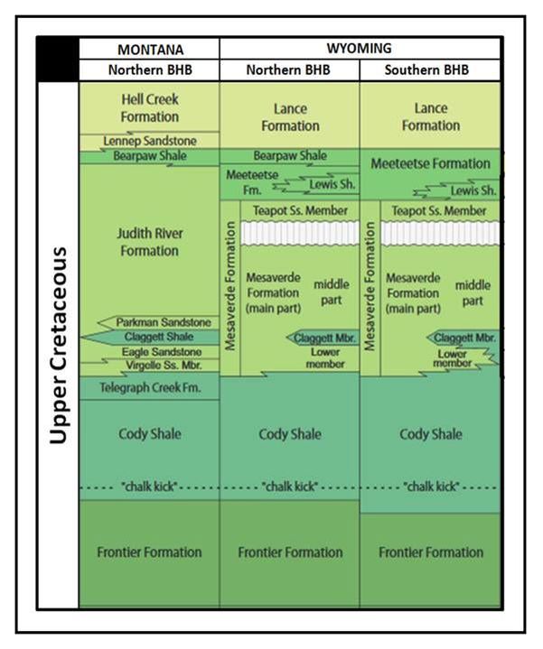
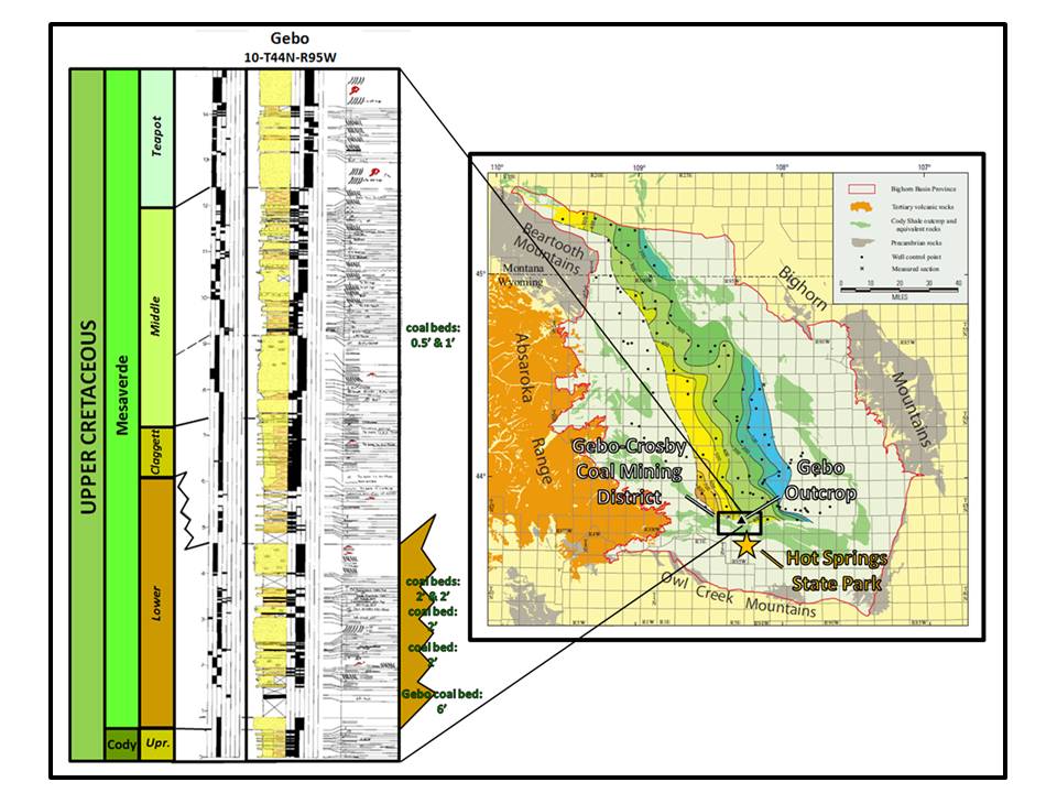
The coal found in the Gebo-Crosby mining district is mostly sub-bituminous rank and tends to be lower in sulfur than other coal grades. It has a fixed carbon content of 47 to 49% and contains 8,000 to 13,000 BTU heat value. The coal beds are developed in the Middle Cretaceous Mesaverde Formation. The Mesaverde can be subdivided into four units: upper, middle, Claggett, and lower members. The lower member is an eastward building deltaic complex that consists of sand, silt, shale and coal beds. The Claggett member is a tongue of the Cody Shale that separates the middle and lower members. The middle member is a mixed clastic sequence of sandstones, siltstones, mudstones and coals deposited as the Western Interior Seaway retreated to the east. An unconformity separates the upper and middle units. The uppermost member is the Teapot Sandstone which is a nonmarine unit throughout most of the basin.
Bighorn Basin Upper Cretaceous stratigraphic chart. The coal beds are located in the middle and lower part of the Mesaverde Formation.
Image: Finn, T.M., Kirschbaum, M.A., Roberts, S.B., Condon, S.M., Roberts, L.N.R., and Johnson, R.C., 2010, Chapter 3: Cretaceous–Tertiary Composite Total Petroleum System (503402), Bighorn Basin, Wyoming and Montana: USGS DDS 69-V, Fig. 7, p. 10.
Image: Finn, T.M., Kirschbaum, M.A., Roberts, S.B., Condon, S.M., Roberts, L.N.R., and Johnson, R.C., 2010, Chapter 3: Cretaceous–Tertiary Composite Total Petroleum System (503402), Bighorn Basin, Wyoming and Montana: USGS DDS 69-V, Fig. 7, p. 10.
Left: Mesaverde Formation outcrop description from Gebo (12 miles north of Hot Springs State Park). Coal beds are only developed in the middle and lower members of the Mesaverde.
Right: Thickness Map of the Lower Member of the Mesaverde Formation where the majority of the coal beds are developed. The contour interval is 100 feet. Red dotted line marks the western limit of Claggett Member deposition. The blue dashed line marks the eastern limit of the Claggett Shale tongue. East of this line is the Mesaverde overlies the Cody Formation. The line also marks the approximate eastern limit of the Lower Member of the Mesaverde Formation. Location of Gebo-Crosby Coal Mining District is shown by black rectangle. Star marks location of the Thermopolis hot springs.
Image: Left: After Johnson, R.C., Keefer, W. R. Keighin, C. W. and Finn, T. M., 1998, Detailed Outcrop Studies of the Upper Part of the Upper Cretaceous Cody Shale and the Upper Cretaceous Mesaverde, Meeteetse, and Lance Formations, Bighorn Basin, Wyoming: WGS Guidebook, Plate 1.
Right: After Finn, T.M., Kirschbaum, M.A., Roberts, S.B., Condon, S.M., Roberts, L.N.R., and Johnson, R.C., 2010, Chapter 3: Cretaceous–Tertiary Composite Total Petroleum System (503402), Bighorn Basin, Wyoming and Montana: USGS DDS 69-V, Fig. 13, p. 18.
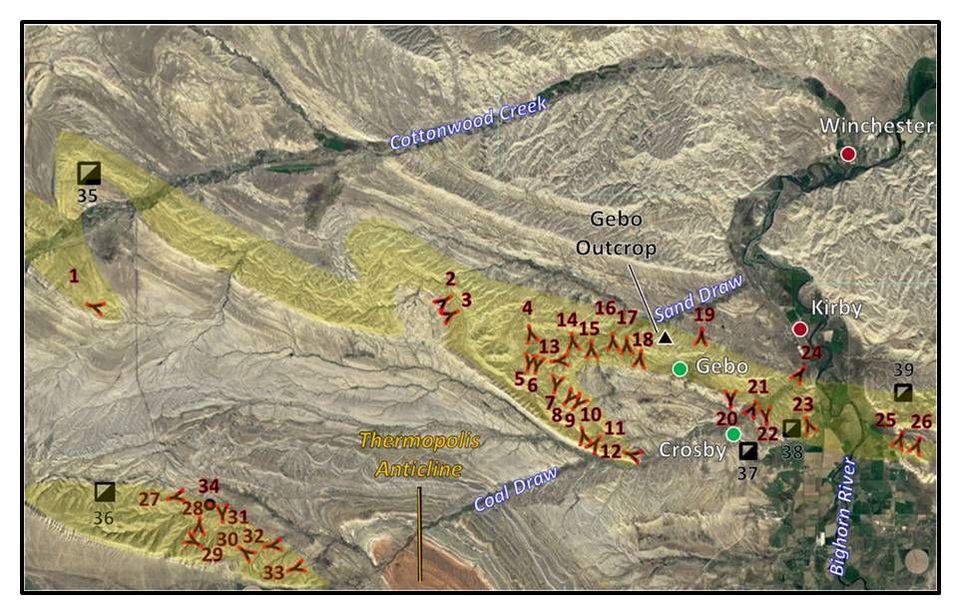
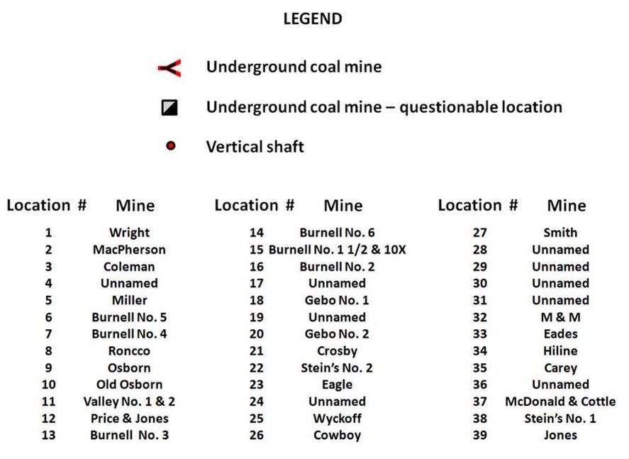
Aerial view of Gebo-Crosby Coal Mining District. Location of outcrop description from previous image is shown. Towns shown with red dots. Abandoned towns shown with green dots. The Mesaverde Formation outcrop is highlighted in yellow.
Image: Base: Google Earth; Data: Luhr, S.C., and Jones, R.W., 1985, Extent of coal-bearing rocks and locations of coal mines in the Bighorn Basin, Montana and Wyoming: Geological Survey of Wyoming [Wyoming State Geological Survey] Open File Report 85-4, 1 sheet; http://www.wsgs.wyo.gov/products/wsgs-1985-ofr-04.pdf
Image: Base: Google Earth; Data: Luhr, S.C., and Jones, R.W., 1985, Extent of coal-bearing rocks and locations of coal mines in the Bighorn Basin, Montana and Wyoming: Geological Survey of Wyoming [Wyoming State Geological Survey] Open File Report 85-4, 1 sheet; http://www.wsgs.wyo.gov/products/wsgs-1985-ofr-04.pdf
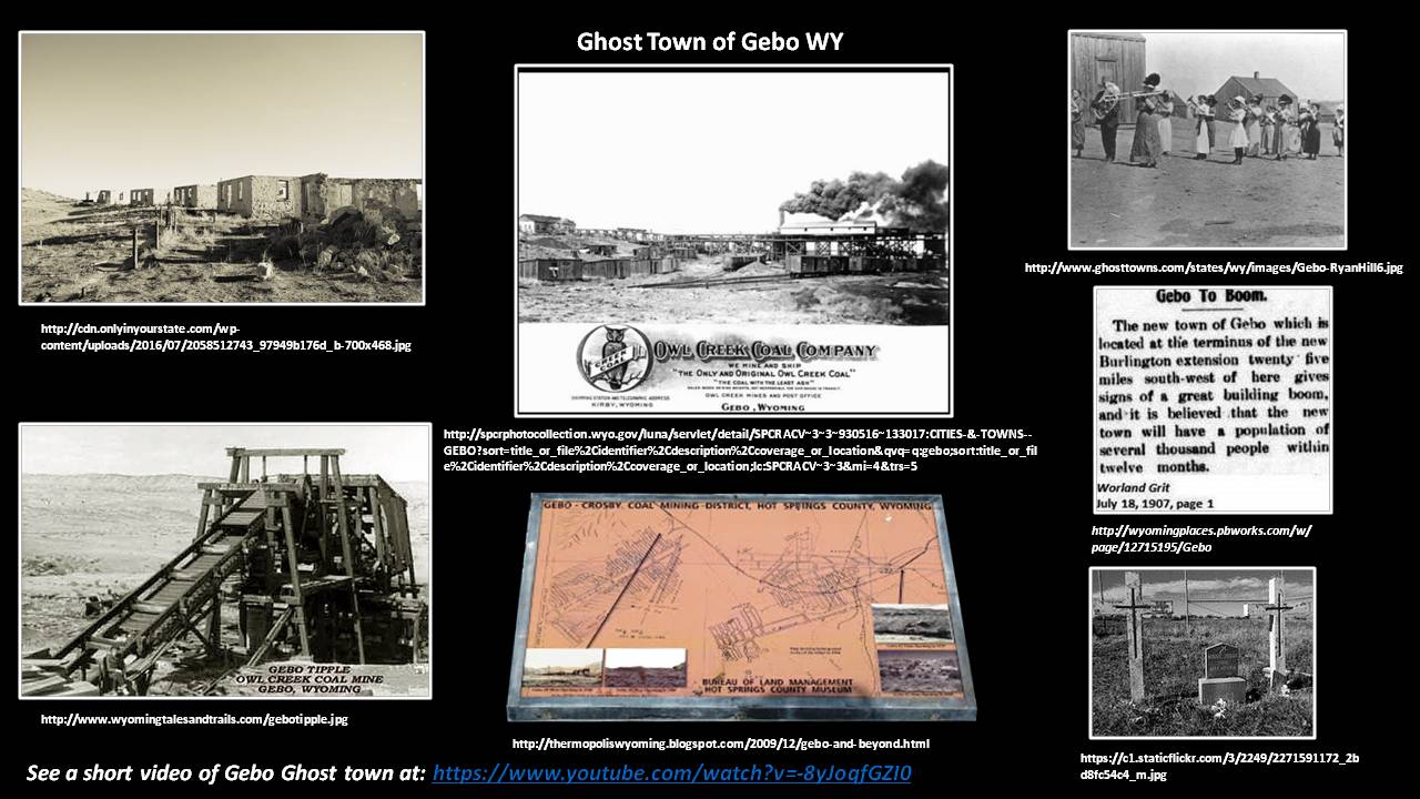
In 1906, Sam Gebo founded the Owl Creek Mining Company and began operations at the Gebo No. 1 Mine in 1907. Coal mining on United States public land was controlled by the General Mining Act of 1872. People could freely explore public lands, stake a 20 acre mineral claim and hold it by spending $100 per year on the land. They could purchase (patent) their claim for $2.50 per acre. Some dishonest companies put up front men (entrymen) to falsely file claims and then sell them back to the company. Vast tracts of land could be amassed for mining and land speculation. Sam Gebo, and his partners, were engaged in this type of scheme. They even used cooperative dead people as entrymen. President Teddy Roosevelt became suspicious of all their filings made on the same day and had the Land Office begin a fraud investigation. The Owl Creek Mining Company’s fraudulent patents on public land were revoked in 1912. Sam ran off to Guatemala while the miners were left with no work. Through the appeal of the local mine union leader and Wyoming Senator Francis Warren, Congress passed a joint resolution, signed by President Taft that created a novel solution. The government would lease the lands back to the company for a period of time for a royalty payment on produced coal. The Gebo Mine was the first mineral operation in the United States to use a leasing system. This experiment led to the 1920 Mineral Leasing Act which gave access to public land on a rental, rather than an ownership basis. Gebo was active from 1907 to 1938. The Crosby (Kirby) Mines closed earlier in 1933 after a fire in the Crosby No. 1 mine. The railroads conversion to diesel fuel and the nation’s change from coal to oil as a source for power foreordained the end for the mines. The company ghost towns of Gebo and Crosby are abandoned, but the leasing system they inspired remains.
This area that began as a sacred, therapeutic hot spring for Native Americans, transformed into a white settlement, tourist/medical resort, and then evolved into a hub for agriculture and energy production. At each stage of development the area’s geology played a critical role. It is intriguing that the Thermopolis area encompasses the energy resources of the three stages of the nation’s energy development. First came hunter gatherers and Native Americans who relied on wood and sagebrush found in the mountains and along streams to make fire for heat and light. It has been estimated that seventy percent of the country’s energy needs were supplied by wood as late as 1870 (O'Conner, 2010). This stage was followed by the coal period that powered the steam engines of the industrial revolution.
Coal-fueled energy first supplanted wood in the United States in 1884 (O'Conner, 2010). The first steam engines were constructed to remove water from coal mines. Canals and trains were first used to transport coal to markets. By 1900, seventy percent of the county’s energy came from coal (O'Conner, 2010). Most of the coal from the Gebo-Crosby district was used by the railroads.
Oil was first used to replace whale oil for illumination, but was soon used as a power source. It replaced coal’s energy position by 1946 (O'Conner, 2010). By 1950, seventy percent of the nation’s energy was produced from hydrocarbons (O'Conner, 2010). The vast oil reserves in the Bighorn Basin provided fuel that powered the internal combustion engines of the twentieth century. The economic importance of the petroleum industry, surpasses that of those who come to visit the smoking waters of the hot springs and provides 65-75 percent of Hot Springs County’s tax base. The hydrocarbons were generated from Paleozoic and Cretaceous source rocks. Oil generation occurs when burial depths are between 7,500 to 15,000 feet. Deeper than this and oil begins to crack to gas. The Paleozoic source began converting 250 million year old Permian organic matter to oil, about 160 million years ago. The Cretaceous organic-rich shales were deposited in the basin between 110 and 65 million years ago in the Western Interior Seaway. They began to convert to oil about 60 million years ago. Both oils accumulated in reservoirs within structural traps created by Laramide compressional tectonics. Today coal is used in about 30 percent of the nation’s electrical generating plants. In the twenty first century, natural gas continues to replace coal for the production of electricity due to economics and environmental concerns.
“Civilization exists by geologic consent, subject to change without notice.”
Will Durant (1885-1981)
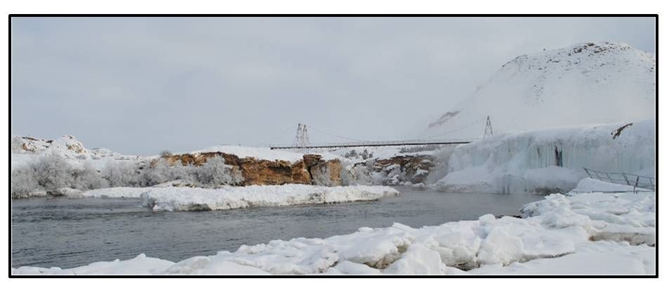
The smoking Waters in winter.
Image: Hot Springs State Park Report of Recommendations: Prepared by the Hot Springs State Park Master Plan Steering Committee, February 2015; http://wyoparks.state.wy.us/pdf/Planning/SteeringCommiteeReports/REPORTRECOMMENDATIONSHotSprings.pdf
Image: Hot Springs State Park Report of Recommendations: Prepared by the Hot Springs State Park Master Plan Steering Committee, February 2015; http://wyoparks.state.wy.us/pdf/Planning/SteeringCommiteeReports/REPORTRECOMMENDATIONSHotSprings.pdf
Things To Do In Thermopolis Area
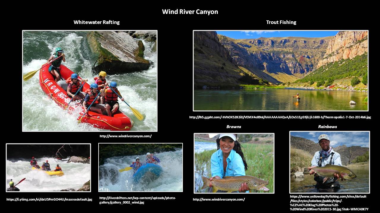
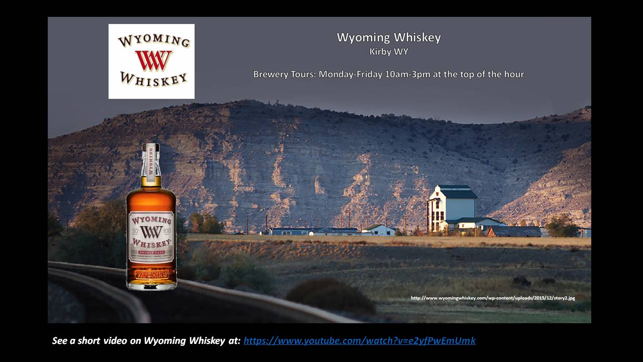
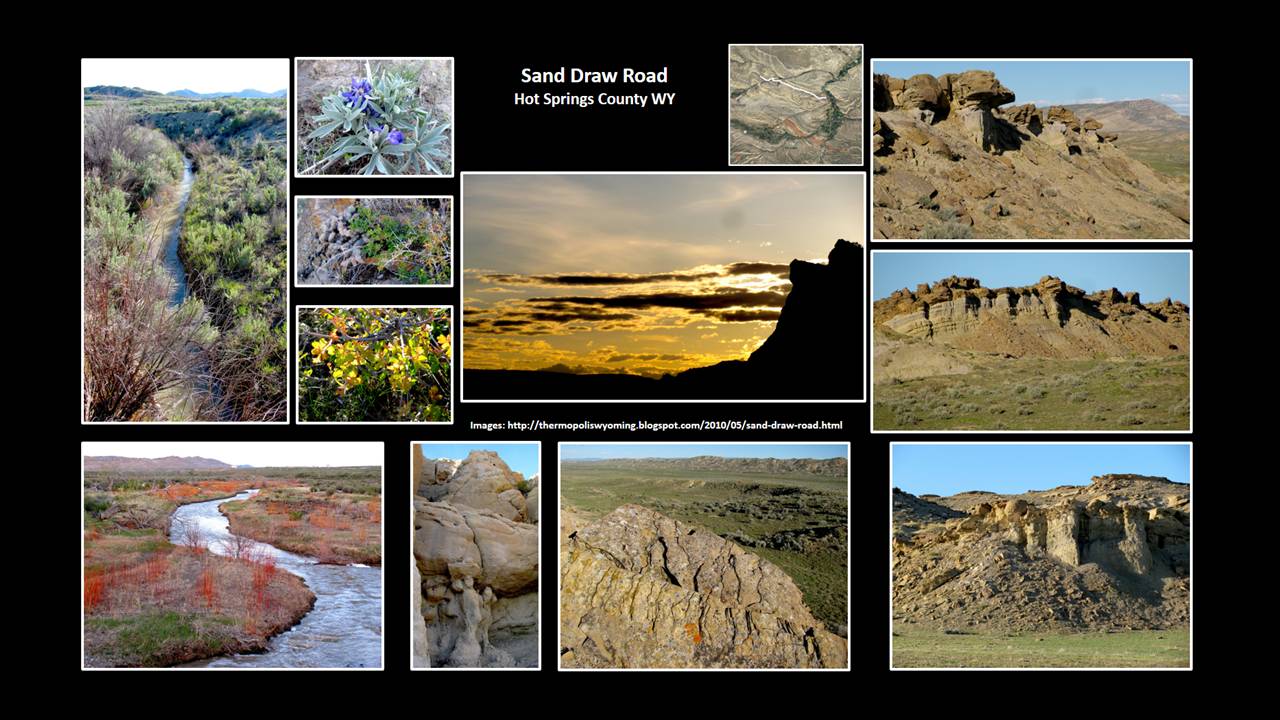
Our recommendations for fun things to do include drive and look at the geology in the Hot Springs State Park, Wind River Canyon, Anchor Dam and Dinosaur Marbles. Other activities include fishing & rafting, the Wyoming Dinosaur Center, Legend Rock State Petroglyph Site, a tour of Wyoming Whiskey in Kirby, exploring Sand Draw Road and Gebo ghost town. Gebo ghost town and Sand Draw can be hot and desolate in the summer, so time your visits accordingly.
Fishing & Rafting – You can fish the river in the Wind River Canyon from the shore with a Wind River Tribal Fishing/Trespass Permit and the annual Recreation Stamp which you can buy in Thermopolis. Another option is guided whitewater rafting and fishing trips in the Canyon run by Wind River Canyon Whitewater & Fly Fishing also located in Thermopolis. Just north of the Canyon and north of the Reservation, starting at the Wedding of the Waters public access, you can float and/or fish the Big Horn River. From Wedding of the Waters to Thermopolis, the river is flanked by private land, thus you will need a boat/raft or a guided trip to access this stretch. Inquire in town about river takeout options, river flows, and hazards which include low bridge clearance. Fishing this section requires a Wyoming Game & Fish license which you can also buy in Thermopolis.
Fishing & Rafting – You can fish the river in the Wind River Canyon from the shore with a Wind River Tribal Fishing/Trespass Permit and the annual Recreation Stamp which you can buy in Thermopolis. Another option is guided whitewater rafting and fishing trips in the Canyon run by Wind River Canyon Whitewater & Fly Fishing also located in Thermopolis. Just north of the Canyon and north of the Reservation, starting at the Wedding of the Waters public access, you can float and/or fish the Big Horn River. From Wedding of the Waters to Thermopolis, the river is flanked by private land, thus you will need a boat/raft or a guided trip to access this stretch. Inquire in town about river takeout options, river flows, and hazards which include low bridge clearance. Fishing this section requires a Wyoming Game & Fish license which you can also buy in Thermopolis.
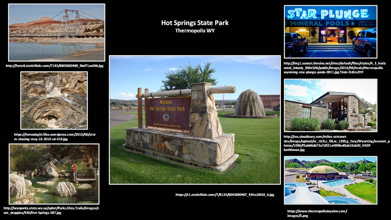
Hot Springs State Park – Within the state park there are trails to the river, springs, terraces, and overlooks. There is the State Bath House and two hot mineral water commercial swimming facilities at Hellie’s Tepee Pool and Star Plunge.
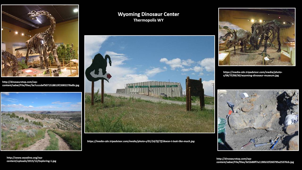
Wyoming Dinosaur Center – In addition to dinosaur exhibits and the bone preparation lab, they have a fine museum with a wide variety of fossils over geologic history displayed in a “Walk Thru Time”. From late-May through mid-September, they offer tours of the dig site and a “Dig For A Day” program where you can help them dig in the dinosaur bone beds.
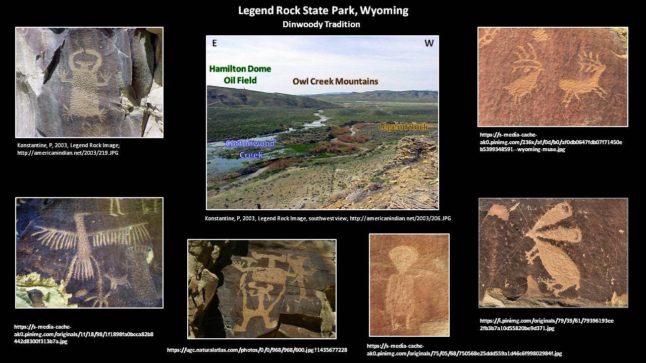
Legend Rock State Petroglyph Site - Located 29 miles northwest of Thermopolis, it has over 300 individual petroglyphs in 92 panels mainly in the Dinwoody tradition. Made during the past several thousand years, the figures include pecked animals, people and people-like features. There is a one-third mile loop trail with 15 numbered petroglyph stops along a cliff of Cretaceous Frontier Sandstone. The trail and cliff is next to Cottonwood Creek with the Hamilton Dome Oil Field just across the creek on the adjacent hill. Legend Rock is open May through September, 8 am to 6 pm. Access from October through April requires a key that can be picked up in Thermopolis at the State Bathhouse
Wyoming Whiskey - tours of plant in Kirby, thirteen miles north of Thermopolis

The material on this page is copyrighted
