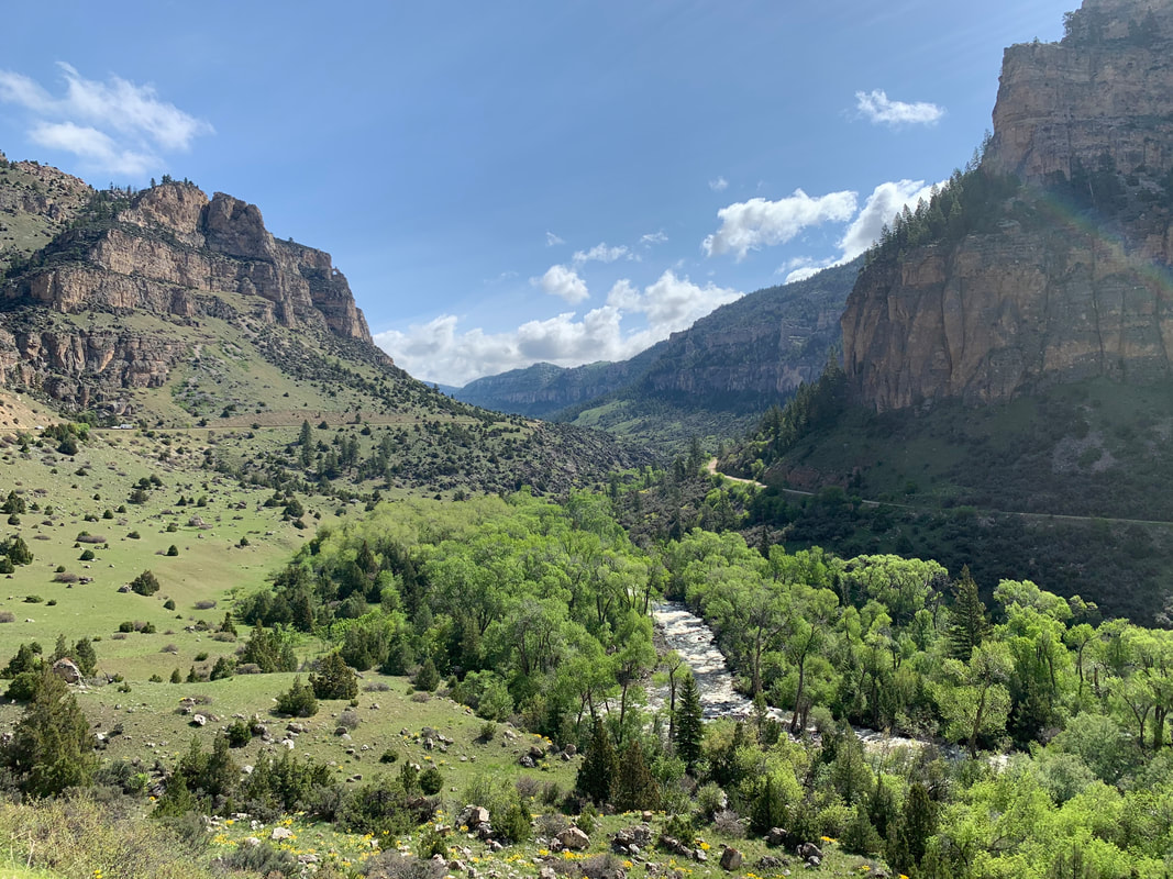
Tensleep Canyon
Picture by Mark Fisher
Picture by Mark Fisher
Wow Factor (4 out of 5 stars):

Geologist Factor (4 out of 5 stars):

Attraction
This area has it all if you like scenery, outdoor activity and rocks! A curving road from the basin to the top of the Bighorn Mountains with faults, canyons, cliffs, creeks, water falls, lakes, alpine wilderness, fish hatcheries, Nature Conservancy Preserve, fishing, boating, hikes, rock climbing, camping, ATV roads, horse trails, snowmobiling, cross country skiing and downhill skiing.
Geology of Tensleep Canyon
U.S. Highway 16 through the southern portion of the Bighorn Mountains is a passage marked by those who travelled this way in the past. The rocks underfoot record the evolution of Wyoming geology over 3.8 billion years. The highway was nicknamed “Sweet 16” because it presents the modern traveler with a scenic and safe route across this 90 mile long and 30 mile wide mountain range. Of the three highways over the Bighorns, U.S. 16 has the lowest grade and gentlest curves. You might also hear the highway from Tensleep to Buffalo called the Cloud Peak Skyway Scenic Byway. By whatever name you call it, the route remains an awe inspiring journey.
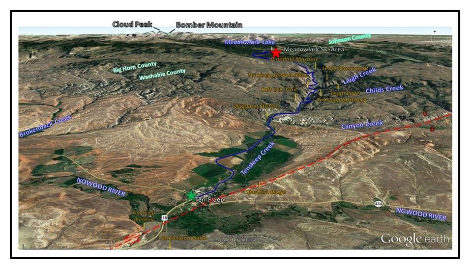
“Sweet 16” highway area from Ten Sleep (green star) to Meadowlark Lake Ski Area (red star) shown by dark blue line. Tensleep Fault shown by red dashed line. Other locations mark locations discussed in text.
Image: Google Earth
Image: Google Earth
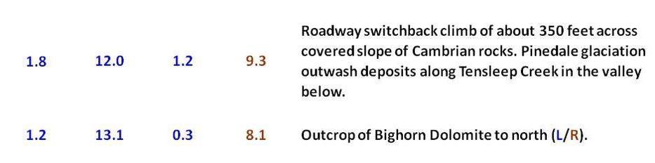
During the last Ice Age (Pinedale 110,000-11,700 BP), glacial ice formed at the crest of the Bighorn Mountains centered on Cloud Peak (13,167 feet ASL). Ice moved from the high mountains down through established stream valleys. The valleys shapes were modified from their “V” profile to the “U” profile by glacial erosion. Evidence also exists for the earlier Bull Lake (200,000-130,000 BP) and pre-Bull Lake Glaciation (1,200,000-200,000 B.P.) in some of these same valleys.
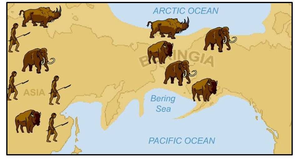
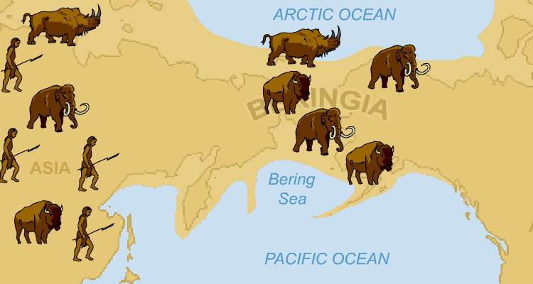
Global sea level dropped more than 300 feet during the ice ages and a land bridge called Beringia formed across the Bering Strait. This was an important gateway for migration of land animals such as bear, elk and bighorn sheep into North America. The abundance of the latter in the area is why Lewis and Clark named the range the Bighorn Mountains. Humans followed the game after 17,000 years BP. Beringia disappeared beneath the sea as the climate warmed at the end of the Ice Age about 11,000 years ago. DNA testing indicates that up to 80% of Native Americans today are direct descendants from Beringia Clovis people (Hogenboom, M., 2017, BBC Earth News).
Global sea level dropped more than 300 feet during the ice ages and a land bridge called Beringia formed across the Bering Strait. This was an important gateway for migration of land animals such as bear, elk and bighorn sheep into North America. The abundance of the latter in the area is why Lewis and Clark named the range the Bighorn Mountains. Humans followed the game after 17,000 years BP. Beringia disappeared beneath the sea as the climate warmed at the end of the Ice Age about 11,000 years ago. DNA testing indicates that up to 80% of Native Americans today are direct descendants from Beringia Clovis people (Hogenboom, M., 2017, BBC Earth News).
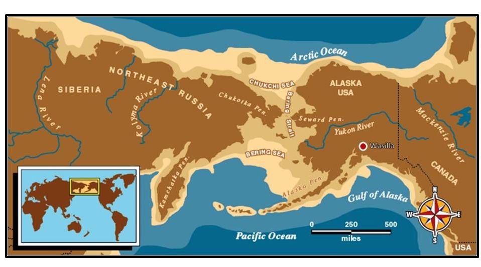
Beringia land bridge between Russia and Alaska at its maximum extent. This was an important migration path for mammals and plants between the continents. The red dot in top image is Sarah Palin's home town of Wasilla.
Images: Top: https://www.nps.gov/akso/beringia/beringia/B ; Bottom: http://www.learningliftoff.com/wp-content/uploads/2014/04/Bering-Land-Bridge.jpg
Images: Top: https://www.nps.gov/akso/beringia/beringia/B ; Bottom: http://www.learningliftoff.com/wp-content/uploads/2014/04/Bering-Land-Bridge.jpg
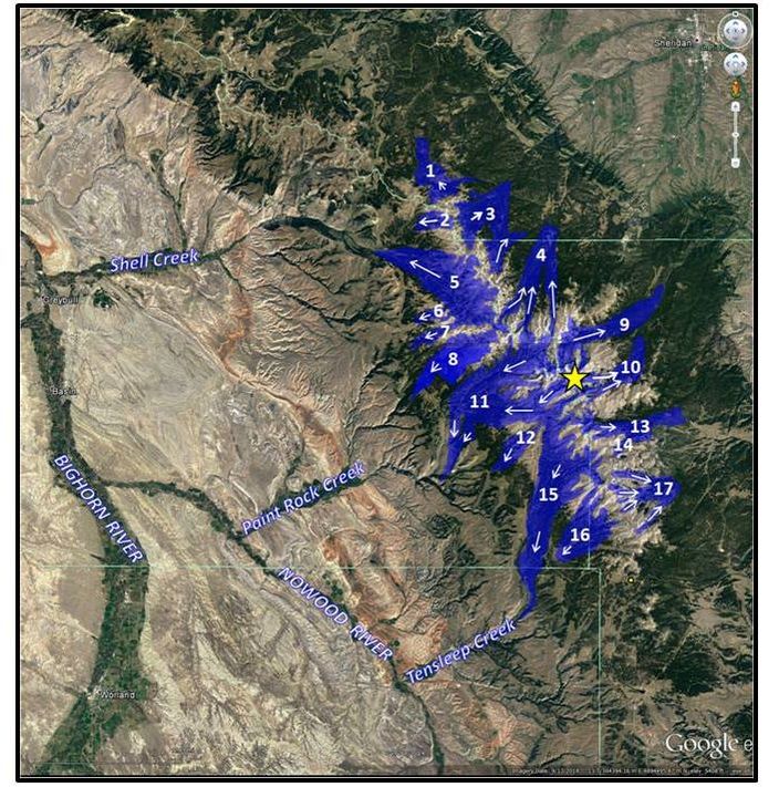
Cloud Peak. Glacial lobes: 1: Tongue River, 2: Willitt, 3: Dome Lake, 4: Lighter, 5: Shell Creek, 6: Trapper, 7: Medicine Lodge, 8: South Medicine Lodge, 9: Kearney, 10: Meade Lake, 11: Paintrock, 12: Buckskin Ed, 13: North Clear Creek, 14: Lake, 15: Tensleep, 16: East Tensleep, 17: South Clear Creek.
Image: Google Earth; Glacial Data: Darton, N.H., 1906, Geology of the Bighorn Mountains: USGS Professional Paper 51, Plate XXVIII, https://pubs.usgs.gov/pp/0051/report.pdf
Image: US National Park Service, 2006, https://www.nps.gov/bela/learn/historyculture/images/beringiamap1.jpg
Image: Google Earth; Glacial Data: Darton, N.H., 1906, Geology of the Bighorn Mountains: USGS Professional Paper 51, Plate XXVIII, https://pubs.usgs.gov/pp/0051/report.pdf
Image: US National Park Service, 2006, https://www.nps.gov/bela/learn/historyculture/images/beringiamap1.jpg
About the same time as Beringia was swallowed by the rising sea, Paleoamericans were hunting mammoths in the Bighorn Mountain area. The Colby Mammoth site (discovered in 1962) contained the remains of at least eight mammoths. A radiocarbon date of 11,200 + 250 years B.P. was obtained from this Clovis culture (~11,500-10,900 B.P.) kill site. Other mammoth remains had been found in the same area near Worland in 1907. The first trails through the range were made by animals as they traveled the stream valleys and connecting ridges in which glacial ice moved. Natural Trap Cave (see Geowyo Bighorn River Area Caves page) in the northern Bighorns contains the remains of animals from 25,000 years ago. Archaeologists have dated human presence in the vicinity over the last 10,000 to 12,000 years. The hunter gatherers followed the game trails through the mountains.
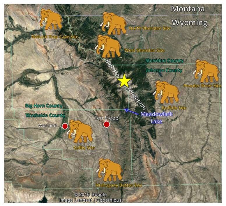
Mammoth sites in the Bighorn Mountains area. Cloud Peak location shown by yellow star.
Image: Google Earth; Data: Wilson, M., 1974, Applied Geology and Archaeology: The Holocene History of Wyoming: WSGS Report of Investigations No. 10, Fig. 3, p. 85. http://www.wsgs.wyo.gov/products/wsgs-1974-ri-10.pdf
Image: Google Earth; Data: Wilson, M., 1974, Applied Geology and Archaeology: The Holocene History of Wyoming: WSGS Report of Investigations No. 10, Fig. 3, p. 85. http://www.wsgs.wyo.gov/products/wsgs-1974-ri-10.pdf
In 1811, the Astorian Overland party of the Pacific Fur Company travelled through Powder River Pass (9,666 feet ASL) and down Tensleep Canyon in crossing the Bighorn Mountains on the second continental passage across America to Oregon territory. This expedition of 65 members was seeking a shorter, safer path to Fort Astoria that would avoid the aggressive Blackfeet Indians on Lewis and Clark’s Missouri River water route. Their path from the Pass to Ten Sleep closely followed the route of Highway 16.
People began to settle in Ten Sleep between 1880 and 1890. The Post Office was established in 1891 and serviced by a “Star Route” carrier. Army teamster Sam Stringer had the contract to deliver the post between Buffalo and Ten Sleep. His crossing of the Bighorns in the spring of 1892 is recorded in Marshall Cushing’s 1893 book The Story of Our Post Office: The Greatest Government Department in all its Phases. The winter of ’92 was particularly harsh and slow to end. Deep snow, frigid temperatures, stubborn mules, broken snow shoe, lack of provisions and sickness made this trek a testament to his loyalty to the unofficial Postal Creed: "Neither snow nor rain nor heat nor gloom of night stays these couriers from the swift completion of their appointed rounds." Postman Stringer’s bag contained one letter on his return trip. Sam not only survived this ordeal but he continued as a postal carrier for the rest of his life.
What follows is a 21 mile Roadlog from Ten Sleep to Meadowlark Lake along US Highway 16. Both the geology and history of this historic passage through the Bighorns will be noted. The US Forest Service designated this roadway a scenic byway in 1989. The state of Wyoming added the same designation in 1995.
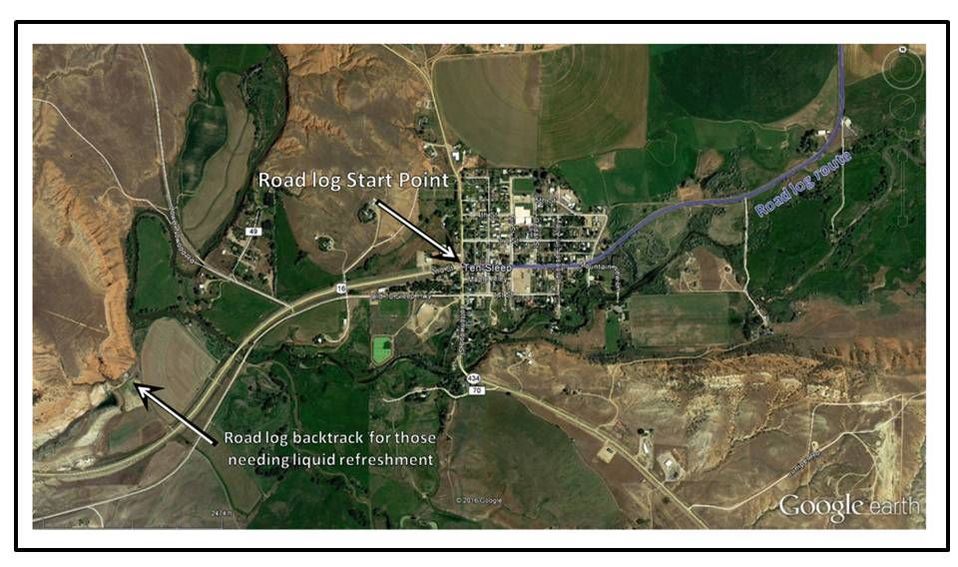
Ten Sleep, Wyoming aerial image.
Image: Google Earth
Image: Google Earth
Tensleep Canyon Geology Road Log

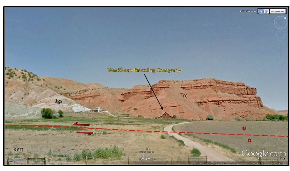
Ten Sleep Brewing Company about 1 mile west of Ten Sleep, north of US 16. Red dashed line shows approximate location of the Tensleep Fault. Geologic notation: Kmt: Cretaceous Mowry and Thermopolis Formations, Jgs: Jurassic Gypsum Spring, Trc: Triassic Chugwater Formation.
Image: Google Earth Street View
Image: Google Earth Street View
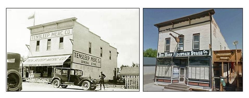
Tensleep Mercantile. Left: 1920s, Right: 2012
Images: Left: http://www.wyomingtalesandtrails.com/worland2.html, Right: Google Earth Street View
Images: Left: http://www.wyomingtalesandtrails.com/worland2.html, Right: Google Earth Street View

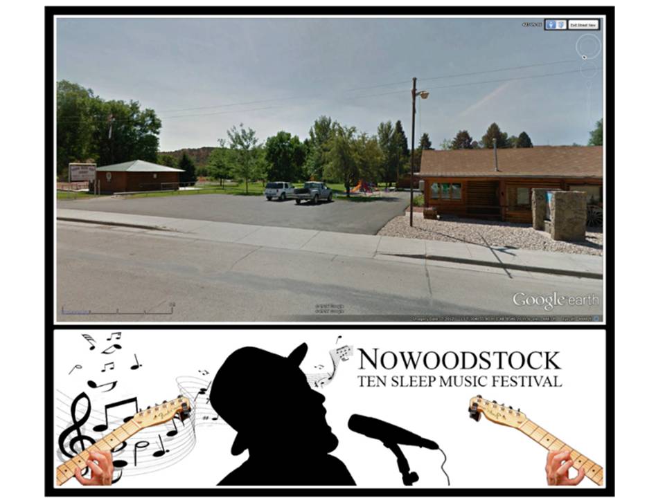
Pioneer Museum and Vista Park in Ten Sleep, Wyoming.
Image: Top: Google Earth Street View; Bottom: http://www.nowoodstock.com/index.cfm
Image: Top: Google Earth Street View; Bottom: http://www.nowoodstock.com/index.cfm
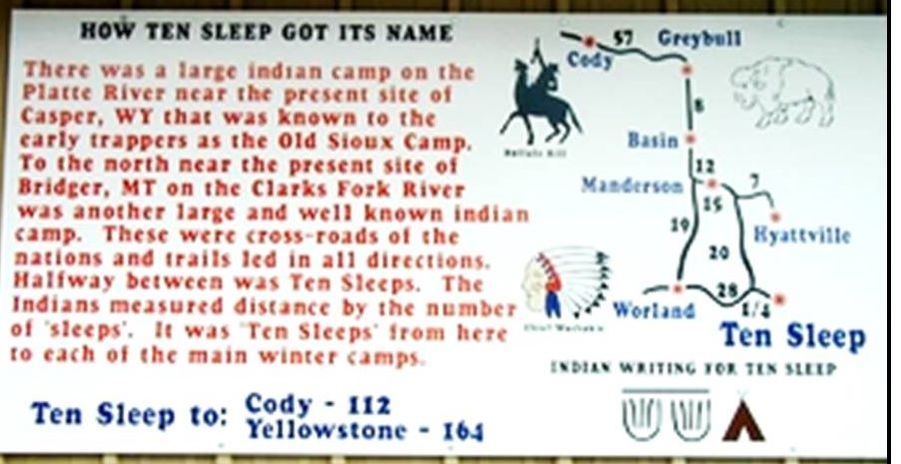
The origin of the town name.
Image: http://www.townoftensleep.com/images/301_tensleep-name.jpg
Image: http://www.townoftensleep.com/images/301_tensleep-name.jpg

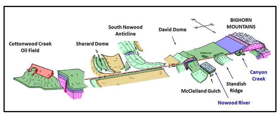
Cartoon diagram of major structural features along the west-east trending Tensleep Fault.
Image: After Allison, M.L., 1984, Structural Controls on a Stratigraphic Trap: The Cottonwood Creek Field, Bighorn Basin, Wyoming: WGA 35th Annual Field Conference Guidebook, Fig. 2, p. 357.
Image: After Allison, M.L., 1984, Structural Controls on a Stratigraphic Trap: The Cottonwood Creek Field, Bighorn Basin, Wyoming: WGA 35th Annual Field Conference Guidebook, Fig. 2, p. 357.
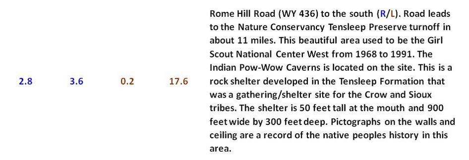
Left: Former Girl Scout National Center West area highlighted in green, now Nature Conservancy Tensleep Preserve. https://www.nature.org/ourinitiatives/regions/northamerica/unitedstates/wyoming/placesweprotect/tensleep-preserve.xml . Red Dashed line shows location of the Tensleep Fault. Right: Crow Sioux rock shelter.
Images: Left: Google Earth. Right: Image: Red Dirt in my Soul website, 2009, http://reddirtinmysoul.com/2009/09/01/fifteen-years-ago-and-a-few-days/
Images: Left: Google Earth. Right: Image: Red Dirt in my Soul website, 2009, http://reddirtinmysoul.com/2009/09/01/fifteen-years-ago-and-a-few-days/
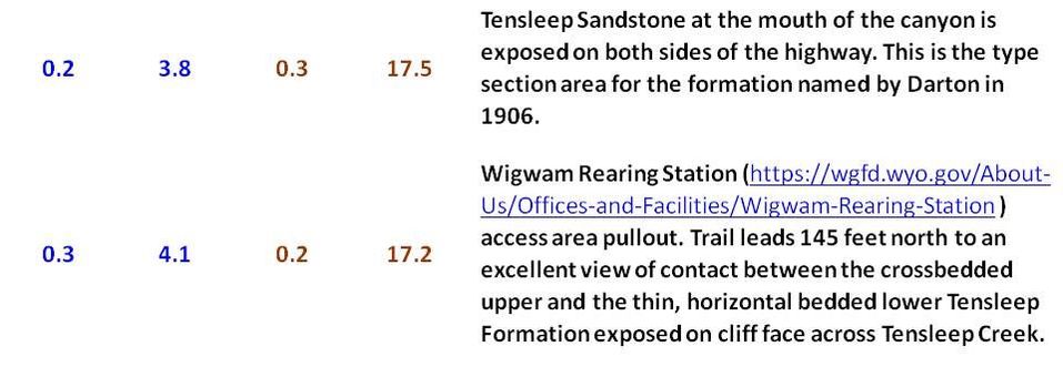
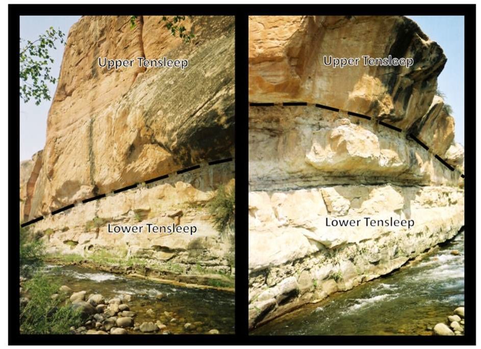
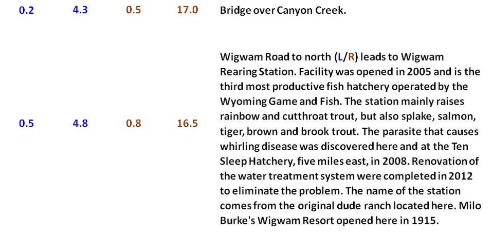
Tensleep Formation exposed along Tensleep Creek at Wigwam Rearing Station access pullout.
Image: Steele, K.K., 2007, Tensleep Creek
Image: Steele, K.K., 2007, Tensleep Creek
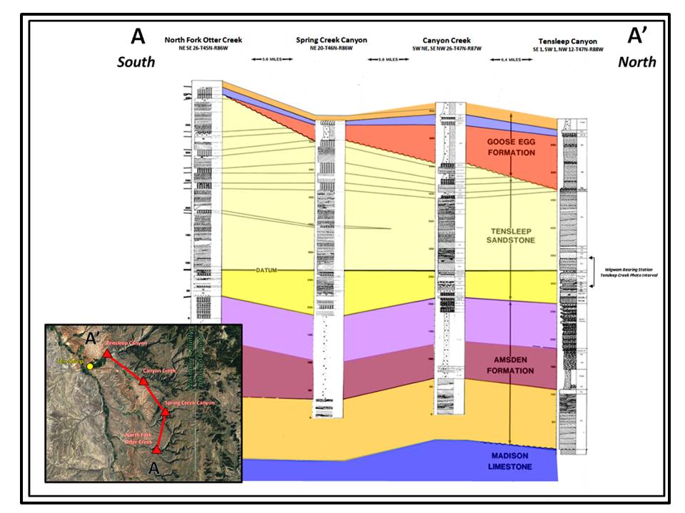
Regional Upper Paleozoic outcrop cross section.
Image: After Wheeler, D.M., 1986, Stratigraphy and Sedimentology of the Tensleep Sandstone, Southeast Bighorn Basin, Wyoming: M.S. Thesis, Colorado School of Mines, Plate 5, Cross Section A-A’ (part) https://dspace.library.colostate.edu/handle/11124/170478?show=full
Image: After Wheeler, D.M., 1986, Stratigraphy and Sedimentology of the Tensleep Sandstone, Southeast Bighorn Basin, Wyoming: M.S. Thesis, Colorado School of Mines, Plate 5, Cross Section A-A’ (part) https://dspace.library.colostate.edu/handle/11124/170478?show=full

Wigwam Road turn off Upper Paleozoic composite outcrop image. Geologic notation: Pt: Pennsylvanian Tensleep Formation, Par: Ranchester Limestone Member of the Pennsylvanian Amsden Formation, Pah: Horseshoe Shale Member of the Pennsylvanian Amsden Formation, Pa: Darwin Sandstone Member of the Pennsylvanian Amsden Formation.
Image: Google Earth Street View
Image: Google Earth Street View

Aerial view of Wigwam Rearing Station grounds.
Image: https://wgfd.wyo.gov/WGFD/media/content/About%20Us/Hatcheries/hatchery_wigwam_pic1.jpg
Image: https://wgfd.wyo.gov/WGFD/media/content/About%20Us/Hatcheries/hatchery_wigwam_pic1.jpg
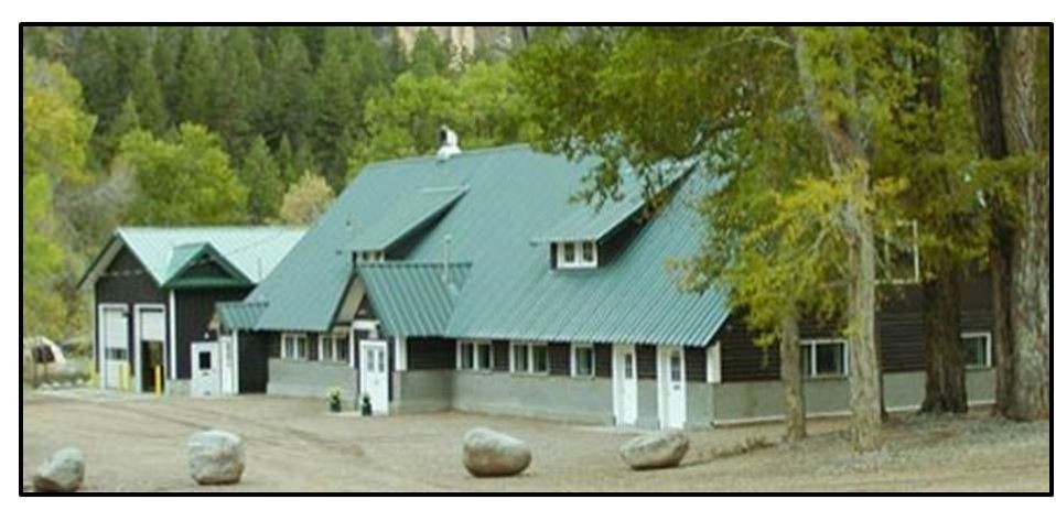
Tensleep Fish Hatchery on Old US 16 is the third oldest and one of the smallest stations operated by Wyoming Game and Fish. The facility renovation and rehabilitation was completed in 2011
Image: https://wgfd.wyo.gov/WGFD/media/content/About%20Us/Hatcheries/hatchery_tensleep_pic1.jpg
Image: https://wgfd.wyo.gov/WGFD/media/content/About%20Us/Hatcheries/hatchery_tensleep_pic1.jpg
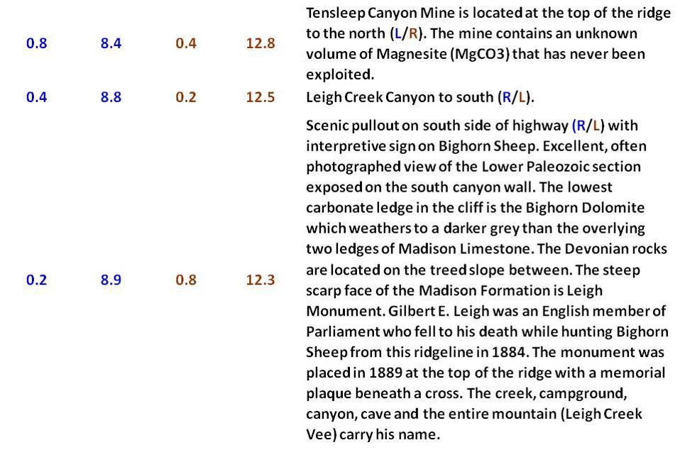
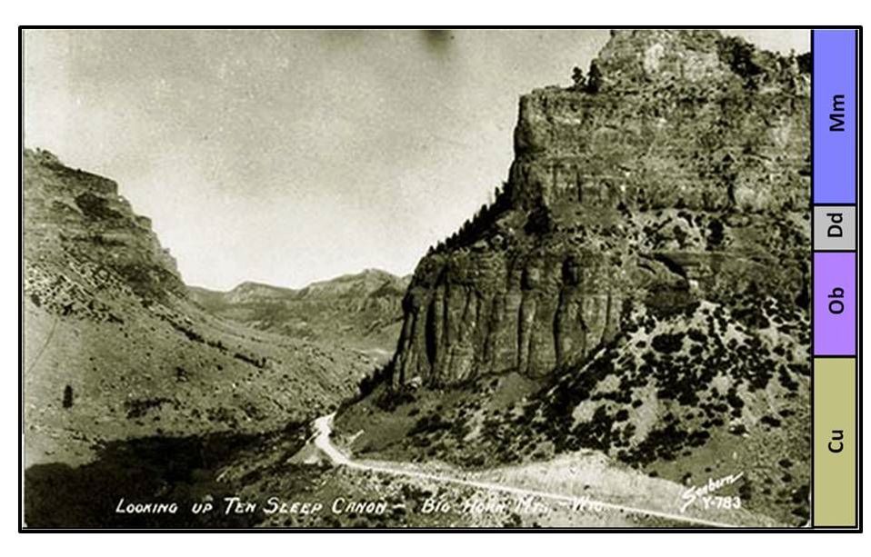
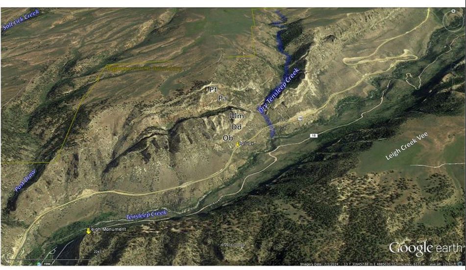
East view of Lower Paleozoic rocks in a 1,040 foot cliff face near Leigh Creek on the south side of Tensleep Creek. Note unpaved 1930s Old Hwy 16 roadway. Geologic notation: Mm: Mississippian Madison Formation, Dd: Devonian Darby Formation, Ob: Ordovician Bighorn Formation, Cu: Cambrian Gallatin and Gros Ventre Formations undifferentiated.
Image: Sanborn, W.P., 1930s, After http://wondersofwyoming.com/files/2012/03/120316-Ten-Sleep-Canyon.jpg
Image: Sanborn, W.P., 1930s, After http://wondersofwyoming.com/files/2012/03/120316-Ten-Sleep-Canyon.jpg
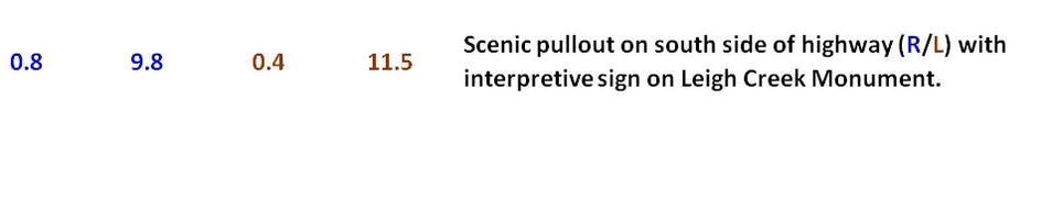

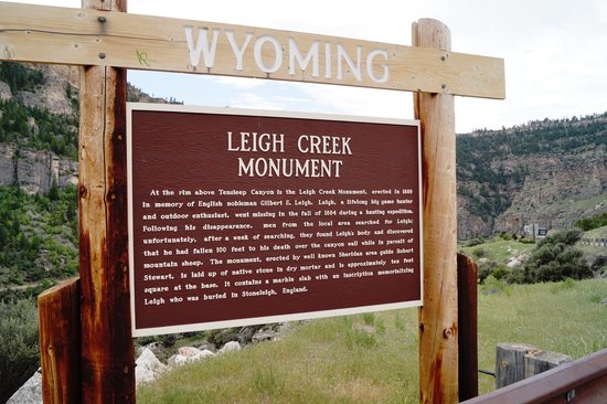
Leigh Monument interpretive sign.
Image: https://media-cdn.tripadvisor.com/media/photo-s/05/1b/a7/62/us-highway-16.jpg
Image: https://media-cdn.tripadvisor.com/media/photo-s/05/1b/a7/62/us-highway-16.jpg
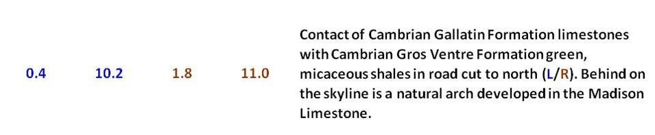
Gallatin/Gros Ventre Formations contact. Black rectangle shows area of natural arch developed in Madison Limestone (see image below). Geologic notation: Mm: Mississippian Madison Formation, Ob: Ordovician Bighorn Formation, Cg: Cambrian Gallatin Formation, Cgv: Cambrian Gros Ventre Formation.
Image: Google Earth Street View
Image: Google Earth Street View
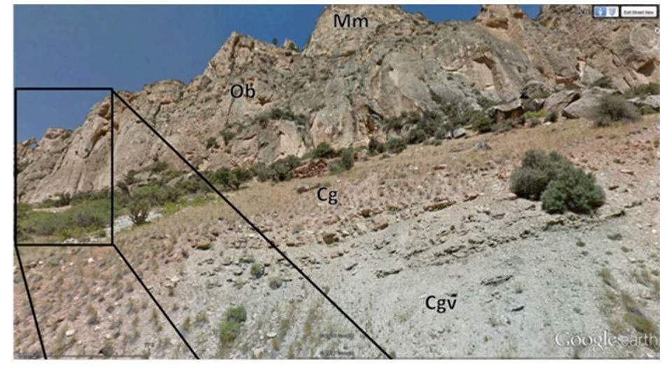
Enlarged image of natural arch.
Image: Google Earth Street View
Image: Google Earth Street View
Aerial view of Dry Tensleep Creek intermittent drainage highlighted in blue. Locations of the Cambrian Formations contact and Leigh Monument are also displayed.
Image: Google Earth Street View
Image: Google Earth Street View
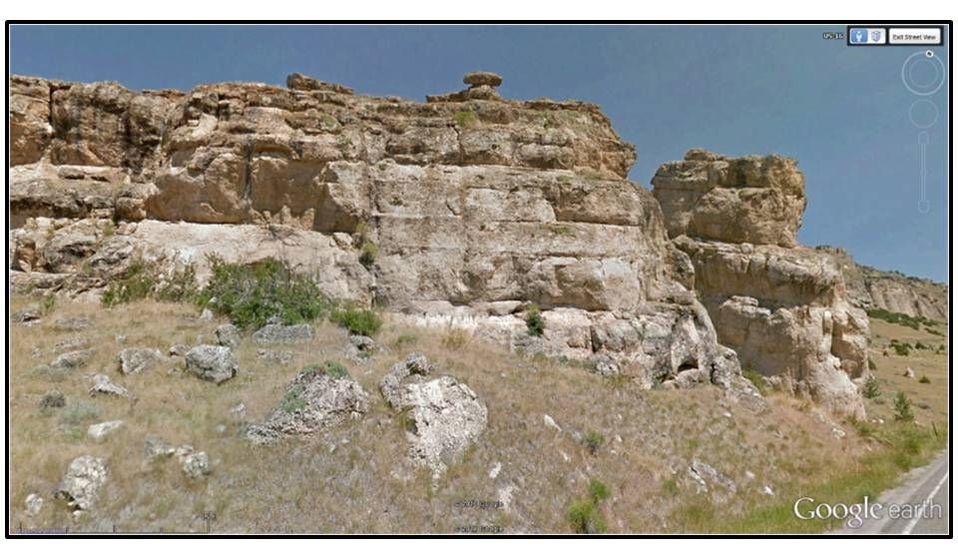
Ordovician Bighorn Dolomite along north (L/R) side of road.
Image: Google Earth Street View
Image: Google Earth Street View
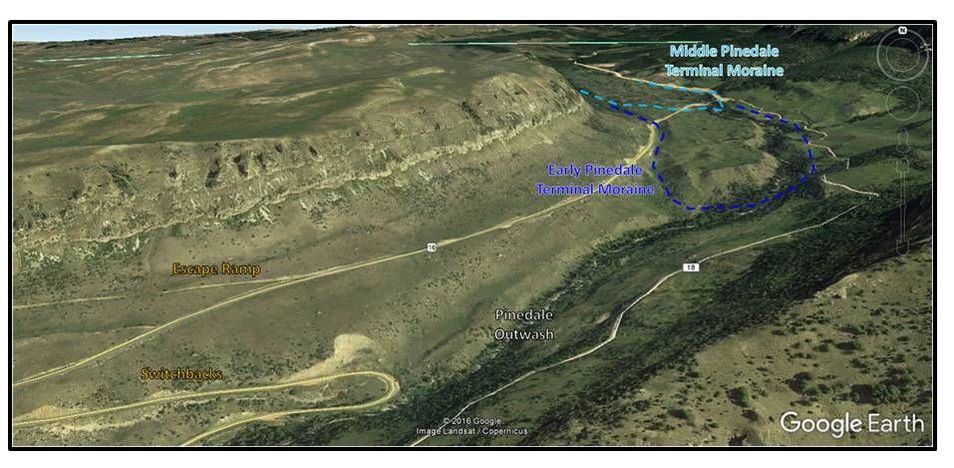
North aerial view of glacial features from the last ice age (Pinedale) along Tensleep Creek.
Image: Google Earth
Image: Google Earth

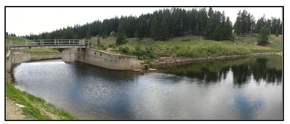
Upstream view of the 30-foot embankment of the Meadowlark Dam. The primary spillway is on the left.
Image: Meadowlark Site Photo, 2009, Appendix H, Technical Memorandum: Geologic Assessment, Fig. 7A, http://www.acewater.com/wp-content/uploads/2011/05/Nowood-Final-Report-APPENDIX-H.pdf
Image: Meadowlark Site Photo, 2009, Appendix H, Technical Memorandum: Geologic Assessment, Fig. 7A, http://www.acewater.com/wp-content/uploads/2011/05/Nowood-Final-Report-APPENDIX-H.pdf
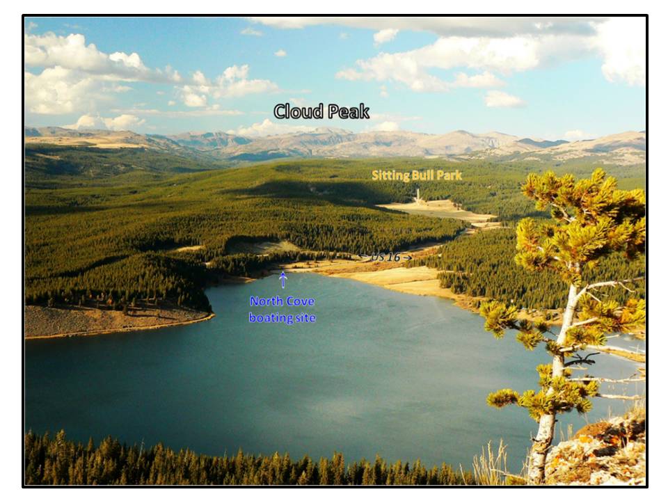
North aerial View of Meadowlark Lake with Cloud Peak on the skyline right of center.
Image: After USFS, https://www.fs.usda.gov/Internet/FSE_MEDIA/stelprd3812724.jpg
Image: After USFS, https://www.fs.usda.gov/Internet/FSE_MEDIA/stelprd3812724.jpg
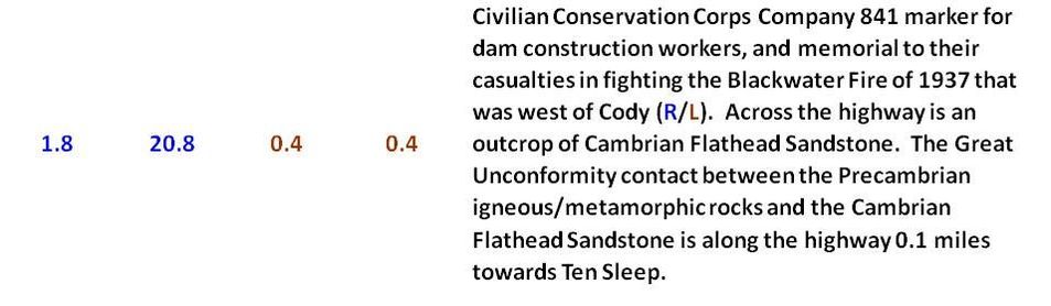
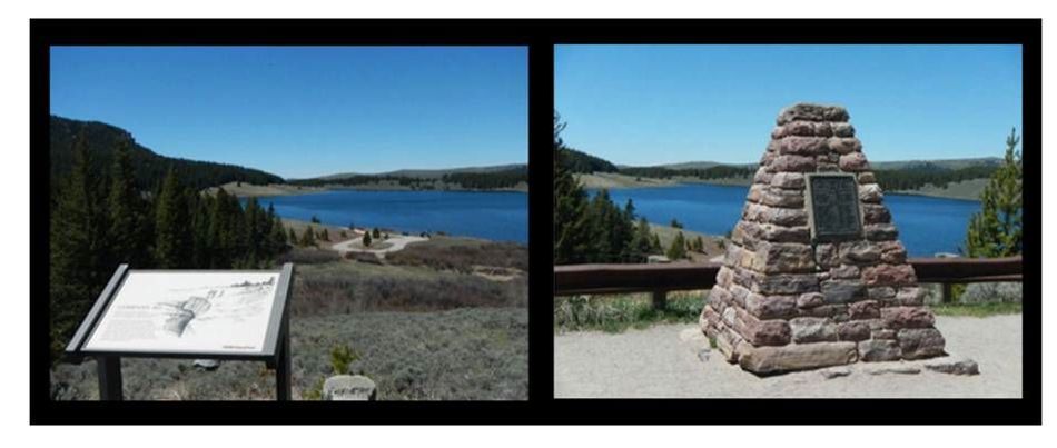
Company 841 Marker and Memorial.
Images: Swackhamer, B., 2016, Photos http://www.hmdb.org/marker.asp?marker=97888&Result=1
Images: Swackhamer, B., 2016, Photos http://www.hmdb.org/marker.asp?marker=97888&Result=1
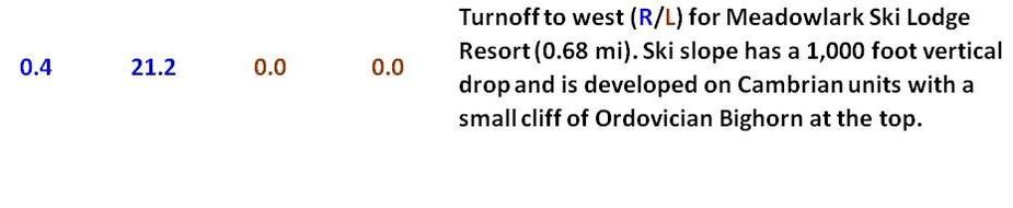
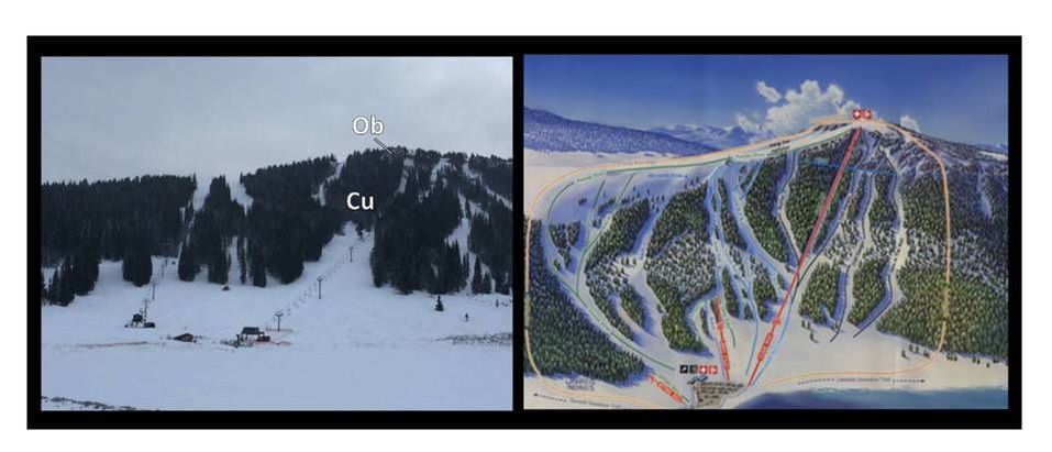
Meadowlark Ski Area. Geologic notation: Ob: Ordovician Bighorn Formation, Cu: undifferentiated Cambrian formations.
Images: Left: http://unofficialnetworks.com/2016/10/ski-hill-shoutout-meadowlark-ski-lodge-bighorn-mountain-range-wyoming Right: http://s3.onthesnow.com/images/trailmaps/wyoming/meadowlark-ski-lodge/20161211022536/large.jpg
Images: Left: http://unofficialnetworks.com/2016/10/ski-hill-shoutout-meadowlark-ski-lodge-bighorn-mountain-range-wyoming Right: http://s3.onthesnow.com/images/trailmaps/wyoming/meadowlark-ski-lodge/20161211022536/large.jpg
End of Road Log

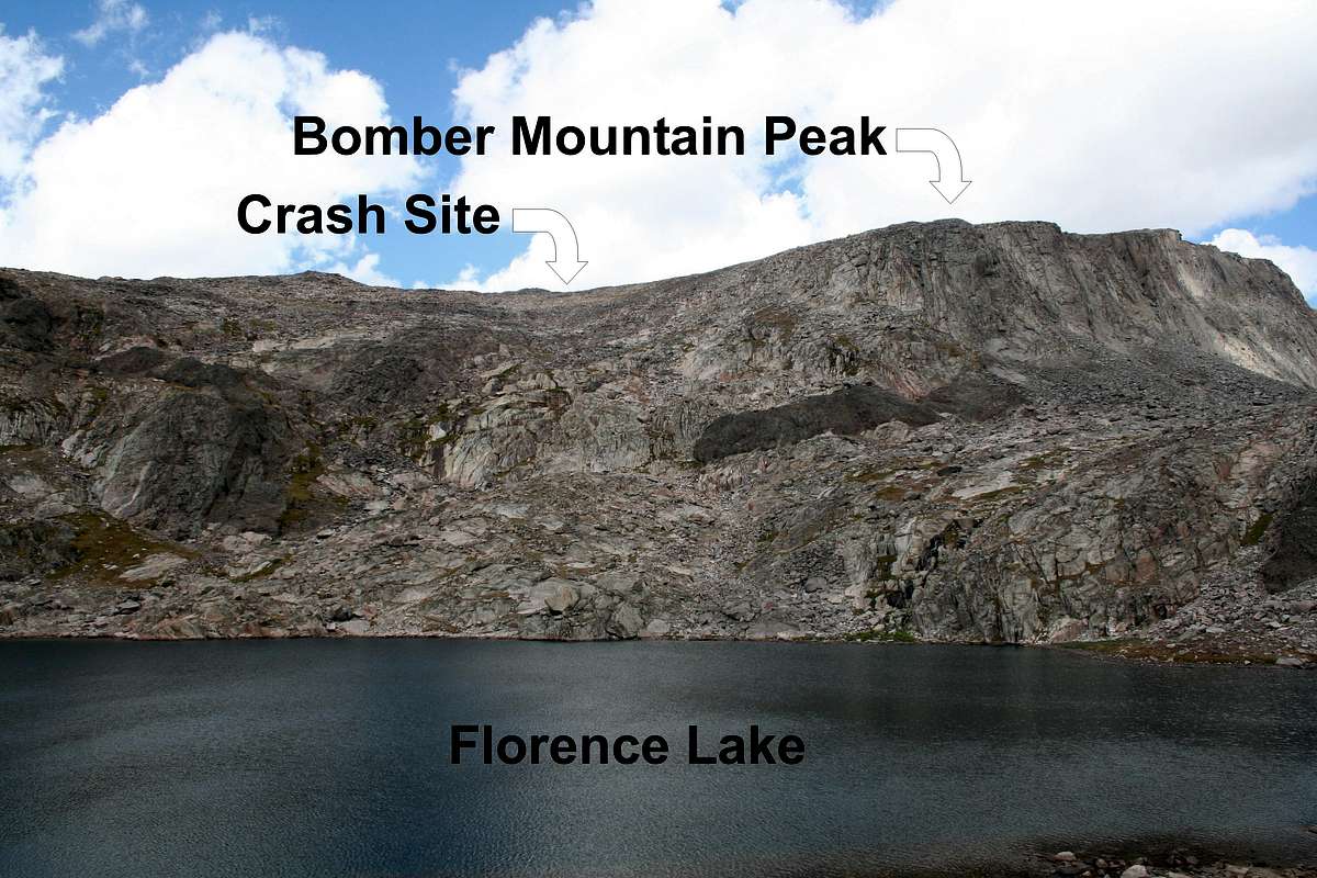
Bomber Mountain
As an Air Force brat, whose father flew in bombers in WWII, I was intrigued by the topographic featured name Bomber Mountain. This is what I learned.
In June 1943, a B-17 Flying Fortress nicknamed “Scharazad” disappeared on the second leg of a flight to Grand Island, Nebraska for deployment to the European theater during WWII. Two years later, about 100 days after the victory in Europe (VE day, 8 May 1945), two local cowboys found the crash site. It was located on a 12,480 foot, unnamed mountain ridge in the Bighorn Mountains, 1.5 miles south of Cloud Peak. The ridge was christened Bomber Mountain by the US Forest Service in 1946. A plaque was placed at the base of the mountain along the shore of Florence Lake in honor of the ten crew members who perished that summer night.
In June 1943, a B-17 Flying Fortress nicknamed “Scharazad” disappeared on the second leg of a flight to Grand Island, Nebraska for deployment to the European theater during WWII. Two years later, about 100 days after the victory in Europe (VE day, 8 May 1945), two local cowboys found the crash site. It was located on a 12,480 foot, unnamed mountain ridge in the Bighorn Mountains, 1.5 miles south of Cloud Peak. The ridge was christened Bomber Mountain by the US Forest Service in 1946. A plaque was placed at the base of the mountain along the shore of Florence Lake in honor of the ten crew members who perished that summer night.
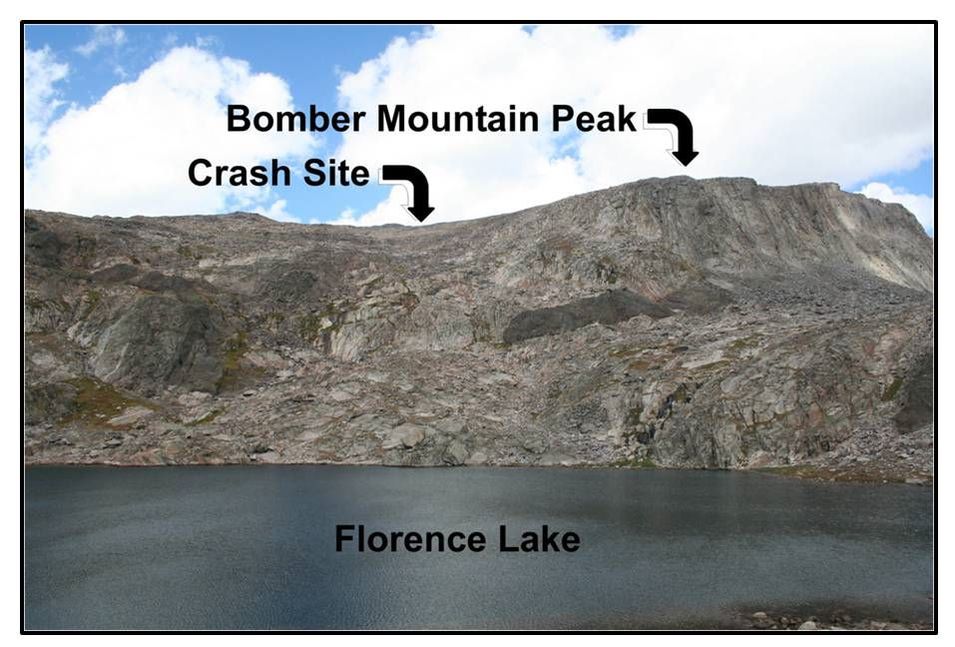
Scharazad crash site on Bomber Mountain.
Image: After Lehn, J., 2007, Summitpost.org, http://images.summitpost.org/original/334302.jpg
Image: After Lehn, J., 2007, Summitpost.org, http://images.summitpost.org/original/334302.jpg

Scharazad crash remains on Bomber Mountain.
Images: Lehn, J., 2007, Summitpost.org, http://images.summitpost.org/original/334302.jpg
Images: Lehn, J., 2007, Summitpost.org, http://images.summitpost.org/original/334302.jpg
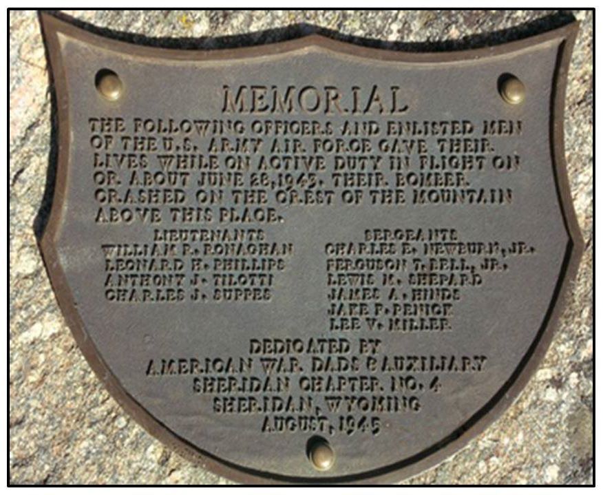
Memorial plaque for the crew of Scharazad. Note that the mountain was still unnamed when the plaque was installed.
Image: http://www.ultimatewyoming.com/sectionpages/sec3/images/bombermtnplaque.jpg
Image: http://www.ultimatewyoming.com/sectionpages/sec3/images/bombermtnplaque.jpg

Things to do in Tensleep area
Camping – Along FS 27 (West Tensleep Creek corridor) that starts at the Deer Haven turnoff 17.6 miles from Ten Sleep, there is Boulder Park CG, Island Park CG, Deer Park CG and West Tensleep Lake CG. There is also non-campground camping along FS 27 in numbered spots (you must have a port-a-potty). Near Meadowlark Lake, there is Lakeview CG, Sitting Bull CG and Willow Park Group CG. In the canyon near the Ten Sleep Fish Hatchery is the Leigh Creek CG on Wyoming 435/FS 18 at 7.6 miles from Ten Sleep. Forest Service campsite reservations can be made on-line. A lot of primitive camping by the rock climbing community occurs along FS 18 that parallels Highway 16. There is a horse friendly commercial RV park in Ten Sleep called Ten Broek. There is the Circle J retreat camp in the lower Tensleep Canyon that has camping and cabins.
Fishing – In addition to the stream fishing in Tensleep Creek, there is lake fishing at Meadowlark Lake and West Tensleep Lake and of course high country fishing in the lakes and streams of the Cloud Peak Wilderness. Here is the Wyoming Game & Fish website.
Hiking – There are stunning day, overnight and multi-day hikes into the Cloud Peak Wilderness. Two recommended hikes start at West Tensleep Lake. The first is up Middle Tensleep Creek to Mirror Lake & Lost Twin Lakes. The second is the gentle, but long trail up West Tensleep Creek to Lake Helen, Lake Marion, Mistymoon Lake, Gunboat Lake and Florence Pass. The West Tensleep Creek trail is also the popular starting route to Cloud Peak (2 to 3 day trip or one very long day if you are extreme). The website Summitpost gives details on numerous peaks in the Bighorns. A shorter hike to West Tensleep Falls starts in the same parking lot as the longer hikes, but heads south on trail 065. Take bug spray if you are hiking the high country in July or August. I have seen vortexes of mosquitoes looking for blood. Directions – coming 17.6 miles from Ten Sleep, turn left on FS 27 which is also the Deer Haven Lodge turnoff, continue 7.1 miles on FS 27 to West Tensleep Lake campground and trailhead.
John Sabin Lookout (High Park Lookout) – a kid friendly walk of 15 minutes, 200 vertical feet and 0.3 mile each way to the old fire lookout with great views of the Bighorn Mountains & Cloud Peak Wilderness to the north, Meadowlark Lake to northwest, the Bighorn Basin to west, Powder River Pass to the east and the plunge of the Bighorn Mountains to the south. It is a short scenic walk among trees, boulders and outcrops of the Bighorn Formation. These carbonates, some with fossil shells were deposited in a shallow sea on the west coast of the North American continent. Directions - coming 22.3 miles from Ten Sleep, turn right on FS 429, a dirt road that is OK for passenger cars. The turnoff is just 1.1 miles east of the turnoff for Meadowlark ski area. Once on the dirt road, 0.1 mile St Christopher’s of the Bighorns outdoor chapel on right (my daughter got married here), 0.4 mile cattle guard and side road intersection, go straight, 0.9 miles road splits, take right fork, 1.3 miles arrive at parking area. The covered slope from US 16 to the parking lot is Cambrian Shales.
Mountain Biking – Many of the trails open to mountain bikes are two tracks also open to ORVs. MTB Project shows a mountain bike trail near Meadowlark Lake. There is also a non-motorized trail taking off from Willow Park CG, Tyrell Work Center and Island Park CG toward East Tensleep Lake that I have not taken.
Nature Conservancy Tensleep Preserve is a beautiful area known for geology, wildlife, hiking, solitude, Ponderosa pines and Native American pictographs. It is tucked in the seldom visited southeast corner of the Bighorn Basin on the flanks of the Bighorn Mountains. Visitors are welcome Thursday through Sunday, May through mid-October, weather permitting. No dogs allowed. Recommended is a 3 mile round trip hike to Dedication Point at the edge of Canyon Creek Canyon with impressive views of Tensleep and Madison outcrops (see right picture below). Even more memorable is a short hike with five steam crossings of Canyon Creek to an alcove in the Tensleep Sandstone with ancient Native American pictographs (see left picture below). Dirt road access to the pictograph hike is through a locked gate that requires a code obtained from the office. Contact the Preserve ahead of your visit and for more information at 307-366-2671. Directions – Coming from Ten Sleep at 3.6 miles, turn right on WY 436, 4.1 miles anticline or geologic fold on left, Canyon Creek flowing from open meadows into a tight canyon of Tensleep Sandstone, 5.9 miles pavement ends, cattle guard, end WY 436 and start Washakie County 56, 7.1 miles pink and white rocks of Permian Goose Egg Formation, 14.2 miles entrance on left to Nature Conservancy Tensleep Preserve.
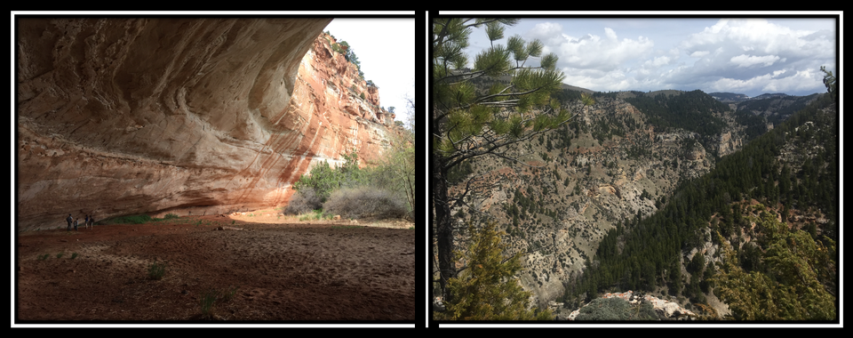
Nature Conservancy Tensleep Preserve. Left: alcove in Tensleep Sandstone on north side of Canyon Creek with ancient Native American pictographs. Right: northeast view from Dedication Point of Canyon Creek Canyon. Major benches from top to bottom are: Tensleep Sandstone above red layer, Amsden shale is the recessed red layer, Darwin Sandstone immediately below red layer, and Madison Formation at base.
Pictures by Mark Fisher
Pictures by Mark Fisher
Off-Road Vehicles (ORVs) – The west flank of the Bighorns is ORV heaven with endless miles of dirt roads and two-track trails on Forest Service and BLM land. For information, check out the Bighorn National Forest ORV webpage and the Wyoming State Trails Program webpage with ORV maps.
Rock Climbing - Tensleep Canyon is a premier rock climbing destination known for single-pitch sport climbing (permanent anchors) on limestone and dolomite. The Bighorn Climbers Coalition is a local source of information. Mountain Project website can get you oriented with over 500 listed climbing routes in the canyon, or you can buy the climbing guidebook “Holy Ten Sleep: Electric Koolaide 3-D Acid Test” at http://extremeangles.com/
Ten Sleep Fish Hatchery and Wigwam Rearing Station – Two separate, but similar facilities run by the Wyoming Game & Fish that are open to visitors and kid friendly. Both are neat and it is hard to recommend one over the other. Wigwam is in a pretty spot with Cottonwood trees, Tensleep Sandstone outcrops and old outdoor fish raceways, whereas the Ten Sleep Hatchery is in a gorgeous and peaceful location in the canyon just upstream of where Leigh Creek joins Tensleep Creek. Directions - Wigwam coming 4.8 miles from Ten Sleep, turn left on entrance road; Ten Sleep Fish Hatchery coming 7.6 miles from Ten Sleep, turn right on Wyoming 435/FS 18, go 1.1 miles. Look for the guys and gals in the red G&F shirts if you have questions.

The material on this page is copyrighted