Geology of Wyoming
  • Home
    • Wow Factor
    • Geological Factor
    • Stratigraphic Column
    • Wyoming Links
    • About The Geologists
    • Contact Us
  • Map of GeoWyo Top Spots
  • Albany-Laramie Counties
    • Big Hollow
    • Como Bluff
    • Snowy Range Stromatolites
    • Sybille Canyon - WY Highway 34
    • Vedauwoo
    • Wyoming Diamonds
  • Big Horn County
    • Ancient River Channel & Sheep Mountain
    • Bighorn Canyon
    • Bighorn Mountain Byways Part I
    • Bighorn River Area Caves
    • Devil's Kitchen
    • Medicine Lodge Tensleep Sandstone
    • Red Gulch Alkali Backcountry Byway
    • Red Gulch Dinosaur Tracksite & Sundance Seaway
    • Shell Dinosaur Bone Beds
  • Campbell County
    • Pumpkin Buttes
  • Carbon County
    • Battle Pass Byway - WY Highway 70
    • Encampment & Sierra Madre Mtns
    • Freezeout Hills
    • Rawlins Uplift
    • Shirley Basin
  • Converse County
    • Ayres Natural Bridge
    • Douglas Crater Field
  • Crook County
    • Devils Tower & Black Hills
  • Fremont County
    • Gas Hills & Crooks Gap Uranium
    • Red Canyon
    • Sinks Canyon
    • South Pass
  • Goshen-Platte Counties
    • Fort Laramie & Hartville Uplift
    • Goshen Hole
  • Hot Springs County
    • Anchor Dam
    • Dinosaur Marbles
    • Thermopolis Hot Springs
    • Wind River Canyon Part 1
    • Wind River Canyon Part 2
  • Johnson County
    • Hole In The Wall & Red Wall Country
  • Laramie County
    • Cheyenne Tablelands and Gangplank
  • Lincoln County
    • Fossil Butte
    • Periodic Spring
  • Natrona County
    • Bessemer Bend
    • Casper Mountain
    • Ervay Basin
    • Granite Mountains
    • Hells Half Acre
    • Rattlesnake Hills
  • Niobrara County
    • Lusk Area
  • Park County
    • Absaroka Volcanic Province
    • Beartooth Highway
    • Buffalo Bill Dam & Rattlesnake Mtn.
    • Clarks Fork Canyon
    • Cody Hydrothermal System
    • Dead Indian Hill
    • The Great Unconformity
    • Heart Mountain
    • Kirwin
    • Oregon Basin Oil Field
    • McCullough Peaks
    • Polecat Bench & PETM
    • Sunlight Basin
    • Tatman Mountain & Squaw Peaks
  • Sheridan County
    • Bighorn Mountain Byways Part II
  • Southeast Wyoming
    • North Platte River: One Dammed Thing After Another
  • Southern Powder River Basin
    • K-T Boundary
  • Sublette County
    • Titcomb Basin
  • Sweetwater County
    • Adobe Town
    • Flaming Gorge
    • Lake Gosiute & the Blue Forest
    • Leucite Hills
  • Teton County
    • Gros Ventre Range & Granite Hot Springs
    • Northern Tetons Geologic Wonders
    • Two Ocean Pass
  • Uinta-Lincoln Counties
    • Wyoming Thrust Belt
  • Washakie County
    • Big Cedar Ridge
    • Castle Gardens
    • Tensleep Canyon & Sweet 16
    • Upper Nowood River Valley
  • MONTANA
    • Crazy Mountains and Basin
    • Grasshopper Glacier
    • Nye-Bowler Fault Zone
    • Pryor Mountains
    • Red Lodge - Bear Creek Coal

GeoWyo Top Spots

Wyoming has everything that excites a geologist! 
For over 100 years, Wyoming has attracted geologists in search of oil, gas and mineral wealth as well as research geologists challenged by complex geology.  It has the full spectrum of why a person would pick a career in geology: fossils to minerals, mountains to basins, folds and faults, igneous to sedimentary rocks, mines to oil fields, geothermal features to glacial features and best of all plentiful outcrops. Access is superb with roughly half of the state owned by the federal government.  Add in western hospitality, spectacular scenery, abundant wildlife, low humidity and over 200 total days with sun and you will realize why we love Wyoming.  It is heaven on earth for a geologist and we hope that you can experience a little of that heaven too!
Picture of Pat O'Hara Mountain, Park County, Wyoming
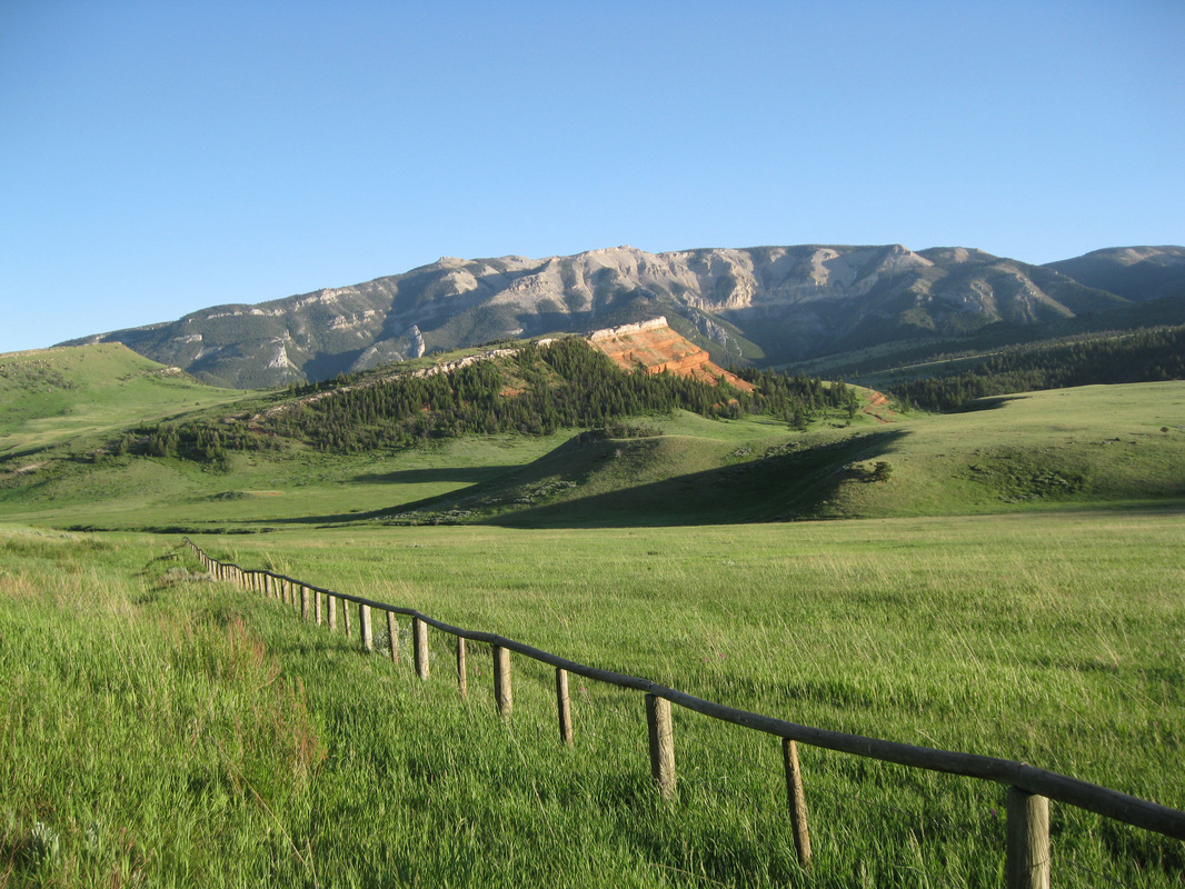
Chugwater outcrop and Pat O'Hara Mountain,  picture taken along Chief Joseph Highway, northwest Wyoming
​Image by Mark Fisher


Ratings...

​We built this website so you can select special geological spots that match your interests and then see and learn about the geology.  For each spot we provide a wow rating, a geological factor rating, an attraction summary, a detailed geology description with maps, diagrams, pictures and history, what you will see, driving directions, and for most spots a recommended hike or activity.  
Wow Factor --
Will I be impressed?  Is it magical?  This is a one to five star rating scale with one star being pleasant and five stars having the potential for a special moment and lasting memory.
Geological Factor -- 
Will it put goose bumps on a geologist’s arm?  Only emotions stirred by geological or intellectual stimuli are rated in this category from one to five stars.
Picture pf Avalanche Peak, Yellowstone National Park
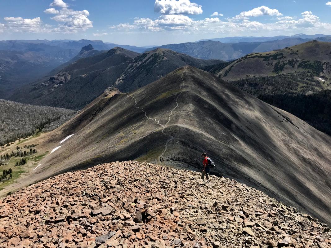
Avalanche Peak, Yellowstone National Park.
Picture

Warning!

Geowyo and the authors assume no responsibility or liability for any damages, losses, accidents, or injuries incurred by readers who visit the places or engage in activities described on this website. It is the reader’s responsibility to be aware of all risks and take the necessary precautions to handle those risks. The suggestions, “Wow Factor”, and “Geologist Factor” on this website are strictly the author’s opinion and expressed to help you make a decision on whether to visit these places. You are responsible for making your own judgement on the worthiness of these places. 

Geowyo and the authors make no representation or warranty, expressed or implied, regarding the use, accuracy, or completeness of the data presented. We disclaim any responsibility or liability for interpretations made from these data.
Picture

​The material on this page is copyrighted

Proudly powered by Weebly
  • Home
    • Wow Factor
    • Geological Factor
    • Stratigraphic Column
    • Wyoming Links
    • About The Geologists
    • Contact Us
  • Map of GeoWyo Top Spots
  • Albany-Laramie Counties
    • Big Hollow
    • Como Bluff
    • Snowy Range Stromatolites
    • Sybille Canyon - WY Highway 34
    • Vedauwoo
    • Wyoming Diamonds
  • Big Horn County
    • Ancient River Channel & Sheep Mountain
    • Bighorn Canyon
    • Bighorn Mountain Byways Part I
    • Bighorn River Area Caves
    • Devil's Kitchen
    • Medicine Lodge Tensleep Sandstone
    • Red Gulch Alkali Backcountry Byway
    • Red Gulch Dinosaur Tracksite & Sundance Seaway
    • Shell Dinosaur Bone Beds
  • Campbell County
    • Pumpkin Buttes
  • Carbon County
    • Battle Pass Byway - WY Highway 70
    • Encampment & Sierra Madre Mtns
    • Freezeout Hills
    • Rawlins Uplift
    • Shirley Basin
  • Converse County
    • Ayres Natural Bridge
    • Douglas Crater Field
  • Crook County
    • Devils Tower & Black Hills
  • Fremont County
    • Gas Hills & Crooks Gap Uranium
    • Red Canyon
    • Sinks Canyon
    • South Pass
  • Goshen-Platte Counties
    • Fort Laramie & Hartville Uplift
    • Goshen Hole
  • Hot Springs County
    • Anchor Dam
    • Dinosaur Marbles
    • Thermopolis Hot Springs
    • Wind River Canyon Part 1
    • Wind River Canyon Part 2
  • Johnson County
    • Hole In The Wall & Red Wall Country
  • Laramie County
    • Cheyenne Tablelands and Gangplank
  • Lincoln County
    • Fossil Butte
    • Periodic Spring
  • Natrona County
    • Bessemer Bend
    • Casper Mountain
    • Ervay Basin
    • Granite Mountains
    • Hells Half Acre
    • Rattlesnake Hills
  • Niobrara County
    • Lusk Area
  • Park County
    • Absaroka Volcanic Province
    • Beartooth Highway
    • Buffalo Bill Dam & Rattlesnake Mtn.
    • Clarks Fork Canyon
    • Cody Hydrothermal System
    • Dead Indian Hill
    • The Great Unconformity
    • Heart Mountain
    • Kirwin
    • Oregon Basin Oil Field
    • McCullough Peaks
    • Polecat Bench & PETM
    • Sunlight Basin
    • Tatman Mountain & Squaw Peaks
  • Sheridan County
    • Bighorn Mountain Byways Part II
  • Southeast Wyoming
    • North Platte River: One Dammed Thing After Another
  • Southern Powder River Basin
    • K-T Boundary
  • Sublette County
    • Titcomb Basin
  • Sweetwater County
    • Adobe Town
    • Flaming Gorge
    • Lake Gosiute & the Blue Forest
    • Leucite Hills
  • Teton County
    • Gros Ventre Range & Granite Hot Springs
    • Northern Tetons Geologic Wonders
    • Two Ocean Pass
  • Uinta-Lincoln Counties
    • Wyoming Thrust Belt
  • Washakie County
    • Big Cedar Ridge
    • Castle Gardens
    • Tensleep Canyon & Sweet 16
    • Upper Nowood River Valley
  • MONTANA
    • Crazy Mountains and Basin
    • Grasshopper Glacier
    • Nye-Bowler Fault Zone
    • Pryor Mountains
    • Red Lodge - Bear Creek Coal