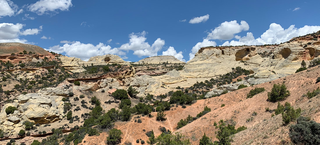
Tensleep Sandstone in Alkali Creek Wilderness Study Area
Picture by Mark Fisher
Picture by Mark Fisher
Wow Factor (3 out of 5 stars):
Geologist Factor (4 out of 5 stars):
Attraction
Geology, scenic views, solitude, exploring foothills of Bighorn Mountains at a leisurely slow pace, optional side trip to Trapper Canyon Tar Sand.
Geology of Red Gulch Alkali Backcountry Byway
The route from the intersection of US-14 and Red Gulch Road climbs from the Shell Creek valley to the foothills bench along the west flank of the Bighorn Mountains. The backcountry byway is located on a folded structural bench elevated by the westward directed Potato Ridge Thrust onto the eastern edge of the Greybull Platform. Shell Dome and Cherry Creek Anticline are asymmetric folds developed on that monoclinal bench. Wildcat wells drilled since the late 1950s for oil and gas on these structures were unproductive in the Phosphoria and Tensleep reservoirs.
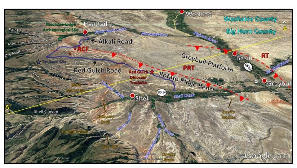
South aerial view of Red Gulch Alkali Backcountry Byway area. Potato Ridge Thrust (PRT) and Rio Thrust (RT) are shown by dashed red lines with red triangles pointing in the direction of fault plane dip. Alkali Creek Normal Fault (ACF) is shown by solid red line with relative motion indicated by “U” (up) and “D” (down). Location of structural cross section A-A’ (figure below) indicated by solid yellow line.
Image: Google Earth
Image: Google Earth
Structural cross section across the Bighorn Mountains showing the Greybull Platform and Potato Ridge Monocline on the western flank of the uplift. RT: Rio Thrust, PRT: Potato Ridge Thrust, SBCT: South Beaver Creek Thrust (note this fault is “blind” here and does not cut the sedimentary rocks above but forms a steep monocline), PCT: Piney Creek Thrust.
Image: After Stone, D.S., 2004, Rio Thrusting, Multi-Stage Migration, and Formation of Vertically Segregated Paleozoic Oil Pools At Torchlight Field On the Greybull Platform (Eastern Bighorn Basin): Implications For Exploration: RMAG The Mountain Geologist, Vol. 41, No. 3, Fig. 2, p. 121.
Image: After Stone, D.S., 2004, Rio Thrusting, Multi-Stage Migration, and Formation of Vertically Segregated Paleozoic Oil Pools At Torchlight Field On the Greybull Platform (Eastern Bighorn Basin): Implications For Exploration: RMAG The Mountain Geologist, Vol. 41, No. 3, Fig. 2, p. 121.
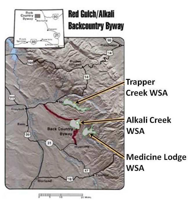
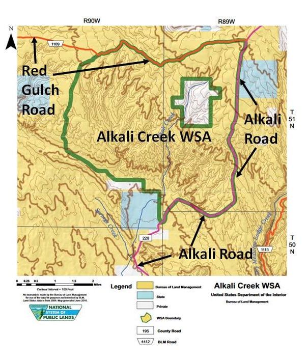
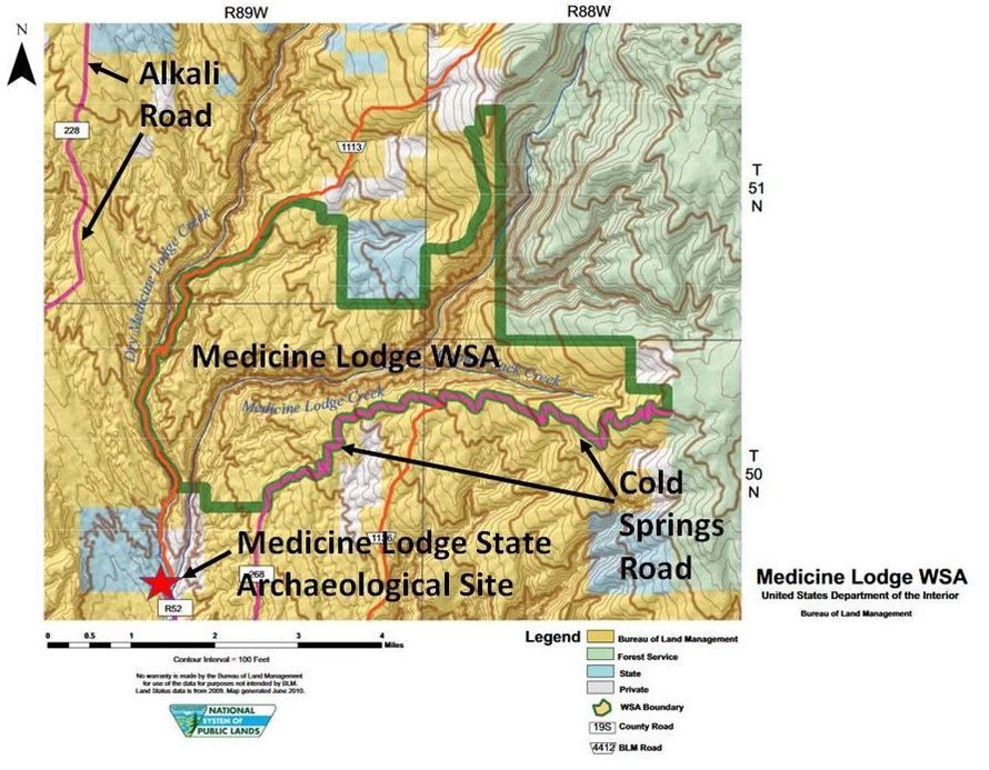
The scenic landscape of the western slope of The Bighorn Mountains is spectacular. The view from the road across the flat of Potato Ridge surface is broken by deeply eroded canyons that display the multiple colors of the rock formations. The byway also passes near three wilderness study areas (WSA): Trapper Creek, Alkali Creek and Medicine Lodge.
Bureau of Land Management Wilderness Study Areas adjacent to byway.
Image: BLM
Image: BLM
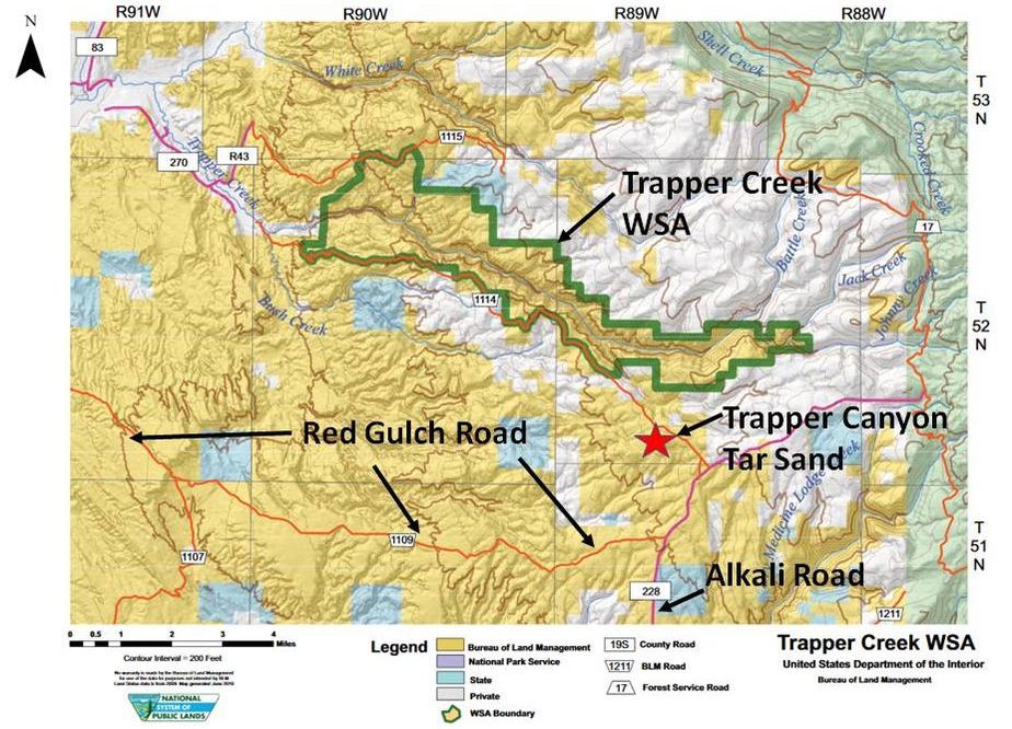
Trapper Creek Wilderness Study Area BLM Map. If you take the optional side trip to the Trapper Canyon Tar Sand, that same two-track 4WD high clearance road (1114) continues to the southern edge of the Trapper Creek WSA.
Image: BLM
Image: BLM
Alkali Creek Wilderness Study Area BLM Map. The Byway is adjacent to the Alkali Creek WSA on the north and east sides.
Image: BLM
Image: BLM
Medicine Lodge Wilderness Study Area BLM map. The easiest access to this WSA is via the Medicine Lodge State Archaeological Site or the Cold Springs Road. See Geowyo Medicine Lodge Tensleep Sandstone page for details on this area.
Image: BLM
Image: BLM
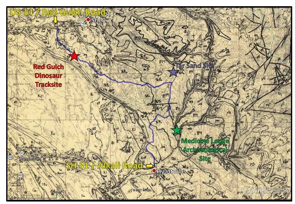
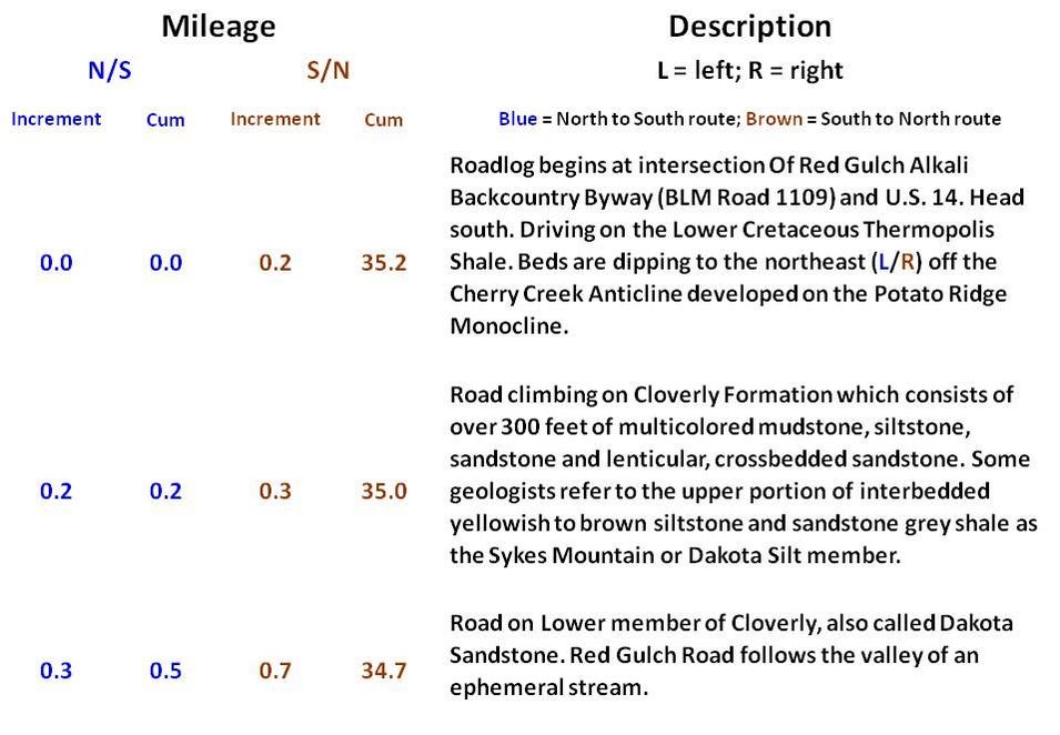
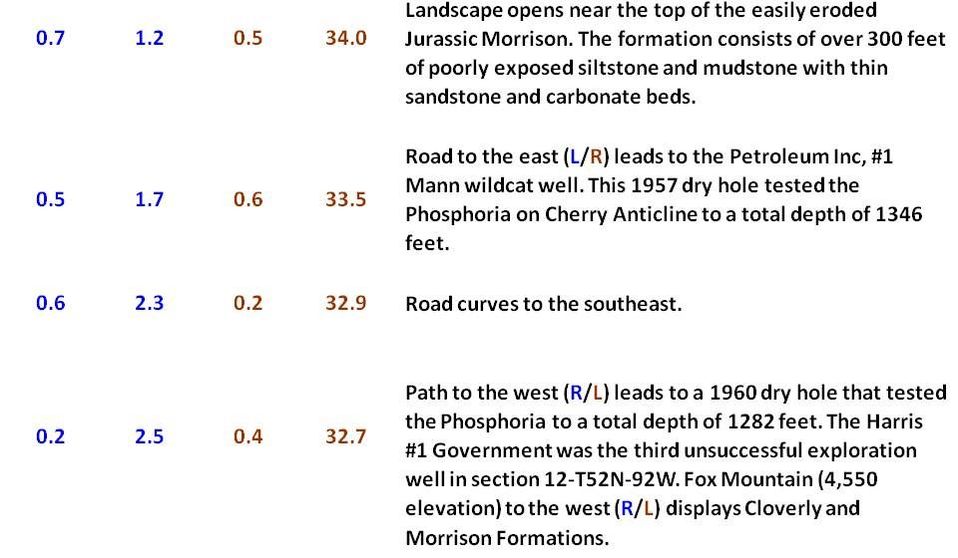
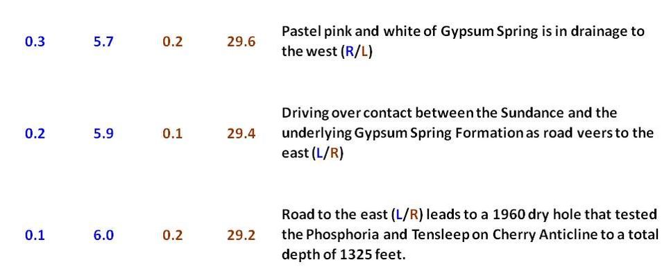
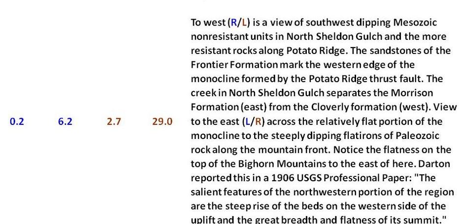
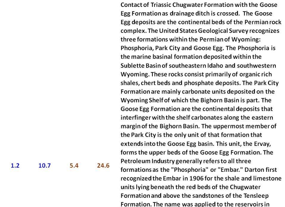
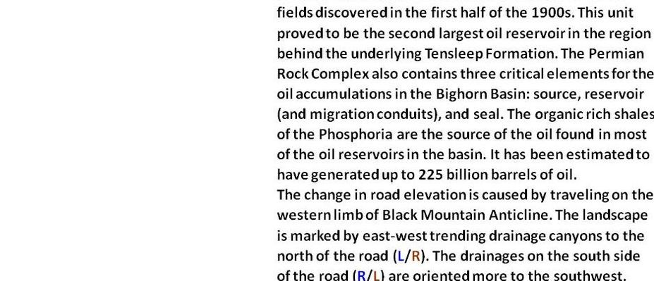
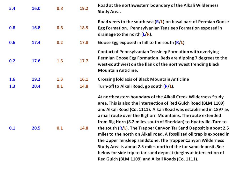
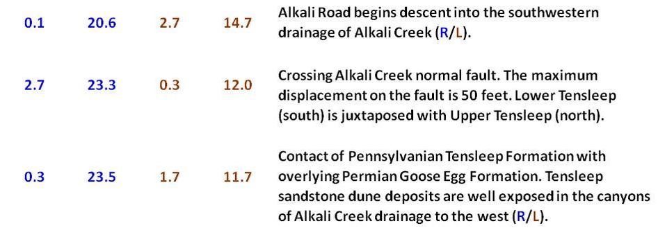
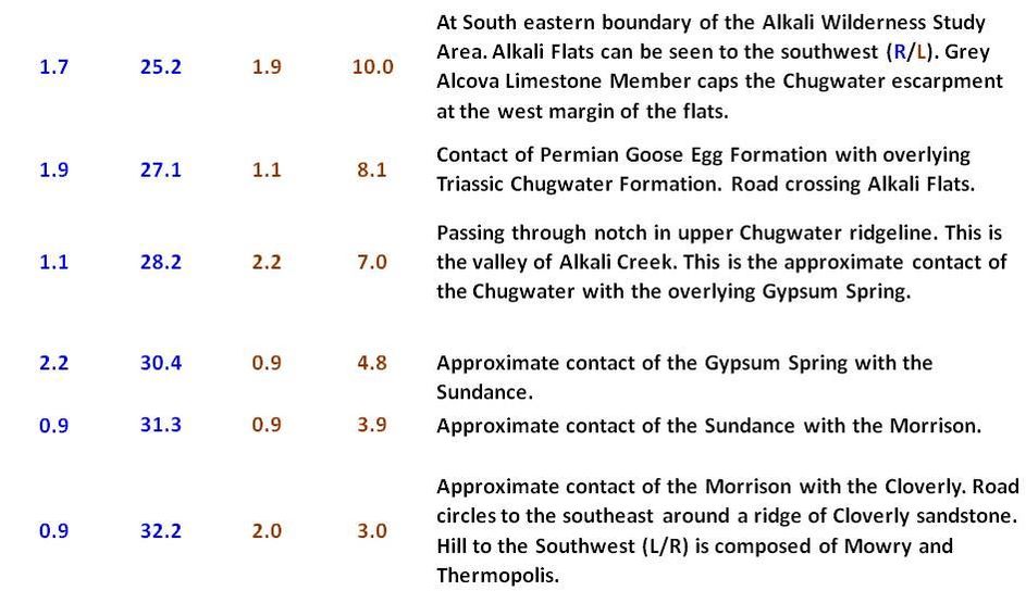
What follows is a geologic roadlog for the 35-mile route along the Red Gulch Alkali Backcountry Byway. The mileage for each section is posted to the left with blue values for southward travel and brown for northward travel. The description for each increment is on the right. Viewing orientations are reported as compass directions with a parenthetic colored “L/R” depending on the direction the byway is traversed. You do not need 4WD for this non-paved road, but conditions must be dry. May to October is the best time to visit.
Geologic map of Red Gulch Alkali Backcountry Byway road log. Red Gulch Dinosaur Tracksite: red star; Trapper Canyon Tar Sand Site: blue star; Medicine Lodge Archaeological Site: green star.
Image: Love, J.D., Christiansen, A.C., and Earle, J.L., 1978, Preliminary geologic map of the Sheridan 1 degree x 2 degree quadrangle, northern Wyoming: U.S. Geological Survey, Open-File Report OF-78-456, scale 1:250,000; Explore this Publication in the NGMDB
Image: Love, J.D., Christiansen, A.C., and Earle, J.L., 1978, Preliminary geologic map of the Sheridan 1 degree x 2 degree quadrangle, northern Wyoming: U.S. Geological Survey, Open-File Report OF-78-456, scale 1:250,000; Explore this Publication in the NGMDB
Roadlog Red Gulch Alkali Backcountry Byway
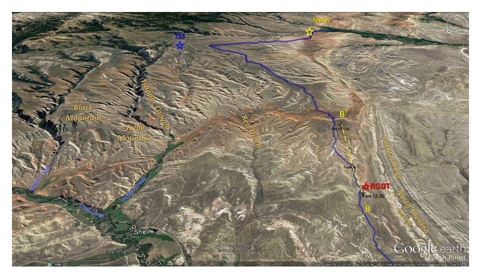
Southeast aerial view of roadlog route (blue line). RGDT: Red Gulch Dinosaur Tracksite (red star); MLAC: Medicine Lodge Archeological Site (yellow star); TSS: Tar Sand Site (blue Star); black dry hole symbols: location of wildcat wells tested for oil and gas. Subsurface log cross section B=B’ location shown by yellow dashed line.
Image: Google Earth
Image: Google Earth
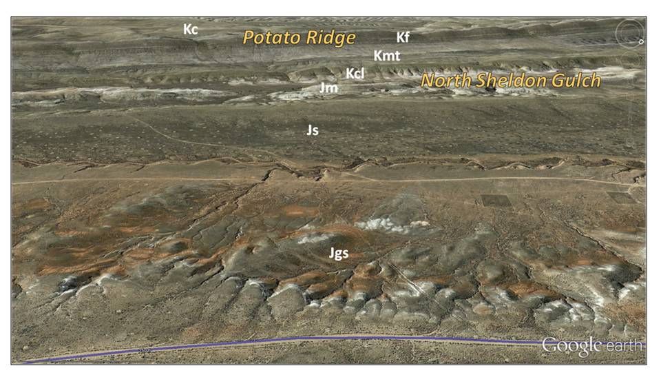
Aerial view to west of Red Gulch Road (blue line) of southwest dipping Mesozoic units on Potato Ridge Bench and in North Sheldon Gulch. Ant hill colonies of the Western Harvester Ant create the spot pattern on the Sundance Formation in the middle distance of image. Geologic notation: Kc: Cretaceous Cody Fm., Kf: Cretaceous Frontier Fm., Kmt: Cretaceous Mowry and Thermopolis Fms., Kcl: Cretaceous Cloverly Fm., Jm Jurassic Morrison Fm., Js: Jurassic Sundance Fm., Jgs: Jurassic Gypsum Spring Fm.
Image: Google Earth
Image: Google Earth
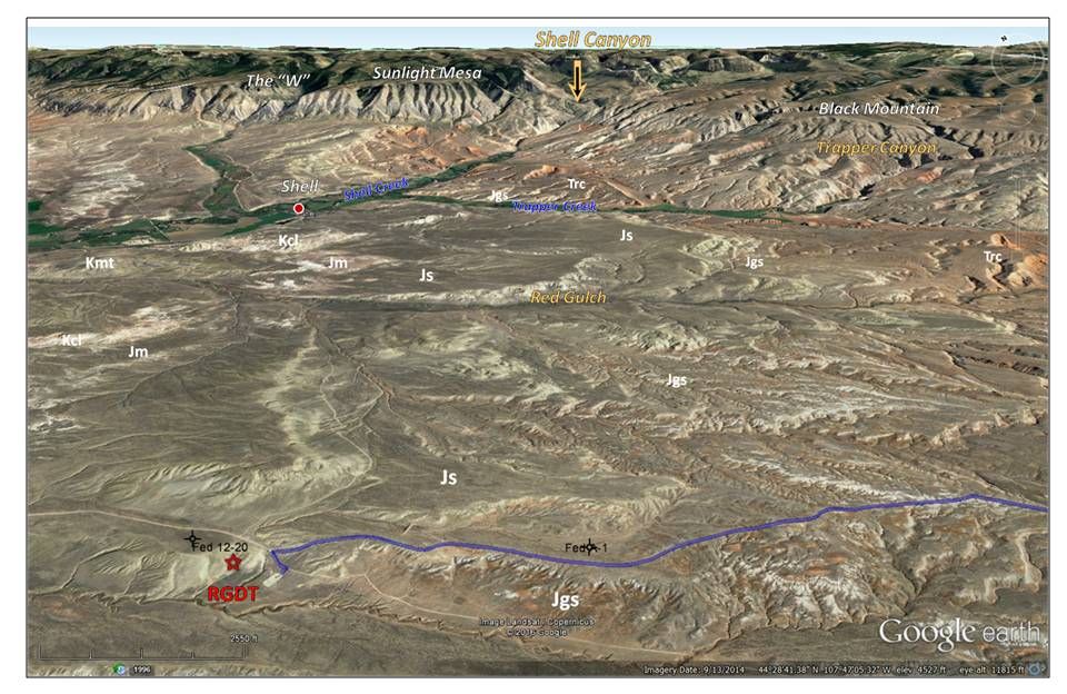
Aerial view to east of Red Gulch Road (blue line) of southwest dipping Mesozoic units on Potato Ridge Bench. Note large increase in dip along the Bighorn Mountain Front at Shell Canyon. The Paleozoic Mississippian Madison and Bighorn Formations triangular-shaped flatirons due to stream erosion of beds elevated by large “blind” thrust fault. The “W” is an example of this feature. These are the units Darton called “the great limestone escarpment.” RGDT: Red Gulch Dinosaur Tracksite. Geologic Notation: Kmt: Cretaceous Mowry – Thermopolis Fms., Kcl: Cloverly Fm., Jm: Jurassic Morrison Fm., Js: Jurassic Sundance Fm., Jgs: Jurassic Gypsum Spring Fm., Trc: Triassic Chugwater Fm., Mm-Obh: Mississippian Madison and Ordovician Bighorn Fms.
Image: Google Earth
Image: Google Earth
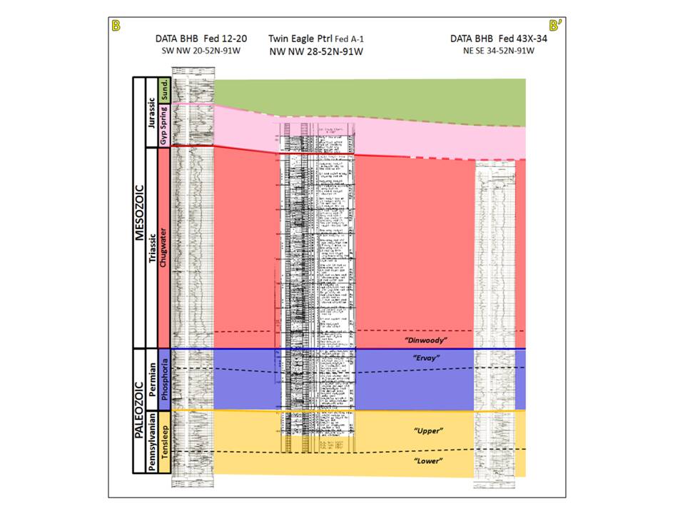
Subsurface log stratigraphic cross section with petroleum industry nomenclature. The Dinwoody Formation here consists of red silt and shale with anhydrite, and is indistinguishable from the overlying Chugwater Formation. The Phosphoria here is mostly Goose Egg red beds with the upper unit consisting of “Ervay” carbonate. Reservoir rocks had oil stain but found no commercial production. The lack of production is maybe due to the flushing of the structures by groundwater flow that is recharged on the nearby flanks of the Bighorn Mountains.
Image: Logs from the Wyoming Oil and Gas Conservation Commission website. http://wogcc.state.wy.us/
Image: Logs from the Wyoming Oil and Gas Conservation Commission website. http://wogcc.state.wy.us/
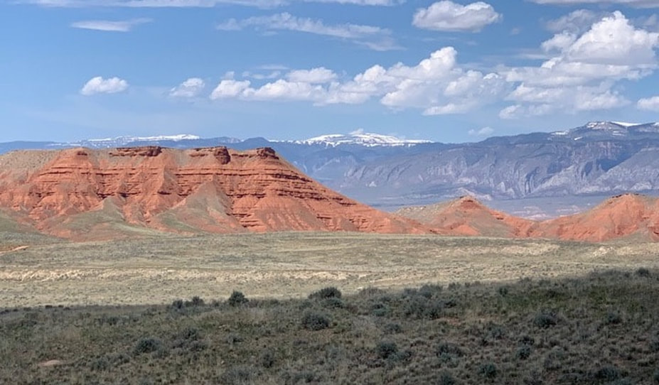
The “Red Wall” exposure of Chugwater red beds with Bighorn Mountains in background.
Image by Mark Fisher
Image by Mark Fisher
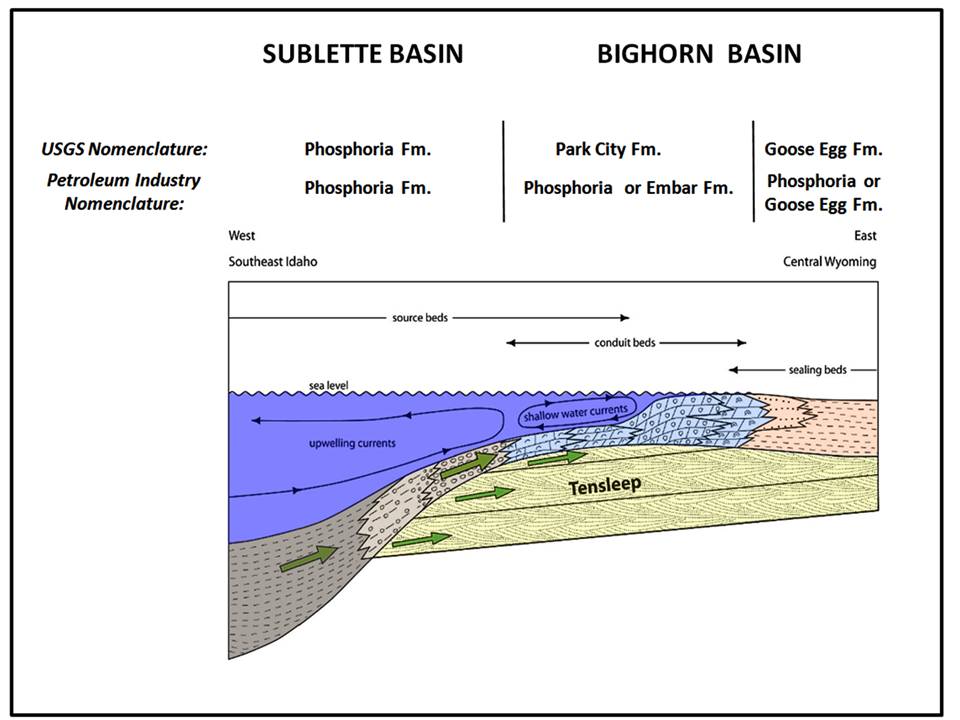
Cross section model of the Permian Rock Complex of the Bighorn Basin area showing formation nomenclature. Hydrocarbons were generated and began to migrate from the Sublette Basin onto the Wyoming Shelf about 160 million years ago. Both the Phosphoria/Park City and Tensleep acted as carrier beds (green arrows). The gas and oil were originally held in stratigraphic traps until structural traps were created by the Laramide tectonism. The hydrocarbons remigrated into the structural traps present today. Groundwater movement added a final adjustment of the hydrocarbon columns, particularly to the fields in the northeastern part of Bighorn County (e.g. Frannie, Sage Creek, and North Deaver). Cottonwood Creek Field is the only stratigraphic accumulation known in the Bighorn Basin. The complex is located about 8 miles south of the Big Horn – Washakie County line in Townships 47-48 North, Ranges 90-92 West. The Trapper Canyon Tar Sand Deposit is an exhumed example of one of these early stratigraphic traps (see: http://www.wsgs.wyo.gov/products/wsgs-1985-ri-30.pdf).
Image: After Yin et al., 2011, Tensleep TZ/ROZ Study, Bighorn Basin: A Revolutionary Concept on Oil Recovery: UW EORI CO2 Conference, Slide #25 (After Stone, 1967) https://www.uwyo.edu/eori/_files/co2conference11/yin%20-%20rozstudy.pdf
Image: After Yin et al., 2011, Tensleep TZ/ROZ Study, Bighorn Basin: A Revolutionary Concept on Oil Recovery: UW EORI CO2 Conference, Slide #25 (After Stone, 1967) https://www.uwyo.edu/eori/_files/co2conference11/yin%20-%20rozstudy.pdf
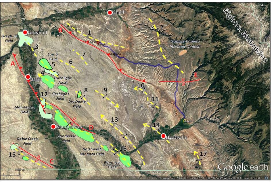
Aerial view of Laramide generated folds and faults in the Red Gulch Alkali Backcountry Byway area. Byway is shown by solid blue line. Oil fields are indicated with dominant producing reservoirs shown by the shades of green: Light green: Cretaceous reservoirs, Dark green: Permian Phosphoria-Pennsylvanian Tensleep reservoirs. Trapper Canyon Tar Sand Deposit is indicated by tan shape. Folds: 1. Cherry Anticline; 2. Black Mountain Anticline; 3. Greybull Anticline; 4. Torchlight Anticline; 5. Lamb Anticline; 6. East Lamb Anticline; 7. Howard Gulch Anticline; 8. Dry Dome; 9. Republic Dome; 10. Mercer Anticline; 11. South Mercer Anticline; 12. Manderson Anticline; 13. Paintrock Anticline; 14. Hyattville Anticline; 15. Dobie Creek Anticline; 16. Bonanza Anticline; 17. Zeisman Dome. Faults: A. Rio Thrust; B. Potato Ridge Thrust; C. Dobie Creek Normal Fault; D. Manderson Normal Fault; E. Alkali Creek Normal Fault. The red triangles on thrust faults point in the direction of dip of the fault plane surface, opposite of the direction of displacement. The displacement on normal faults is indicated by “U” for up and “D” for down.
Image: Google Earth; Structural and Production information: Ver Ploeg, A.J. and De Bruin, R.H., 1985, Trapper Canyon Tar Sand Deposit, Big Horn County, Wyoming: An Exhumed Stratigraphic Oil Trap: The Geologic Survey of Wyoming Report of Investigations No. 30, Fig. 21, p. 27. http://www.wsgs.wyo.gov/products/wsgs-1985-ri-30.pdf
Image: Google Earth; Structural and Production information: Ver Ploeg, A.J. and De Bruin, R.H., 1985, Trapper Canyon Tar Sand Deposit, Big Horn County, Wyoming: An Exhumed Stratigraphic Oil Trap: The Geologic Survey of Wyoming Report of Investigations No. 30, Fig. 21, p. 27. http://www.wsgs.wyo.gov/products/wsgs-1985-ri-30.pdf
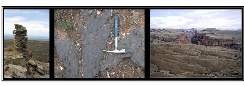
Left: Rock cairn (aka “sheepherder monument”) marking the intersection of Red Gulch (BLM 1109) and Alkali (Co. 111) roads. Center: Trapper Canyon Tar Sand Deposit. Right: Trapper Creek Wilderness Study Area.
Images: Left:http://www.dot.state.wy.us/files/live/sites/wydot/files/shared/Planning/Back%20Country%20Adventure%20on%20Wyoming's%20Scenic%20Backways.pdf; Center: Yin et al., 2011, Feasibility Study of Tensleep ROZ Potential, Bighorn Basin, EORI Technical Advisory Board Presentation, Slide 17, https://www.uwyo.edu/eori/_files/eortab_jan11/yin_2011-tab.pdf; Right: BLM
Images: Left:http://www.dot.state.wy.us/files/live/sites/wydot/files/shared/Planning/Back%20Country%20Adventure%20on%20Wyoming's%20Scenic%20Backways.pdf; Center: Yin et al., 2011, Feasibility Study of Tensleep ROZ Potential, Bighorn Basin, EORI Technical Advisory Board Presentation, Slide 17, https://www.uwyo.edu/eori/_files/eortab_jan11/yin_2011-tab.pdf; Right: BLM
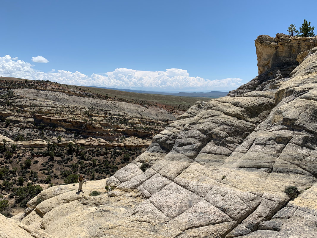
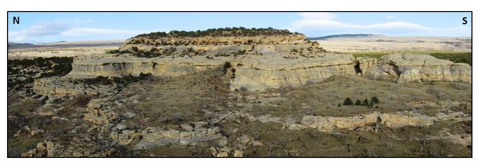
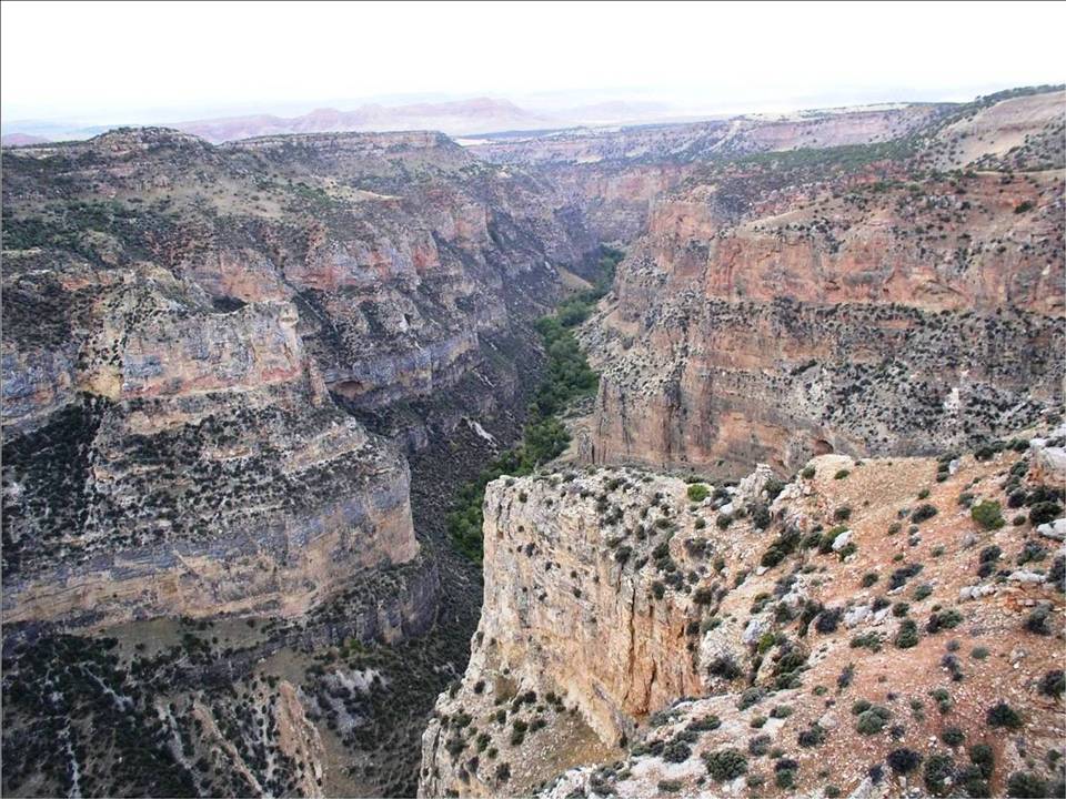
Tensleep Sandstone in Alkali Creek Wilderness Study Area with large scale eolian (wind-blown) cross bedding. Note the vertical fractures.
Image by Mark Fisher
Image by Mark Fisher
Close-up image of Alkali Creek Tensleep Formation ancient dune deposit.
Image: After Ciftci, B.N., 2001, Outcrop-based 3-D Modeling of the Tensleep Sandstone at Alkali Creek, Bighorn Basin, Wyoming: M.S. Thesis, Colorado School of Mines, Fig. 4.48A, p. 173. https://dspace.library.colostate.edu/handle/11124/170531
Image: After Ciftci, B.N., 2001, Outcrop-based 3-D Modeling of the Tensleep Sandstone at Alkali Creek, Bighorn Basin, Wyoming: M.S. Thesis, Colorado School of Mines, Fig. 4.48A, p. 173. https://dspace.library.colostate.edu/handle/11124/170531
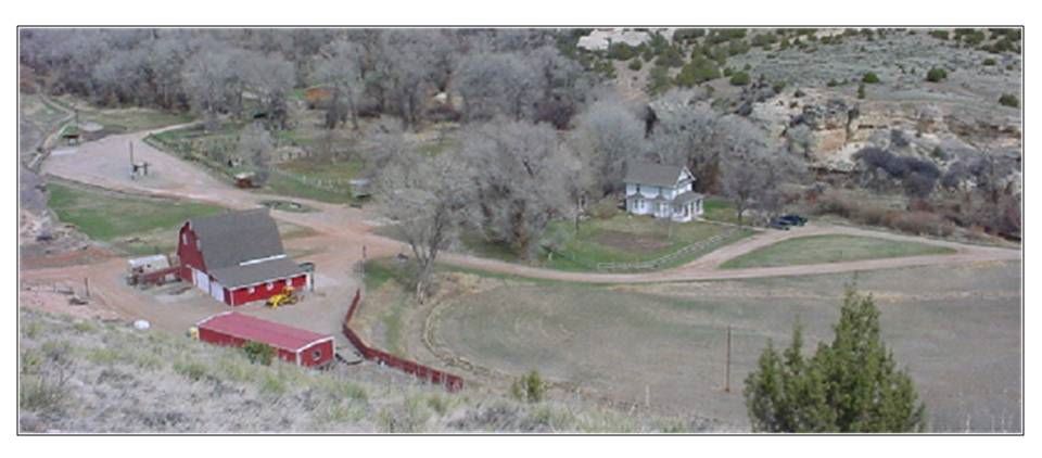
Taylor Ranch at Medicine Lodge Archaeological Site.
Image: Wyoming State Parks
Image: Wyoming State Parks
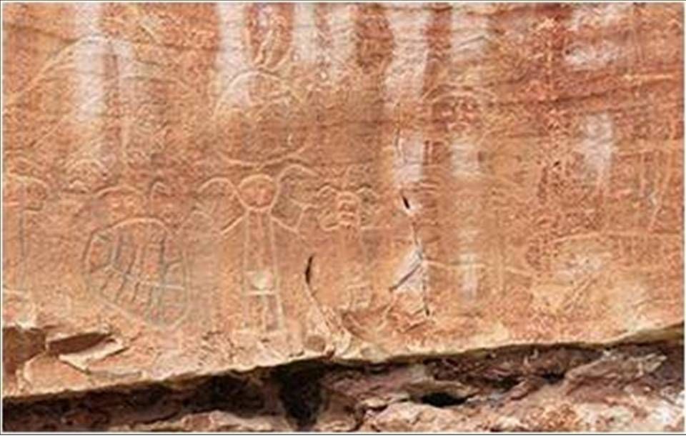
Medicine Lodge Archaeological Site rock art.
Image: http://www.wyohistory.org/encyclopedia/medicine-lodge
Image: http://www.wyohistory.org/encyclopedia/medicine-lodge
Medicine Lodge Tensleep outcrop site.
Image: Finn, M., 2009, Medicine Lodge Tensleep
Image: Finn, M., 2009, Medicine Lodge Tensleep
Medicine Lodge Wilderness Study Area.
Image: BLM
Image: BLM
The Red Gulch Alkali Backcountry Byway is a route of exquisite beauty and blissful solitude. The Wyoming Department of Transportation description perfectly captures this adventure.
“The Red Gulch/Alkali Scenic Backcountry contains more old sheepherder monuments than modern highway signs, and more dinosaur tracks than modern tire tracks.”
“The Red Gulch/Alkali Scenic Backcountry contains more old sheepherder monuments than modern highway signs, and more dinosaur tracks than modern tire tracks.”
Trapper Canyon Tar Sand Deposit (optional side trip)
The Trapper Canyon Tar Sand Deposit is an outcrop example of a stratigraphic oil trap developed in the Tensleep Sandstone. Stratigraphic trapping of oil in the Tensleep and its equivalent the Minnelusa is common in the Powder River Basin, east of the Big Horn Mountains, but stratigraphic traps are rare in the Tensleep in the Bighorn Basin. This accumulation occurs at two topographic hills informally referred to as Deposit A and B. The accumulation at Deposit A is larger and may contain the equivalent of 1 to 2 million barrels of oil. A stratigraphic hydrocarbon accumulation within the Tensleep Formation can form by changes in the porosity and permeability of the sandstone (intraformational), or by erosional channels cutting down into the Tensleep filled with impermeable Phosphoria sediments that create a barrier to oil migration. It can also be a combination of these two factors. The oil trap at nearby Bonanza Field has both these stratigraphic factors and a structural anticline. The Medicine Lodge outcrop near Hyattville has an impermeable Phosphoria fluvial channel overlying the eroded upper surface of the Tensleep Formation.
Intraformational change is believed to be the oil trapping mechanism at the Trapper Canyon outcrop. The evidence for an intraformational stratigraphic trap at Trapper Canyon is: 1) the lack of a structural closure like an anticline or fault, 2) isolation of the oil accumulation to an interior sand in the Tensleep, and 3) the presence of non-oil charged laterally equivalent sands to the tar accumulation. This tar sand deposit displays the kind of stratigraphic trap in the Tensleep Formation that held oil for up to 90 million years, until the Laramide Orogeny (mountain building event 75-65 million years ago) created the anticlinal traps throughout the Bighorn Basin and Wyoming. The stratigraphically held oil began to re-migrate into these structures with the onset of this tectonic event.
Intraformational change is believed to be the oil trapping mechanism at the Trapper Canyon outcrop. The evidence for an intraformational stratigraphic trap at Trapper Canyon is: 1) the lack of a structural closure like an anticline or fault, 2) isolation of the oil accumulation to an interior sand in the Tensleep, and 3) the presence of non-oil charged laterally equivalent sands to the tar accumulation. This tar sand deposit displays the kind of stratigraphic trap in the Tensleep Formation that held oil for up to 90 million years, until the Laramide Orogeny (mountain building event 75-65 million years ago) created the anticlinal traps throughout the Bighorn Basin and Wyoming. The stratigraphically held oil began to re-migrate into these structures with the onset of this tectonic event.
Directions to Trapper Canyon Tar Sands
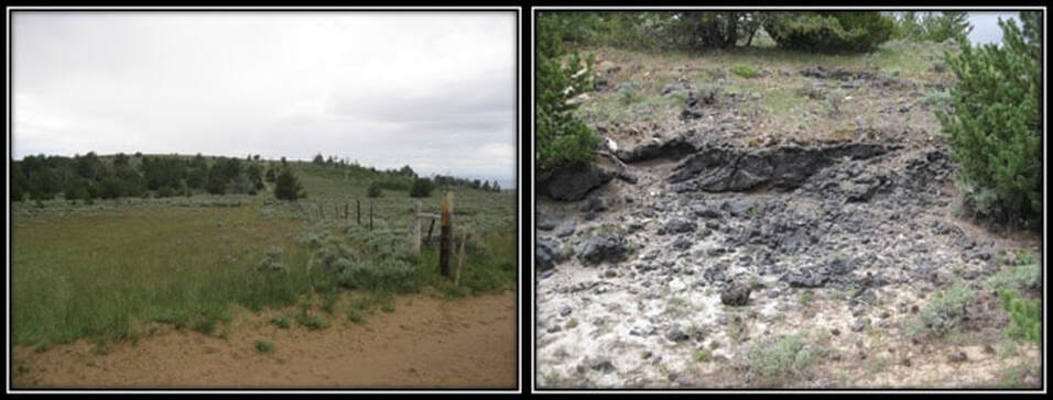
The tar sandstone and the road to it are on BLM land and open to the public. This side trip does not require 4WD, but does require a vehicle with good ground clearance. On outcrop, the tar sandstone is only about 5 to 10 feet thick and not well exposed. You can easily find it, but don't expect it to jump out at you. Look for the tar sand on a mostly covered slope immediately below a prominent ten foot thick, white to buff colored sandstone that forms a resistant ledge/cliff at the top of the Tensleep. The surface of the tar sand is grey. On fresh surfaces, the tar sand is black and smells of oil. There are a couple of small pits dug into the tar sand on the uphill or east side of Deposit A that provide the best exposures.
Coming from Greybull and Shell on the Red Gulch Road (BLM 1109), turn left (northeast) on Alkali Road, 0.4 miles small knob on right is Tensleep Sandstone, road is on gentle grass covered Amsden Formation in upper reaches of Webber Canyon drainage, 0.8 miles cross cattle guard, 1.4 miles cattle corral on left with unmarked two-track road, 1.7 miles turn left on two-track road (1114), 1.9 miles junction with two-track road coming in from left, continue straight, 2.4 miles outcrop of Tensleep sandstone on right, reach fence line and gate, park on left just before fence and gate. Walk west or slightly downhill on two-track road that parallels fence line toward slight knob or hill (Deposit A), ~0.05 miles cross fence at gate, ~0.25 miles small sandstone outcrop in the road near top of knoll/hill, do not continue to top of hill, but take a left and walk parallel to top of ridge, ~0.4 miles reach small pits with tar sand. You can follow this tar sand along strike around the edge of this hill in a southwest direction. The tar sand is just below the prominent buff colored sandstone.
Too many people erroneously think oil accumulations in the subsurface are in caverns or pools of oil. Samples of this oil saturated sandstone provide a good example of what a conventional oil reservoir looks like with the oil located in the pore spaces between the sand grains. Although similar in appearance, oil producing Tensleep Sandstone in the basin is stained brown with less grey and less black than this tar sandstone.
Left: West view of hill (Deposit A) with tar sand outcrops in area with trees
Right: Outcrop of Tensleep tar sands on side of hill
Images by Mark Fisher
Right: Outcrop of Tensleep tar sands on side of hill
Images by Mark Fisher
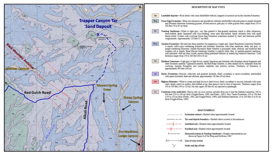
Geologic map and cross section of the Trapper Canyon Tar Sand Deposit area. Red Gulch Alkali Backcountry Byway: solid blue line. Side trip to tar sand deposit: dashed blue line (about 2 miles). Tar sands are located in sections 32 & 33, T52N R89W.
Images: After Ver Ploeg, A.J., and De Bruin, R.H., 2013, Geologic map of the Bush Butte quadrangle, Big Horn County, Wyoming: Wyoming State Geological Survey Map Series 99, 1 sheet, scale 1:24,000. http://sales.wsgs.wyo.gov/geologic-map-of-the-bush-butte-quadrangle-big-horn-county-wyoming/
Images: After Ver Ploeg, A.J., and De Bruin, R.H., 2013, Geologic map of the Bush Butte quadrangle, Big Horn County, Wyoming: Wyoming State Geological Survey Map Series 99, 1 sheet, scale 1:24,000. http://sales.wsgs.wyo.gov/geologic-map-of-the-bush-butte-quadrangle-big-horn-county-wyoming/
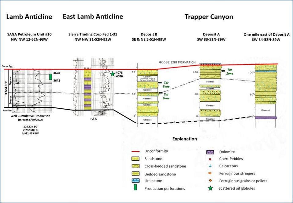
Cross section of Trapper Canyon area outcrop descriptions and subsurface porosity logs of the Tensleep Formation from nearby anticlines. The Upper Tensleep productive zone at Lamb Field is correlative to the show horizon at East Lamb Anticline and tar zones at Trapper Canyon. Note that the hydrocarbon zone lies beneath and above cemented sandstone beds (tight units with low porosity and permeability) in the outcrop sections and on the subsurface porosity logs.
Image: Logs: Wyoming Oil and Gas Conservation Commission, http://wogcc.state.wy.us/ ; Outcrop Description: After Ver Ploeg, A.J., and De Bruin, R.H., 1985, Trapper Canyon Tar Sand Deposit, Big Horn County, Wyoming: An Exhumed Stratigraphic Oil Trap: Wyoming State Geological Survey Report of Investigations No. 30, Fig. 6, p. 9, http://sales.wsgs.wyo.gov/trapper-canyon-tar-sand-deposit-big-horn-county-wyoming-an-exhumed-stratigraphic-oil-trap/
Image: Logs: Wyoming Oil and Gas Conservation Commission, http://wogcc.state.wy.us/ ; Outcrop Description: After Ver Ploeg, A.J., and De Bruin, R.H., 1985, Trapper Canyon Tar Sand Deposit, Big Horn County, Wyoming: An Exhumed Stratigraphic Oil Trap: Wyoming State Geological Survey Report of Investigations No. 30, Fig. 6, p. 9, http://sales.wsgs.wyo.gov/trapper-canyon-tar-sand-deposit-big-horn-county-wyoming-an-exhumed-stratigraphic-oil-trap/

The material on this page is copyrighted
