
Teton Range
Photo by Mark Fisher
Photo by Mark Fisher
Wow Factor (3 out of 5 stars):

Geologist Factor (4 out of 5 stars):

Attraction
Giant Cambrian stromatolites surrounded by early summer alpine flowers and butterflies resembles a modern coral reef. Ancient continental collision created miles of metamorphic gneiss. Enjoy!
Teton Range
The Teton Range is the youngest uplift in the Rocky Mountains. About 6 to 9 million years ago movement on the Teton fault elevated the western block and dropped the eastern valley block to create the Teton Mountains and Jackson Hole. The mountains and valley were sculpted by the Yellowstone ice sheet, but there has not been enough time for the Snake River to carve foothills. The Grand Teton (13,775’ ASL) rises almost 7,000 feet above the valley floor. Mount Moran (12,605’ ASL) dominates the skyline in the northern Tetons. Behind this feature, on the less visited western side of the range, are two amazing geologic treasures.
Teton Range, western Wyoming. Aerial view to west-southwest.
Image: https://eoimages.gsfc.nasa.gov/images/imagerecords/3000/3711/landsat_grand_teton_lrg.jpg.
Image: https://eoimages.gsfc.nasa.gov/images/imagerecords/3000/3711/landsat_grand_teton_lrg.jpg.
Archean Tectonics Of The Northern Tetons
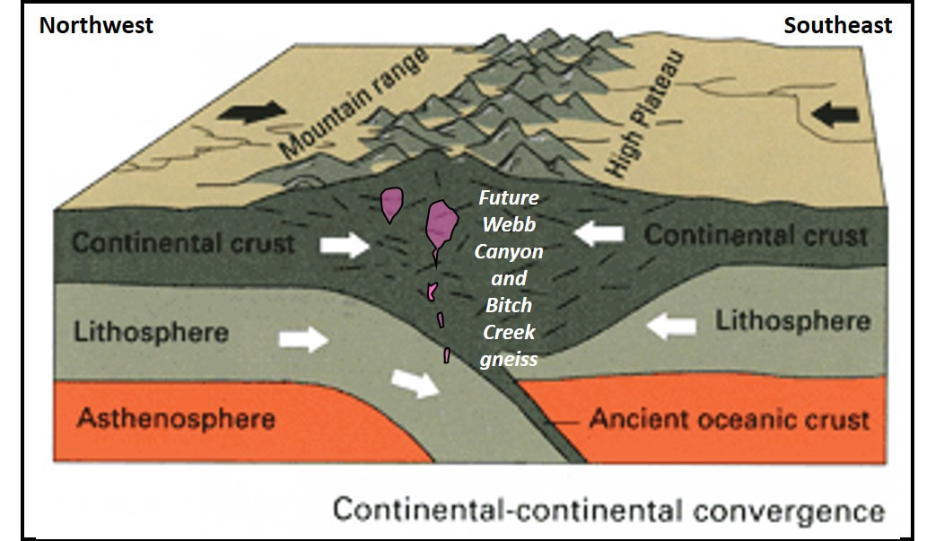
The basement rocks of the Tetons hold evidence of the world’s earliest known continent-continent collision. The clues were found in the Moose Basin region north and west of Mount Moran (Swapp et. al., 2018). The lithologies of the rocks with their high heat and high pressure features along the Moran Deformation Zone are products of that ancient collision. The towering Himalayan-type peaks produced by the Teton collision 2.6 billion years ago were beveled almost flat long before the first Phanerozoic sea moved into Wyoming. Prior to this discovery, the oldest known evidence for continent convergent plate tectonics was the 1.1-billion-year-old Grenville orogen.
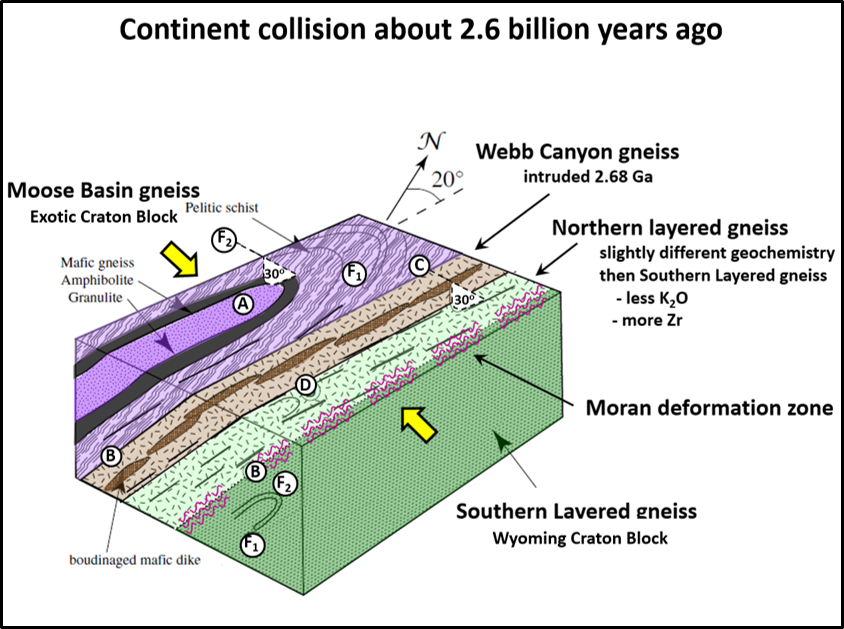
The Neoarchean continent-continent collision of Moose Basin gneiss of the exotic craton block with the Layered gneiss of the Wyoming Craton Block. The Moran Deformation Zone is the product of this collision. Block diagram showing relations among major units in the northern Teton Range. Key features: (A) The Moose Basin gneiss consists of schist and gneiss forming the cores of the antiforms (folds that are convex upward like an umbrella). (B) Contacts between the Moose Basin gneiss and the Webb Canyon gneiss are parallel to the major foliation in the area. (C) Lineation in the Webb Canyon gneiss is parallel to the antiform fold axis in the Moose Basin gneiss. (D) In most areas, the Webb Canyon gneiss shows no folding. Late amphibolite dikes intruded into the rocks have locally boudinaged sausage-shaped structures formed by extension. The yellow arrows show inferred east-west direction of movement during the continent-continent collision. The Moose Basin gneiss attached to the Layered gneiss along the Moran deformation zone that is oriented south-southwest to north-northeast (10 degrees). Dip on the deformation zone is 40 degrees east.
Image: After Swapp, S.M., Frost, C.D., Frost, B.R., and Fitz-Gerald, D.B., 2018, 2.7 Ga high-pressure granulites of the Teton Range: Record of Neoarchean continent collision and exhumation: Geosphere, vol. 14, no. 3, Fig. 4, p. 1037, https://pubs.geoscienceworld.org/gsa/geosphere/article/14/3/1031/530879/2-7-ga-high-pressure-granulites-of-the-teton-range.
Image: After Swapp, S.M., Frost, C.D., Frost, B.R., and Fitz-Gerald, D.B., 2018, 2.7 Ga high-pressure granulites of the Teton Range: Record of Neoarchean continent collision and exhumation: Geosphere, vol. 14, no. 3, Fig. 4, p. 1037, https://pubs.geoscienceworld.org/gsa/geosphere/article/14/3/1031/530879/2-7-ga-high-pressure-granulites-of-the-teton-range.
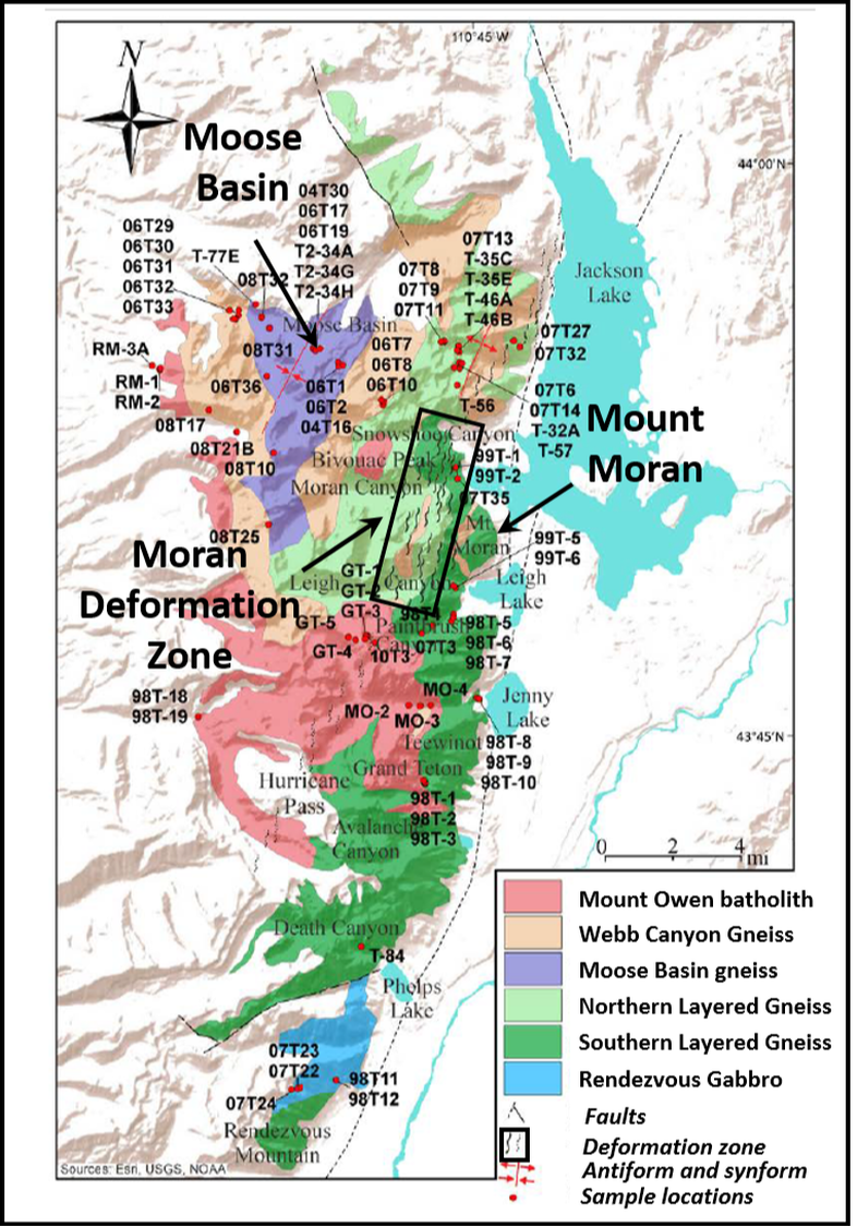
Geologic map of the Archean rocks of the Teton Range. The area of the Moran Deformation Zone is shown by black rectangle. The Archean deformation occurred 2.6 billion years before the Teton Fault that runs north-south along the eastern edge of the Tetons that uplifted the Teton Range and dropped the valley we see today. The location of the Teton Fault is shown by the dotted line near the eastern edge of the Tetons running through Phelps Lake, Jenny Lake, Leigh Lake and Jackson Lake.
Image: After Frost, R.B., Swapp, S.M., Frost, C.D., Begdonas, D.A., and Chamberlain, K.R., 2018, Neoarchean tectonic history of the Teton Range: Record of accretion against the present-day western margin of the Wyoming Province: Geosphere, v. 14, no. 3, Fig. 2, p. 1009; doi: 10.1130/GESO1559.1. https://pubs.geoscienceworld.org/ssa/geosphere/article/14/3/1008/530188
Image: After Frost, R.B., Swapp, S.M., Frost, C.D., Begdonas, D.A., and Chamberlain, K.R., 2018, Neoarchean tectonic history of the Teton Range: Record of accretion against the present-day western margin of the Wyoming Province: Geosphere, v. 14, no. 3, Fig. 2, p. 1009; doi: 10.1130/GESO1559.1. https://pubs.geoscienceworld.org/ssa/geosphere/article/14/3/1008/530188
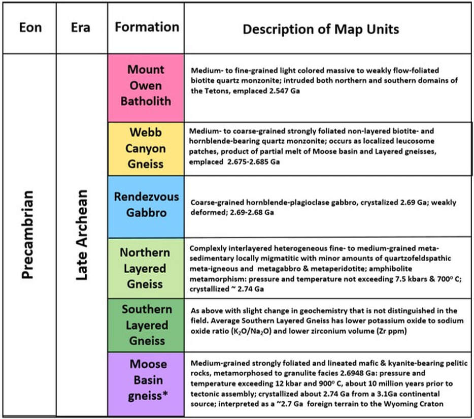
Stratigraphic column of Archean rocks in the Teton Range.
Image: Steele, K.K., 2019, After Frost et. al., 2018, and Swapp et. al., 2018.
Image: Steele, K.K., 2019, After Frost et. al., 2018, and Swapp et. al., 2018.
|

|
Left: Cross sectional model of a continent-continent collision. The labelled orientation is the direction of convergence in the northern Tetons. Right: Tectonic model of western Wyoming Province between 2.68-2.67 Ga Orientation shows the eastward motion of the Moose Basin block and western motion of the Wind River Range magmatic arc.
Image: Left: After https://pubs.usgs.gov/gip/dynamic/understanding.html; Right: After Frost, B.R., Frost, C.D., Cornia, M., Chamberlain, K.R., and Kirkwood, R., 2006, The Teton – Wind River domain: a 2.68–2.67 Ga active margin in the western Wyoming Province: Can. J. Earth Sci. 43, Fig. 13, p. 1507; https://pdfs.semanticscholar.org/23c6/44b2973fd6a684317e1b038072a64016727b.pdf.
Image: Left: After https://pubs.usgs.gov/gip/dynamic/understanding.html; Right: After Frost, B.R., Frost, C.D., Cornia, M., Chamberlain, K.R., and Kirkwood, R., 2006, The Teton – Wind River domain: a 2.68–2.67 Ga active margin in the western Wyoming Province: Can. J. Earth Sci. 43, Fig. 13, p. 1507; https://pdfs.semanticscholar.org/23c6/44b2973fd6a684317e1b038072a64016727b.pdf.
The Archean age rocks in the northern Tetons consist of deformed gneisses that were metamorphosed from both sedimentary and igneous source rocks. They are intruded by light colored (high silica) gneisses and by the younger Mt. Owens quartz monzonite (granites that form the central high Tetons). The southern Tetons lack the intrusions and did not reach as high a grade of metamorphism as the northern domain. The northern rocks consist of four units, the Moose Canyon gneiss, the Layered Gneiss, the Webb Canyon Gneiss and the Bitch Creek Gneiss. The story of these rocks moves the age of known active continental plate convergence about 1.6 billion years further back in time.
The Moose Basin gneiss originated as basinal sediments shed from a 3.1 billion year old island arc (possibly a segment of the Idaho Block). The sediments were buried to a depth of about 28 miles and crystallized about 2.74 billion years ago. They underwent high-pressure, high-temperature granulite facies metamorphism 2.69 billion years ago. Ten million years later they collided with the amphibolite-grade Layered Gneisses of the southern Teton block. Both domains were intruded by the Webb Canyon Gneiss over the next ten million years. The intrusion consisted of partial melts from both blocks. The Wind River Range was the magmatic arc generated by this tectonism.
The Layered Gneiss originated as layered sediments with some interbedded igneous layers deposited in an ocean basin adjacent to the Wyoming craton. Crystallization occurred around 2.7 billion years ago at a depth of about 12.5 miles. The rocks reached amphibolite-grade metamorphism before being attached to the Moose Basin gneiss during the Neoarchean continental collision. Both the Moose Basin gneiss and Layered gneisses had partial melts that generated silica-rich gneiss of the Webb Canyon.
Based on geochemistry, two distinct types of leucogranites (granites with almost no dark minerals) where formed due to their differing manner of melting. The more voluminous Webb Canyon Gneiss occurs as large, tabular exposures and the Bitch Creek Gneiss occurs as small sills, dikes and plutons. They were emplaced in multiple phases shortly after the collision.
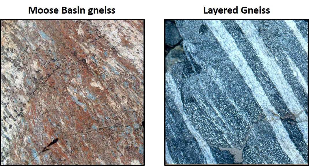

The main rock units in the northern Teton area. The Moose Basin gneiss shows kyanite crystals in a pelitic texture (metamorphosed fine grain sedimentary rock) and represents the foreign terrane block. The Layered Gneiss shows the characteristic alternating dark/light banding that is prominent throughout the range. The Layered Gneiss is a part of the Wyoming craton block. The Webb Canyon Gneiss shows the distinctive high silica, light color. The unit is a product of the collision.
Image: Top Left: After Swapp, S.M., Frost, C.D., Frost, B.R., and Fitz-Gerald, D.B., 2018, 2.7 Ga high-pressure granulites of the Teton Range: Record of Neoarchean continent collision and exhumation: Geosphere, vol. 14, no. 3, Fig. 3A, p. 1034, https://pubs.geoscienceworld.org/gsa/geosphere/article/14/3/1031/530879/2-7-ga-high-pressure-granulites-of-the-teton-range; Top Right: After https://www.discovergrandteton.org/teton-geology/teton-rocks/; Bottom: Middle: After Frost, C.D., Swapp, S.M., Frost, B.R., Finley-Blasi, L., and Fitz-Gerald, D.B., 2016, Leucogranites of the Teton Range, Wyoming: a record of Archean collisional orogeny, Geochimica et Cosmochimica Acta, vol. 185, p 528-549, https://www.sciencedirect.com/science/article/abs/pii/S0016703715007097.
Image: Top Left: After Swapp, S.M., Frost, C.D., Frost, B.R., and Fitz-Gerald, D.B., 2018, 2.7 Ga high-pressure granulites of the Teton Range: Record of Neoarchean continent collision and exhumation: Geosphere, vol. 14, no. 3, Fig. 3A, p. 1034, https://pubs.geoscienceworld.org/gsa/geosphere/article/14/3/1031/530879/2-7-ga-high-pressure-granulites-of-the-teton-range; Top Right: After https://www.discovergrandteton.org/teton-geology/teton-rocks/; Bottom: Middle: After Frost, C.D., Swapp, S.M., Frost, B.R., Finley-Blasi, L., and Fitz-Gerald, D.B., 2016, Leucogranites of the Teton Range, Wyoming: a record of Archean collisional orogeny, Geochimica et Cosmochimica Acta, vol. 185, p 528-549, https://www.sciencedirect.com/science/article/abs/pii/S0016703715007097.
Cambrian Seaway Algal Buildups In The Northern Tetons
As the Precambrian ended, plate tectonics broke apart the Earth’s single continent Rodinia. The largest bit, Gondwana, drifted south to low latitudes in the southern hemisphere. Laurentia, the second largest piece, containing the Wyoming Craton, moved northward closer to the equator. The continent was rotated 90 degrees clockwise, relative to its present location. The western edge of Wyoming (northern in the Cambrian) was a passive margin far from another plate boundary. The spreading center was located off the east coast (Cambrian south) of America between Gondwana and Laurentia.
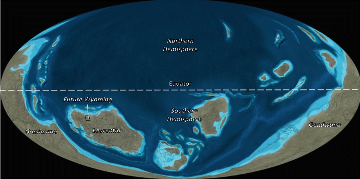
Post-Rodinia world at the beginning of the Cambrian Period about 540 million years ago. Wyoming is located on Laurentia in the lower left of the image.
Image: After Blakey, R.C. and Ranney, W.D., 2018, Ancient Landscapes of Western North America: A Geologic History with Paleogeographic Maps (Kindle Edition) , Fig. 4.4, Location 1195.
Image: After Blakey, R.C. and Ranney, W.D., 2018, Ancient Landscapes of Western North America: A Geologic History with Paleogeographic Maps (Kindle Edition) , Fig. 4.4, Location 1195.

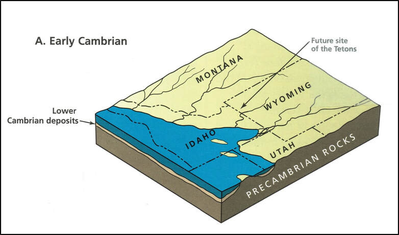
Western North America in the Early Cambrian. Wyoming was above sea level during this time and no stratigraphic record exists within the state for the first 20 to 30 million years of the Phanerozoic. Wyoming is outlined by black line.
Image: After Blakey, R. and Colorado Plateau Geosystems, Inc., No Date, Paleogeography of Western North America: 540_Ear_Cam, CD for computer.
Image: After Blakey, R. and Colorado Plateau Geosystems, Inc., No Date, Paleogeography of Western North America: 540_Ear_Cam, CD for computer.
Block diagram showing the Early Cambrian shoreline of the transgression (flooding) sea.
Image: Love, J.D., Reed, J.C., Jr., and Pierce, K.L., 2003, Creation of the Teton Landscape: The Geologic Story of Grand Teton National Park, 2nd Edition: Fig. 34A, p. 43. https://www.gutenberg.org/files/52838/52838-h/52838-h.htm#c37
Image: Love, J.D., Reed, J.C., Jr., and Pierce, K.L., 2003, Creation of the Teton Landscape: The Geologic Story of Grand Teton National Park, 2nd Edition: Fig. 34A, p. 43. https://www.gutenberg.org/files/52838/52838-h/52838-h.htm#c37
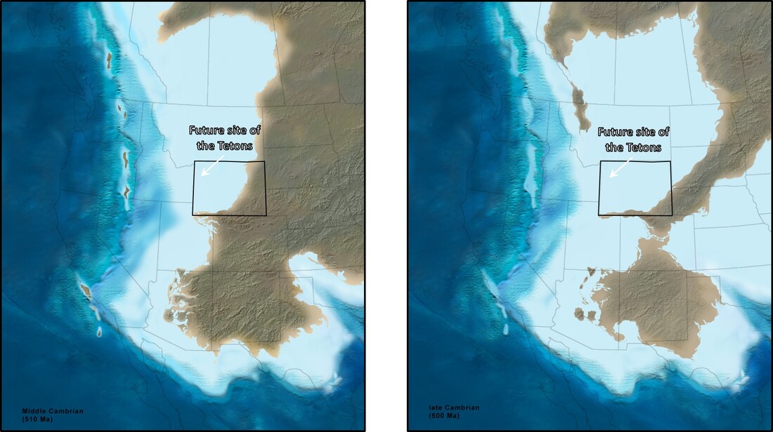
The Cambrian seaway transgression through time. Left: The Flathead Sandstone and the Gros Ventre Group were deposited during the Middle Cambrian. Right: The Gallatin Group was deposited in the Late Cambrian.
Image: After Blakey, R. and Colorado Plateau Geosystems, Inc., No Date, Paleogeography of Western North America: 510_Mid_Cam and 500_Late_Cam, CD for computer.
Image: After Blakey, R. and Colorado Plateau Geosystems, Inc., No Date, Paleogeography of Western North America: 510_Mid_Cam and 500_Late_Cam, CD for computer.
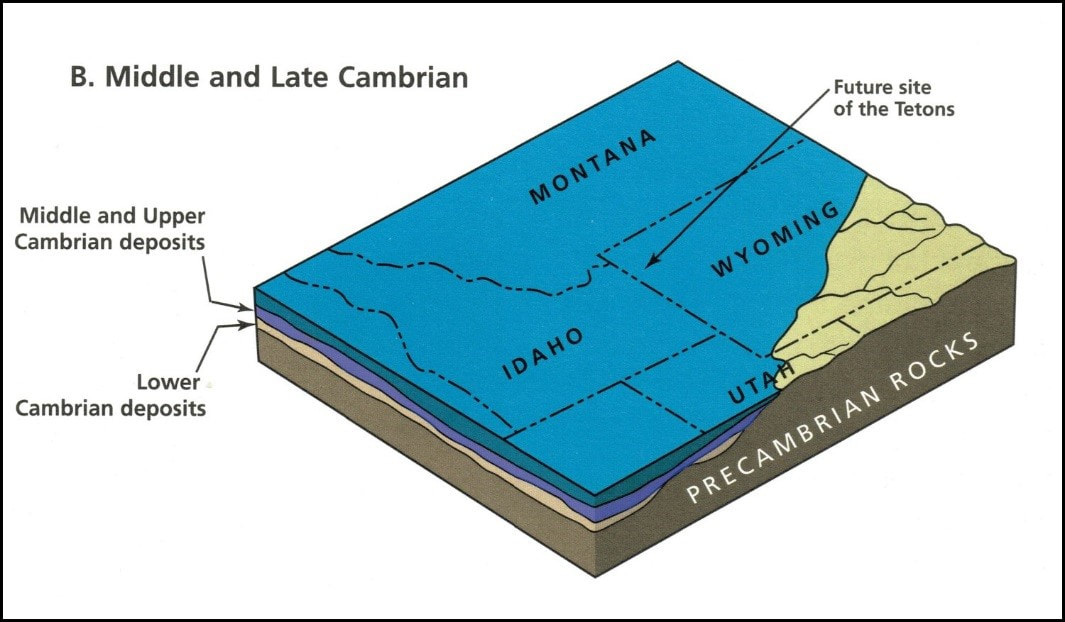
Block Diagram showing the Middle and Late Cambrian shoreline advance of the transgressing sea. This time period holds the first Phanerozoic rocks deposited in Wyoming (purple layer onlapping the tan layer). As the sandstone facies was deposited near the shoreface, carbonate units were being deposited in the shallow marine water and shales in the deeper basin.
Image: After Love, J.D., Reed, J.C., Jr., and Pierce, K.L., 2003, Creation of the Teton Landscape: The Geologic Story of Grand Teton National Park, 2nd Edition: Fig. 34B, p. 43. https://www.gutenberg.org/files/52838/52838-h/52838-h.htm#c37
Image: After Love, J.D., Reed, J.C., Jr., and Pierce, K.L., 2003, Creation of the Teton Landscape: The Geologic Story of Grand Teton National Park, 2nd Edition: Fig. 34B, p. 43. https://www.gutenberg.org/files/52838/52838-h/52838-h.htm#c37

Cambrian stratigraphic column showing position of stromatolitic units in the Death Canyon and Open Door limestones.
Image: After Middleton, L.T., 2001, Middle Cambrian offshore microbialites and shoaling successions, western Wyoming : Implications for regional paleography: Rocky Mountain Geology, Vol. 36, Fig. 2, p. 83.
Image: After Middleton, L.T., 2001, Middle Cambrian offshore microbialites and shoaling successions, western Wyoming : Implications for regional paleography: Rocky Mountain Geology, Vol. 36, Fig. 2, p. 83.
Wyoming was a barren terrane of granite, gneiss and metasedimentary rocks eroded to a relatively flat plain dotted with some granitic hills up to 400 feet. Higher terrane further southeast was related to the Cheyenne Belt and Transcontinental Arch. The landscape was an empty place, void of any flora or fauna. All life was aquatic at the time. The first marine waters reached Wyoming about 520-510 million years ago in the Middle Cambrian depositing the Flathead Sandstone.
The Flathead represents the basal transgressive sand of the Middle Cambrian seaway. The sands range from braided streams (draining the continent), to shoreface and intertidal deposits that are compositionally and texturally mature (rounded quartz grains). The formation is composed of reddish-tan to gray fining-upward, cross-bedded, coarse- to fine-grained sandstones with granules and pebble conglomerates near the base. Thickness averages 165 feet and ranges from 165 to 200 feet in the Teton area depending on Precambrian topography. The Flathead shoreline was oriented north-south. Sand deposits were progressively younger eastward as the sea moved onto the continent.
The overlying Gros Ventre Group consists of three members, the basal Wolsey Shale, the middle Death Canyon Limestone and the upper Park Shale. Combined group thickness averages 605 feet and ranges from 590-785 feet. As the Cambrian sea moved landward, Wolsey mud and fine sand settle from suspension onto the Flathead surface. Carbonate sediments increase upwards as clastic sediments (clay, silt and sand) decrease. The 100-foot unit represents deposition in a shallow, low-energy offshore environment. Hummocky cross beds and scoured basal contacts indicate that occasional storm currents occurred.
The Death Canyon Limestone consists of various fossiliferous carbonate units that contain ooids and peloids. At the top of the 285-foot unit, near the contact with the overlying Park Shale, are microbial mounds (locations shown in image below). The carbonates were deposited in shallow water in a tidally dominated environment of islands, carbonate sand flats and tidal channels. Carbonate production ended as clastics were brought into the area by a regressing sea.
The Park Shale is similar, generally a repeat of Wolsey Shale deposition. As the fossiliferous green shale decreases upward, carbonate content increases. The unit is about 220 feet thick.
The Upper Cambrian Gallatin Group also consists of three units, the Du Noir Limestone at the base, the mid-level Dry Creek Shale, and the Open Door Limestone on top. The Du Noir Limestone was deposited in deeper water conditions. The Dry Creek Shale indicates another influx of clastic sediment that shut down carbonate production. With the return of carbonate in the Open Door Limestone, intertidal sedimentation returned producing additional algal buildups. The Gallatin Group thickness averages 180 feet.
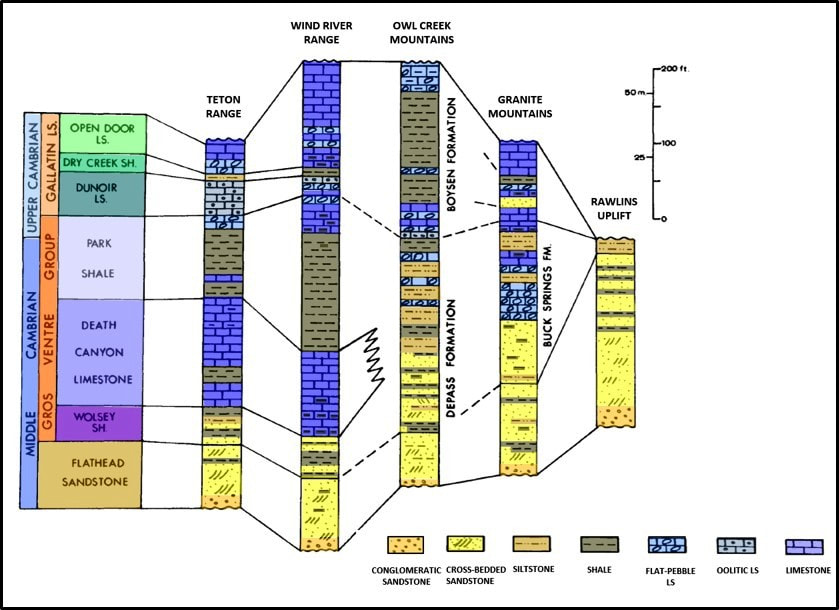
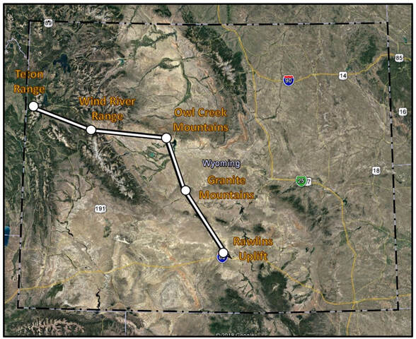
Regional northwest-southeast cross section of Cambrian measured sections showing the transgressive nature of the rocks. The Death Canyon Limestone pinches out in the Owl Creek Mountains and stratigraphic nomenclature changes.
Image: After Middleton, L.T., Steidtmann, J.R., and DeBour, D.A., 1980, Stratigraphy and Depositional Setting of Some Middle and Upper Cambrian Rocks, Wyoming: Wyoming Geological Association 31st Annual Field Conference Guidebook, Stratigraphy of Wyoming, Fig. 2, p. 25; Bottom: Google Earth.
Image: After Middleton, L.T., Steidtmann, J.R., and DeBour, D.A., 1980, Stratigraphy and Depositional Setting of Some Middle and Upper Cambrian Rocks, Wyoming: Wyoming Geological Association 31st Annual Field Conference Guidebook, Stratigraphy of Wyoming, Fig. 2, p. 25; Bottom: Google Earth.
Giant Stromatolites in the Tetons
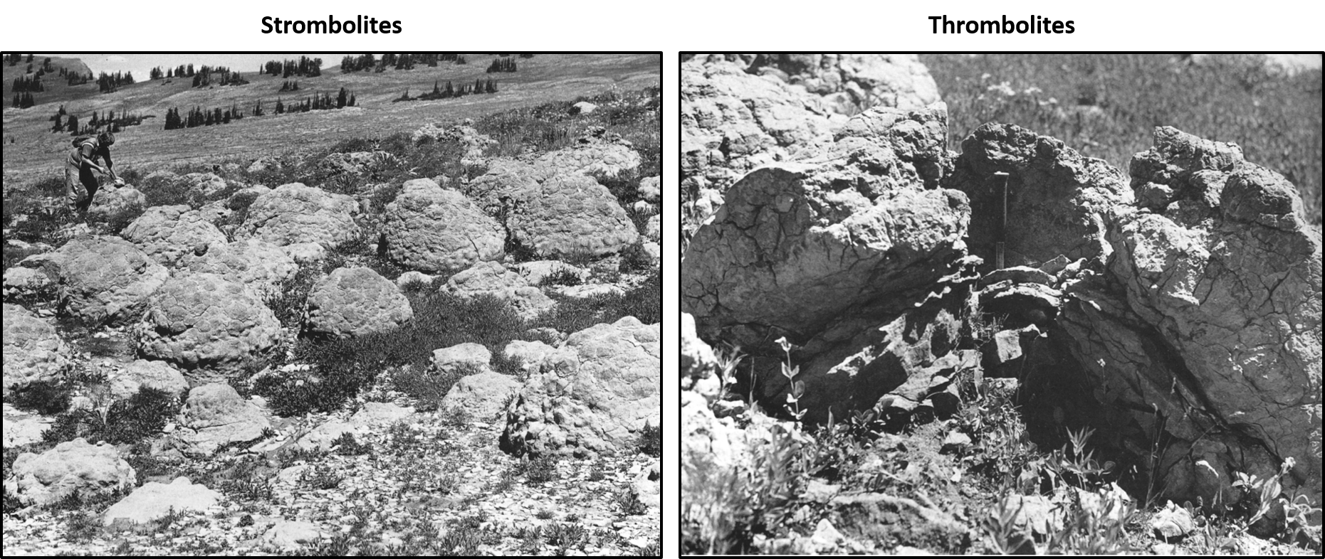
In the area between North and South Leigh Creek, at the contact of the Cambrian Death Canyon Limestone and Cambrian Park Shale, is preserved what was first reported as an “algal reef.” These giant cabbage-head features are stromatolitic and thrombolytic columns.
Stromatolites consist of calcareous mound, columns and sheet-like structures built up of layers of lime-secreting cyanobacteria and trapped sediment. Thrombolites are a clotted accretionary structure formed in shallow water by the trapping, binding, and cementation of sedimentary grains by biofilms of microorganisms, especially cyanobacteria (see The Snowy Range Stromatolites).
Stromatolites consist of calcareous mound, columns and sheet-like structures built up of layers of lime-secreting cyanobacteria and trapped sediment. Thrombolites are a clotted accretionary structure formed in shallow water by the trapping, binding, and cementation of sedimentary grains by biofilms of microorganisms, especially cyanobacteria (see The Snowy Range Stromatolites).
Microbial mounds in the Death Canyon Limestone, Gros Ventre Group on the west side of the Tetons between North and South Leigh Creek.
Image: After Middleton, L.T., 2001, Middle Cambrian offshore microbialites and shoaling successions, western Wyoming: Implications for regional paleography: Rocky Mountain Geology, Vol. 36, Fig. 9, p. 90 and Fig. 8, p. 89.
Image: After Middleton, L.T., 2001, Middle Cambrian offshore microbialites and shoaling successions, western Wyoming: Implications for regional paleography: Rocky Mountain Geology, Vol. 36, Fig. 9, p. 90 and Fig. 8, p. 89.
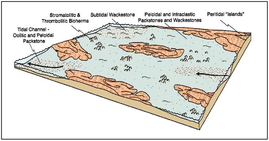
Depositional model for the Cambrian Death Canyon Limestone showing offshore tidally dominate islands, intervening channelized areas, and carbonate sand flats with algal bioherms.
Image: After Middleton, L.T., 2001, Middle Cambrian offshore microbialites and shoaling successions, western Wyoming : Implications for regional paleography: Rocky Mountain Geology, Vol. 36, Fig. 15, p. 95.
Image: After Middleton, L.T., 2001, Middle Cambrian offshore microbialites and shoaling successions, western Wyoming : Implications for regional paleography: Rocky Mountain Geology, Vol. 36, Fig. 15, p. 95.
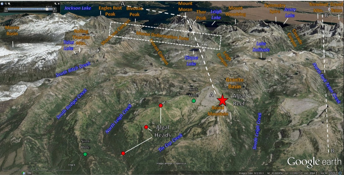
East aerial view of the Teton Range stromatolites. Approximate locations of cross section AA’ and BB’ are shown.
Image: Google Earth
Image: Google Earth

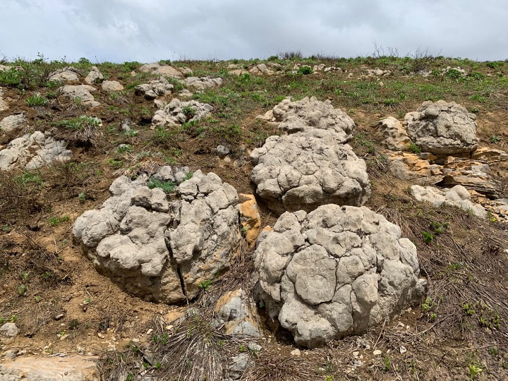
Cambrian stromatolite along Death Canyon Shelf portion of the Teton Crest Trail. View to north with Tetons in background.
Image by Mark Petersen
Image by Mark Petersen
Hike to Cambrian stromatolites on west flank of Tetons

|
|
Top and Bottom left: Cambrian stromatolite bioherm on Green Mountain trail in North Leigh Creek drainage. Bottom right: view of same bioherm from Green Mountain trail at 3.3 miles from trailhead.
Images by Mark Fisher
Images by Mark Fisher
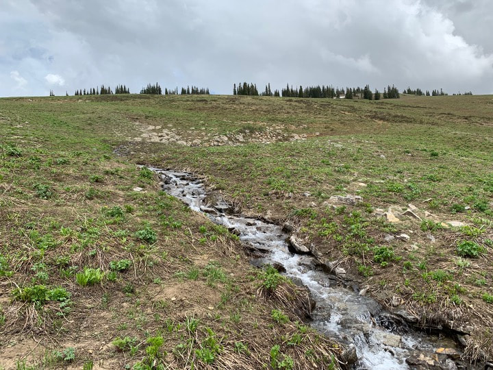
A hike to one of the stromatolite bioherms of about fifty heads in the North Leigh Creek drainage on Green Mountain/Green Lake trail is about 3.3 miles each way and a vertical climb of 1,300 feet. Park at the Green Mountain trailhead where the North Leigh Creek Road crosses the creek and ends in a small loop. Walk about a tenth of a mile on a dirt two-track and ford Tin Cup Creek. Wading shoes and a hiking stick would be helpful for this stream crossing, especially in the spring. Green Mountain/Green Lake trail begins at the stream crossing and climbs slowly through the forest. At 1.3 miles from the car, trail splits into Tin Cup trail to the right and Green Mountain trail to the left. Take left fork up Green Mountain trail. Trail climbs up long switchbacks in large open fields with occasional groves of aspens. At about 3.3 miles from the parking area with a creek and pine trees on your immediate right, the stromatolite bioherm is on left about 100 feet off the trail upslope in an open field. In mid-June when we visited, a spring was issuing from the bioherm area and flowing across the Green Mountain trail. There is another stromatolite bioherm further up the Green Mountain trail that we did not visit, perhaps another mile? (see geologic map below). Please do not take any stromatolites or damage these rocks. Save them for future generations!
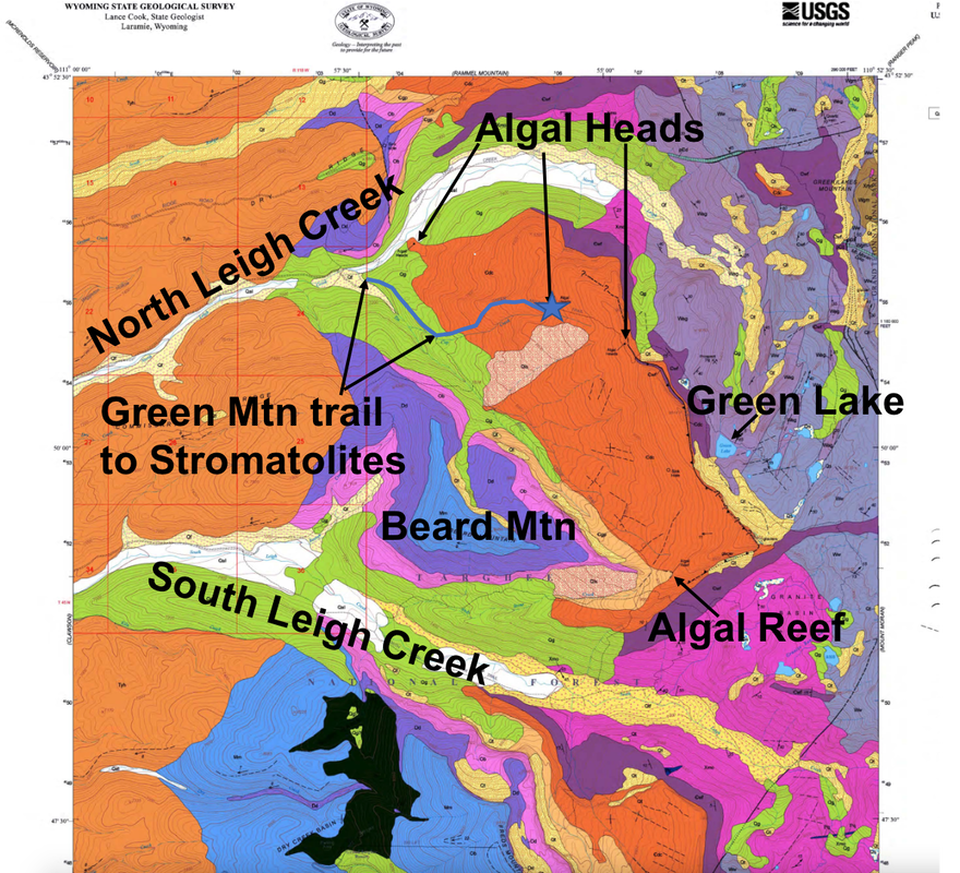
Geologic map showing detailed location of stromatolites (algal heads) in the Cambrian Death Canyon Limestone (Cdc), darker orange. Cambrian Flathead Sandstone and Wolsey Shale (Cwf) dark purple, Archean Gneiss on northeast side of map (Ww, Wgm, Wag) grayish blues and purples, Early Proterozoic Mount Owen Quartz Monzonite on southeast corner of map (Xmo) bright pink, Tertiary Pliocene Huckleberry Ridge Tuff on west side of map (Tyh) light orange, Pleistocene Glacial Deposits (Qg) bright light green. Green Mountain/Green Lake Trail to stromatolite bioherm in blue line and blue star. Scale shown by section blocks of one mile.
Image: Reed, J. C., and J. D. Love, 2001, Geologic Map of the Granite Basin Quadrangle, Teton County, Wyoming, Map LMS-5, https://www.wsgs.wyo.gov/products/wsgs-2001-lms-05.pdf
Image: Reed, J. C., and J. D. Love, 2001, Geologic Map of the Granite Basin Quadrangle, Teton County, Wyoming, Map LMS-5, https://www.wsgs.wyo.gov/products/wsgs-2001-lms-05.pdf
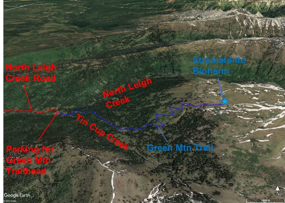
Aerial view of Green Mountain trail to Cambrian stromatolite bioherm.
Image by Google Earth
Image by Google Earth
Driving directions to Green Mountain trailhead on North Leigh Creek from Driggs (15.2 miles): Starting at the only stoplight in downtown Driggs, drive north on Highway 33, 5.7 miles turn right on N500W where highway 33 starts curving to left, 5.9 miles turn right on W5750N (Leigh Road), 6.4 miles turn left on N Baseline Road, 6.6 miles turn right on E6000N, 8.6 miles turn left on North Leigh Creek Road, 9.9 miles Idaho-Wyoming border at cattle guard (no sign), 10.6 miles Grand Targhee National Forest boundary (FS road 007), 11.9 miles road crosses from south to north side of creek, 15.1 miles road crosses from north side to south side of creek, 15.2 miles park where road ends in small loop at trailhead kiosk.

Aerial view of route from Driggs to Cambrian stromatolites in North Leigh Creek drainage. Driving route in red and hiking route in dark blue.
Image by Google Earth
Image by Google Earth
Teton Fault
The structure of the current Teton Mountains began forming during the Laramide mountain building event about 50 million years ago. The Gros Ventre uplift was a broad northwest oriented structure elevated along the Cache Creek Thrust (see Gros Ventre Range & Granite Hot Springs). The western part of the uplift underwent greater erosion and a portion was down dropped along the Late Miocene Teton Fault. The Fault extends along the eastern front of the range for 40 miles with an average strike of 10 degree and 45-75 degree east dip. Vertical relief on the fault is estimated at 30,000 feet from the Flathead Formation offset. It lies at 6,000 feet above the valley and was encountered in the Jackson Hole subsurface at 24,000 foot depth.
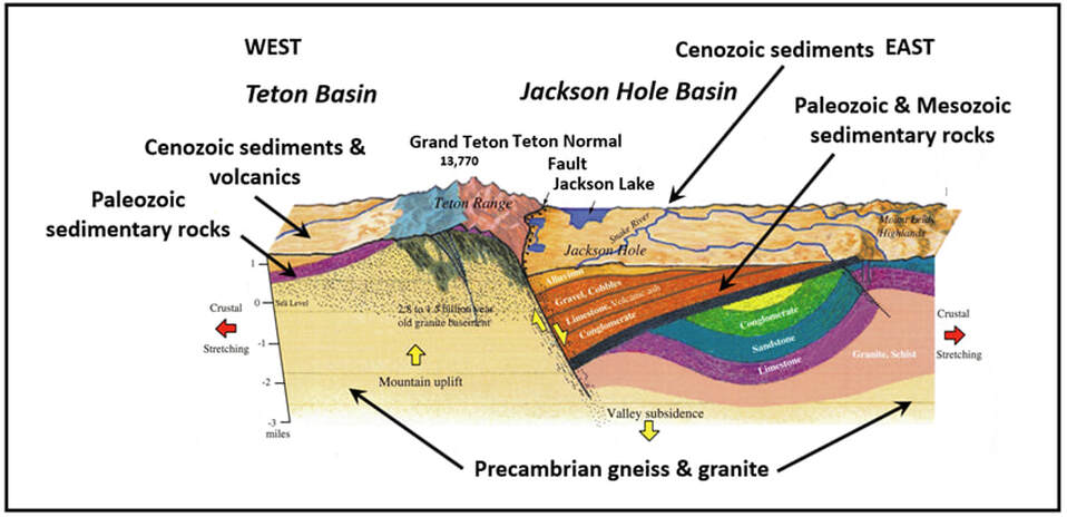
Generalized structural cross section from Teton Basin to Jackson Hole.
Image: After Smith, R.B. and Siegel, L.J., 2000, Windows into the Earth: The Geologic Story of Yellowstone and Grand Teton National Parks, Fig. 5.3, p.92.
Image: After Smith, R.B. and Siegel, L.J., 2000, Windows into the Earth: The Geologic Story of Yellowstone and Grand Teton National Parks, Fig. 5.3, p.92.
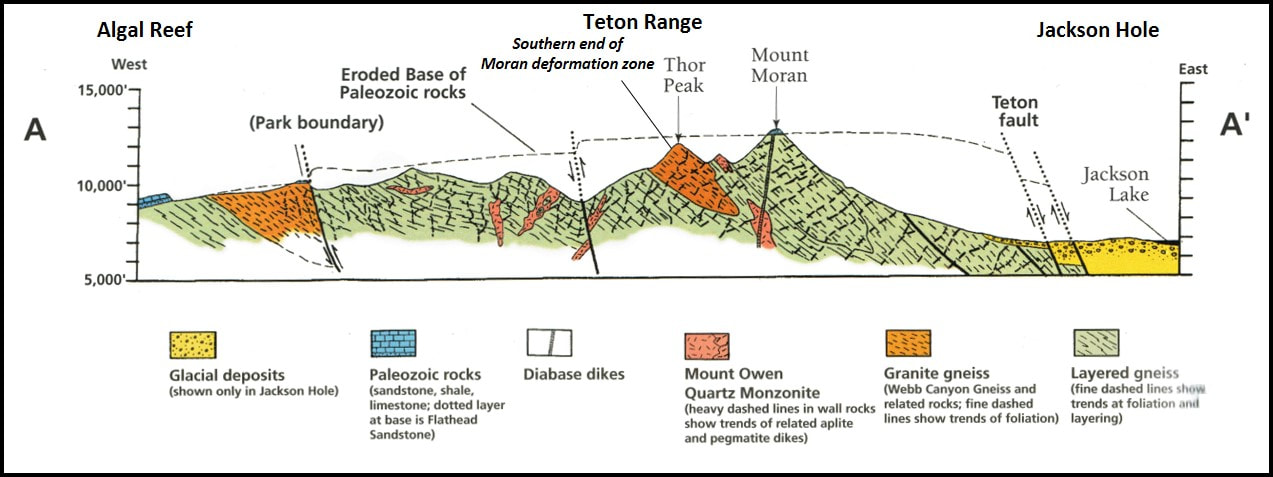
Detailed structural cross section AA’ showing uplift rotation of basement blocks along faults and down dropping of Jackson Hole. Remnant beds of Paleozoic rock onlaps the Precambrian rocks on the west flank of the Teton Range.
Image: After Love, J.D., Reed, J.C., Jr., and Pierce, K.L., 2003, Creation of the Teton Landscape: The Geologic Story of Grand Teton National Park, 2nd Edition: Fig. 17, p. 30.
Image: After Love, J.D., Reed, J.C., Jr., and Pierce, K.L., 2003, Creation of the Teton Landscape: The Geologic Story of Grand Teton National Park, 2nd Edition: Fig. 17, p. 30.
The back side (western slope) of the Tetons is seldom viewed by tourists, but holds two exceptional geologic features. On the youngest mountain range in the Rocky Mountains is evidence of the Earth’s oldest known continental collision. They contain the oldest preserved high-temperature high-pressure rocks in the world. Plate tectonics, the unifying theory of geology, was active at least as far back as 2.7 billion years ago.
Cambrian sedimentary structures built by microbial mats stand in relief like a modern coral reef. The microbes are some of the earliest and longest surviving lifeform on the planet. They range from Precambrian to the present day. Their waste product, oxygen, changed the planet to a habitable place for multicellular lifeforms.
Cambrian sedimentary structures built by microbial mats stand in relief like a modern coral reef. The microbes are some of the earliest and longest surviving lifeform on the planet. They range from Precambrian to the present day. Their waste product, oxygen, changed the planet to a habitable place for multicellular lifeforms.

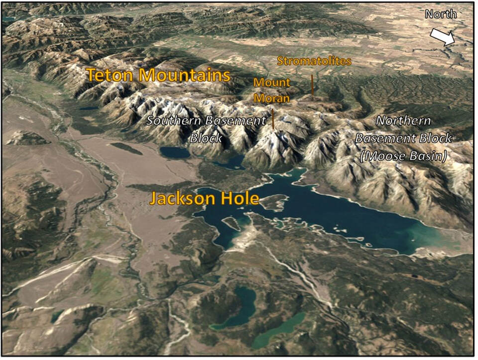
West aerial view behind Mount Moran showing location of geologic features discussed.
Image: Google Earth
Image: Google Earth

The material on this page is copyrighted