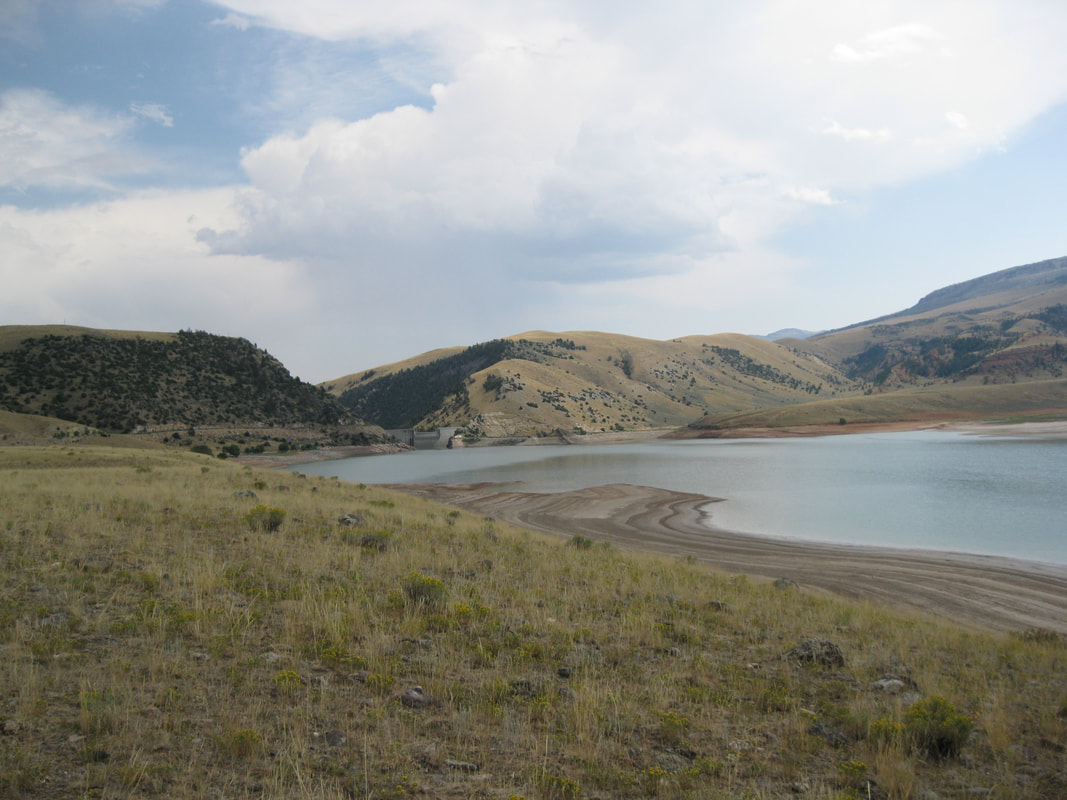
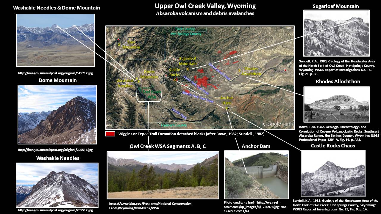
Anchor Dam with Tensleep Sandstone outcrop, Owl Creek Mountains in background
Image by Mark Fisher
Image by Mark Fisher
Wow Factor (3 out of 5 stars):
Geologist Factor (2 out of 5 stars):
Attraction
Man versus nature story with a dam and a leaking reservoir. A beautiful and isolated place in Wyoming with a scenic drive through large cattle and sheep ranches in the Owl Creek Valley, expansive views of the Owl Creek & Absaroka Mountains, wildlife, petroglyphs, and large folds of sedimentary rock. Enjoy!
History of Owl Creek Valley
In 1871 John Dwight Woodruff built the first permanent home in the Bighorn Basin along Owl Creek on the hunting grounds of the Crow and Shoshone Indians. It was also within the territory of frequent raids by the Arapahoe, Cheyenne and Sioux tribes. The nearest white neighbors were the soldiers at Camp Brown, 50 miles away across the mountains near Lander.
J.D. Woodruff sitting by the front door of his cabin on Owl Creek.
Image: Ritter, L.D.W., 1926, Biographical Sketch of John Dwight Woodruff: Annals of Wyoming, Vol. 3, No. 4, frontispiece; https://archive.org/stream/annalsofwyom314192526wyom#page/n121/mode/2up
Image: Ritter, L.D.W., 1926, Biographical Sketch of John Dwight Woodruff: Annals of Wyoming, Vol. 3, No. 4, frontispiece; https://archive.org/stream/annalsofwyom314192526wyom#page/n121/mode/2up
Woodruff sold the property in 1881 to Captain Robert Torrey who, together with his brother Colonel Jay Torrey (the originator of the “cowboy units” idea and commander of the ill-fated Torrey’s Rocky Mountain Rough Riders, 2nd U.S.V. Calvary (see http://www.wyomingtalesandtrails.com/cheyennecapbldg1.html), established a large cattle ranch. A post office was opened on the ranch in 1885 and given the name Embar after the Torrey’s cattle brand.
Cattle brands of local ranches that gave names to Post Offices, anticlines and elements of the Owl Creek Irrigation Project. Left: Torrey Embar Ranch brand: “M –“ (original name for reservoir). Right: Blonde Anchor Ranch brand (name for dam).
Image: Left: After Wyoming Places website, originally from the Lander Clipper Newspaper, May 26, 1899, http://wyomingplaces.pbworks.com/w/page/12715041/Embar
Right: Official Brand Book of the State of Wyoming: State Board of Livestock Commissioners of Wyoming, 1913, p. 189. https://archive.org/stream/officialbrandboo00boar#page/188/mode/2up/search/anchor
In 1960 the Bureau of Reclamation completed a dam about 35 miles west of Thermopolis. Its reservoir was planned to provide water to the Owl Creek District. The dam project was named after C. E. Blonde’s Anchor Ranch that was in the area to be submerged beneath the reservoir. The name Anchor comes from his cattle brand.
East view of Anchor Dam and the diminished Embar (Anchor) Reservoir. The Tensleep Formation outcrop is the tree covered area on the south (right) canyon wall. The tree line displays the asymmetry of the fold with the steep flank toward the camera and the gentle flank toward the horizon. The isolation dikes to the right of the dam were first installed in 1967, and rebuilt in 1975 and 1978. These dikes were built to reduce water loss. The image shows the western mouth of the canyon where South Owl Creek cuts across the axis of the Anchor Anticline
Image by Mark Fisher
Image by Mark Fisher
Geology of Owl Creek Valley
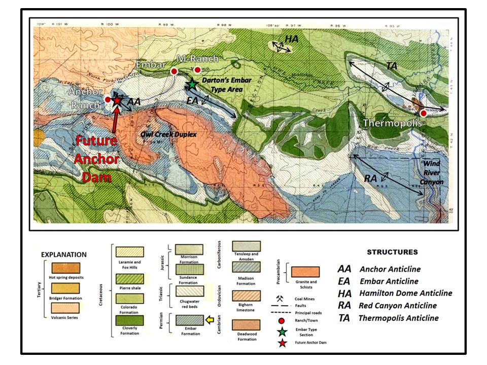
In 1905 Nelson Horatio Darton, U.S. Geological Survey (USGS) geologist, named a formation overlying the Pennsylvanian Tensleep Sandstone, and below the Triassic Chugwater red beds, the Embar after the nearby ranch and Post Office. The type area is in Red Creek Canyon along the Owl Creek mountain front. The name Embar has been abandoned by the U.S. Geological Survey and replaced with two formations: the Triassic Dinwoody and Permian Phosphoria. The name is still used in several oil fields in the Bighorn Basin where oil was discovered in this carbonate unit before the name was changed.
Portion of Darton’s 1905 Geologic Map of the Owl Creek Mountains. Embar Formation is shown by the diagonally stripped medium blue as shown at Darton’s type area and the future dam site;
Image: After http://uwdigital.uwyo.edu/islandora/object/wyu%3A121070
Image: After http://uwdigital.uwyo.edu/islandora/object/wyu%3A121070
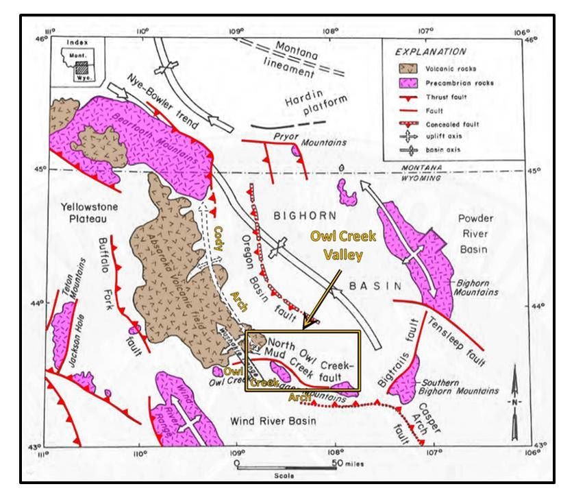
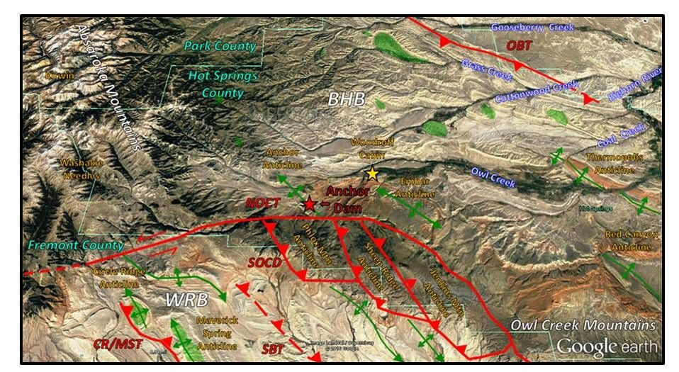
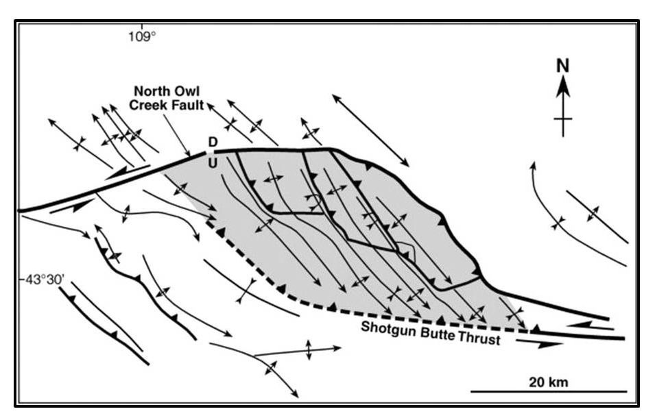
The Owl Creek Valley extends 50 miles from its headwaters in the Washakie Needles to the confluence with the Bighorn River just downstream of Thermopolis. The valley area covers over 500 square miles and has about 8,000 feet of topographic relief. The Absaroka Mountains lie to the west and the Owl Creek Mountains lie to the south. The eastern boundary is the Bighorn River and the drainage divide with Cottonwood Creek marks the north boundary. The Owl Creek and Cody Laramide arch structural trends intersect in this corner of the Bighorn Basin. The North Owl Creek thrust fault has left-lateral motion that has faulted Paleozoic rocks over the south ends of anticlines in the Owl Creek Valley. The South Owl Creek fault system developed a duplex structure that elevated three blocks of Precambrian crystalline rock to the surface. Middle Eocene Absaroka Volcanic rocks intrude and overlie the Paleozoic and Mesozoic sedimentary section at the valley’s western margin. These volcanic rocks are the youngest deposits in the volcanic field. The Washakie Needles are the 38.8 million-year-old volcanic vent plug of this Eocene magmatic activity.
Generalized tectonic map of the Bighorn Basin showing the location of the Owl Creek Valley.
Image: Blackstone, D.L., Jr., 1986, Foreland Compressional Tectonics: Southern Bighorn Basin and Adjacent Areas, Wyoming: Wyoming State Geological Survey, Report of Investigations No. 34, Fig. 2, p. 2;
http://www.wsgs.wyo.gov/products/wsgs-1986-ri-34.pdf
Image: Blackstone, D.L., Jr., 1986, Foreland Compressional Tectonics: Southern Bighorn Basin and Adjacent Areas, Wyoming: Wyoming State Geological Survey, Report of Investigations No. 34, Fig. 2, p. 2;
http://www.wsgs.wyo.gov/products/wsgs-1986-ri-34.pdf
North aerial view of Owl Creek Valley in southwest Bighorn Basin. Faults shown by red lines. Red triangles point in the direction of thrust surface dip and arrows denote direction of lateral offset. Notation: CR/MST: Circle Ridge/Maverick Spring Thrust, NOCT: North Owl Creek Thrust, OBT: Oregon Basin Thrust, SBT: Shotgun Butte Thrust, SOCD: South Owl Creek Duplex. Anticlines shown by green lines. Oil fields highlighted in green. Woodruff cabin shown by gold star. BHB: Bighorn Basin; WRB: Wind River Basin.
Image: Google Earth
Image: Google Earth
Simplified map of the Owl Creek duplex structure, Wyoming (modified from Paylor and Yin, 1993).
Image: McClay, K. and Bonora, M., 2001, Analog models of restraining stepovers in strike-slip fault systems: AAPG Bulletin, v. 85, no. 2, Fig. 20, p. 253; http://aapgbull.geoscienceworld.org/content/gsaapgbull/85/2/233/F20.large.jpg
Image: McClay, K. and Bonora, M., 2001, Analog models of restraining stepovers in strike-slip fault systems: AAPG Bulletin, v. 85, no. 2, Fig. 20, p. 253; http://aapgbull.geoscienceworld.org/content/gsaapgbull/85/2/233/F20.large.jpg
Water Chemistry of Owl Creek Valley
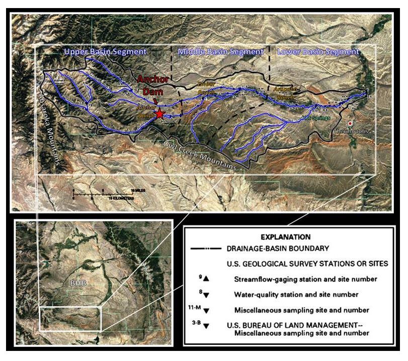
Aerial view of Owl Creek Valley drainage sub-basin in southwest Bighorn Basin (BHB). Anchor Dam is located at the confluence of the Middle and South Forks of Owl Creek. White dash lines separate upper, middle, and lower drainage basin segments.
Image: Base: Google Earth; Overlay: After Ogle, K.M., 1992, Surface- and Ground-Water Quality in the Owl Creek Basin, North-Central Wyoming: U.S. Geological Survey Water-Resources Investigations Report 91-4108, Fig. 2, p. 6-7; https://pubs.usgs.gov/wri/1991/4108/report.pdf
Image: Base: Google Earth; Overlay: After Ogle, K.M., 1992, Surface- and Ground-Water Quality in the Owl Creek Basin, North-Central Wyoming: U.S. Geological Survey Water-Resources Investigations Report 91-4108, Fig. 2, p. 6-7; https://pubs.usgs.gov/wri/1991/4108/report.pdf
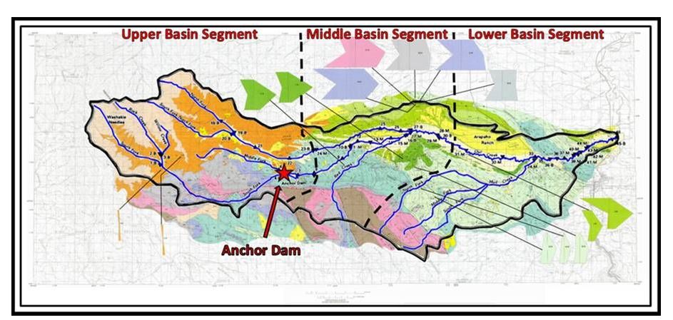
Geologic and water chemistry map of the Owl Creek Valley, southwest Bighorn Basin. Basin segments shown by red dashed line. Polygons are modified Stiff plots of water composition as described in explanation.
Image: After Ogle, K.M., 1992, Surface- and ground-water quality in the Owl Creek basin, north-central Wyoming: U.S. Geological Survey, Water-Resources Investigations Report 91-4108, scale 1:100,000; https://pubs.usgs.gov/wri/1991/4108/plate-1.pdf
Image: After Ogle, K.M., 1992, Surface- and ground-water quality in the Owl Creek basin, north-central Wyoming: U.S. Geological Survey, Water-Resources Investigations Report 91-4108, scale 1:100,000; https://pubs.usgs.gov/wri/1991/4108/plate-1.pdf
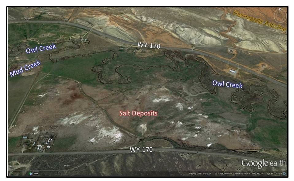
The drainage basin has three segments based on the water chemistry of the stream and upon the geology over which it flows: upper, middle, and lower. The western, upper segment drains the volcanoclastic deposits of the Absaroka Volcanic Supergroup (Wiggins, Teepee Trail, and Aycross Formations) and consists of pebble to boulder-size clasts and has an average total dissolved solids (TDS) concentration of 171 mg/l. The middle basin segment begins about one and three-quarter mile downstream (east) of Anchor Dam. Here the coarser clasts are buried by sand and silt. The North and South fork of Owl Creek and Red Creek drain across Paleozoic and Mesozoic rocks developing steep canyons through Anchor and Embar Anticlines. The stream valley widens on the less resistant Upper Cretaceous rocks. The average TDS concentration is 566 mg/l. The significant increase in all ions in the water is probably due to a combination of bedrock geology and irrigation runoff. The lower segment of Owl Creek flows over mainly Upper Cretaceous units and is joined by Mud Creek about 1,200 feet west of Wyoming Highway 120. The alluvium is mainly a mix of silt and clay. The average TDS of the water has increased to 2,340 mg/l. Salt deposits are visible along the stream bank near the intersection of WY-170 and WY-120.
White patches of salt encrustation in lower basin segment of Owl Creek are the result of irrigation with high TDS water.
Image: Google Earth
Image: Google Earth
The Wyoming Department of Environmental Quality classifies water on the concentration of total dissolved solids (TDS). Class I water has a TDS < 500 mg/l (or ppm) is usable as drinking water (potable). Class II water has a TDS range > 500 and 2,000 mg/l and may be used for agriculture. Class III water has a TDS range > 2,000 and < 10,000 mg/l can be used for livestock. Class IV water has TDS > 10,000 mg/l and is reserved for industrial use. Only the upper basin segment of the Owl Creek Valley has potable water. The overall trend within the system is a gradual increase in TDS and concentrations of major ions downstream, with significant step changes in these levels at the segment boundaries. The major industry in the valley is stock raising with supporting agriculture. Over ninety percent of the water in the valley is used for irrigation to raise animal feed, and to water livestock (Class II and III).
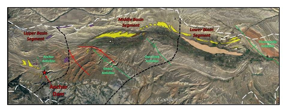
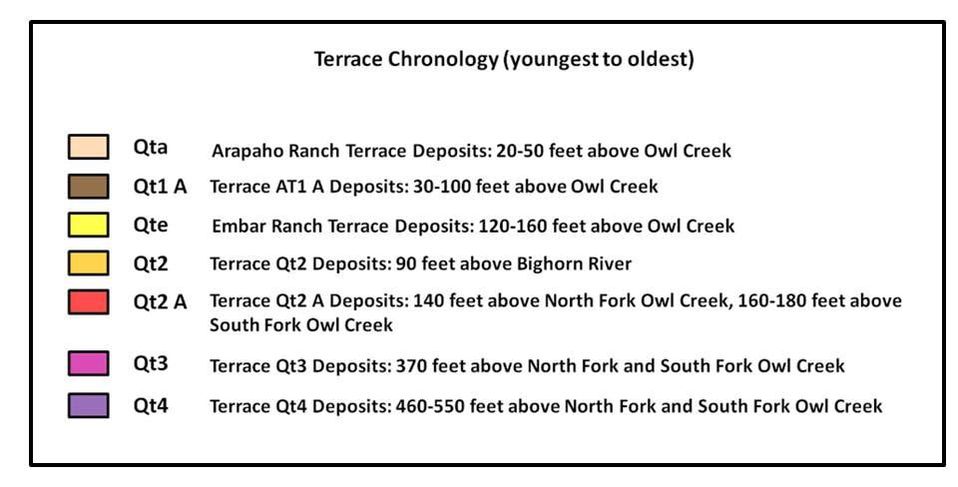
Several terrace levels are present adjacent to the streams, mainly observed on the north flank of North Owl Creek. Terrace deposits mark the former location and elevation of paleostreams. They are caused by a change in base level (the lowest level at which running water can flow) as the stream erodes the surrounding alluvium and bedrock. The Owl Creek Valley has two named, and five numbered terraces.
Several terrace levels are present adjacent to the streams, mainly observed on the north flank of North Owl Creek. Terrace deposits mark the former location and elevation of paleostreams. They are caused by a change in base level (the lowest level at which running water can flow) as the stream erodes the surrounding alluvium and bedrock. The Owl Creek Valley has two named, and five numbered terraces.
Aerial view of stream terraces in the Owl Creek Valley.
Image: Base: Google Earth; Data: Cooley, M.E. and Head, W.J., 1982, Hydrogeologic features of the alluvial deposits in the Owl Creek Valley, Bighorn Basin, Wyoming: U.S. Geological Service Water-Resources Investigations Report 82-4007, Plate 1; https://pubs.usgs.gov/wri/1982/4007/plate-1.pdf
Image: Base: Google Earth; Data: Cooley, M.E. and Head, W.J., 1982, Hydrogeologic features of the alluvial deposits in the Owl Creek Valley, Bighorn Basin, Wyoming: U.S. Geological Service Water-Resources Investigations Report 82-4007, Plate 1; https://pubs.usgs.gov/wri/1982/4007/plate-1.pdf
Geology of Anchor Dam - The "Hole" Story
Cassius Fisher USGS geologist reported in 1906 that Owl Creek
“… has a wide, fertile valley, only a part of which is irrigated, due to a shortage of water. Owl Creek has a vigorous flow only for a short period during the flood season, but this flow rapidly decreases, and in midsummer the stream below Embar (i.e. Embar Ranch) is nearly dry.”
Fisher, C.A., 1906, Geology and Water Resources of the Bighorn Basin, Wyoming: U.S. Geological Survey Professional Paper 53, p. 45; https://pubs.usgs.gov/pp/0053/report.pdf
The U.S. Bureau of Reclamation began evaluating a dam irrigation project for this sub-basin in 1934. A geologic report and map of the proposed dam site was prepared in 1935. This report was based on one week of reconnaissance field work and reached five conclusions:
1. It is believed that the project is feasible in so far as geological relationships bear upon it.
2. The bed rock of the dam site is adequate to support an earth fill dam 160 feet high.
3. No avenues of escape are known whereby large water losses would be encountered within the closing contour of the reservoir site. No such avenues are believed to exist.
4. There is no danger of water piping through the bed rock of the dam abutments.
5. Some seepage loss may occur along weathered joint planes which cut the bed rock of the dam abutments. Investigation of this problem awaits subsurface investigations of the dam site.
Knight, S.H. and Hurwitz, G., 1935, Preliminary on the geology of the Anchor Dam and Reservoir site, Hot Springs County, Wyoming, p. 1-2.
The report did not include observations from locals on historic water loss in irrigation ditches to “holes in the ground,” nor reports of sinkholes and seepage along the Owl Creek drainage.
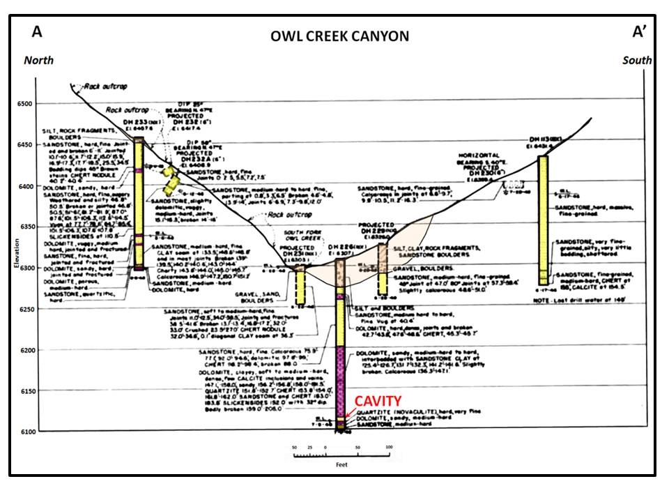
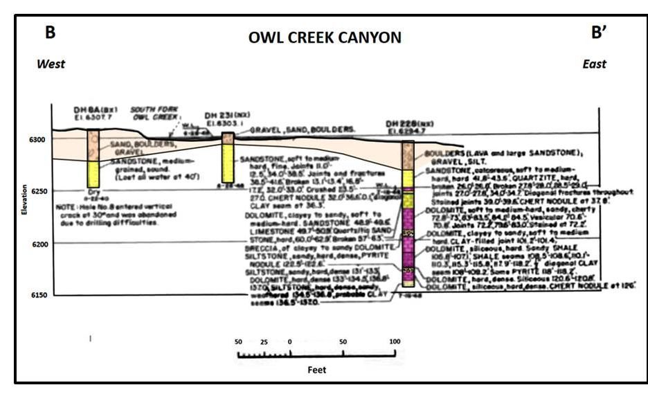
The estimated 3.4-million-dollar project envisioned a 208-foot concrete arch dam with a 440-acre reservoir to meet the irrigation needs of the valley. Construction began in 1958 and encountered bedrock foundation problems that required movement of the bridge abutments westward. Solution cavities were discovered in the dolomite interbeds of the “middle” Tensleep Sandstone. A drilling program revealed additional solution cavities which were filled with concrete and grout.
Topographic index map and cross sections showing geology of exploration drill holes at Anchor Dam. The Sandstone described in these cross sections (yellow) is the Tensleep.
Images: U.S. Bureau of Reclamation, 1962, Anchor Dam: Constructed 1957-1961, Missouri River Basin Project, Wyoming; Technical Record of Design and Construction, Fig. 7, p. 12; https://babel.hathitrust.org/cgi/pt?id=wu.89038873766;view=1up;seq=31
Images: U.S. Bureau of Reclamation, 1962, Anchor Dam: Constructed 1957-1961, Missouri River Basin Project, Wyoming; Technical Record of Design and Construction, Fig. 7, p. 12; https://babel.hathitrust.org/cgi/pt?id=wu.89038873766;view=1up;seq=31
Consultants believed that the Dinwoody and Chugwater formations to the west of the dam would adequately seal the reservoir. This conclusion was reached even though a 300-foot circular crack in the Red Peak Member of the Chugwater Formation had appeared in 1958, in the future reservoir area, 700 feet west of the right-hand abutment. Two other sinkholes in the reservoir area had also been discovered. Dam construction was completed in 1960 and filling of the reservoir commenced shortly afterward.
Sinkholes discovered prior to, and at the start of dam construction (April 1957). Left: Sinkhole #1 (30-foot diameter with 35-foot depth), about 2,000 feet northwest of the dam site, first observed in 1955 and formed in 1952. Right: Sinkhole #2 (15-foot diameter with 10-foot depth), 300 feet west of Sinkhole #1, first observed May 1957.
Images: U.S. Bureau of Reclamation, 1962, Anchor Dam: Constructed 1957-1961, Missouri River Basin Project, Wyoming; Technical Record of Design and Construction, Figs. 8 and 9, p. 13; https://babel.hathitrust.org/cgi/pt?id=wu.89038873766;view=1up;seq=31
Images: U.S. Bureau of Reclamation, 1962, Anchor Dam: Constructed 1957-1961, Missouri River Basin Project, Wyoming; Technical Record of Design and Construction, Figs. 8 and 9, p. 13; https://babel.hathitrust.org/cgi/pt?id=wu.89038873766;view=1up;seq=31
West view of Anchor dam before the first attempt to fill the reservoir, November 16, 1960.
Image: U.S. Bureau of Reclamation, 1962, Anchor Dam: Constructed 1957-1961, Missouri River Basin Project, Wyoming; Technical Record of Design and Construction, Frontispiece; https://babel.hathitrust.org/cgi/pt?id=wu.89038873766;view=1up;seq=31
Image: U.S. Bureau of Reclamation, 1962, Anchor Dam: Constructed 1957-1961, Missouri River Basin Project, Wyoming; Technical Record of Design and Construction, Frontispiece; https://babel.hathitrust.org/cgi/pt?id=wu.89038873766;view=1up;seq=31
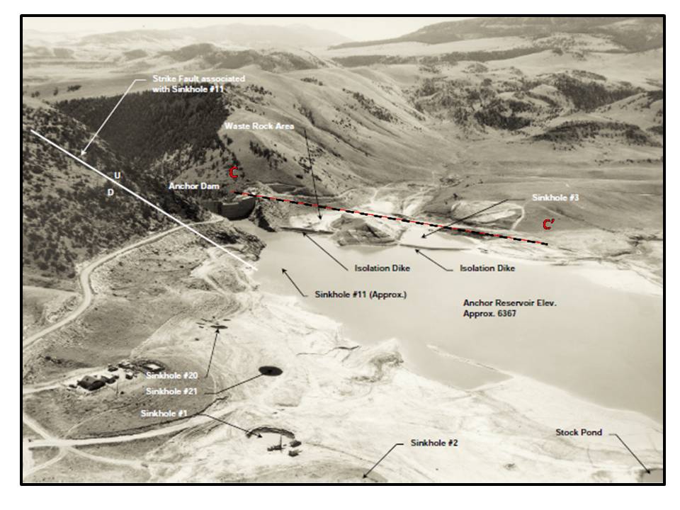
In 1961, the crack recognized in 1958 collapsed, forming a sinkhole (sinkhole #3) that drained the reservoir at a rate reaching 2,210 cubic feet per second. Multiple unsuccessful attempts to plug this hole led to a dike being constructed around it to isolate from the remaining reservoir. Since then, over 50 sinkholes have developed in the reservoir, generally in an area 600 feet upstream from the dam. The total cost of construction and remediation efforts was over seven million dollars.
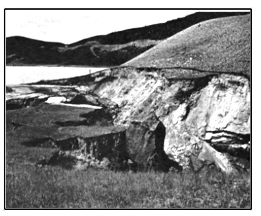
Seventy-foot-deep sinkhole #3 developed during the first attempt to fill reservoir from the 300-foot diameter crack observed in 1958.
Image: U.S. Bureau of Reclamation, 1962, Anchor Dam: Constructed 1957-1961, Missouri River Basin Project, Wyoming; Technical Record of Design and Construction, Fig. 10, p. 14; https://babel.hathitrust.org/cgi/pt?id=wu.89038873766;view=1up;seq=31
Image: U.S. Bureau of Reclamation, 1962, Anchor Dam: Constructed 1957-1961, Missouri River Basin Project, Wyoming; Technical Record of Design and Construction, Fig. 10, p. 14; https://babel.hathitrust.org/cgi/pt?id=wu.89038873766;view=1up;seq=31
Southeast aerial view of Anchor dam and reservoir on August 4, 1967. Cross section C-C’ shown by dashed black & red line.
Image: Short Elliott Hendrickson Inc., 2008, Final Report Owl Creek Irrigation District Storage Level II Study: Wyoming Water Development Commission, Fig. 3.1-1; http://library.wrds.uwyo.edu/wwdcrept/Owl_Creek/Owl_Creek-Irrigation_District_Storage_Level_II-Final_Report-2008.pdf
Image: Short Elliott Hendrickson Inc., 2008, Final Report Owl Creek Irrigation District Storage Level II Study: Wyoming Water Development Commission, Fig. 3.1-1; http://library.wrds.uwyo.edu/wwdcrept/Owl_Creek/Owl_Creek-Irrigation_District_Storage_Level_II-Final_Report-2008.pdf
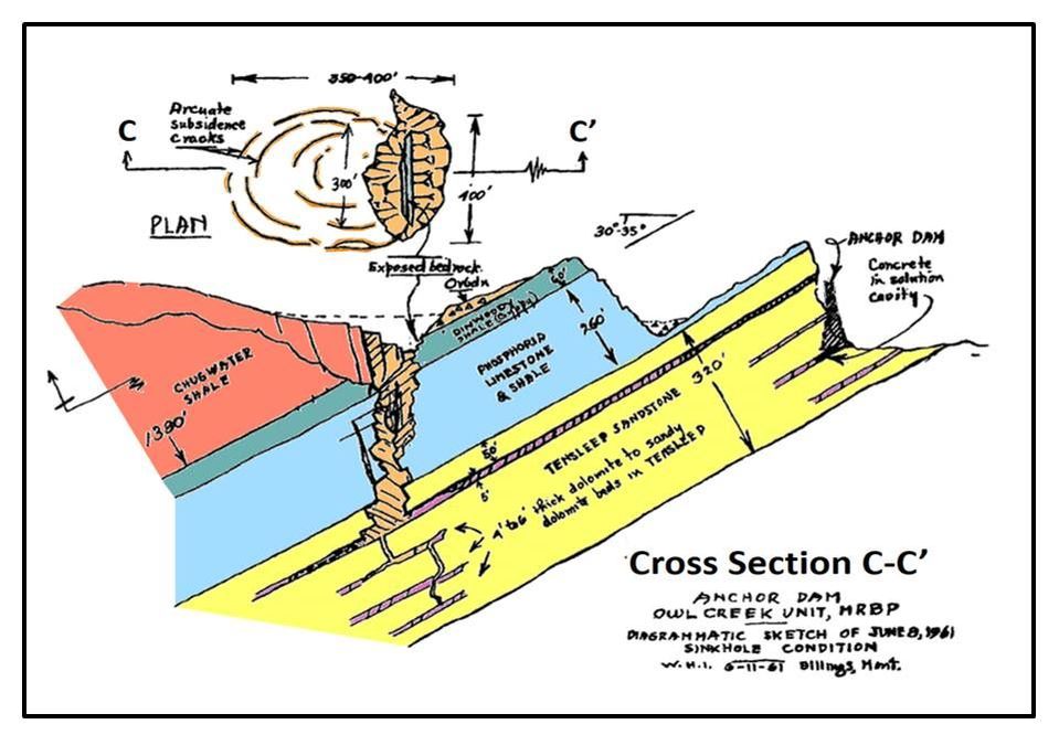
Geologic cross section and map through Sinkhole #3. Cross section is drawn perpendicular to the anticlinal fold axis. Note the rectilinear shape on the margins of the solution zone that follows the trends of fractures. Map Geologic notation: Qa: Quaternary alluvium, Qt: Quaternary bench deposit, Tta: Tertiary Tepee Trail and Aycross Formations, TrP: Triassic Chugwater, Dinwoody and Phosphoria Formations, PM: Pennsylvanian Tensleep and Amsden Formations, OC: Ordovician Bighorn and Cambrian Gallatin, Gros Ventre and Flathead Formations, pC: Precambrian igneous and metamorphic rocks.
Image: Cross Section: After Jarvis, T., 2003, The Money Pit: Karst Failure of Anchor Dam, Wyoming: in Johnson, K.S. and Neal, J.T., eds., Evaporite Karst and Engineering/Environmental Problems in the United States: Oklahoma Geological Survey Circular 109, Fig. 6, p. 276; http://www.ogs.ou.edu/pubsscanned/Circulars/circular109.pdf;
Map: After Ogle, K.M., 1992, Surface- and ground-water quality in the Owl Creek basin, north-central Wyoming: U.S. Geological Survey, Water-Resources Investigations Report 91-4108, scale 1:100,000; https://pubs.usgs.gov/wri/1991/4108/plate-1.pdf
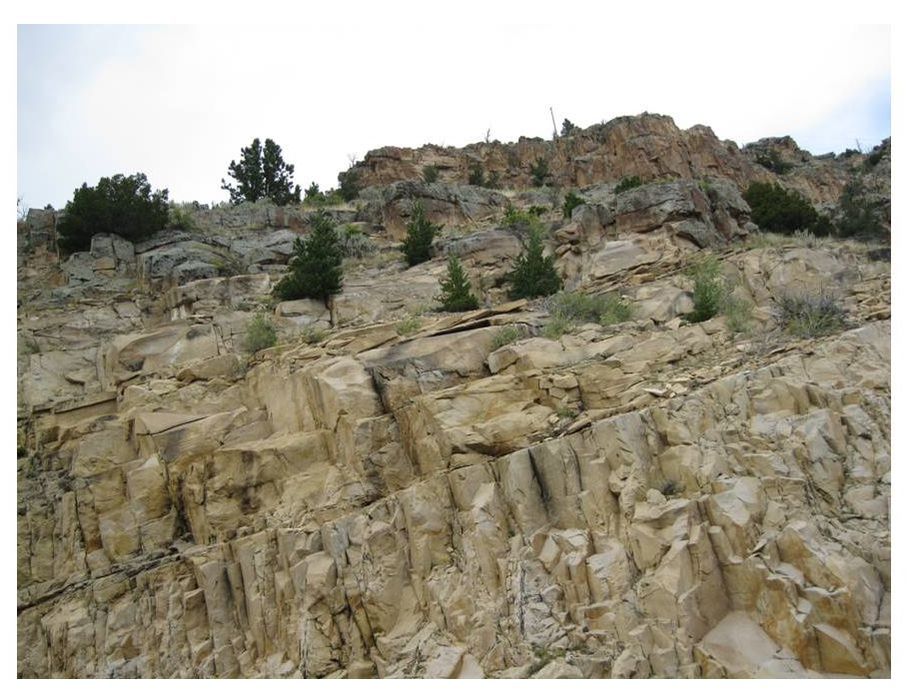
Fractured Tensleep Sandstone at Anchor Dam near north abutment
Image by Mark Fisher
Image by Mark Fisher
The geology exposed at the surface of the dam and reservoir consists of Lower Triassic Chugwater, Permian Phosphoria and Pennsylvanian Tensleep. The geologic column displays these units and the underlying formations that play a role in the area. The dam is located on the west flank of the asymmetric Anchor anticline or fold. The axis of the fold is oriented north 40 degrees west. The geologic structure was formed during Laramide mountain building and is elevated on a thrust fault that does not reach the surface but created fractures within all the Paleozoic Formations in the upthrown block. There are two regional vertical joint sets observed in the canyon striking N15W and N60E. The joints cut nearly perpendicular to the bedding planes at a spacing of one to four feet apart. This fracture system provided pathways for water movement in the subsurface.
Owl Creek Valley area stratigrapic column for Anchor Dam and Reservoir site. The Triassic formations contain thin veins and beds of anhydrite (gypsum at the surface). The Tensleep contains both dolomitic and anhydritic cement. Gypsum is much more soluble in water than dolomite or limestone. The Madison solution collapse zones in the upper part of the formation are due to the dissolution of evaporite beds like anhydrite.
Image: Hinckley, B.S., Heasler, H.P. and King, J.K., 1982, The Thermopolis Hydrothermal system with an Analysis of Hot Springs State Park: Wyoming State Geological Survey Preliminary Report No. 20, Fig. 3, p. 7. https://www.osti.gov/scitech/servlets/purl/6053845/
Image: Hinckley, B.S., Heasler, H.P. and King, J.K., 1982, The Thermopolis Hydrothermal system with an Analysis of Hot Springs State Park: Wyoming State Geological Survey Preliminary Report No. 20, Fig. 3, p. 7. https://www.osti.gov/scitech/servlets/purl/6053845/
The potentiometric surface (the level groundwater can rise under reservoir pressure) of the Tensleep aquifer beneath the dam and reservoir is at 5,500 to 5,700 foot elevation. The reservoir is at a maximum height of 6,400 feet, which results in a 700 to 900 foot gravity drain if a connection pathway is present. Water losses at the reservoir are estimated to be 12,500 acre-feet per year and they do not reappear downstream of the dam. Surface water flows generally eastward along the topography. Ground water moves to the north-northeast as shown by the Tensleep potentiometric surface map. Original permitted design capacity of the reservoir was 17,412 acre-ft. To prevent damage to the isolation dikes and minimize sinkholes, capacity is limited to 7,572 acre-ft which is 43 percent of original design.
Potentiometric map of Tensleep aquifer surface in the Owl Creek Valley showing the elevation of the top of the water table. Water flows in this subsurface aquifer perpendicular to, and from high to lower contours. The Madison aquifer, the largest in the state, is about 600 feet below the Tensleep and flows in a similar direction. Groundwater movement is to the north-northeast in Anchor dam and reservoir area as shown by the white arrows. Owl Creek surface waters are flowing from west to east along topography.
Image: After Taucher, P. Bartos, T.T., Clarey, K.E., Quillinan, S.A., Hallberg, L.L., Clark, M.L., Thompson, M., Gribb, N., Worman, B. and Gracias, T., 2012, Wind/Bighorn River Basin Water Plan Update Groundwater Study Level 1 (2008–2011) Available Groundwater Determination Technical Memorandum: Wyoming State Geological Survey, Plate XII; http://waterplan.state.wy.us/plan/bighorn/2010/gw-finalrept/plate_XII.pdf
Image: After Taucher, P. Bartos, T.T., Clarey, K.E., Quillinan, S.A., Hallberg, L.L., Clark, M.L., Thompson, M., Gribb, N., Worman, B. and Gracias, T., 2012, Wind/Bighorn River Basin Water Plan Update Groundwater Study Level 1 (2008–2011) Available Groundwater Determination Technical Memorandum: Wyoming State Geological Survey, Plate XII; http://waterplan.state.wy.us/plan/bighorn/2010/gw-finalrept/plate_XII.pdf
The upper portion of the Madison Formation has major karst (cave) and solution callapse zones developed regionally. Flow within this Madison aquifer is similar to that developed in the Tensleep Sandstone and this carbonate unit may be a major contributor to the water loss in the reservoir.
The Anchor dam and reservoir were located on the steeply dipping flank of an anticline, in highly fractured strata, and on rocks susceptable to sinkhole development. That’s three strikes, and in dam siting, as well as baseball, you’re out.
Alton B. Oviatt, a former history professor of mine, used to often remark: “Hindsight, is better than foresight, by a damn sight”. Well professor, this is one damn dam site where the phrase wholey fits.
Historic Anchor Dam and Reservoir Location Pictures (1935)
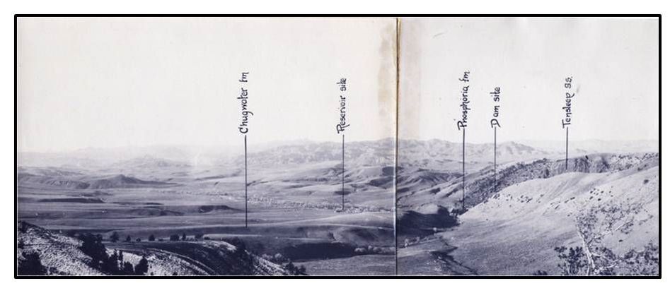
Northwest view of Anchor Dam locality before construction.
Image: Knight, S.H. and Hurwita, G., 1935, Preliminary Report on the Geology of the Anchor Dam and Reservoir Sites Hot Springs County, Wyoming: Wyoming State Geological Survey, unpublished report, Fig. 1.
Image: Knight, S.H. and Hurwita, G., 1935, Preliminary Report on the Geology of the Anchor Dam and Reservoir Sites Hot Springs County, Wyoming: Wyoming State Geological Survey, unpublished report, Fig. 1.
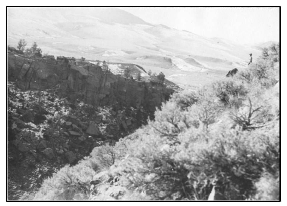
Southwest view of Anchor Dam location before construction.
Image: Knight, S.H. and Hurwita, G., 1935, Preliminary Report on the Geology of the Anchor Dam and Reservoir Sites Hot Springs County, Wyoming: Wyoming State Geological Survey, unpublished report, Fig. 2.
Image: Knight, S.H. and Hurwita, G., 1935, Preliminary Report on the Geology of the Anchor Dam and Reservoir Sites Hot Springs County, Wyoming: Wyoming State Geological Survey, unpublished report, Fig. 2.
Southeast view of Anchor Dam site before construction.
Image: Knight, S.H. and Hurwita, G., 1935, Preliminary Report on the Geology of the Anchor Dam and Reservoir Sites Hot Springs County, Wyoming: Wyoming State Geological Survey, unpublished report, Fig. 3.
Image: Knight, S.H. and Hurwita, G., 1935, Preliminary Report on the Geology of the Anchor Dam and Reservoir Sites Hot Springs County, Wyoming: Wyoming State Geological Survey, unpublished report, Fig. 3.
What You Will See At Anchor Dam
It is a pretty and peaceful drive to Anchor Dam, especially after the turnoff from WY 120 to WY 170. The road is fine for a 2WD passenger car with minimal traffic, no services, and poor cell coverage. There is a small campground on the west side of Anchor Reservoir. We also recommend you take the optional side trip to see the petroglyphs at Legend Rock and visit the large concretions at Dinosaur Marbles. There are additional geological sites in the Owl Creek drainage that we have not visited, but are shown in the picture montage at the end.
Route map to Anchor Dam (blue), Legend Rock State Petroglyph Site (red), alternate route to Legend Rock (green), and Dinosaur Marbles (purple)
Image by Google Earth
Image by Google Earth
Directions To Anchor Dam
Starting in downtown Thermopolis, head west on WY 120 toward Meeteetse & Cody, 9.0 miles turn left on WY 170, 15.3 miles cross Owl Creek, long ridge on right is Cretaceous Mesaverde Formation, 18.6 miles go straight on WY 174, WY 170 turns right/north with optional side trip through Hamilton Dome Oil Field to Legend Rock State Petroglyphs Site, boundary of Wind River Indian Reservation is close to left side of road for next 10 miles, 19.3 miles road changes name to Owl Creek Road, no longer a state highway, 27.4 miles Embar with site of Woodruff Cabin (no longer exists), first non-Native American cabin in the Bighorn Basin, 29.6 miles cross South Fork Owl Creek, 33.6 miles cross North Fork Owl Creek, 35.5 miles end of pavement & road splits, turn left on South Owl Creek Road, 36.4 miles cross North Fork Owl Creek, 37.1 mile go straight at junction with BLM 1310 (road to Rock Creek and toward Washakie Needles), 38.0 miles locked gate, park on point to right and walk 0.4 miles on flat dirt road to Anchor Dam, 38.1 miles Permian Phosphoria Formation outcrops on left side of road, good collecting of fossil invertebrates such as marine bryozoans, 38.2 to 38.4 miles Pennsylvanian Tensleep Sandstone on left side of road, note numerous fractures, 38.4 miles Anchor Dam, sign states you must stay 75 feet from dam.
Camping At Anchor Dam
Located about 2 miles from the dam on the west edge of the reservoir is a perfect four-site campground in the cottonwood trees on the South Fork of Owl Creek. It has a creek, tables, fire pits, outhouse, and a hand pump for non-potable water (no drinking water). Access is on a dirt road near the high water mark on the north shore of the reservoir. Road seems fine for passenger car, but it is very sandy along the edge of the reservoir.
Campground along South Fork of Owl Creek on west edge of Anchor Reservoir
Image by Mark Fisher
Image by Mark Fisher
Legend Rock State Petroglyph Site
It has over 300 individual petroglyphs in 92 panels mainly in the Dinwoody tradition. Made during the past several thousand years, the figures include pecked animals, people and people-like features. There is a one-third mile loop trail with 15 numbered petroglyph stops along a cliff of Cretaceous Frontier Sandstone. The trail and cliff is next to Cottonwood Creek with the Hamilton Dome Oil Field just across the creek on the adjacent hill. Legend Rock is open May through September, 8 am to 6 pm. Access from October through April requires a key that can be picked up in Thermopolis at the State Bathhouse.
Directions To Legend Rock From Anchor Dam
Retrace your way back 19.4 miles toward Thermopolis, at the junction of WY 174 an WY 170, 0.0 miles turn north on WY 170 toward Hamilton Dome Oil field and Legend Rock, 0.9 miles cross Owl Creek, 1.2 miles Arapahoe Ranch HQ on right, owned and operated by the Northern Arapaho Tribe on 300,000 acres in the Wind River Indian Reservation, raises grass fed non-hormonal cattle, 5.0 miles cattle guard and start of Hamilton Dome Oil Field, discovered in 1918, it is the third largest oil field in the Bighorn Basin with an impressive cumulative production of 274 million barrels of oil, 5.3 miles turn right on gravel Hot Springs County 15, Hamilton Dome Road, 6.1 miles road becomes paved, 9.0 miles cross Cottonwood Creek, 9.6 miles turn left on gravel Hot Springs County 10, Cottonwood Creek Road, 11.9 miles turn left on Legend Rock Road, 12.1 miles gate, 12.5 miles arrive at Legend Rock parking lot. After your visit at Legend Rock, you can more quickly return to WY 120 (Cody or Thermopolis), 0.5 miles turning right from Legend Rock Road onto Hot Springs County 10 or Cottonwood Creek Road, then at 2.7 miles turn left at the stop sign on paved Hot Springs County 10. Take this road until it dead ends into WY 120 at 8.1 miles.
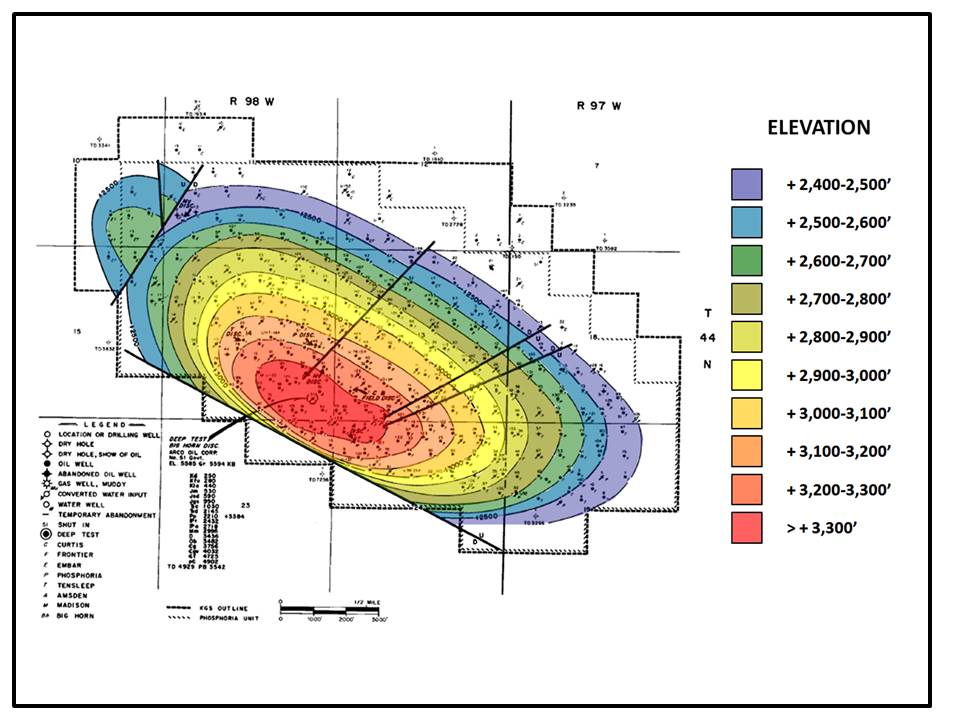
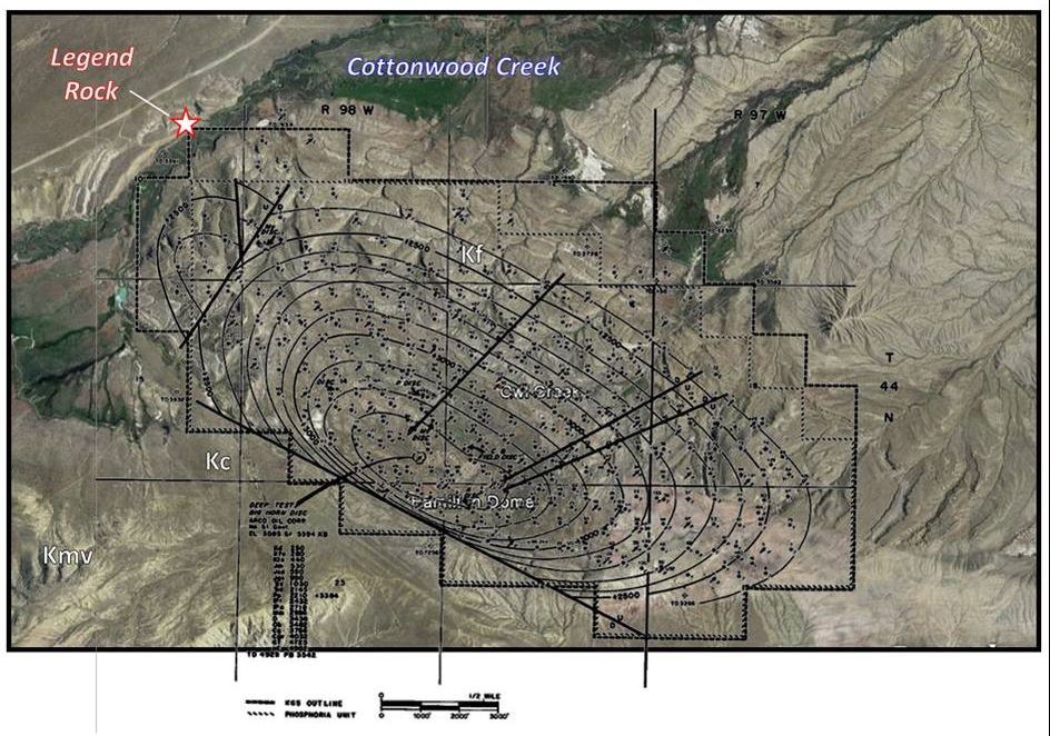
Hamilton Dome Oil Field structure map on the Permian Phosphoria Formation. Contours every 100 feet show elevation of the Phosphoria. The field is a structural accumulation in the shape of an asymmetric dome with the steeper flank to the southwest. Hamilton Dome produces from the Chugwater, Phosphoria, Tensleep, and Madison, with very minor amounts having been produced from the Darwin and Big Horn. Surface outcrops Kf = Cretaceous Frontier, Kc = Cretaceous Cody Shale, and Kmv = Cretaceous Mesaverde
Wyoming Oil and Gas Fields Symposium; Bighorn and Wind River Basin, 1989, Wyoming Geological Association,
Google Earth image
Wyoming Oil and Gas Fields Symposium; Bighorn and Wind River Basin, 1989, Wyoming Geological Association,
Google Earth image

The material on this page is copyrighted


