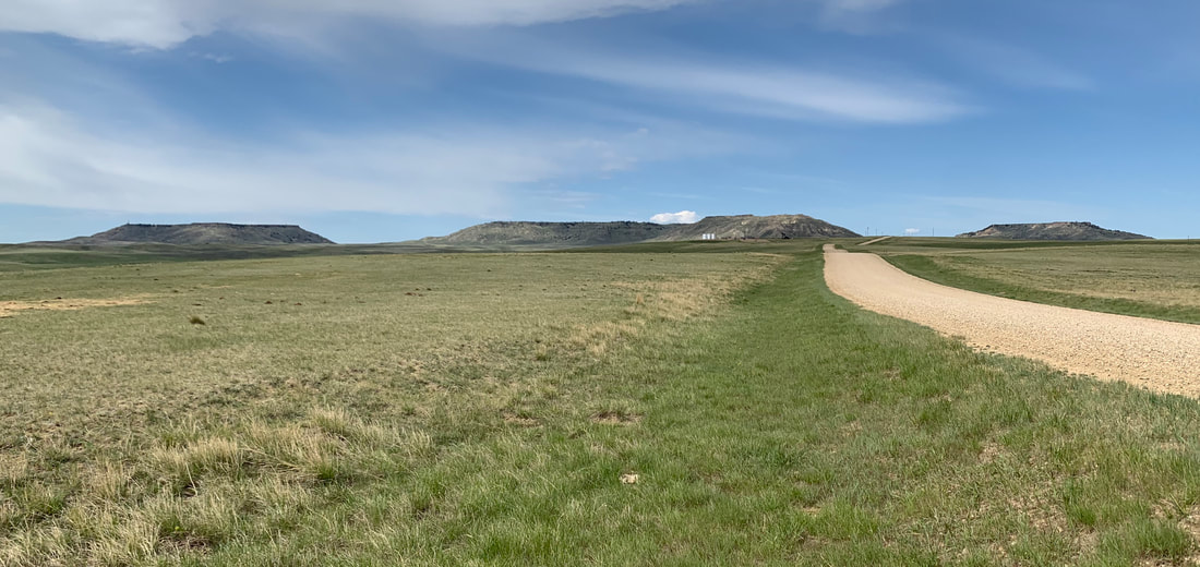
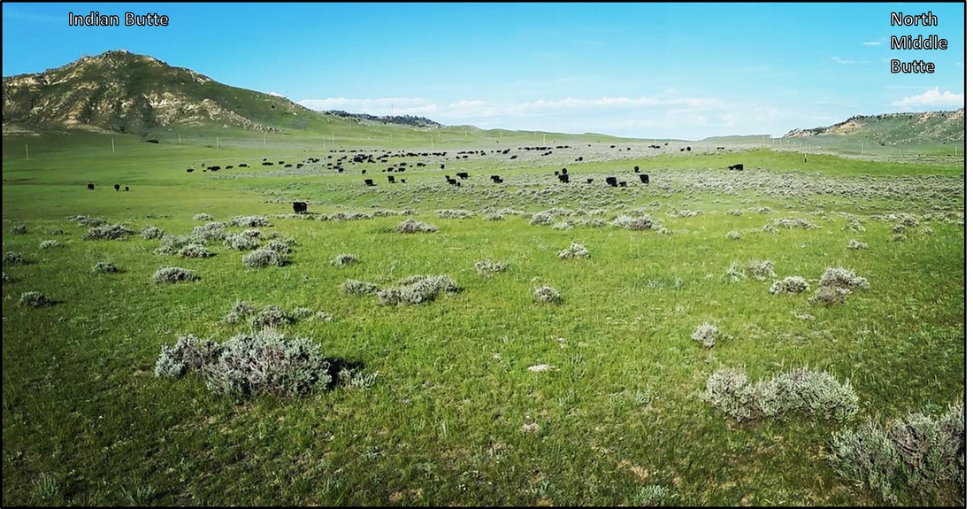
West view of Pumpkin Buttes with South, South Middle, Indian and North Middle Buttes
Image: Mark Fisher
Image: Mark Fisher
Wow Factor (1 out of 5 stars):

Geologist Factor (3 out of 5 stars):

Attraction
Erosional remnants of Tertiary basin fill that are the topographic high points and youngest sediments preserved within the Powder River Basin. The abundant natural resources here have been used by people for over 11,000 years. They are the site of the first commercial uranium discovery in Wyoming. The surface outcrop originated the “roll front” model of uranium deposition. Vast coal beds, oil, and gas have powered America into the 21st Century. There is no public access to Pumpkin Buttes. The North Butte and South Butte are on private land and the BLM land on the North Middle Butte and South Middle Butte is landlocked by private land.
History of Pumpkin Buttes
The Pumpkin Buttes rise from the rolling grasslands of the Powder River Basin like flat-topped islands in a verdant sea. The lush vegetation fed bison and other wildlife upon which Native Americans subsistence depended. The same grass fed the herds of open range livestock that entered the basin in the late 1870’s after the Indian Wars ended. The first human occupation of the area dates from about 11,000 years ago. Hunter-gatherers presence is recognized and dated from archeological sites throughout the Powder River Basin. The evidence includes shelters, tepee rings, tool and weapon artifacts, rock art, hearths and fire pits, rock cairns, bison corrals, and game bones with evidence of butchering and cooking. The basin was the scene of intertribal conflict between the Crow and Sioux over control of the hunting grounds in the 19th century.
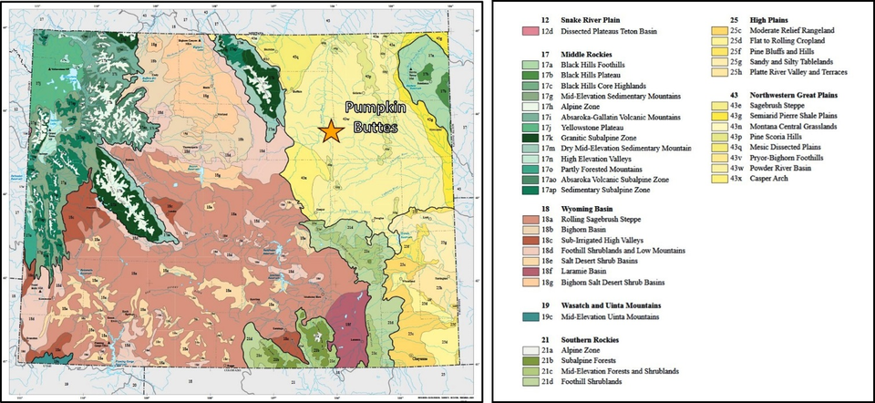
Ecoregions of Wyoming showing the Pumpkin Buttes area within the Powder River Basin ecoregion. The Powder River Basin ecoregion covers rolling prairie and dissected river breaks surrounding the Powder, Cheyenne, and upper North Platte rivers. The Powder River Basin has low precipitation and low available water. Mule deer, pronghorn antelope, and sage grouse share the plains with livestock. Oil, gas, and coal deposits are scattered throughout the ecoregion, and mining influences the character of the landscape. Roads and pipelines connect coalbed methane wells spaced 80 acres apart. Vast amounts of underground water reserves are pumped to the surface during coalbed methane production. The oil and gas production and mining create wealth and also conflicts over surface/subsurface property rights and water management in this semiarid region.
Image: After Chapman, S.S., Bryce, S.A., Omernik, J.M., Despain, D.G., ZumBerge, J., and Conrad, M., 2004, Ecoregions of Wyoming (color poster with map, descriptive text, summary tables, and photographs): Reston, Virginia, U.S. Geological Survey (map scale 1:1,400,00; http://ecologicalregions.info/data/wy/wy_front.pdf.
Image: After Chapman, S.S., Bryce, S.A., Omernik, J.M., Despain, D.G., ZumBerge, J., and Conrad, M., 2004, Ecoregions of Wyoming (color poster with map, descriptive text, summary tables, and photographs): Reston, Virginia, U.S. Geological Survey (map scale 1:1,400,00; http://ecologicalregions.info/data/wy/wy_front.pdf.
During Wyoming’s frontier period, the Pumpkin Buttes were used as an Indian lookout to monitor game, emigrant and soldier movements; a tribal ceremonial location; an outlaw hideout; and tactical high ground used in combat situations by Indians and U.S. Army soldiers. They are visible for miles, serving as an excellent topographic landmark.
The Powder River country was traditional Indian hunting territory. The 1851 Fort Laramie Treaty recognized Crow ownership of the land. The Sioux forcibly replaced the Crow by 1860. The Bozeman trail was created in 1863 to provide a shorter route from the Oregon Trail to the Montana gold fields. The Sioux, Arapaho and Cheyenne tribes objected to the emigrant traffic and Army posts erected on the hunting grounds. This trespassing of the Powder River hunting ground led to Red Cloud’s War (1866-1868) that ended with the abandonment of the trail and forts by the second Fort Laramie Treaty, 1868. Wyoming Territory was established in 1868.
The first non-native report of the Buttes is in a diary entry by missionary Pierre-Jean DeSmet, S.J. in 1851. He noted that the buttes, rising 1,000 feet above the surrounding plains, were a prominent landmark in the central Powder River Basin. Sioux Indians called them “Wa-ga-mu Pa-ha” meaning gourd hills. This was probably due to the abundant iron stone concretions found within sandstone of the Wasatch Formation along the flanks of the buttes. Gourds were commonly used in tribal spiritual ceremonies held in the area.
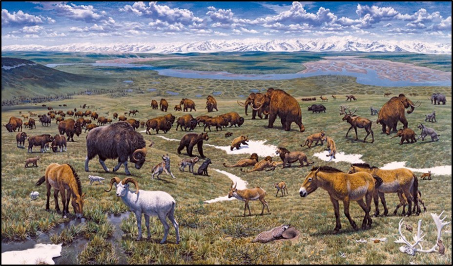
Upper: Pleistocene animals grazing on grass at the end of ice age landscape reconstruction.
Image: Mitka, N., 2017, Pleistocene Park Aims for Ice Age Rebirth: GearJunkie;
https://s3.amazonaws.com/images.gearjunkie.com/uploads/2017/04/Pleistocene-park-jurassic-park-of-today.jpg
Middle: Bison grazing on Durham Ranch. View is to the west.
Image: After https://durhambisonranch.com/the-ranch/.
Lower: Black Angus cattle grazing on Pumpkin Buttes Ranch.
Image: After https://beefchain.com/ranches/pumpkin-buttes-ranch/#gallery-1-2.
Portuguese fur trader Antonio Montero built a fur trade post on the banks of the South Fork, Powder River sometime between 1828 and 1834. This was one of the first attempts to establish trade with the Indians from a permanent structure in Wyoming. The venture failed due to its distance from a major trade, water or transportation route. It was also plagued by trouble from rival trappers, thieves and Indians. Mountain men Jim Bridger, Lucien Fontenelle, Kit Carson, Osbourn Russell, Joe Meek, Robert Newell and others of the fur company Fontenelle, Fitzpatrick, and Company spent the winter of 1837-1838 camped on the Powder River nearby causing mischief at Montero’s business. The post was abandoned in 1839.
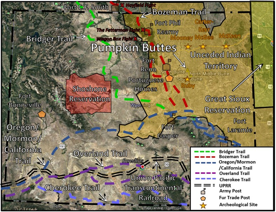
Wyoming frontier map. Location of Emigrant trails (1841-1868), the transcontinental railroad (1869) and Indian lands (1868). The three forts (1866-1868) established to protect the Bozeman Trail are shown by brown icons (C.F. Smith, Phil Kearny, Reno). Fur trade posts established about 1834 are shown by orange polygon. Indian territory is labeled, and archeological sites are shown by a gold star. Battle sites of Red Cloud’s War are marked by a red “x.”
Image: Google Earth base; features compiled by K. K. Steele.
Image: Google Earth base; features compiled by K. K. Steele.
Jim Bridger reported his inspection of the post some 20 years later:
"On September 26, 1859, after a ride of about fifteen miles, we came to the ruins of some old trading posts known as the 'Portuguese Houses,' from the fact that many years ago they were erected by a Portuguese trader named Antonio Mateo. They are now badly dilapidated and only one side of the pickets remains standing. These, however, are of hewn logs, and from their character it is evident that the structures were originally very strongly built. Bridger recounted a tradition that at one time this post was besieged by the Sioux for forty days, resisting successfully to the last, alike, the strength and the ingenuity of their assaults, and the appearance of the ruins renders the story not only credible, but also probable." (Bartlett, I.S., Editor, 1918, History of Wyoming, Chapter VII: The Fur Traders, p. 107; http://files.lib.byu.edu/mormonmigration/articles/historyofwyoming01bart.pdf).
"On September 26, 1859, after a ride of about fifteen miles, we came to the ruins of some old trading posts known as the 'Portuguese Houses,' from the fact that many years ago they were erected by a Portuguese trader named Antonio Mateo. They are now badly dilapidated and only one side of the pickets remains standing. These, however, are of hewn logs, and from their character it is evident that the structures were originally very strongly built. Bridger recounted a tradition that at one time this post was besieged by the Sioux for forty days, resisting successfully to the last, alike, the strength and the ingenuity of their assaults, and the appearance of the ruins renders the story not only credible, but also probable." (Bartlett, I.S., Editor, 1918, History of Wyoming, Chapter VII: The Fur Traders, p. 107; http://files.lib.byu.edu/mormonmigration/articles/historyofwyoming01bart.pdf).
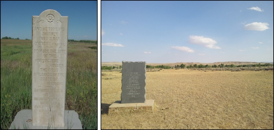
Left: Portuguese Houses marker, erected 1928 (also called the Portuguese Fort or Fort Antonio). Right: Fort Reno marker, erected, 1914. Fort Reno (originally Fort Conner), on the north bank of the Powder River, was the first erected and the last abandoned of the Bozeman Trail posts. No surface structures remain at either location. Both sites remain today as they were in the 19th century, isolated and remote.
Image: Left: Pierce, G., 2012, Negotiating the West: A History of Wyoming Trading Posts: Wyoming State Historic Preservation Office Planning and Historic Context Development Program Wyoming State Parks & Cultural Resource;https://wyoarchaeo.wyo.gov/DocsPDFs/Publications/Negotiating%20the%20West_Pierce.pdf; Right: https://upload.wikimedia.org/wikipedia/commons/9/97/Fort_Reno_and_Powder_River_near_Kaycee%2C_Wyoming.jpg.
Image: Left: Pierce, G., 2012, Negotiating the West: A History of Wyoming Trading Posts: Wyoming State Historic Preservation Office Planning and Historic Context Development Program Wyoming State Parks & Cultural Resource;https://wyoarchaeo.wyo.gov/DocsPDFs/Publications/Negotiating%20the%20West_Pierce.pdf; Right: https://upload.wikimedia.org/wikipedia/commons/9/97/Fort_Reno_and_Powder_River_near_Kaycee%2C_Wyoming.jpg.
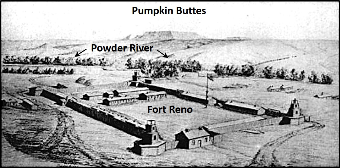
Drawing of Fort Reno with the Pumpkin Buttes in the background. View is to the southeast.
Image: After Schoborn, A., 1867, Fort Reno; http://www.fortwiki.com/Fort_Reno_(2).
Image: After Schoborn, A., 1867, Fort Reno; http://www.fortwiki.com/Fort_Reno_(2).
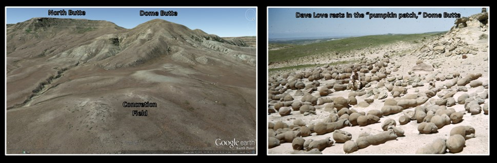
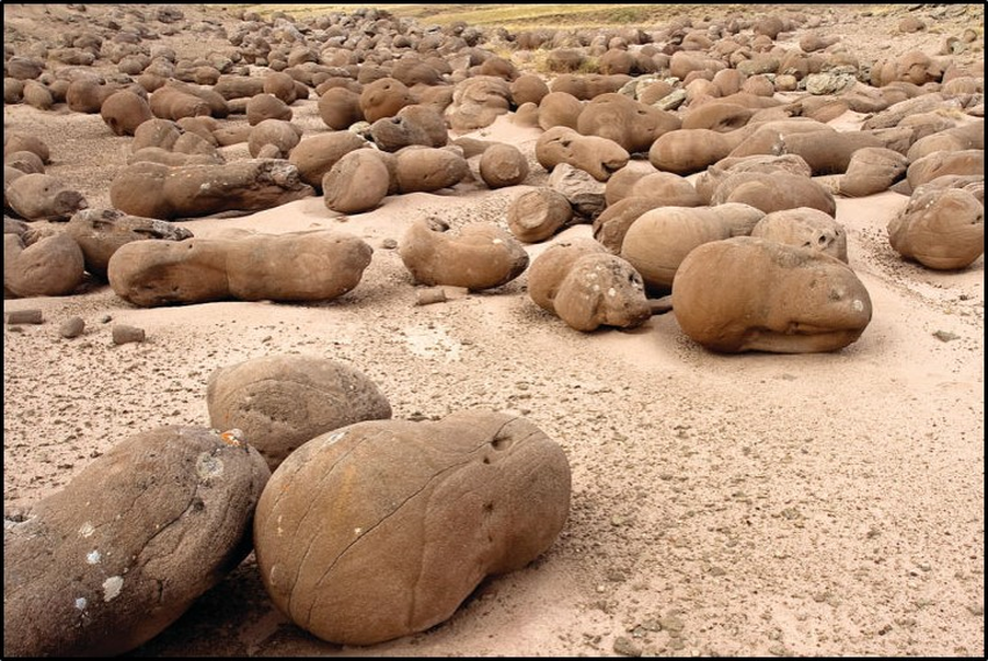
Pumpkin Buttes concretions, Wasatch Formation. Concretions are found on the flats surrounding the buttes. They consist of calcite cemented, iron-stained sandstone
Images: Left: Google Earth;
Right: https://www.sweetwaternow.com/cultural-geology-guide-pumpkin-buttes/;
Bottom: Mankin, J., 2011, Campbell County’s historic ranches: the Christensen Ranch: Gillette News Record; https://www.gillettenewsrecord.com/archives/article_e8dbd434-4b16-577f-becb-d3e34caf41f2.html.
In 1859, the Raynolds’ Expedition was the first government-sponsored exploration of the Powder River and Yellowstone country of Wyoming. The Corps of Topographical Engineers were mapping and exploring an area previously known only to native Americans and fur trappers and traders. The expedition visited the “Portuguese Houses” site location that was abandoned about twenty years earlier. J. Hudson Snowden, a team topographer, despairingly reported on the Pumpkin Buttes area:
“The whole of this region is barren and desolate, totally unfit for the uses of a civilized being – interesting to a geologist, and a splendid Indian country” (Snowden, J.H., Raynolds, 1859, Report on explorations from the Platte to the head-waters of the Shayenne, in W.F., Bvt. Brig. Gen., 1866, Report on the Exploration of the Yellowstone River, p. 161).
The survey expedition was guided by legendary mountain man Jim Bridger, and Ferdinand Vandeveer Hayden served as geologist. His geologic map of the survey was published in 1869 (see Hayden geologic map below).
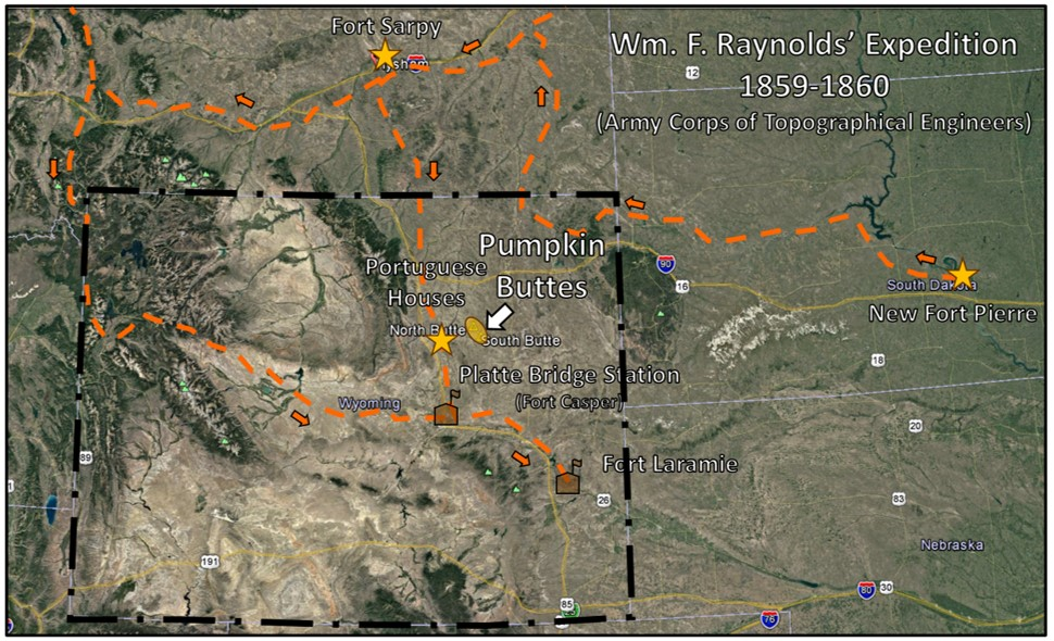
Raynolds’ 1859 scientific expedition of Pumpkin Buttes and Yellowstone region. Route of Raynolds expedition and detachments shown by orange dashed line. Fur Trading posts shown by gold stars.
Image: Google Earth base; features compiled by K. K. Steele.
Image: Google Earth base; features compiled by K. K. Steele.
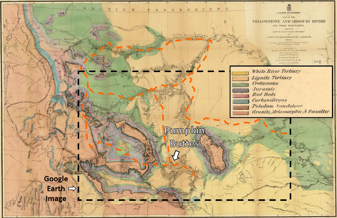
Hayden geologic map of Raynolds’ Expedition.
Image: After Hayden, F. V., 1869, Map of the Yellowstone and Missouri rivers and their tributaries, Retrieved from the Library of Congress; https://www.loc.gov/item/96682479/.
Image: After Hayden, F. V., 1869, Map of the Yellowstone and Missouri rivers and their tributaries, Retrieved from the Library of Congress; https://www.loc.gov/item/96682479/.
Geology of Pumpkin Buttes
The Pumpkin Buttes are erosional remnants of Tertiary basin fill that buried the mountains and extended to the Great Plains. They lie just east of the Powder River Basin structural axis on the west flank of a low-amplitude, north-plunging anticlinal nose. Basin fill consists of three Tertiary formations: Fort Union, Wasatch, and White River with only the Wasatch and White River outcropping in the Pumpkin Buttes area. The Tertiary strata were deposited primarily from northward flowing streams eroding the highlands surrounding the Powder River Basin and ash fall from Tertiary volcanism. Alluvial fans were deposited adjacent to the uplifts. Lakes and swamps dominated lowland areas during periods of subtropical climate in the Paleocene and produced abundant organic peat that generated the coal deposits. Groundwater transported oxidized uranium in solution through Wasatch channel sandstones and deposited ore where reducing conditions were encountered. Several organic rich marine beds generated petroleum after they were buried deep enough to reach optimum temperature and pressure: Paleozoic reservoirs – generation during the Cretaceous; Cretaceous reservoirs – generation during the Tertiary. Methane gas was generated by bacteria feeding on the coal beds: CBM – generation during the Cenozoic.
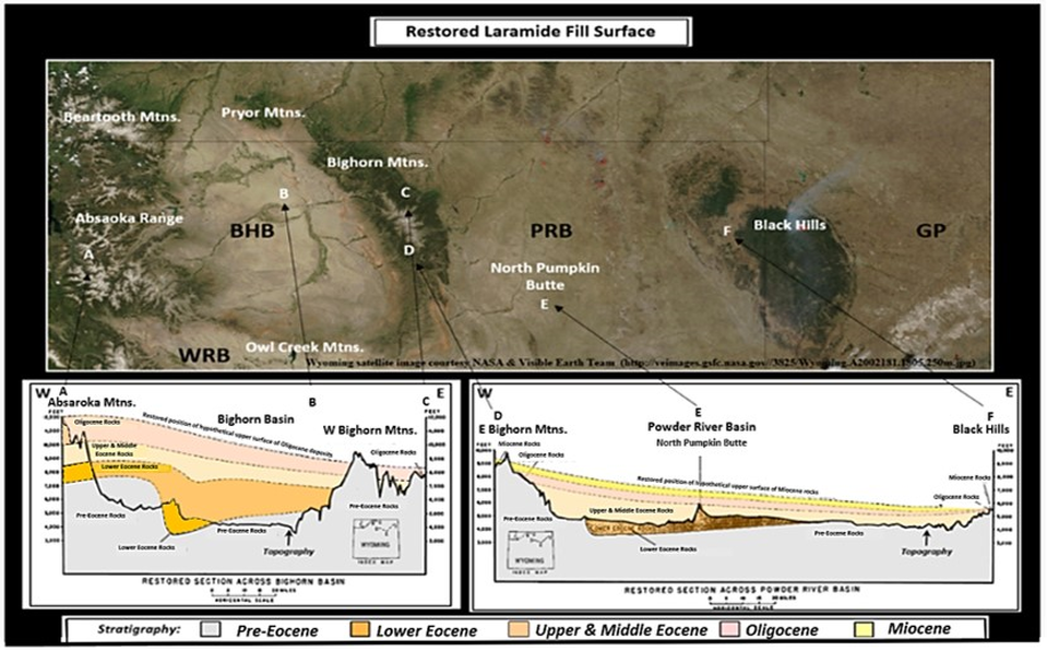
Restored Tertiary Laramide basin fill, Bighorn and Powder River basins. (Note smoke from a fire in the Black Hills.)
Image: Wyoming satellite image courtesy NASA & Visible Earth Team; https://visibleearth.nasa.gov/images/71527/montana-idaho-and-wyoming; Cross section: After McKenna, M.C. And Love, J.D., 1972, High-level Strata Containing Early Miocene Mammals on the Bighorn Mountains, Wyoming: American Museum of Natural History Novitates Number 2490, Fig. 2A-2B, p. 4-5;
http://digitallibrary.amnh.org/bitstream/handle/2246/2698//v2/dspace/ingest/pdfSource/nov/N2490.pdf?sequence=1&isAllowed=y
The anticlinal nose on the east side of the buttes gives a one degree northwest bed dip to Tertiary strata. The buttes lie near the drainage divide of the Powder, Belle Fourche, and Cheyenne rivers. The North Butte is the highest elevation point in the basin at 6,050 feet.
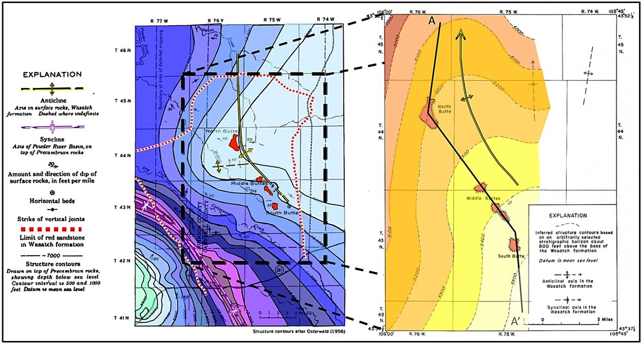
Left: Precambrian basement structure in Pumpkin Buttes area, Powder River Basin; Right: Generalized structure contour map of marker bed within the Eocene Wasatch Formation showing the four major Pumpkin Buttes. Location of cross section A-A’ shown.
Image: Left: After Sharp, W.N., McKay, E.J., McKeown, F.A., and White, A.M., 1964, Geology and uranium deposits of the Pumpkin Buttes area of the Powder River Basin, Wyoming: U.S. Geological Survey Bulletin 1107-H, Fig. 87, p. 550; https://pubs.usgs.gov/bul/1107h/report.pdf;
Right: After Troyer, M.L., McKay, E.J., Soister, P.E., and Wallace, S.R., 1954, Summary of Investigations of Uranium Deposits in the Pumpkin Buttes Area, Johnson and Campbell Counties, Wyoming: U.S. Geological Survey Circular 338, Fig. 2, p. 3; https://pubs.usgs.gov/circ/0338/report.pdf.
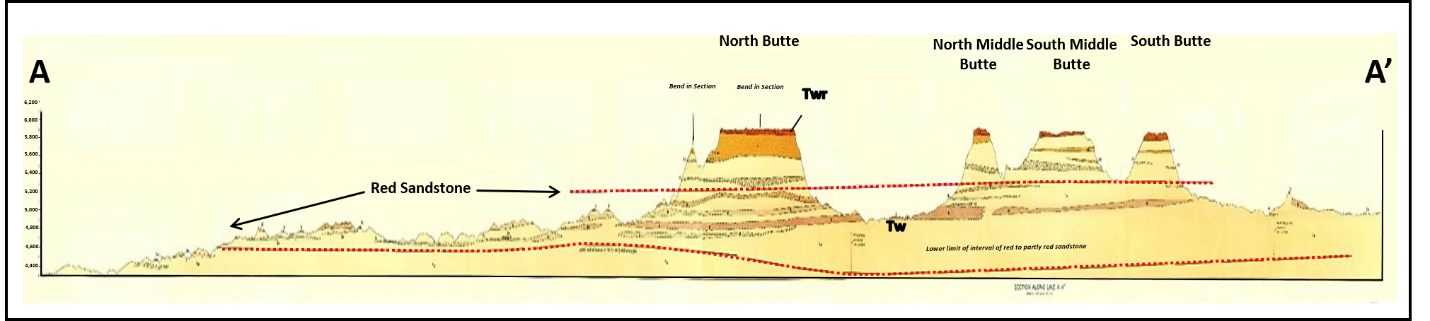
Generalized geologic cross section Pumpkin Buttes area. Location of north to south cross section shown on Wasatch structure map (above right). Formation abbreviations: Twr – Oligocene White River Formation; Tw – Eocene Wasatch Formation. Beds are nearly flat lying in the area.
Image: After Sharp, W.N., McKay, E.J., McKeown, F.A., and White, A.M., 1964, Geology and uranium deposits of the Pumpkin Buttes area of the Powder River Basin, Wyoming: U.S. Geological Survey Bulletin 1107-H, Plate 12, Cross section A-A’; https://pubs.usgs.gov/bul/1107h/report.pdf.
Image: After Sharp, W.N., McKay, E.J., McKeown, F.A., and White, A.M., 1964, Geology and uranium deposits of the Pumpkin Buttes area of the Powder River Basin, Wyoming: U.S. Geological Survey Bulletin 1107-H, Plate 12, Cross section A-A’; https://pubs.usgs.gov/bul/1107h/report.pdf.
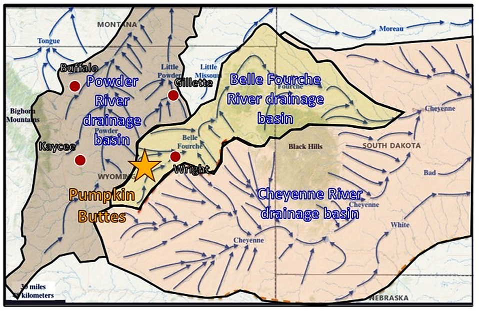
Pumpkin Buttes near triple stream drainage divide.
Image: After Clausen, E., 2018, Belle Fourche River-Cheyenne River Drainage Divide Area in the Wyoming Powder River Basin Analyzed by Topographic Map Interpretation Methods, USA: Journal of Geography and Geology; Vol. 10, No. 2; Fig. 1, p. 3; https://www.researchgate.net/publication/323697830_Belle_Fourche_River-Cheyenne_River_Drainage_Divide_Area_in_the_Wyoming_Powder_River_Basin_Analyzed_by_Topographic_Map_Interpretation_Methods_USA.
Image: After Clausen, E., 2018, Belle Fourche River-Cheyenne River Drainage Divide Area in the Wyoming Powder River Basin Analyzed by Topographic Map Interpretation Methods, USA: Journal of Geography and Geology; Vol. 10, No. 2; Fig. 1, p. 3; https://www.researchgate.net/publication/323697830_Belle_Fourche_River-Cheyenne_River_Drainage_Divide_Area_in_the_Wyoming_Powder_River_Basin_Analyzed_by_Topographic_Map_Interpretation_Methods_USA.
The Oligocene White River Formation is the capstone on the buttes. It is 30-50 feet thick and consists of coarse-grained sandstone, volcanic ash deposits (tuff) and bentonitic claystone (swelling clay). Outcrops of White River and similar age lithologies are found near the crest of the Bighorn Mountains and on mesas in the Black Hills, South Dakota, and the badlands, Nebraska. The unit unconformably lies on the Wasatch Formation that becomes progressively older to the south.
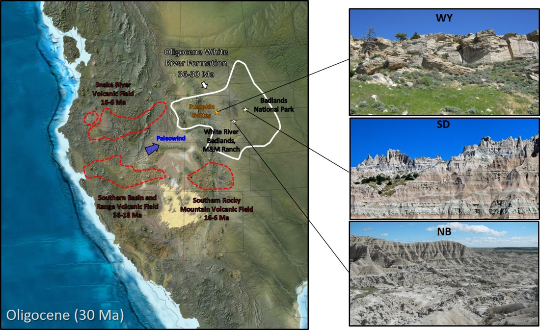
Probable source location of White River Formation volcanic ash in the southern Basin and Range volcanic field. The ash bed origin of uranium in the Wasatch Formation, along with the roll front model, were established at Pumpkin Buttes. WY = Wyoming, SD = South Dakota and NB = Nebraska
Image: Left Base: After Blakey, R.C., 2013, Using Paleogeographic Maps to Portray Phanerozoic Geologic and Paleotectonic History of Western North America: American Association of Petroleum Geologists Search and Discovery Article #30267; http://www.searchanddiscovery.com/documents/2013/30267blakey/ndx_blakey.pdf;
Left Data: After Aslan, A., Marisa Boraas-Connors, M., Sprinkel, D.A., Becker, T.P., Lynds, R., Karlstrom, K.E., and Heizler, M., 2017, Cenozoic collapse of the eastern Uinta Mountains and drainage evolution of the Uinta Mountains region: Geological Society of America Geosphere, Vol. 14, No. 1, Fig. 13, p. 132; https://www.researchgate.net/publication/321231712_Cenozoic_collapse_of_the_eastern_Uinta_Mountains_and_drainage_evolution_of_the_Uinta_Mountains_region;
Right Top: After https://www.adventuresoflupe.com/?paged=2&tag=wyoming;
Right Middle: https://upload.wikimedia.org/wikipedia/commons/9/97/White_River_Badlands_of_South_Dakota_panorama.jpg;
Right Bottom: http://phatfossils.com/White%20River%20Badlands.php.
The Eocene Wasatch Formation is about 1,600 feet of claystone, siltstone fine and coarse sandstone units with coal beds. Cross bedding within the sand units indicates deposition in north flowing streams. Channel sands are characteristically red stained and contain calcite cemented concretions along the flanks of the Pumpkin Buttes. The sands make up one third of the formation and the remainder consist of flood plain deposits.
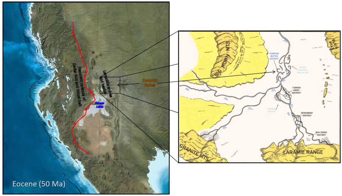
Wasatch Formation paleogeographic maps, middle to late Eocene. Prevailing north stream flow and channel development in Pumpkin Buttes area are shown.
Image: Left: Blakey, R.C., 2013, Using Paleogeographic Maps to Portray Phanerozoic Geologic and Paleotectonic History of Western North America: American Association of Petroleum Geologists Search and Discovery Article #30267; http://www.searchanddiscovery.com/documents/2013/30267blakey/ndx_blakey.pdf;
Right: After Uranerz Energy Corporation, 2014, Nichols Ranch ISR Project U.S.N.R.C Source Material
SUA- 1597 Jane Dough Amendment Volume VI, APPENDIX JD-D5: Geology, Fig. JD-D5-1a, Map Pocket; https://www.nrc.gov/docs/ML1416/ML14164A355.pdf.
The Paleocene Fort Union Formation in the subsurface at Pumpkin Buttes is 2,800-3,000 feet thick. The lithologies are like the Wasatch but generally have a drabber color. Rocks include gray to buff fine- to coarse-grained lenticular sandstone, shale, and coal beds developed from buried peat mires (swampy ground).
Fort Union Formation paleogeographic maps. Distribution of coal swamps (mires) and major streams are displayed.
Image: Left: Blakey, R.C., 2013, Using Paleogeographic Maps to Portray Phanerozoic Geologic and Paleotectonic History of Western North America: American Association of Petroleum Geologists Search and Discovery Article #30267; http://www.searchanddiscovery.com/documents/2013/30267blakey/ndx_blakey.pdf; Right: After Johnson, R.C., Birdwell, J.E., Mercier, T.J., and Brownfield, M.E., 2016, Geology of tight oil and potential tight oil reservoirs in the lower part of the Green River Formation, Uinta, Piceance, and Greater Green River Basins, Utah, Colorado, and Wyoming: U.S. Geological Survey Scientific Investigations Report 2016–5008, Fig. 4, p. 7; https://www.researchgate.net/publication/302497905_Geology_of_tight_oil_and_potential_tight_oil_reservoirs_in_the_lower_part_of_the_Green_River_Formation_Uinta_Piceance_and_Greater_Green_River_Basins_Utah_Colorado_and_Wyoming.
Image: Left: Blakey, R.C., 2013, Using Paleogeographic Maps to Portray Phanerozoic Geologic and Paleotectonic History of Western North America: American Association of Petroleum Geologists Search and Discovery Article #30267; http://www.searchanddiscovery.com/documents/2013/30267blakey/ndx_blakey.pdf; Right: After Johnson, R.C., Birdwell, J.E., Mercier, T.J., and Brownfield, M.E., 2016, Geology of tight oil and potential tight oil reservoirs in the lower part of the Green River Formation, Uinta, Piceance, and Greater Green River Basins, Utah, Colorado, and Wyoming: U.S. Geological Survey Scientific Investigations Report 2016–5008, Fig. 4, p. 7; https://www.researchgate.net/publication/302497905_Geology_of_tight_oil_and_potential_tight_oil_reservoirs_in_the_lower_part_of_the_Green_River_Formation_Uinta_Piceance_and_Greater_Green_River_Basins_Utah_Colorado_and_Wyoming.
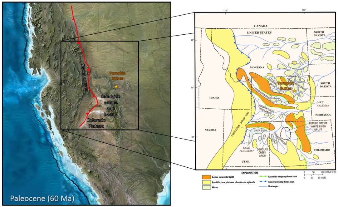
Underlying the 4,000 to 6,000 feet of sedimentary rocks of Tertiary age is a complex interfingering 7,000-foot package of Cretaceous sandstones, siltstones and shales deposited within and marginal to the Western Interior Seaway. Beneath the Cretaceous rocks lie 1,100 feet of Jurassic and Triassic rocks. These units record the fluvial Morrison sediments shed from the rising Sevier Mountains, the marine deposits of the interior Sundance Seaway, and the Triassic red beds deposited during the last 80 million years of the supercontinent Pangea.
Pangea began to form 335 million years ago during deposition of the Madison Limestone when Gondwana collided with North America (Laurasia) and the Ouachita-Marathon-Sonora and Ancestral Rocky Mountains rose. The underlying passive margin marine sedimentation began in Wyoming 520 million years ago with the Middle Cambrian Flathead formation along the western margin of North America. The passive margin (tectonically quiet) developed after the breakup of the supercontinent Rodinia about 750 million years ago. The Paleozoic strata consist of 2,000 feet of predominately marine carbonate rocks. The total thickness of sedimentary rocks overlying Precambrian crystalline rocks in the Powder River Basin is about 16,000 feet.
Pangea began to form 335 million years ago during deposition of the Madison Limestone when Gondwana collided with North America (Laurasia) and the Ouachita-Marathon-Sonora and Ancestral Rocky Mountains rose. The underlying passive margin marine sedimentation began in Wyoming 520 million years ago with the Middle Cambrian Flathead formation along the western margin of North America. The passive margin (tectonically quiet) developed after the breakup of the supercontinent Rodinia about 750 million years ago. The Paleozoic strata consist of 2,000 feet of predominately marine carbonate rocks. The total thickness of sedimentary rocks overlying Precambrian crystalline rocks in the Powder River Basin is about 16,000 feet.

Paleogeography of Pre-Tertiary strata. The Pumpkin Buttes area deposition was predominately marine during this time, with a progressive shift from carbonate to clastic rocks in the Mesozoic.
Image: After Blakey, R.C., 2013, Using Paleogeographic Maps to Portray Phanerozoic Geologic and Paleotectonic History of Western North America: American Association of Petroleum Geologists Search and Discovery Article #30267; http://www.searchanddiscovery.com/documents/2013/30267blakey/ndx_blakey.pdf.
Image: After Blakey, R.C., 2013, Using Paleogeographic Maps to Portray Phanerozoic Geologic and Paleotectonic History of Western North America: American Association of Petroleum Geologists Search and Discovery Article #30267; http://www.searchanddiscovery.com/documents/2013/30267blakey/ndx_blakey.pdf.
Natural Resources in Pumpkin Buttes Area
The Pumpkin Buttes region is rich with energy resources. Traditionally the area produced coal, petroleum and uranium.
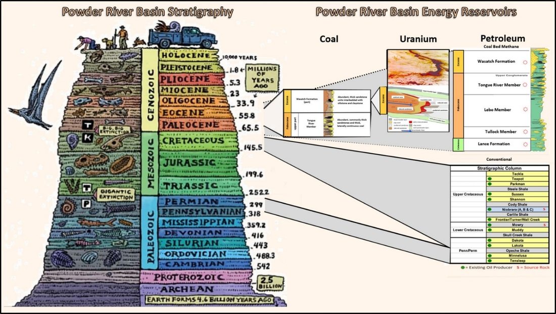
Powder River Basin Stratigraphy showing energy resources host rocks.
Image: PRB Stratigraphic Column: After Reppe, C. and Stefanović, V.M., 2015, Applications in Geochemistry, Geophysics and Petrophysics for the Exploration and Production of the Niobrara Formation in the Powder River Basin and Adjacent Areas: WGA/SPE Presentation, Slide 7; https://www.slideshare.net/CalvinReppe/wgaspe-abbrevated-presentation1302015;
Coal: After Hinaman, K.,2005, Hydrogeologic Framework and Estimates of Ground-Water Volumes in Tertiary and Upper Cretaceous Hydrologic Units in the Powder River Basin: U.S. Geological Survey Scientific Investigations Report 2005-5008, Fig. 2, p. 4; https://pubs.usgs.gov/sir/2005/5008/pdf/sir20055008.pdf;
Uranium: After Susan A. Cumberland, S.A., Douglas, G., Grice, K., Moreau, J.W., 2016, Uranium mobility in organic matter-rich sediments: A review of geological and geochemical processes: Earth-Science Reviews 159, Fig. 1, p. 177; https://www.researchgate.net/publication/303636362_Uranium_mobility_in_organic_matter-rich_sediments_A_review_of_geological_and_geochemical_processes;
CBM: After Trippi, M.H., Stricker, G.D., Flores, R.M., Stanton, R.W., Chiehowsky, L.A., and Moore, T.A., 2010, Megascopic lithologic studies of coals in the Powder River basin in Wyoming and in adjacent basins in Wyoming and North Dakota: U.S. Geological Survey Open-File Report 2010–1114, Fig. 2, p. 3; https://pubs.usgs.gov/of/2010/1114/pdf/OFR_2010-1114.pdf;
Conventional: https://www.oilandgas360.com/powder-river-power-play-two-prb-wells-set-records-for-anschutz-exploration/
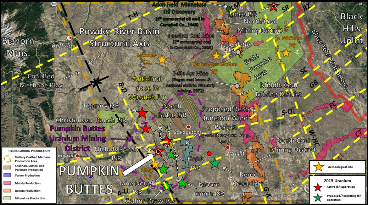
Tectonic trends, energy resources and archeological sites in the Pumpkin Buttes area. Third quarter 2019 active ISR mines shown by red star with black dot. Lineament abbreviations (yellow dashed lines): A-U – Armento-Upton; BC – Bell Creek; B-D – Buffalo-Douglas; CT - Clareton; FC – Fiddler Creek; GB – Gose Butte; GK – Gillette-Keyline; LM – Little Missouri; RZ - Rozet; SC – South Coyote Creek; S-O – Sussex-Osage; SR – Springen Ranch; T-H – Tensleep -Harding; W-HC – Weston-Hat Creek.
Image: Google Earth
Image: Google Earth
Coal and Clinker in Pumpkin Buttes Area
Coal was mined for local consumption at the beginning of the 20th century, and probably earlier by native people. Small scale underground mining operations (1918-1925) were initiated by Peerless Mine near Gillette. Wyodak Company began the world’s first surface coal mine near Peerless operations in 1924. Major coal operations began in the 1970s with the opening of the Belle Ayr strip mine. This mine marked a national shift from eastern bituminous coal to Powder River Basin subbituminous, low sulfur coal for power generation. The Powder River coal fields production peaked in 2018 and has declined since due to competition from natural gas, wind and solar. Several coal companies have filed for bankruptcy since 2015. The coal beds are found in the upper Fort Union and lower Wasatch Formations. Wyoming holds one third of the nation’s recoverable coal reserves. Clinker beds mark the updip limit of minable coal beds.
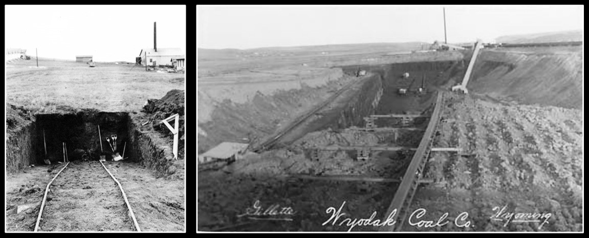
Left: Slope shaft at Peerless Mine, 1918-1925; Right: country's first and oldest open pit coal mine, Wyodak, undated.
Image: Left: https://www.wyohistory.org/encyclopedia/campbell-county-wyoming;
Right: Wyoming State Archives, Department of State Parks and Cultural Resources; http://spcrphotocollection.wyo.gov/luna/servlet/detail/SPCRACV~3~3~1109689~139815?qvq=q%3Awyodak%3Bsort%3Atitle_or_file&mi=2&trs=29.
Image: Left: https://www.wyohistory.org/encyclopedia/campbell-county-wyoming;
Right: Wyoming State Archives, Department of State Parks and Cultural Resources; http://spcrphotocollection.wyo.gov/luna/servlet/detail/SPCRACV~3~3~1109689~139815?qvq=q%3Awyodak%3Bsort%3Atitle_or_file&mi=2&trs=29.
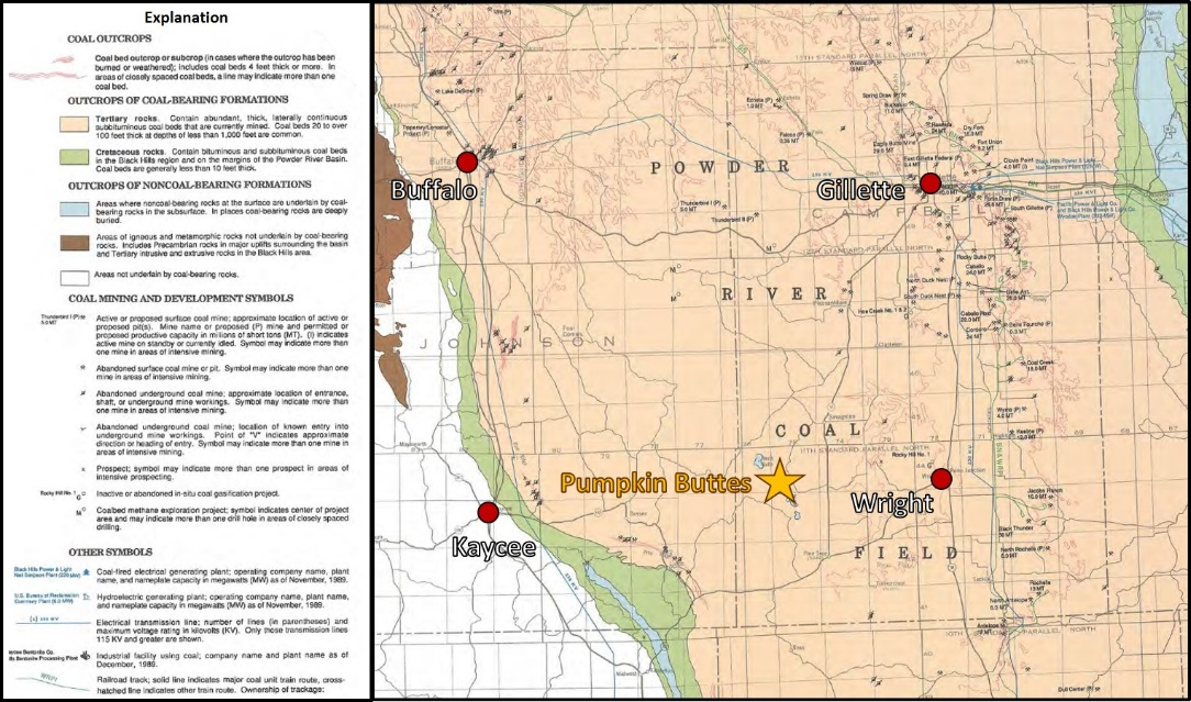
Pumpkin Buttes area coal.
Image: After Jones, R.W., 1990, Coal Map of the Powder River Basin and Adjacent Areas, Wyoming: Wyoming State Geological Survey Map Series 33 Powder River Basin Coal Map; https://www.wsgs.wyo.gov/products/wsgs-1990-ms-33.pdf.
Image: After Jones, R.W., 1990, Coal Map of the Powder River Basin and Adjacent Areas, Wyoming: Wyoming State Geological Survey Map Series 33 Powder River Basin Coal Map; https://www.wsgs.wyo.gov/products/wsgs-1990-ms-33.pdf.
The abundant clinker outcrops surrounding the basin were formed by coal-bed fires that burned over several millions of years. The heat bakes and partially melts the overlying strata into a brick-red, resistant rock called clinker. Totally melted and recrystallized portions of the overlying beds are called paralava (a coal-fired metamorphosed rock). Like lava, paralava can flow and migrate into fractures and vents in the host rock. The oldest fission track date from an in-place sample is 2.8 + 0.6 million years. Resistant clinker beds control the outcrop topography in the Tongue River Member of the Paleocene Fort Union Formation and the lower part of the Eocene Wasatch Formation. Clinker covers 1,580 square miles in the Powder River Basin accounting for 7 percent of the surface area. The high silica zones within clinker form a distinctive ceramic-like rock (porcellanite) that was used for tools and weapons by hunter-gatherers for thousands of years. Today clinker is mined for aggregate for railroad track ballast and road construction.
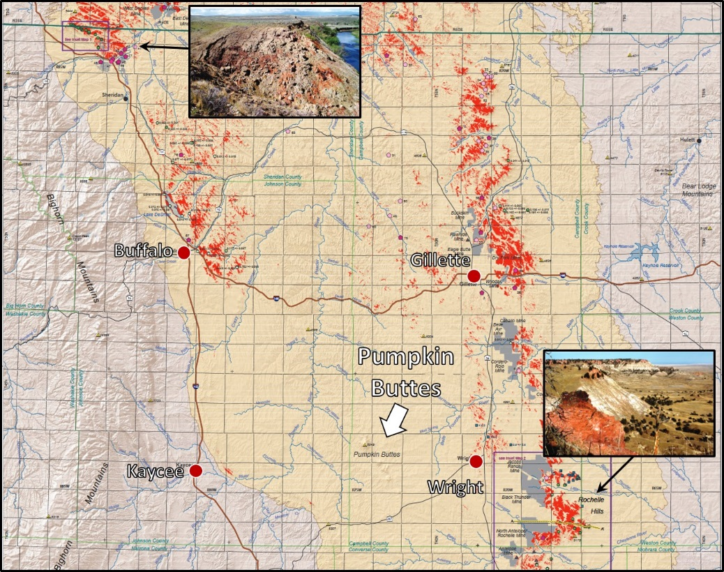
Pumpkin Buttes area Clinker outcrops, Powder River Basin.
Image: Base: Heffern, E.L., Reiners, P.W., Riihimaki, C.A., 2013, Clinker Distribution and Age in the Powder River Structural Basin: Montana Bureau of Mines and Geology Geologic Map 64; Plate 1; http://www.mbmg.mtech.edu/pdf-publications/gm64.pdf; Photos: Heffern, E.L., Reiners, P.W., Naeser, C.W., and Coates, D.A., 2007, Geochronology of clinker and implications for evolution of the Powder River Basin landscape, Wyoming and Montana, in Stracher, G.B., ed., Geology of Coal Fires: Case Studies from Around the World: Geological Society of America Reviews Engineering Geology, v. XVIII, Fig. 2, p. 159; https://www.geo.arizona.edu/~reiners/Heffernetal2008.pdf.
Image: Base: Heffern, E.L., Reiners, P.W., Riihimaki, C.A., 2013, Clinker Distribution and Age in the Powder River Structural Basin: Montana Bureau of Mines and Geology Geologic Map 64; Plate 1; http://www.mbmg.mtech.edu/pdf-publications/gm64.pdf; Photos: Heffern, E.L., Reiners, P.W., Naeser, C.W., and Coates, D.A., 2007, Geochronology of clinker and implications for evolution of the Powder River Basin landscape, Wyoming and Montana, in Stracher, G.B., ed., Geology of Coal Fires: Case Studies from Around the World: Geological Society of America Reviews Engineering Geology, v. XVIII, Fig. 2, p. 159; https://www.geo.arizona.edu/~reiners/Heffernetal2008.pdf.
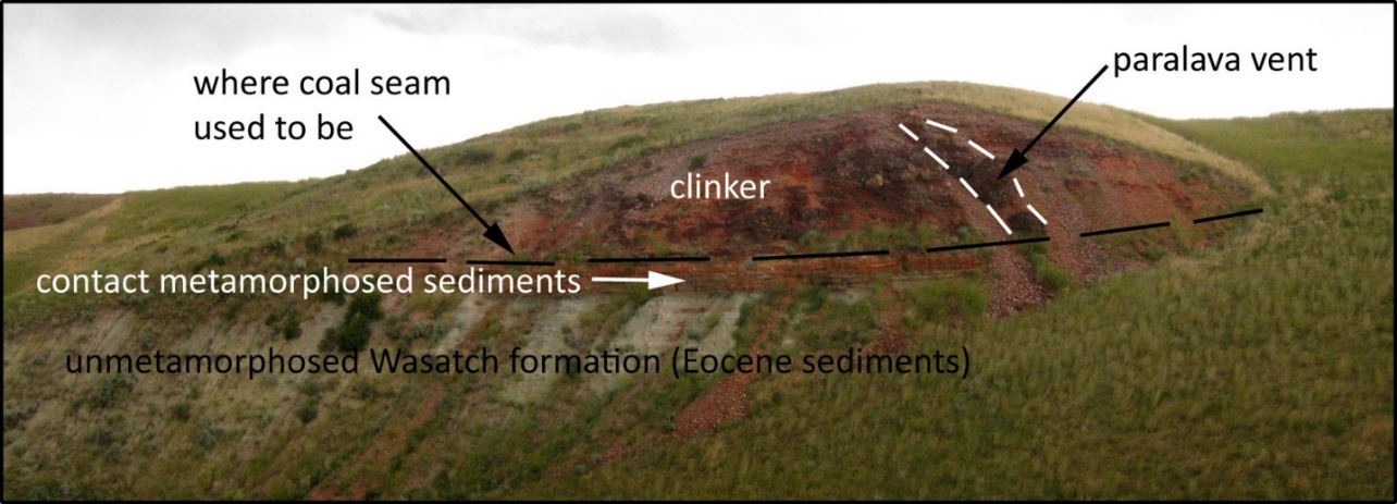
Outcrop of coal-bed fire altered rock, Powder River Basin. Paralava vent on right side of photo formed where a fracture network extended to the surface. The coal fire metamorphosed vent of paralava cross cuts the clinker on right side of image.
Image: Bentley, C., 2011, Clinker: Mountain Beltway; https://blogs.agu.org/mountainbeltway/files/2011/09/IMG_6530_anno.jpg.
Image: Bentley, C., 2011, Clinker: Mountain Beltway; https://blogs.agu.org/mountainbeltway/files/2011/09/IMG_6530_anno.jpg.
Oil and Gas in Pumpkin Buttes Area
The first petroleum boom in the Powder River Basin began with the discovery of Salt Creek field 34 miles southwest of Pumpkin Buttes along the Casper Arch in 1908. The first commercial oil discovery in the Pumpkin Buttes area was the Pennsylvanian Minnelusa oil reservoir in 1948 at Adon Field north of Gillette. Conventional reservoirs in the area range in age from Mississippian to Paleocene. Wyoming holds three percent of the nation’s proved crude oil reserve. Unconventional coal bed methane (CBM) plays began in the 1990s in the Tertiary coals with the drilling boom lasting from 1998 to 2008. Wyoming was the nation’s third largest CBM producer. The majority of the CBM wells have now been plugged, idled or orphaned because of depletion and low natural gas prices. In 2010’s the industry began to focus on horizontal drilling and fracking oil and gas Cretaceous sandstones of the Teapot, Parkman, Sussex, Shannon, and Frontier/Turner and source rocks of the Niobrara and Mowry Formations.

Left: Adon Field, Campbell County, Wyoming; Right: CBM wells in Powder River Basin.
Image: Left: After Porkorny, H.D., 1981, Adon Field: Wyoming Oil and Gas Fields Symposium, Powder River Basin, Figure on p. 2;
Right: https://www.wyofile.com/wp-content/uploads/2015/03/cbm_drillingroads.jpg.
Image: Left: After Porkorny, H.D., 1981, Adon Field: Wyoming Oil and Gas Fields Symposium, Powder River Basin, Figure on p. 2;
Right: https://www.wyofile.com/wp-content/uploads/2015/03/cbm_drillingroads.jpg.
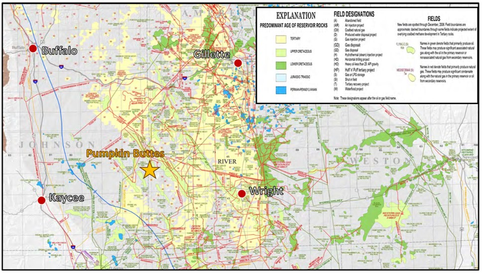
Pumpkin Buttes area conventional oil and gas fields and coalbed methane fields.
Image: After DeBruin, R.H., 2007, Oil and Gas Fields Map of the Powder River Basin, Wyoming, Wyoming State Geological Survey Map Series 51 Powder River Basin oil and gas map; https://www.wsgs.wyo.gov/products/wsgs-2007-ms-51.pdf
Image: After DeBruin, R.H., 2007, Oil and Gas Fields Map of the Powder River Basin, Wyoming, Wyoming State Geological Survey Map Series 51 Powder River Basin oil and gas map; https://www.wsgs.wyo.gov/products/wsgs-2007-ms-51.pdf
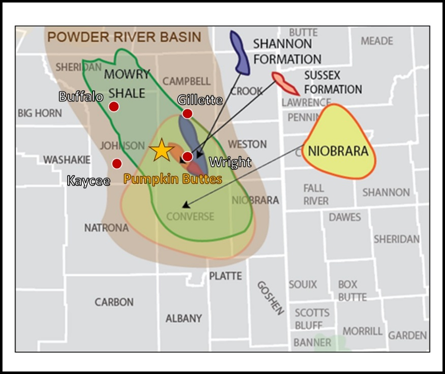
Pumpkin Buttes area shale and sandstone resource petroleum play.
Image: After Beets, J., 2016, Niobrara play.ppt: SlideShare; https://www.slideshare.net/JerryBeets/niobrara-playppt-69364203
Image: After Beets, J., 2016, Niobrara play.ppt: SlideShare; https://www.slideshare.net/JerryBeets/niobrara-playppt-69364203
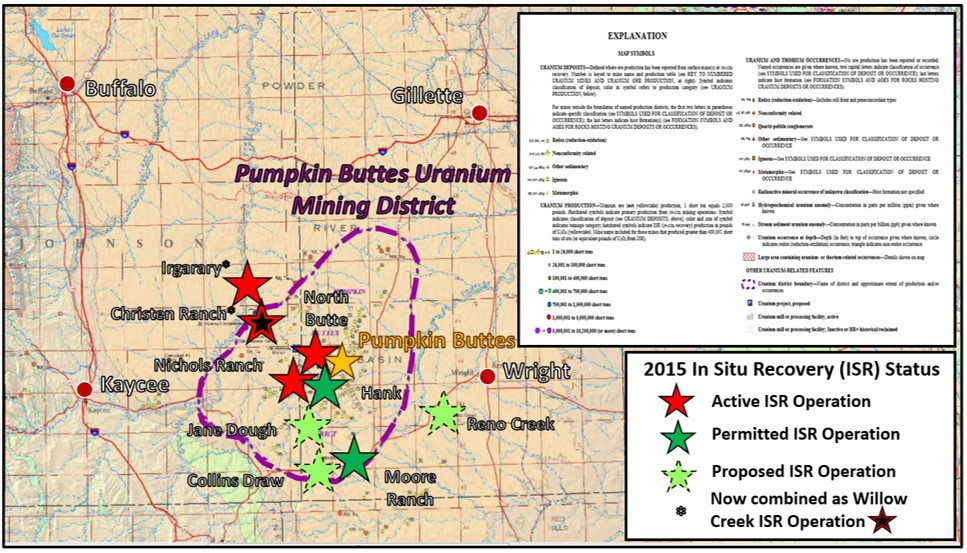
Uranium in Pumpkin Butte Area
Uranium was discovered at Pumpkin Buttes in 1951. The ore bodies are within and adjacent to red stained channeled sandstones at redox roll fronts in the Wasatch Formation. Jenkins & Hand shipped the first 17,000 tons of ore from the Powder River Basin to Edgerton, SD in 1953. The ore came from many surface deposits that were outside the Atomic Energy Commission withdrawal zone at Pumpkin Buttes. Originally the only uranium market was with the Federal Government that used uranium in cold war armaments. The first commercial nuclear power plant in the United States was opened in 1958. Wyoming operators have used only the in situ recovery (ISR)
mining technique since 1993 (see https://www.geowyo.com/gas-hills--crooks-gap-uranium.html). Since Three Mile Island, 1979, Chernobyl, 1986, and Fukushima Daiichi, 2011 nuclear accidents there is increasing resistance to nuclear power generation. Currently there are 58 commercially operating nuclear power plants with 96 nuclear reactors in 29 U.S. states, the majority located east of the Mississippi River. In 2015, there were five ISR Projects operating in the Powder River Basin, with several additional in the permitting and planning stages. Today only two sites remain active in the area: Nichols Ranch and Lance ISR projects. Several ISR projects in the Pumpkin Buttes area have been suspended and/or delayed due to market forces. Wyoming holds the nation’s largest known reserves of any state. The reserves ranged from 539-1,227 million pounds depending on price in a 2008 estimate.
mining technique since 1993 (see https://www.geowyo.com/gas-hills--crooks-gap-uranium.html). Since Three Mile Island, 1979, Chernobyl, 1986, and Fukushima Daiichi, 2011 nuclear accidents there is increasing resistance to nuclear power generation. Currently there are 58 commercially operating nuclear power plants with 96 nuclear reactors in 29 U.S. states, the majority located east of the Mississippi River. In 2015, there were five ISR Projects operating in the Powder River Basin, with several additional in the permitting and planning stages. Today only two sites remain active in the area: Nichols Ranch and Lance ISR projects. Several ISR projects in the Pumpkin Buttes area have been suspended and/or delayed due to market forces. Wyoming holds the nation’s largest known reserves of any state. The reserves ranged from 539-1,227 million pounds depending on price in a 2008 estimate.

Left: First uranium deposit found in Wyoming. Sandstone roll in Wasatch formation on south face of North Pumpkin Butte.
Right: Roll front model originated from Pumpkin Buttes outcrops.
Image: Left: Mrak, V.A., 1958, Uranium Deposits in the Tertiary Sediments of the Powder River Basin, Wyoming: Wyoming Geological Association 13th Annual Field Conference Guidebook, Fig. on p. 240 Right: After Uranerz Energy Corporation , 2014, Nichols Ranch ISR Project U.S.N.R.C. Source Material SUA-1597 Jane Dough Amendment, Vol. VI, Appendix JD-D5, Fig. JD-D5-a, Map Pocket; https://www.nrc.gov/docs/ML1416/ML14164A355.pdf ; Beahm, D., 2006, Moore Ranch Uranium Project Campbell County, Wyoming, USA: 43-101 Mineral Resource Report; https://www.sec.gov/Archives/edgar/data/1361605/000106299306002507/exhibit99-6.htm.
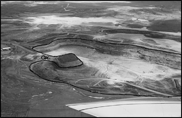
Aerial View of Highland open pit uranium mine, southern Powder River Basin. The pit outlines a plan view of an ore roll, with an oxidation tongue extending into it from the left.
Image: Hobday, D.K. and Galloway, W.E., 1999, Groundwater processes and sedimentary uranium deposits: Hydrogeology Journal Vol. 7, Fig. 4, p. 130; https://www.researchgate.net/publication/226115777_Groundwater_processes_and_sedimentary_uranium_deposits
Image: Hobday, D.K. and Galloway, W.E., 1999, Groundwater processes and sedimentary uranium deposits: Hydrogeology Journal Vol. 7, Fig. 4, p. 130; https://www.researchgate.net/publication/226115777_Groundwater_processes_and_sedimentary_uranium_deposits

Nichols Ranch In Situ Recovery uranium project, southern Powder River Basin.
Image: Uranerz Energy Corporation, 2011 Annual Report; http://www.annualreports.com/HostedData/AnnualReportArchive/u/TSX_URZ_2011.pdf
Image: Uranerz Energy Corporation, 2011 Annual Report; http://www.annualreports.com/HostedData/AnnualReportArchive/u/TSX_URZ_2011.pdf
Pumpkin Buttes area uranium.
Image: After Gregory, R.W., Jones, R.W., and Cottingham, K.D., 2010, Uranium Map of Wyoming: Wyoming State Geological Survey Map Series 94 Uranium Map of Wyoming Version 1.0; https://www.wsgs.wyo.gov/products/wsgs-2009-ms-94.pdf.
Image: After Gregory, R.W., Jones, R.W., and Cottingham, K.D., 2010, Uranium Map of Wyoming: Wyoming State Geological Survey Map Series 94 Uranium Map of Wyoming Version 1.0; https://www.wsgs.wyo.gov/products/wsgs-2009-ms-94.pdf.
Wind in Pumpkin Buttes Area
Recognition of the area’s wind potential led to the Reno Wind project proposal in 2011. The project did not move forward, and the project permit expired in 2013. Wyoming is one of the country's windiest states and has the potential to generate 883 million megawatt-hours per year (MWh/y) from wind power.
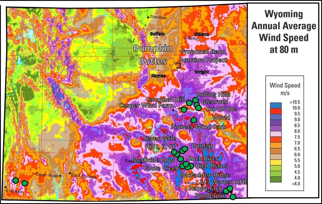
Pumpkin Buttes wind potential. Wind farms: active – green dot; proposed – orange dot.
Image: After National Renewable Energy Laboratory, 2010, Wyoming 80-Meter Wind Resource Map; https://windexchange.energy.gov/files/u/visualization/pdf/wy_80m.pdf.
Image: After National Renewable Energy Laboratory, 2010, Wyoming 80-Meter Wind Resource Map; https://windexchange.energy.gov/files/u/visualization/pdf/wy_80m.pdf.
Solar in Pumpkin Buttes Area
Wyoming has tremendous solar resource, but scant power generation. The state has only one utility scale solar farm near Green River approved in 2018. The legislature has a 25 kilowatt net metering limit and offers no renewable energy credits to incentivize solar customers. There has been no utility scale project proposed in the Pumpkin Buttes area despite the potential. Wyoming ranks 11th in the nation for potential solar generation, according to the National Renewable Energy Laboratory. Solar power in Wyoming has the potential to generate 72 million megawatt-hours per year (MWh/y).
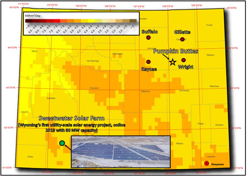
Pumpkin Buttes solar potential.
Image: After National Renewable Energy Laboratory, 2017, Global Solar Radiation at Latitude Tilt – Annual;http://www.mysolarpower.info/map_large_pv_WY.jpg.
Image: After National Renewable Energy Laboratory, 2017, Global Solar Radiation at Latitude Tilt – Annual;http://www.mysolarpower.info/map_large_pv_WY.jpg.

The material on this page is copyrighted