Wow Factor (2 out of 5 stars):
Geologist Factor (2 out of 5 stars):
Attraction
Textbook examples of Laramide folds on southeast end of the Sweetwater Arch.
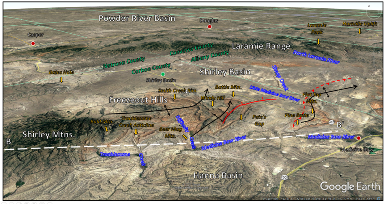
The Freezeout Hills (mountains) are located about ten miles north-northwest of the town of Medicine Bow at the southeast plunge of the Sweetwater Arch in central Wyoming. Phanerozoic sedimentary rocks are folded into two northeast trending anticlines (arch shape fold with the oldest rocks in the core). Unlike the other mountains along this trend, Precambrian basement rocks remain buried here.
The Late Jurassic Morrison Formation (156.2 to 146.8 million years ago) holds the most dinosaur bones discovered in North America. Thirty seven genera of dinosaur have been found in the formation.
The Late Jurassic Morrison Formation (156.2 to 146.8 million years ago) holds the most dinosaur bones discovered in North America. Thirty seven genera of dinosaur have been found in the formation.
Northeast aerial view of Freezeout Hills area. Folds called anticlines marked with black lines, dip and plunge direction of these folds indicated by arrows, and faults marked in red.
Image: Google Earth
Image: Google Earth
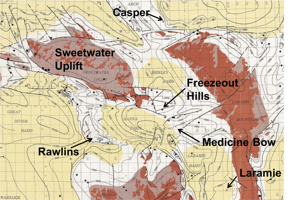
Wyoming Precambrian basement structure map. Contour interval of 5,000 feet. Basins are shaded light yellow, major uplifts with outcrops of Precambrian rocks are in dark brown, and intermediate depth areas are white. The black dots are wells drilled to the Precambrian. Freezeout Hills are located in T24 to 25 N and R79 to 80W on southeast plunge of the Sweetwater Uplift with Shirley Basin to north and Hanna Basin to south.
Image: After Blackstone, D.L., Jr., 1993, Precambrian basement map of Wyoming—Outcrop and structural configuration: Geological Survey of Wyoming [Wyoming State Geological Survey] Map Series 43, scale 1:1,000,000; https://www.wsgs.wyo.gov/products/wsgs-1993-ms-43.pdf.
Image: After Blackstone, D.L., Jr., 1993, Precambrian basement map of Wyoming—Outcrop and structural configuration: Geological Survey of Wyoming [Wyoming State Geological Survey] Map Series 43, scale 1:1,000,000; https://www.wsgs.wyo.gov/products/wsgs-1993-ms-43.pdf.
History of Freezeout Hills
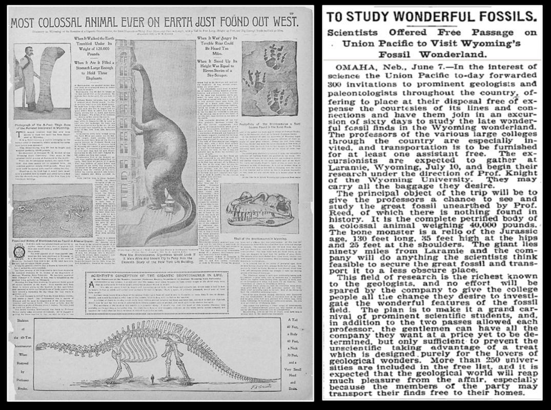
Wyoming is famous as a dinosaur graveyard. The discovery of a dinosaur boneyard at Como Buff in 1877 ignited the territory’s great dinosaur rush. The fossil-collecting rivalry between Marsh and Cope came to be known as the “bone war.” In 1898, William Reed discovered a thigh bone at the foot of the Freezeout Hills. A highly inaccurate New York newspaper article of the find caught Andrew Carnegie’s coveted attention and thus Wyoming’s turn-of-the-20th-century “museum bone rush” began. Chief rivals were the American Museum of Natural History (founded in 1869 in New York City), the Carnegie Museum (founded in 1896 in Pittsburgh), and the Field Colombian Museum (founded in 1893 in Chicago).
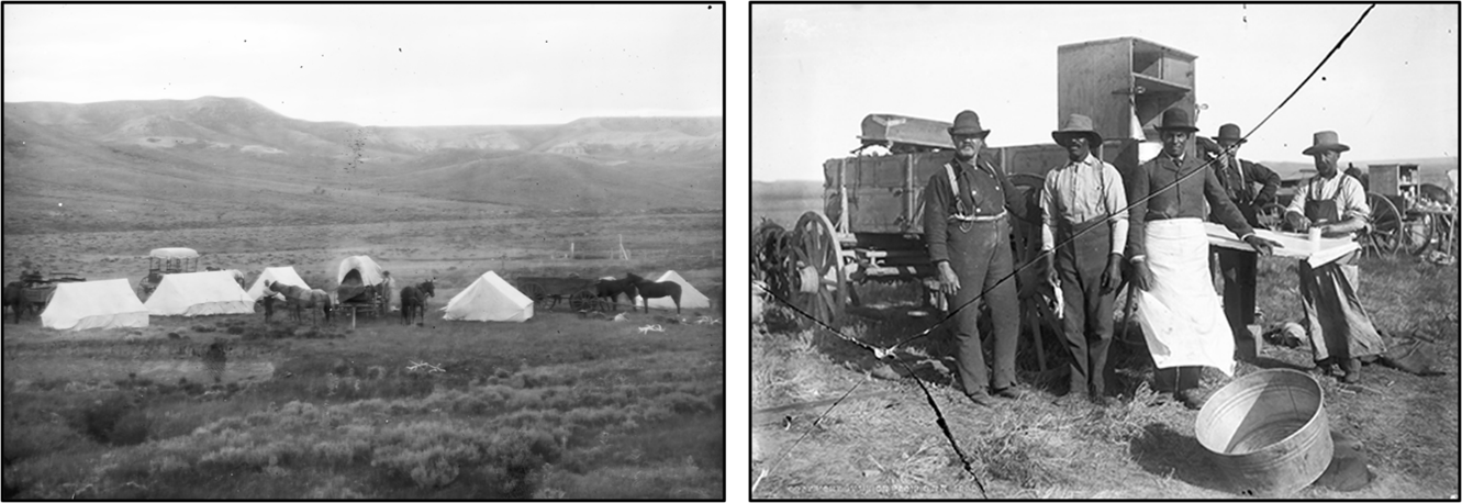
In 1898, the Union Pacific Railroad issued invitations to geologists and paleontologists from universities, colleges, and museums around the country to study fossils in Wyoming. The field trip was under the leadership of University of Wyoming Geology Professor Wilber Knight. Approximately 100 scientists took part in the 40 day expedition. Some of the longer camps were in the Freezeout Hills area.
In 1898, the Union Pacific Railroad issued invitations to geologists and paleontologists from universities, colleges, and museums around the country to study fossils in Wyoming. The field trip was under the leadership of University of Wyoming Geology Professor Wilber Knight. Approximately 100 scientists took part in the 40 day expedition. Some of the longer camps were in the Freezeout Hills area.
Left: Error-riddled article on 1898 sauropod discovery at Freezeout Hills. Right: 1899 UPRR fossil expedition invitation notice.
Image: Left: https://www.loc.gov/resource/sn83030180/1898-12-11/ed-1/?sp=33; Right: New York Times, Thursday June 8, 1899.
Image: Left: https://www.loc.gov/resource/sn83030180/1898-12-11/ed-1/?sp=33; Right: New York Times, Thursday June 8, 1899.
UPRR 1899 Fossil Expedition camp site (left) and cooks at chuckwagon (right), Freezeout Hills.
Image: Left & right: http://wyomingsteakhouse.com/uprr-1899-fossil-excursion/.
Image: Left & right: http://wyomingsteakhouse.com/uprr-1899-fossil-excursion/.
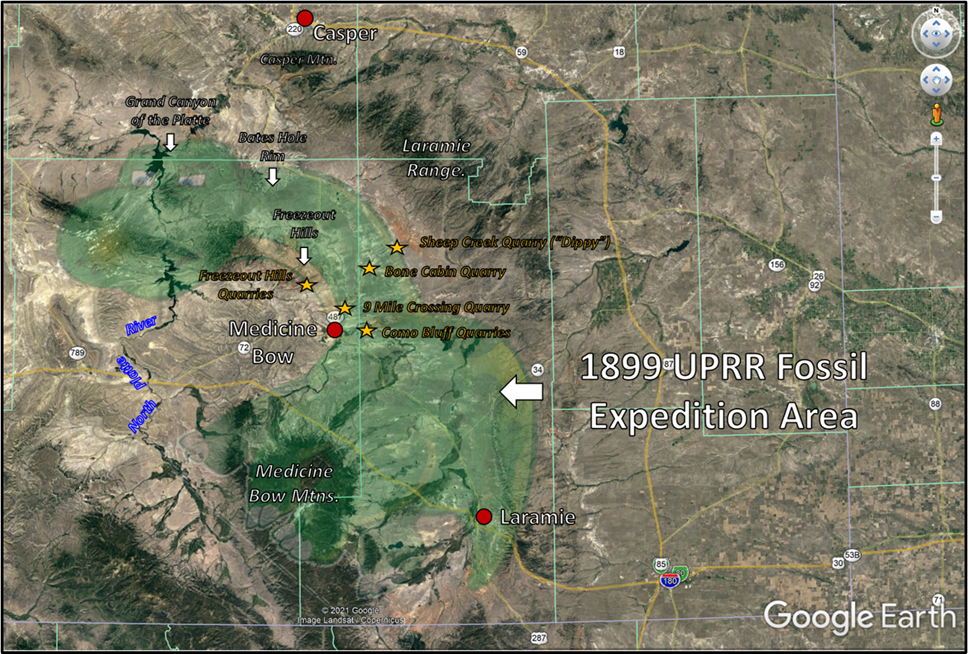
Approximate area of Union Pacific Railroad’s 1899 Fossil Expedition in green. Important quarry locations (gold Stars) and geographic sites (white arrows) are displayed.
Image: Google Earth
Image: Google Earth
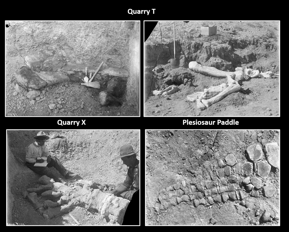
Fossils, in place, found at Freezeout Hills Quarries.
Image: Samuel H. Knight Papers, American Heritage Center Photos (counterclockwise from upper left) AH400044_00012, AH 400044_00018, AH 400044_00019, AH400044_02042; https://digitalcollections.uwyo.edu/luna/servlet/view/search?search=SUBMIT&q=freezeout+hills&dateRangeStart=&dateRangeEnd=&QuickSearchA=QuickSearchA.
Image: Samuel H. Knight Papers, American Heritage Center Photos (counterclockwise from upper left) AH400044_00012, AH 400044_00018, AH 400044_00019, AH400044_02042; https://digitalcollections.uwyo.edu/luna/servlet/view/search?search=SUBMIT&q=freezeout+hills&dateRangeStart=&dateRangeEnd=&QuickSearchA=QuickSearchA.
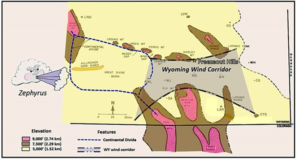
The origin of the Freezeout name is attributed to two stories. The first involves a letter carrier who was caught in a winter storm and inscribed on a rock “froze out.” The second arises from an English hunting party that were “froze out” in the 1870s. Both acknowledge the bitter winter weather in the area. The area lies along the Wyoming wind corridor where winter wind chills can reach minus 45 degrees Fahrenheit and frostbite could occur in about 10 minutes.
Freezeout Hills at northern margin of the Wyoming wind corridor.
Image: After Marwitz J.D., Dawson P.J. (1986) Low Level Airflow in Southern Wyoming during Wintertime by Aircraft. In: Xu Y. (eds) Proceedings of International Symposium on the Qinghai-Xizang Plateau and Mountain Meteorology. American Meteorological Society, Boston, MA, Fig. 1, p.478.
Image: After Marwitz J.D., Dawson P.J. (1986) Low Level Airflow in Southern Wyoming during Wintertime by Aircraft. In: Xu Y. (eds) Proceedings of International Symposium on the Qinghai-Xizang Plateau and Mountain Meteorology. American Meteorological Society, Boston, MA, Fig. 1, p.478.
Geology of Freezeout Hills
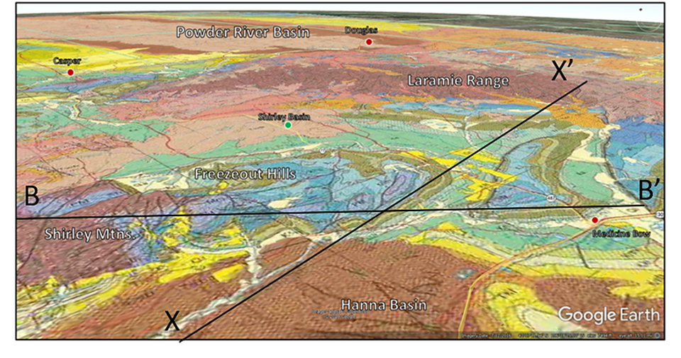
Geologic map of Freezeout Hills area. View to the northeast. The light to moderate brown areas are Tertiary rocks (Hanna & Shirley Basins), the green/olive areas are Cretaceous & Jurassic rocks, the blues/purples areas are Triassic, Permian and Mississippian rocks and the dark brown near the words Shirley Mtns and Laramie Range are Precambrian rocks.
Image: After Love, J.D., and Christiansen, A.C., 1985, Geologic map of Wyoming: U.S. Geological Survey, scale 1:500,000; https://ngmdb.usgs.gov/Prodesc/proddesc_16366.htm.
Image: After Love, J.D., and Christiansen, A.C., 1985, Geologic map of Wyoming: U.S. Geological Survey, scale 1:500,000; https://ngmdb.usgs.gov/Prodesc/proddesc_16366.htm.
Structural cross section B to B’ of Freezeout Hills area. Shirley Mountains on left (northwest) and Flat Top Anticline near the town of Medicine Bow on right edge (southeast). Location of cross section on geology map above.
Image: Image: After Lillegraven, J.A. and Snoke, A.W., 1996, A new look at the Laramide orogeny in the Seminoe and Shirley mountains, Freezeout Hills, and Hanna Basin, south-central Wyoming: Wyoming State Geological Survey, Public Information Circular No. 36, Fig. 26, p. 34; https://www.wsgs.wyo.gov/products/wsgs-1996-pic-36.pdf
Image: Image: After Lillegraven, J.A. and Snoke, A.W., 1996, A new look at the Laramide orogeny in the Seminoe and Shirley mountains, Freezeout Hills, and Hanna Basin, south-central Wyoming: Wyoming State Geological Survey, Public Information Circular No. 36, Fig. 26, p. 34; https://www.wsgs.wyo.gov/products/wsgs-1996-pic-36.pdf
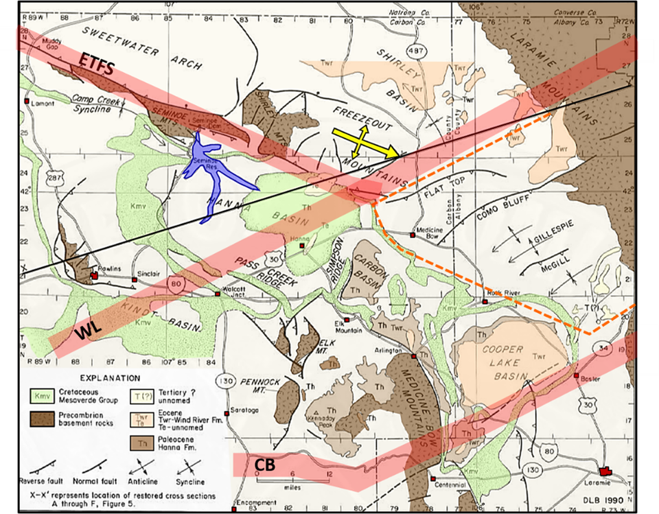
The major structural features in the region are the Emigrant Trail Thrust, Wyoming Lineament, and Cheyenne Belt. The Emigrant Trail thrust system is a northeast dipping series of faults that bounds the Sweetwater Arch (Granite Mountains) along the southwest side. This system extends southeastward and includes the Seminoe and Shirley Mountain Thrusts. The Sweetwater Arch was uplifted and transported to the southwest during Laramide tectonism 70 million years ago along these faults.
The Wyoming Lineament is a zone of deformation oriented N50 to 60 degrees E across the area located just southeast of the Freezeout Hills.
The Cheyenne Belt is an ancient Precambrian suture trending N50 to 55 degrees E between the Archean Wyoming Province and the Proterozoic Colorado island arcs. Southward subduction beneath the volcanic arcs of Colorado caused the collision with the Wyoming craton (1.75 billion years ago). Deformation, regional metamorphism, and the suture developed because of the continent-arc collision.
Generalized structure map of the Freezeout Hills region showing outcrops of selected Tertiary formations, the Mesaverde Group, and the Precambrian basement. Approximate locations of primary tectonic feature shown by red highlight and abbreviations: CB = Cheyenne Belt; ETFS = Emigrant Trail fault system; WL = Wyoming Lineament.
Image: After Blackstone, D.L., Jr., 1993, Overview of the Hannah, Carbon, and Cooper Lake Basins, Southeastern Wyoming: Wyoming State Geological Survey Report of Investigations No. 48, Fig. 2, p. 3; http://sales.wsgs.wyo.gov/overview-of-the-hanna-carbon-and-cooper-lake-basins-southeastern-wyoming-1991/.
Image: After Blackstone, D.L., Jr., 1993, Overview of the Hannah, Carbon, and Cooper Lake Basins, Southeastern Wyoming: Wyoming State Geological Survey Report of Investigations No. 48, Fig. 2, p. 3; http://sales.wsgs.wyo.gov/overview-of-the-hanna-carbon-and-cooper-lake-basins-southeastern-wyoming-1991/.
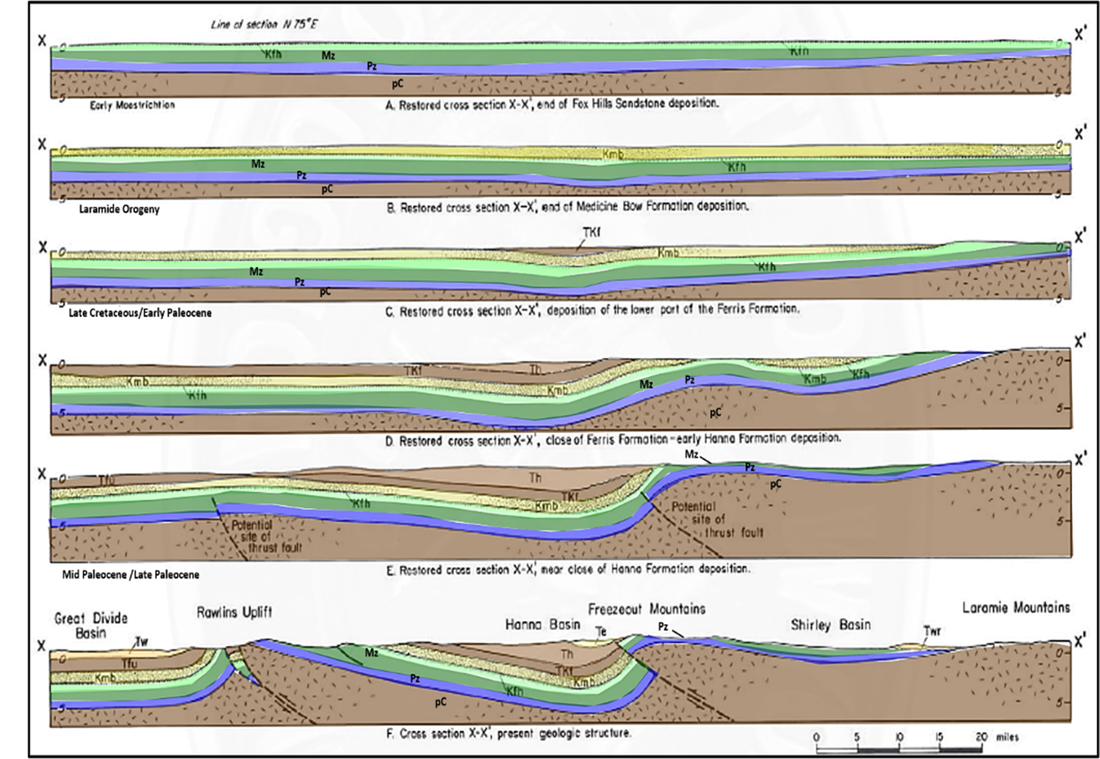
Structural evolution of the Freezeout Hills region from the Cretaceous pre-Laramide to the present day. Cross section X to X’ location shown on geology maps above. West-southwest on left and east-northeast on right. Abbreviations: Kfh = Cretaceous Fox Hills; Kmb = Cretaceous Medicine Bow; TKf = Tertiary/Cretaceous Ferris; Tf = Tertiary Hanna; Te = Tertiary Eocene unit; Tw = Tertiary Wasatch; Mz = Mesozoic; Pz = Paleozoic; pC = Precambrian.
Image: After Blackstone, D.L., Jr., 1993, Overview of the Hannah, Carbon, and Cooper Lake Basins, Southeastern Wyoming: Wyoming State Geological Survey Report of Investigations No. 48, Fig. 5, p. 11; http://sales.wsgs.wyo.gov/overview-of-the-hanna-carbon-and-cooper-lake-basins-southeastern-wyoming-1991/.
Image: After Blackstone, D.L., Jr., 1993, Overview of the Hannah, Carbon, and Cooper Lake Basins, Southeastern Wyoming: Wyoming State Geological Survey Report of Investigations No. 48, Fig. 5, p. 11; http://sales.wsgs.wyo.gov/overview-of-the-hanna-carbon-and-cooper-lake-basins-southeastern-wyoming-1991/.
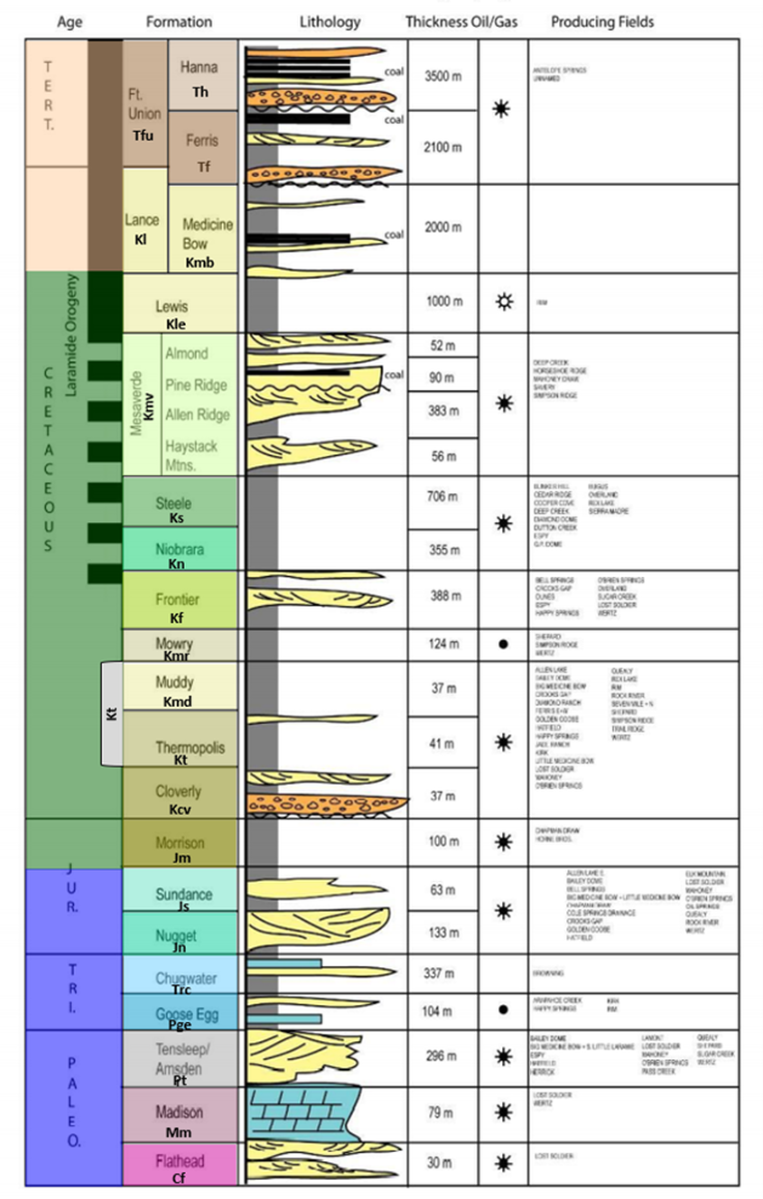
Freezeout Hills area stratigraphic column.
Image: After Wroblewski, A., 2008, Hanna Basin Fieldtrip Road Log: Wyoming Geological Association 2008 Field Conference; https://www.researchgate.net/publication/303483007_Hanna_Basin_Fieldtrip_Road_Log.
Image: After Wroblewski, A., 2008, Hanna Basin Fieldtrip Road Log: Wyoming Geological Association 2008 Field Conference; https://www.researchgate.net/publication/303483007_Hanna_Basin_Fieldtrip_Road_Log.
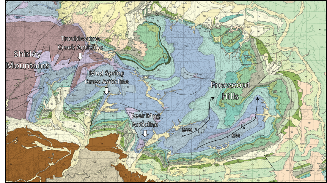
Erosion level at the Freezeout Hills does not reach the Precambrian basement. The Mississippian Madison Limestone (Mm, light purple) is the oldest unit exposed on the Freezeout Hills. The Upper Cretaceous Frontier Formation (Kf, light sage green) rings the plunging nose of the structure.
Closeup geologic map showing exposed sedimentary units of the Freezeout Hills area. Abbreviations: EFA = East Freezeout anticline; WFA = West Freezeout anticline; formation codes on area stratigraphic column above.
Image: Jones, N.R., and Gregory, R.W., 2011, Preliminary Geologic Map of the Shirley Basin 30' x 60' Quadrangle, Carbon, Natrona, Albany, and Converse Counties, Wyoming: Wyoming State Geological Survey, Open File Report 11-8, scale 1:100,000; https://ngmdb.usgs.gov/ngm-bin/pdp/zui_viewer.pl?id=56623.
Image: Jones, N.R., and Gregory, R.W., 2011, Preliminary Geologic Map of the Shirley Basin 30' x 60' Quadrangle, Carbon, Natrona, Albany, and Converse Counties, Wyoming: Wyoming State Geological Survey, Open File Report 11-8, scale 1:100,000; https://ngmdb.usgs.gov/ngm-bin/pdp/zui_viewer.pl?id=56623.
Bear Mug Anticline
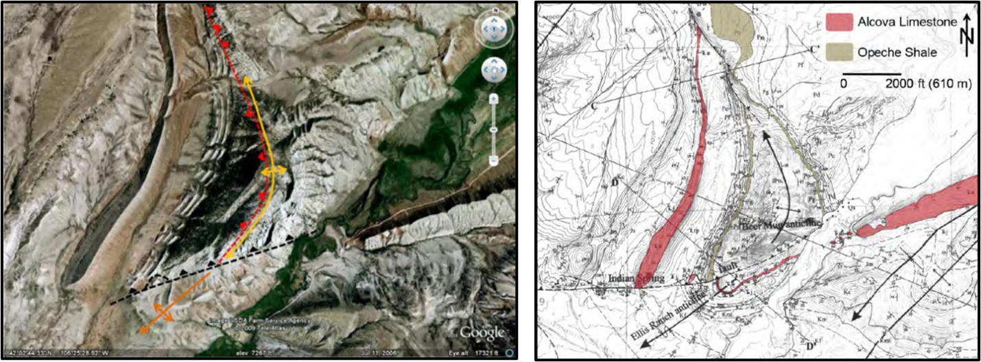
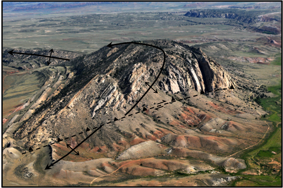
Beer Mug anticline at the southwest margin of the uplift is a classic geology textbook structure. The asymmetric structure has Tensleep Sandstone exposed in the core of the fold. The fold is cut on the southern end by a right lateral oblique fault (Indian Spring fault). The fold on the southern side is called the Ellis Ranch anticline.
Aerial view of Beer Mug Anticline (left) and generalized geology on topographic map (right). At the southern margin of the structure is the oblique slip Indian Spring fault (splay of the Shirley thrust fault). The Ellis Ranch anticline is on the footwall or downthrown side of the fault.
Image: Cooper, S.P. and Lorenz, J.C., 2007-2010, Tensleep Formation Fracture Study Compendium: Enhanced Oil Recovery Institute, Fig. on p. 230; https://www.eoriwyoming.org/library/tensleep-formation-fracture-study-compendium-2007.
Image: Cooper, S.P. and Lorenz, J.C., 2007-2010, Tensleep Formation Fracture Study Compendium: Enhanced Oil Recovery Institute, Fig. on p. 230; https://www.eoriwyoming.org/library/tensleep-formation-fracture-study-compendium-2007.
Northeast aerial view of Beer Mug anticline, southern Freezeout Hills.
Image: After Lillegraven, J.A., 2015, Rocky Mountain Geology, June 2015, v. 50, no. 1, Frontispiece; https://pubs.geoscienceworld.org/uwyo/rmg/article/50/1/30/141117/Late-Laramide-tectonic-fragmentation-of-the
Image: After Lillegraven, J.A., 2015, Rocky Mountain Geology, June 2015, v. 50, no. 1, Frontispiece; https://pubs.geoscienceworld.org/uwyo/rmg/article/50/1/30/141117/Late-Laramide-tectonic-fragmentation-of-the
Beer Mug anticline, Freezeout Hills, Wyoming. A: Photograph looking north at fault-line scarp (tear fault) in Tensleep Sandstone (Pt) outcrop. Note vertical dip in Goose Egg (Pge) beds of (eastern or right) forelimb and oversteepened, 30°+ backlimb dip (western or left), which is due to counterclockwise rotation of Beer Mug thrust fold into an east-dipping basin-boundary thrust zone a short distance to the west. Approximate scale shown by 5 ft fence posts. B: Structural contour map on Tensleep Sandstone (Pt), map shows location of photo station and structural cross section in C. Contours in ft x 100. C. Structural cross section showing location of photo A.
Image: After Stone, D. S., 1993, Basement-involved thrust-generated folds as seismically imaged in the subsurface of the central Rocky Mountain foreland, in Schmidt, C. J., Chase, R. B., and Erslev, E. A., eds., Laramide Basement Deformation in the Rocky Mountain Foreland of the Western United States: Boulder, Colorado, Geological Society of America Special Paper 280, Fig. 31, P. 307; https://pubs.geoscienceworld.org/gsa/books/book/422/chapter/3798413/Basement-involved-thrust-generated-folds-as
Image: After Stone, D. S., 1993, Basement-involved thrust-generated folds as seismically imaged in the subsurface of the central Rocky Mountain foreland, in Schmidt, C. J., Chase, R. B., and Erslev, E. A., eds., Laramide Basement Deformation in the Rocky Mountain Foreland of the Western United States: Boulder, Colorado, Geological Society of America Special Paper 280, Fig. 31, P. 307; https://pubs.geoscienceworld.org/gsa/books/book/422/chapter/3798413/Basement-involved-thrust-generated-folds-as
Mud Spring Draw Anticline and Troublesome Creek Anticline
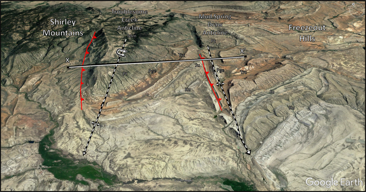
Mud Spring Draw anticline is 4.5 miles northwest of the Beer Mug structure. The anticline trends N26 degrees E and is fault bound on the tightly folded west flank. The Shirley Mountains lie two miles to the west. Bald Mountain is a portion of the large recumbent Troublesome Creek anticline at the southeast margin of the Shirley Mountains.
North-northwest aerial view of Troublesome Creek and Mud Spring Draw anticlines. Axis of anticlines marked with black and white dashed lines. Permian Goose Egg Formation (Pge) Is exposed in the core of the Mud Spring fold (Freezeout Hills) while Precambrian rock is exposed in Troublesome Creek overturned structure (Shirley Mountains). Abbreviations: K = Cretaceous Cloverly to Mowry-Thermopolis; J = Jurassic Sundance to Morrison; TR = Triassic Chugwater Group; Pge = Permian Goose Egg; Pt = Pennsylvanian Tensleep :Mm = Mississippian Madison
Image: After Google Earth
Image: After Google Earth
Troublesome Creek anticline (TCA), Shirley Mountains and Mud Spring Draw anticline (MSA) west to east structural cross section. Abbreviations: J = Jurassic units; Tr = Triassic units; Pzu = upper Paleozoic rocks; Pzl = lower Paleozoic rocks; Wx = Precambrian crystalline basement.
Image: After Weil, A. B., A. Yonkee, and M. Schultz, 2016, Tectonic evolution of a Laramide transverse structural zone: Sweetwater Arch, south central Wyoming, Tectonics, 35, Fig. 5, p. 1097; https://agupubs.onlinelibrary.wiley.com/doi/pdf/10.1002/2016TC004122.
Image: After Weil, A. B., A. Yonkee, and M. Schultz, 2016, Tectonic evolution of a Laramide transverse structural zone: Sweetwater Arch, south central Wyoming, Tectonics, 35, Fig. 5, p. 1097; https://agupubs.onlinelibrary.wiley.com/doi/pdf/10.1002/2016TC004122.

The material on this page is copyrighted


