Photo by Quincy Sondeno
Wow Factor (4 out of 5 stars):
Geologist Factor (2 out of 5 stars):
Attraction
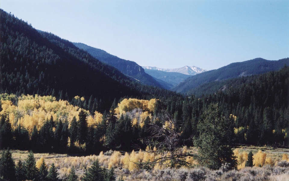
Mining ghost town, walks to historic buildings, glaciated Wood River valley surrounded by peaks above timberline, remote, high elevation, and optional longer hikes. A trip to Kirwin is a 4WD adventure in itself with several river and stream crossings.
Geology of Kirwin
In 1885 prospectors Harry Adams and William Kirwin, who were on their way to the Montana gold fields, spent a day deer hunting in the headwaters area of the Wood River. While tracking down prey they found gold ore on Spar Mountain. When Adams took an ore sample to the Arland (established 1884) post office to ship for assay, he stopped for refreshment at the Arland saloon. Whether it was too much refreshment or too much crowing about their luck, the news of a new gold discovery spread. Thus began the gold fever that gave rise to the mountain town of Kirwin.
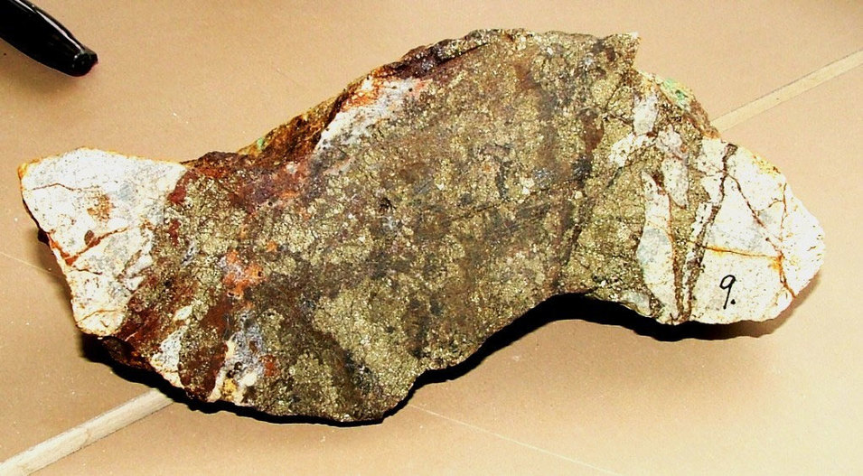
Gold- and silver-bearing vein sample from the Kirwin district, Wyoming. The surrounding country rock is bleached white due to the intense phyllic alteration (addition of quartz and potassium to the original host rock). In the Kirwin district where many vein samples were rich in silver and some assayed more than 100 ounces per ton in silver.
Image from: Hausel, W.D., 2010, Gem Hunter – The Prospector’s Newsletter: Vol. 2, No. 10. http://www.cheyennegpaa.com/newsletters/2010/octgemhunter.pdf
Image from: Hausel, W.D., 2010, Gem Hunter – The Prospector’s Newsletter: Vol. 2, No. 10. http://www.cheyennegpaa.com/newsletters/2010/octgemhunter.pdf
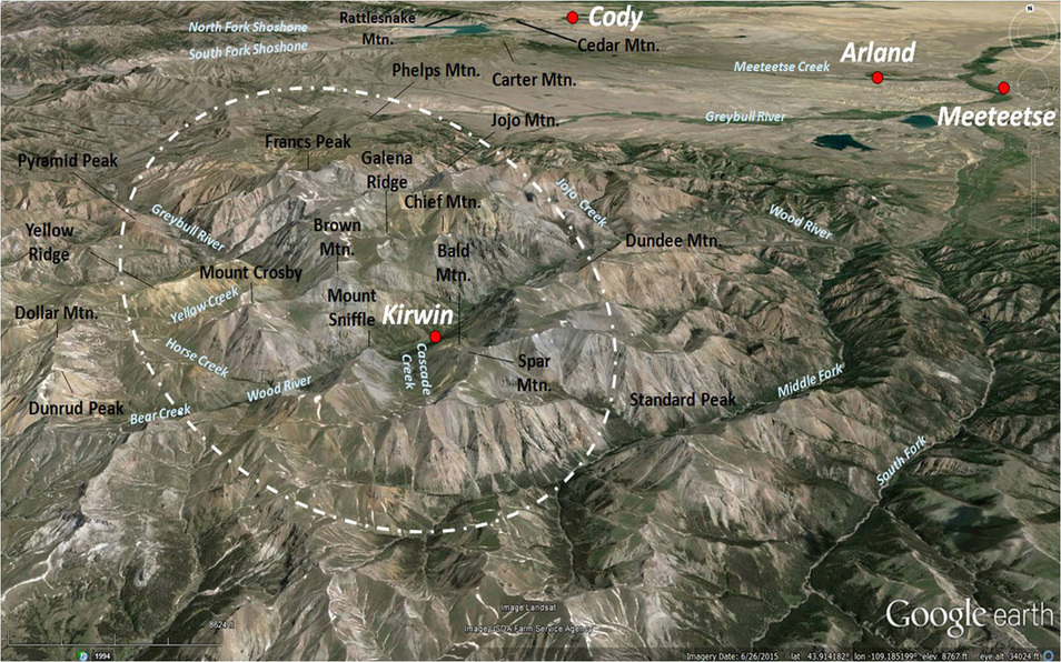
The ghost town is about 38 miles southwest of Meeteetse (established 1890). It sits at an elevation of 9,200 feet surrounded by peaks of the southern Absaroka Range that rise to more than 12,000 feet (see figure below). This site is in the Kirwin volcanic complex (49.0-43.7 Ma), one of the twelve major eruptive centers within the Absaroka Range.
North Aerial (34,000 foot) View of Kirwin area. Approximate location of vent complex shown by white dashed line.
Image from: Google Earth Image
Image from: Google Earth Image
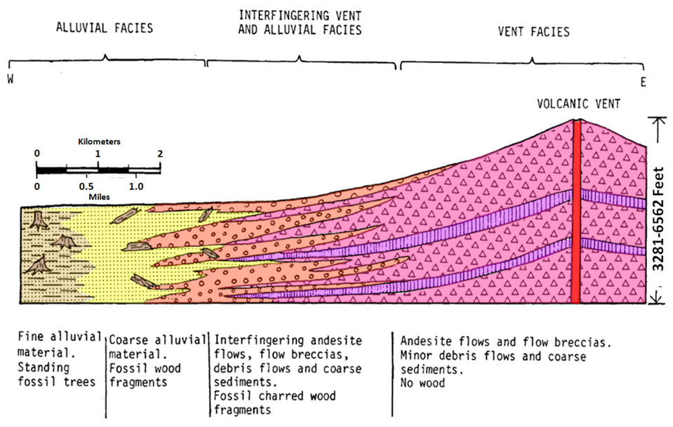
There are two types: vent facies and alluvial facies. Vent facies rocks consist of andesite flows and flow breccias, with minor debris flows and coarse sediments. Intrusive bodies and radial dikes are common in the vent facies. Alluvial facies are coarse to fine eroded volcanic material, often containing fossil wood fragments. Kirwin is an area where the volcanic intrusive and extrusive vent rocks interfinger with the volcaniclastic rocks that form an alluvial apron around the volcanic edifice. The volcanic rock complex forms a high, broad plateau-like surface. This plateau displays a continuous erosion level between 11,000 and 12,400 feet (the Rocky Mountain high level erosion surface).
Hypothetical cross section model of a typical Absaroka volcanic center.
Image from: After LaPointe, D.D., 1977, MS Thesis, Univ. MT, Fig. 12, p. 46.
Image from: After LaPointe, D.D., 1977, MS Thesis, Univ. MT, Fig. 12, p. 46.
Ore minerals targeted by the early miners occur as fracture-fill in narrow, steeply dipping veins that cut the volcanic flows and sediments. These veins are associated with the intrusive bodies and often are parallel to dikes that probably fractured the rock. Hydrothermal fluids moved through the fractures and deposited the ore minerals and altered the volcanic rock. The veins are often banded, vuggy, crusty and sometimes stained yellow to brown from iron oxide and green from malachite. Principal ore minerals are pyrite, galena, sphalerite, chalcopyrite, chalcocite, tetrahedrite, molybdenite, stephanite and hematite. Galena, which is a lead sulfide is the main silver-bearing ore mineral. Other minerals in the veins are quartz, calcite, siderite and barite.
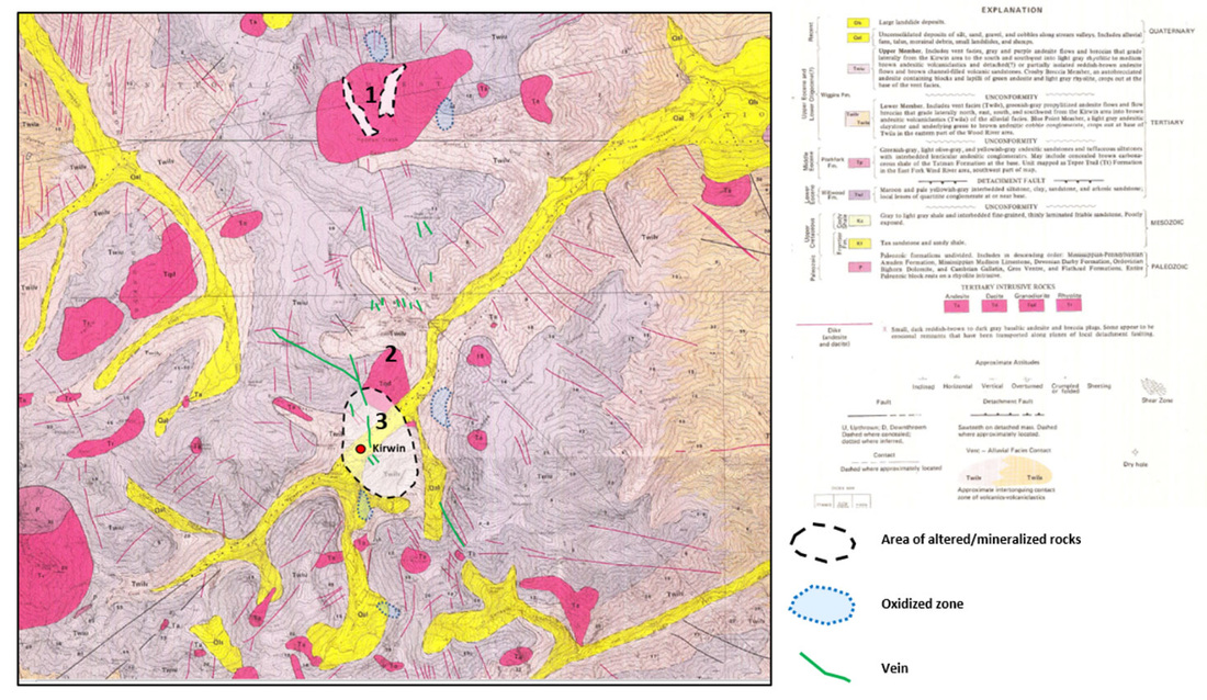
Kirwin Area geologic map showing the three mineralized intrusive complexes: 1. Medicine Creek Granodiorite, 2. Brown Mountain Granodiorite, and 3. Kirwin Mineralized Area. Oxidized zones and mineralized veins are also noted.
Image from: Base: Wilson, W.H., 1982, Geologic map of the Dick Creek Lakes, Dunrud Peak, Francs Peak, Noon Point, and Twin Peaks quadrangles, Fremont, Hot Springs, and Park Counties, Wyoming: Geological Survey of Wyoming [Wyoming State Geological Survey] Map Series 10, 1 sheet, scale 1:24,000. Overlay: After Hausel, W.D., 1982, General Geologic Setting and Mineralization of the Porphyry Copper Deposits, Absaroka Volcanic Plateau: WGA, Fig. 3, p. 302 (Modified from Wilson, 1964b, 1975; Nowell, 1971).
Image from: Base: Wilson, W.H., 1982, Geologic map of the Dick Creek Lakes, Dunrud Peak, Francs Peak, Noon Point, and Twin Peaks quadrangles, Fremont, Hot Springs, and Park Counties, Wyoming: Geological Survey of Wyoming [Wyoming State Geological Survey] Map Series 10, 1 sheet, scale 1:24,000. Overlay: After Hausel, W.D., 1982, General Geologic Setting and Mineralization of the Porphyry Copper Deposits, Absaroka Volcanic Plateau: WGA, Fig. 3, p. 302 (Modified from Wilson, 1964b, 1975; Nowell, 1971).
The Wood River Mining District was formed in 1891 to organize prospector claims and lure outside investors. By the turn of the century most claims were consolidated into two companies: the Galena Ridge (1902) and the Shoshone Mountain (1903). Investors were eager to develop the promising gold, silver, copper and lead properties. As far as mining communities go Kirwin was fairly tame. The companies would not allow saloons, gambling, brothels or single women to reside in town (except for the school teacher). There was a person named “Lucile the Palmist” for entertainment, but when it was discovered there was more to her services than palm reading she was run out of town. There are reports of saloons at Jojo Creek (where Double D Ranch is located) and at the mouth of the Wood River for the thirsty souls.
|
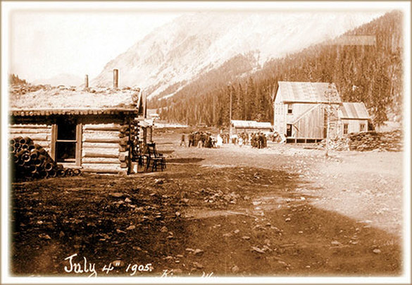
Mainstreet of Kirwin, Wyoming, 1905. At its peak the town housed about 200 people, mostly miners and their families. U.S. Forest Service Image.
From: http://www.fs.usda.gov/Internet/FSE_MEDIA/stelprdb5183441.jp |
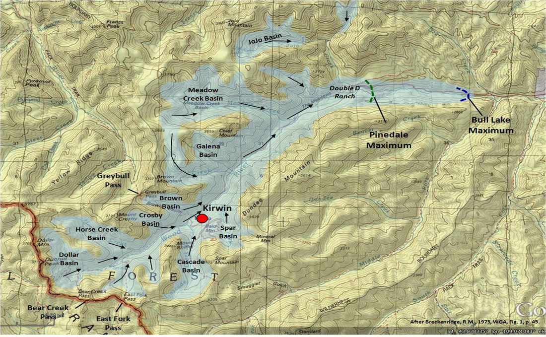
Winters were hard in Kirwin. The landscape still carries the fingerprints of the last Pleistocene glaciation. The glacial features include u-shaped valleys, cirques, arêtes and cols. A well near Double D Ranch encountered about 150 feet of glacial fluvial sediment.
Maximum glaciation in the Kirwin area. Direction of ice movement shown by black arrows. Bull Lake: 151-1160 thousand years ago; Pinedale: 21-15 thousand years ago. Image from: Base: Google Earth Image with Earth Point Topo from USGS, Overlay Data: Breckenridge, R.M., 1979, Quaternary Geology of the Wood River Area, Wyoming: WGA 27th Annual Field Conference Guidebook, Fig. 1, p. 45.
By 1906 eighteen mines had dug 12 to 15 thousand linear feet of exploratory tunnels to sample ore veins at 500 to 1,500 foot depth. Only one known carload of ore was ever shipped from Kirwin (from the No. 2 Byron Tunnel). The ore had a net value of only $65 per ton.
The winter of 1907 was particularly brutal on Kirwin’s 200 residents. A blizzard lasting eight days dropped over fifty feet of snow. On the night of February 5, 1907, a 300 foot wide avalanche roared down Brown Mountain destroying structures and killing three people. Almost all the townsfolk and miners left with the coming of spring.
The Double D Ranch made an attempt to exploit the “Dude Ranch” craze of the 1930s but was unsuccessful. The aviatrix Amelia Earhart and her publisher husband George Putnam were building a vacation home in the area when she disappeared on her last flight. Plans by AMAX in the 1960s and 1970s to open pit mine Bald Mountain for copper failed due to stiff environmental opposition and falling product prices. The Mellon Foundation purchased the company’s leases and donated it to the people of the United States. In the 1990s the US Forest Service and others began restoration and scientific investigations to improve and preserve this spectacular place.
Nashua Telegraph headline from Wednesday, July 9, 1975. Image from: Archives of the Nashua Telegraph online, Hudson, NH.
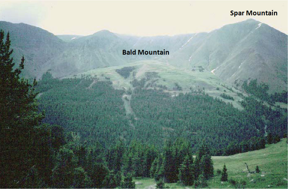
Proposed site of Bald Mountain open pit mine, Kirwin, Wyoming.
Image from: http://gemhunter.webs.com/documents/Precious%20Metals%20Part%202.pdf
Image from: http://gemhunter.webs.com/documents/Precious%20Metals%20Part%202.pdf
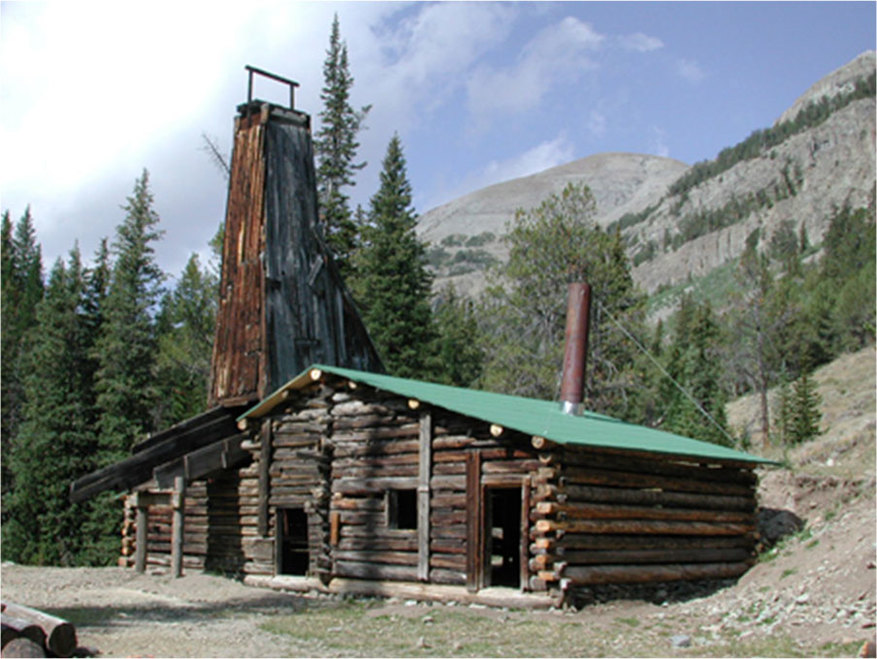
Tumlin mine shaft, Kirwin, Wyoming.
Image from: http://www.fs.usda.gov/Internet/FSE_MEDIA/stelprdb5183181.jpg
Image from: http://www.fs.usda.gov/Internet/FSE_MEDIA/stelprdb5183181.jpg
Mark Twain has been attributed with saying “A mine is a hole in the ground with a liar for an owner.” In his 1914 USGS report on the ore deposits, Hewett wrote ”Kirwin has been the scene of much ill-advised mining practice.” Whether the mining activity at Kirwin was “shady” or “shoddy,” the end result was the same. Kirwin became a Wyoming ghost town.
See a great 57 minute video entitled Risky Business: The Ghost Town of Kirwin,
from the Main Street, Wyoming, Wyoming PBS, 2017
from the Main Street, Wyoming, Wyoming PBS, 2017
What you will see at Kirwin
It is a 65 mile drive from Cody to Kirwin that takes about 2 hours each way. The first 43 miles is paved highway, the next 10 miles is graded gravel county road, and the last 12 miles is rough, but not terrible Forest Service one-lane wide road that requires 4WD with good clearance. Let me repeat, this last section is not a passenger car road and is narrow in places. Since you will be fording the Wood River and a couple side streams with your vehicle, access occurs only after high-water has subsided. Dependent on snow-pack, temperature, rainfall, and fall weather, access can run from late July through early October. Inquire locally about conditions and make your own decision. The trip up the Wood River is scenic with irrigated pasture in the valley on large cattle ranches. With higher elevation, it transitions to pine trees, summer vacation homes, Forest Service campgrounds, trail heads and then finally a slow, but beautiful drive to Kirwin in a steep-sided valley. Unfortunately, the forest in this area has a lot of dead kill from a pine beetle infestation. Kirwin was a small uneconomic mining town. Most of the shafts and adits are now caved or flooded. The Forest Service with the help of volunteer summer crews has stabilized and put new roofs on the buildings that could be saved. There are several short walks to visit various buildings and mines. There are also multiple options for longer hikes. This is grizzly bear habitat so walk with a partner and bring your bear spray! During August, there is one large public group tour run to Kirwin from Meeteetse.
Directions to Kirwin
Starting at the intersection of US 14-16-20 (Sheridan Ave) and US 14A (16th St) in downtown Cody, head east toward Greybull on US 14-16-20, 2.2 miles turn right on WY 120 which is the road to Meeteetse and Thermopolis, 13.9 miles on left is the Oregon Basin oil field, on right is ridge of Cretaceous Mesaverde Sandstone ringing west flank of the Oregon Basin Field, 16.8 miles highway cuts through Mesaverde Sandstone ridges, 21.1 miles Paleocene Fort Union outcrop on right, view to left of Mesaverde ringing south plunge of Oregon Basin Field, 29.0 miles pull-off on right for historical sign about abandoned town of Arland, 31.1 miles town of Meeteetse, 31.4 miles turn right on WY 290 toward Pitchfork and Sunshine Reservoir, 37.4 miles bridge over Wood River, 37.9 miles turn left Wood River Road County Road 4DT, 42.3 miles North Sunshine Oil Field with cumulative 6.3 million barrels of heavy oil from the Tensleep and Phosphoria Formations at depth of about 4,000 feet, 42.8 miles bridge over Wood River, 43.2 miles end of pavement, 44.6 miles bridge over Wood River, 53.5 miles Forest Service boundary, 54.2 miles Wood River Forest Service Campground, 54.8 miles Middle Fork Wood River trail head, 56.6 miles Brown Mountain Forest Service Campground, 58.6 miles ford Jojo Creek, 58.7 miles turn-off on right for historic Double D Ranch, 58.9 miles ford Wood River, 60.5 miles road forks stay to right and ford Wood River, 61.1 miles Meadow Creek trailhead on right, 63.1 miles Galena Creek flowing from right has the Iowa Mine on the north side of creek about 1,000 vertical feet and one-quarter mile above the road (no trail), 63.2 miles Canyon Creek flowing from the right has six mines on the north or right side of creek over a one mile stretch that climbs 2,000 vertical feet above the road (no trail), mines include the Golden Ridge Tunnel, Little Johnnie Mine, Mendota Mine, Manilla Mine, Oregon Mine and Anaconda mine, 63.2 miles road forks stay to right, left fork has drilling pad and dry hole for Mobil F32X-1 exploration oil well drilled in 1970 (it drilled 2,118 feet volcanic rock then entered Cretaceous Thermopolis, total depth of 4,860 feet in Tensleep Sandstone, on uphill side of drilling pad in trees is old mining equipment), 65.1 miles Kirwin parking lot and toilet on right.
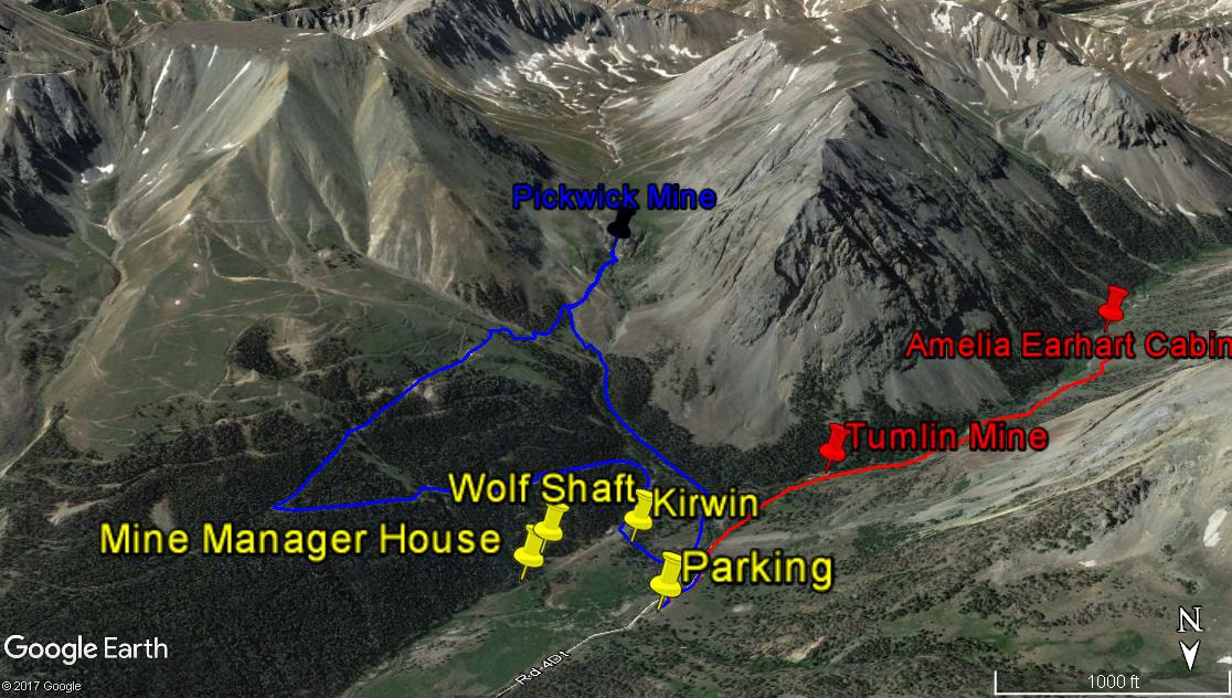
Walk to Tumlin Mine (see picture above and red on map below) and Amelia Earhart Cabin Foundation
The road is closed to vehicles just a short distance upstream of the Kirwin parking lot. Walk the dirt road adjacent and to the right of the Wood River in an upstream direction for about 0.4 miles. The Tumlin Mine is on the left and adjacent to the river. If you continue walking up this road for just under a mile, you will get to the remains of a log cabin only a couple of logs high on two sides that was being built in 1936 for Amelia Earhart. Construction was started just before she disappeared in the Pacific on her attempted around-the-world flight. The cabin was never finished and the logs are just beyond a couple of cabins on the left.
Walk to Kirwin, Wolf Shaft and Mine Manager House (see yellow on map below)
Walk up the road about 500 feet from parking lot until you about reach the road closure gate, just before the gate a trail on left leads to a foot bridge, cross the Wood River on foot bridge, follow the path and dirt road about 700 feet to Kirwin, turn left (northeast or downstream) and walk about 600 feet to Wolf Shaft on right, walk an additional 250 feet down the road (downstream) to see the mine manager house.
Hike part way up Bald Mountain, Continue to Pickwick Mine on Cascade Creek, Return to Parking Lot Via Trail Along Cascade Creek (see blue on map below)
On the road through the center of the Kirwin buildings, walk to the southwest (opposite direction of Wolf Shaft), after about 800 feet road switchbacks to left and climbs to northeast, after straight stretch of 0.5 mile road switchbacks to right and climbs to south-southwest, after straight climbing stretch of about 0.5 mile you will reach remains of a couple cabins, go no further up Bald Mountain, but continue straight past cabins about 0.5 miles to south-southwest through gully using road/trail until you reach tailings pile at Cascade Creek. The Forest Service has closed the entrance to Pickwick mine, but you should be able to find some ore mineral specimens in the tailings pile. Return on same road for about 0.25 miles and drop down to Cascade Creek, pick up trail that follows Cascade Creek on west side of creek 0.5 miles down to the Wood River, turn right at Wood River until reaching foot bridge to cross to parking lot.
Other More Significant Hikes
One could continue the Tumlin Mine hike up the Wood River to Bear Creek Pass or East Fork Pass or Horse Creek trail; one could continue the Pickwick Mine hike much further up the Cascade Creek trail; one could head northwest from the Kirwin parking lot on a trail up to Brown Basin and over Greybull Pass into the Greybull River drainage; on road to Kirwin one could hike up Meadow Creek trail to Meadow Creek Basin. Summitpost has good descriptions and photos of a lot of hikes to the surrounding peaks in the Kirwin area (http://www.summitpost.org/kirwin/243540).
South view of Kirwin area. Kirwin attractions in yellow, hike to Tumlin Mine and Amelia Earhart cabin site in red, and a hike to the Pickwick mine and tailings pile along Cascade Creek in blue.
Google Earth image
Google Earth image

The material on this page is copyrighted
