Wow Factor (3 out of 5 stars):
Geologist Factor (5 out of 5 stars):
Geology of Bighorn River Area Caves
Caves have always fascinated people. To some they were the portal to Hades. For Plato, a cave was an allegory for how people perceive reality. To Odysseus, Ali Baba and Tom Sawyer they were the sites of fabulous adventures. In Wyoming and Montana cave legends speak of great treasure and even a race of "Little People." The underworld of caves is a treasure vault of natural beauty and is a window on the processes working in the subsurface. The cave environment is characterized by several features: darkness (no photosynthesis), relatively constant temperatures (mitigates climate changes in the air and water) and limited organic matter (limits amount and diversity of energy sources).
About 98 percent of Wyoming’s karst, caves and rock shelters occur in the 2,000+ foot thick Paleozoic section. Marine carbonate rocks dominate the lithology of this section. They were deposited over 275 million years (520-245 Ma) on a broad platform that developed across the Archean Wyoming craton. The Mississippian Madison Formation (359-347 Ma) hosts the majority of caves in Wyoming and Montana.
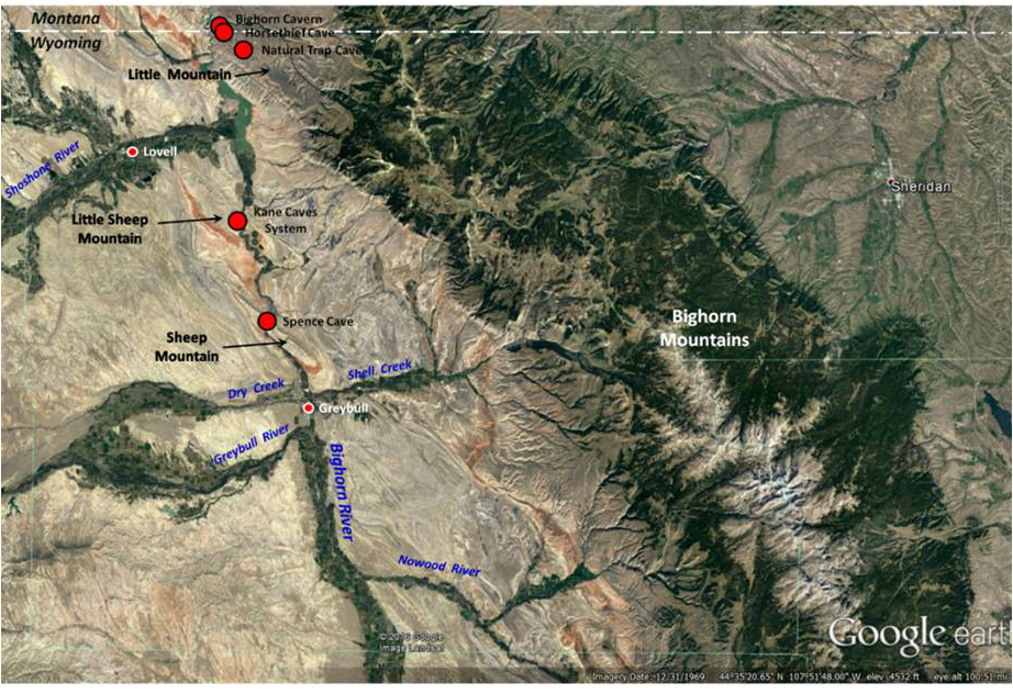
There are seven noteworthy Wyoming caves developed in the Madison Formation along the Bighorn River in the northeastern corner of Bighorn County. These caves are developed on three anticlinal structures: Little Mountain, Little Sheep Mountain, and Sheep Mountain. They are not commercial show caves for tourists, but natural caverns for experienced spelunkers and research teams that have obtained the necessary permit, include a cave expert member and are outfitted with the proper safety gear.
Caves in the Bighorn River area
Google Earth Image
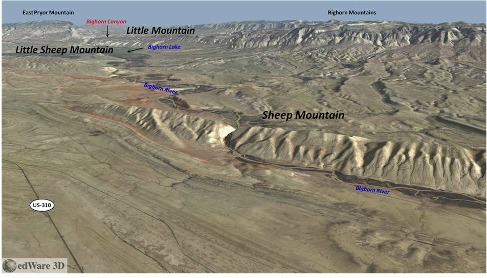
Google Earth Image
North aerial view of Bighorn River cave area locations at Little Mountain, Little Sheep Mountain, and Sheep Mountain.
After Computer Terrane Mapping, Inc. http://www.ctmap.com/ctm_image/sheepmtn.png
After Computer Terrane Mapping, Inc. http://www.ctmap.com/ctm_image/sheepmtn.png
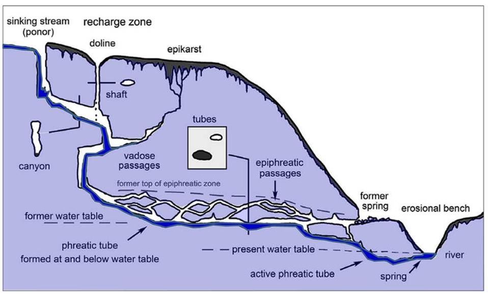
The caves along the Bighorn River are all solution caves formed by the dissolution of carbonate rocks. They include active and inactive cave systems, with several that are located about a thousand feet above the current water table. The classical theory of solution cave development (speleogenesis) was proposed in the early twentieth century and invoked dissolution by carbonic acid from above (vadose), below (phreatic) or at the water table. Water and CO2 seep into the carbonate rock from above (epigenic), generating carbonic acid. The chemical formula of this process is:
CO2 (g) + H2O (aq) ⇌ H2CO3 (aq)
Carbon Dioxide (atmosphere & soil) and Water (meteoric) yields Carbonic acid
CaCO3 (s) + H2CO3 (aq) ⇌ Ca2+ (aq) + 2HCO3- (aq)
Limestone and Carbonic acid yields Calcium ion and Bicarbonate solution
Carbon Dioxide (atmosphere & soil) and Water (meteoric) yields Carbonic acid
CaCO3 (s) + H2CO3 (aq) ⇌ Ca2+ (aq) + 2HCO3- (aq)
Limestone and Carbonic acid yields Calcium ion and Bicarbonate solution
Generalized model of epigenic (enters from above) carbonate dissolution by carbonic acid.
Audra, P. and Palmer, A.N. 2015, ACTA CARSOLOGICA 44/3, 315–348, Fig 1, p. 318.
http://ojs.zrc-sazu.si/carsologica/article/viewFile/1960/3959
Audra, P. and Palmer, A.N. 2015, ACTA CARSOLOGICA 44/3, 315–348, Fig 1, p. 318.
http://ojs.zrc-sazu.si/carsologica/article/viewFile/1960/3959
A second method of cave formation, sulfuric acid speleogenesis, was first described in 1973. It proposed carbonate dissolution by sulfuric acid from hydrothermal springs rising from the subsurface. Sulfuric acid is formed when sulfur dioxide reacts with oxygen and water. The chemical formula of this process is:
H2S (g*) + 2O2 (g) ⇌ H2SO4 (aq) (oxidation)
Hydrogen Sulfide gas (soluble in water) and Oxygen yields Sulfuric Acid
CaCO3 (s) + H2SO4 (aq) ---------> CaSO4 (s) + H2O (aq) + CO2 (g)
Limestone and Sulfuric Acid yields Gypsum/Anhydrite and Water and Carbon Dioxide
Hydrogen Sulfide gas (soluble in water) and Oxygen yields Sulfuric Acid
CaCO3 (s) + H2SO4 (aq) ---------> CaSO4 (s) + H2O (aq) + CO2 (g)
Limestone and Sulfuric Acid yields Gypsum/Anhydrite and Water and Carbon Dioxide
The massive passages and rooms of Carlsbad Cavern and Lechguilla Cave in the Guadalupe Mountains of New Mexico were created by this process. Recent research has focused on the microbiology of sulfuric acid caves.
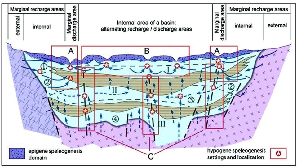
Generalized basin model showing the domains of carbonate dissolution epigenic (from above) and hypogenic (from below). Regional hydrodynamics of a basin showing decrease in communication and a progressive shift from lateral to ascending flow with depth. Boxes distinguish marginal areas (A), internal areas (B) and deep zones (C). Hypogenic speleogenesis occurs in zones of convergence, where mixing occurs (Klimchouk 2013c, after Vsevolozhskiy 2007).
After Audra, P. and Palmer, A.N. 2015, ACTA CARSOLOGICA 44/3, 315–348, Fig 19, p. 332.
http://ojs.zrc-sazu.si/carsologica/article/viewFile/1960/3959
After Audra, P. and Palmer, A.N. 2015, ACTA CARSOLOGICA 44/3, 315–348, Fig 19, p. 332.
http://ojs.zrc-sazu.si/carsologica/article/viewFile/1960/3959
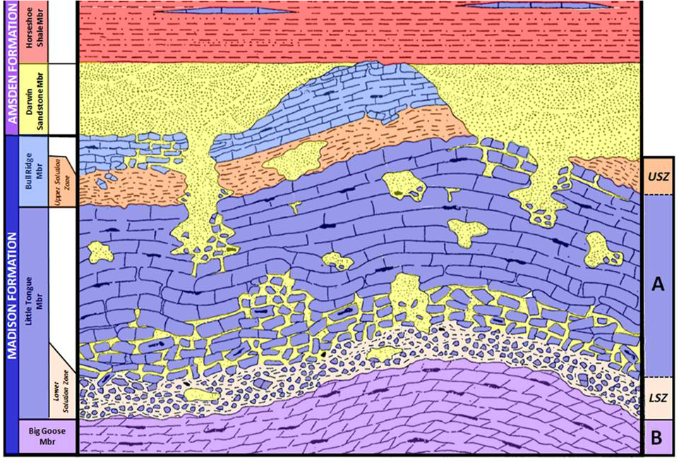
Major controls on cave formation include structure and rock lithology, fluid flow above and through the rocks, and chemical and biological factors. Rock lithology is a function of the depositional environments present in the tectonic setting as the units were deposited. The Paleozoic section contains the largest volume of laterally continuous carbonate rock. The Madison Formation (359-347 Ma) ranges from 700 to 1,000 feet thick and was subaerially exposed for about 10 million years after deposition. A karst landscape developed in the upper 200 feet of the formation. Dissolution of evaporite beds during this long exposure created regional solution zones at the base of the Bull Ridge and the Little Tongue members of the Madison A subzone.
Generalized cross section of the Upper Madison Formation. The upper solution zone (USZ) developed at the base of the Bull Ridge Member. The lower solution zone (LSZ) developed at the base of the Little Tongue Member. Blue: limestone; Light purple: dolomite; Red: silty shale; Yellow: sandstone; Dark orange: upper solution zone, silty; Light orange: lower solution zone, silty breccia. Sando terminology on left; Petroleum Industry terminology on right.
After Sando, W.J., 1974, Ancient solution phenomena in the Madison Limestone (Mississippian) of north-central Wyoming, J. Research of the United States Geological Survey, Vol. 2, no. 2, Fig. 1, p. 134. https://pubs.usgs.gov/journal/1974/vol2issue2/report.pdf
After Sando, W.J., 1974, Ancient solution phenomena in the Madison Limestone (Mississippian) of north-central Wyoming, J. Research of the United States Geological Survey, Vol. 2, no. 2, Fig. 1, p. 134. https://pubs.usgs.gov/journal/1974/vol2issue2/report.pdf
The Laramide Orogeny (70-50 Ma) created the basins, mountains and structures seen today. The tectonic stresses produced faults and fractures in the rocks. Many pre-Laramide paleo-caves were likely destroyed during this tectonic episode by ceiling and wall collapse. Sediment from ongoing erosion of the uplifts and volcanic sediment from the west filled the Bighorn basin to the sub-summit surface (about 9-11,000 foot elevation) during the Miocene (23-5 Ma). Over the last 5 million years the paleo-Bighorn river meandered northward on this surface eroding the fill and eventually becoming entrenched across the structures of Sheep Mountain, Little Sheep Mountain and the Bighorn Canyon. The three resulting canyons are textbook examples of a superposed river.
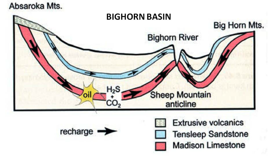
The Paleozoic aquifers in the Bighorn Basin are exposed along the surrounding mountains and provide a recharge point for water to enter the subsurface. Groundwater is heated by the Bighorn Basin geothermal gradient (16 degrees Fahrenheit/1,000 foot depth). Aquifers acquire soluble hydrogen sulfide and carbon dioxide from the sour Paleozoic oil accumulations within the basin. Groundwater rises where the aquifers are folded upward towards the surface. Flowpaths are influenced by the plumbing network created by faults, fractures, joints and karst in the Madison Formation. Movement of meteoric and ground water through the paleokarst began a new cycle of cave dissolution.
The Paleozoic aquifers in the Bighorn Basin are exposed along the surrounding mountains and provide a recharge point for water to enter the subsurface. Groundwater is heated by the Bighorn Basin geothermal gradient (16 degrees Fahrenheit/1,000 foot depth). Aquifers acquire soluble hydrogen sulfide and carbon dioxide from the sour Paleozoic oil accumulations within the basin. Groundwater rises where the aquifers are folded upward towards the surface. Flowpaths are influenced by the plumbing network created by faults, fractures, joints and karst in the Madison Formation. Movement of meteoric and ground water through the paleokarst began a new cycle of cave dissolution.
West to east model of groundwater flow in the Bighorn Basin. Springs on the west side of the Bighorn River are largely recharged from the Absaroka Mountains and flow through the oil fields of the basin. Those on the east are recharged from the Bighorn Mountains and encounter far fewer hydrocarbon accumulations (Palmer & Palmer, 2009, after Egemeier, 1981).
Audra, P. and Palmer, A.N. 2015, ACTA CARSOLOGICA 44/3, 315–348, Fig 26, p. 334.
http://ojs.zrc-sazu.si/carsologica/article/viewFile/1960/3959
Audra, P. and Palmer, A.N. 2015, ACTA CARSOLOGICA 44/3, 315–348, Fig 26, p. 334.
http://ojs.zrc-sazu.si/carsologica/article/viewFile/1960/3959
Little Mountain Cave - Horsethief Cave - Bighorn Cavern
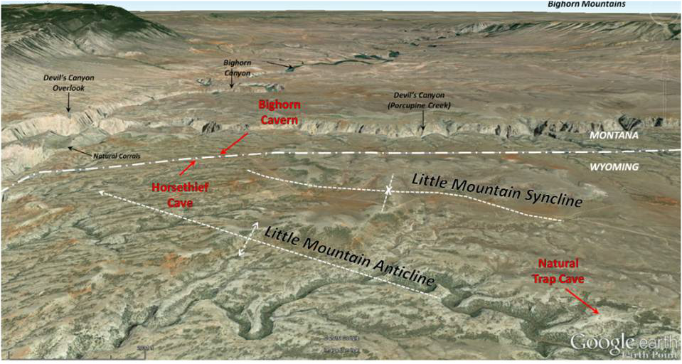
Little Mountain anticline is located on the east side of Bighorn Lake (aka Yellowtail Reservoir). It is oriented northwest between Cottonwood Canyon on the south to Devil’s Canyon at the north end. Horsethief Cave (12+ miles long) and Bighorn Cavern (8 miles long) are part of the same cave system developed along the Wyoming-Montana border near the axis of the Little Mountain structure. The system has at least 20 miles of known passage, making this the largest cave in either state. The presence of the first 700 feet of the Horsethief cave segment has probably been known since the late 19th century. The cave was named for its use by horse rustlers. There was not much law enforcement in this remote area before Big Horn County was organized in 1897 and this provided considerable incentive, and a convenient hiding place, for outlaws. At an altitude of 4,680 feet, gang lookouts at the cave mouth had a commanding view of the surrounding countryside.
North aerial view of Little Mountain caves
Google Earth Image
Google Earth Image
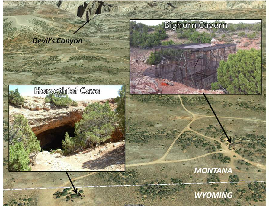
Surface view of Horsethief-Bighorn Cavern System.
Base: Google Earth Image Base; Horsethief Image: Horsethief Cave - Courtesy of wyomingcaves.blogspot.com. (2/7/2011 - Credits: Jeff Baird)
Base: Google Earth Image Base; Horsethief Image: Horsethief Cave - Courtesy of wyomingcaves.blogspot.com. (2/7/2011 - Credits: Jeff Baird)
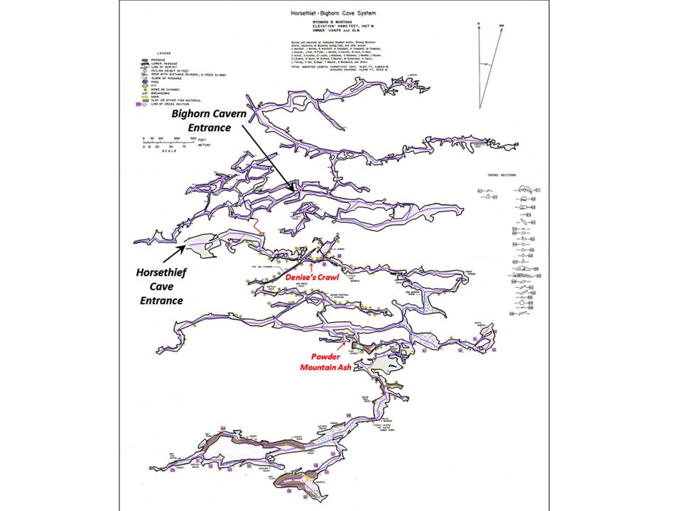
The Bighorn Cavern portion was not discovered until 1961. The cavern is located about 700 feet northeast of Horsethief on the Montana side of the border. It was originally under US Forest Service oversight, but changed to the US Park Service after becoming a National Recreation Area in 1966. The cavern begins as an 80 foot solution crevasse that connects to a network of passages and chambers. A connection to Horsethief cave (under BLM oversight) was discovered in 1968. A concrete barrier was set between the two segments early in the 1970s to separate areas overseen by different agencies. In October 1970, a Laramie caver named Denise discovered a tight passageway that led to a significant expansion of the cave length in Horsethief segment. “Denise’s Crawl” is a dusty, 100 foot long, several feet wide squeeze, whose height narrows to 15 inches in spots. This claustrophobic squeeze is the price of admission to the further reaches of the cave.
The start and end of Denise’s Crawl in Horsethief Cave. Note caver’s dust mask that is typically worn from the entry gate until passage through the crawl.
http://www.jeeppatriot.com/forum/8-sway-bar/108766-armpit-wyoming.html
http://www.jeeppatriot.com/forum/8-sway-bar/108766-armpit-wyoming.html
Timing of cave formation is usually indirectly estimated by dates acquired from sediments, fossils and pollen found within or near the entrance of the cave. This cave system probably began to form sometime in the last 650,000 years when the Bighorn River was at a higher elevation. The cave system exhibits a rectangular network of passages due to carbonic acid dissolution along east-west fracture and bedding planes in the Little Mountain structures. Smaller connecting passageways are oriented north-south. A secondary overprint of sulfuric acid is apparent from the random, interconnected solution cavities (spongework pattern) and the gypsum deposits found within the cavern. The chamber and passages have names such as C J’s Annex, Grand Central Station, Red Buddha Room, Mind Bender Pool, White Dirt Maze, Crack Where Water Comes Through and Powder Mountain.
Deposits within Horsethief Cave.
eft: limestone stalactites, stalagmites, columns and flowstone;
Center: twisted stalagmites called helectites; Right: calcite nodules of cave popcorn and gypsum flowers.http://www.bogley.com/forum/showthread.php?31033-TR-Bighorn-Cavern
eft: limestone stalactites, stalagmites, columns and flowstone;
Center: twisted stalagmites called helectites; Right: calcite nodules of cave popcorn and gypsum flowers.http://www.bogley.com/forum/showthread.php?31033-TR-Bighorn-Cavern
A conical ash bed found a half mile from the cave entrance in the “Powder Mountain room” of the cave is dated to the 640,000 year Lava Creek caldera-forming eruption of Yellowstone Park. The ash accumulated here through a former crevasse open to the surface that is now blocked by karst rubble.
The U.S. Department of Interior designated Horsethief Cave as the nation’s first Underground Recreational Trail in September of 1992.
The U.S. Department of Interior designated Horsethief Cave as the nation’s first Underground Recreational Trail in September of 1992.
Map of Horsethief-Bighorn Cave System. Map shows the eight plus miles of cave known in 1975. Currently over twenty miles of cave passages and chambers have been explored with the expectation of more to be discovered.
After Hill, C., Sutherland, W., and Tierney, L., 1976, Caves of Wyoming: Geological Survey of Wyoming [Wyoming State Geological Survey] Bulletin 59, Sheet 2. http://sales.wsgs.wyo.gov/caves-of-wyoming/
For a view inside Horsethief cave see Emily Marcus’s YouTube Video: https://www.youtube.com/watch?v=qJWRqzdfeuw
or check out Joshua Austill’s Bighorn Cavern YouTube Video: https://www.youtube.com/watch?v=E8YGRl1FF5w
Little Mountain - Natural Trap Cave (se Sec 28-T58N-R94W)
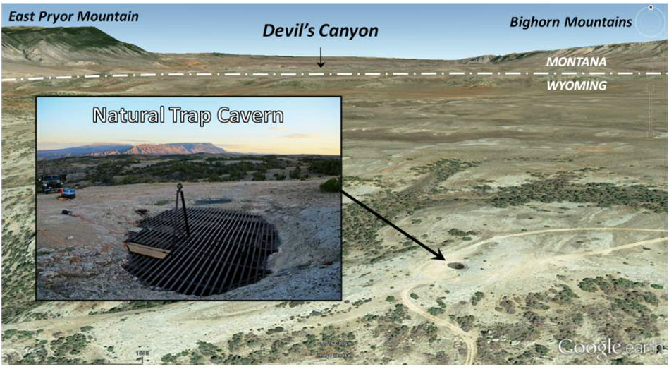
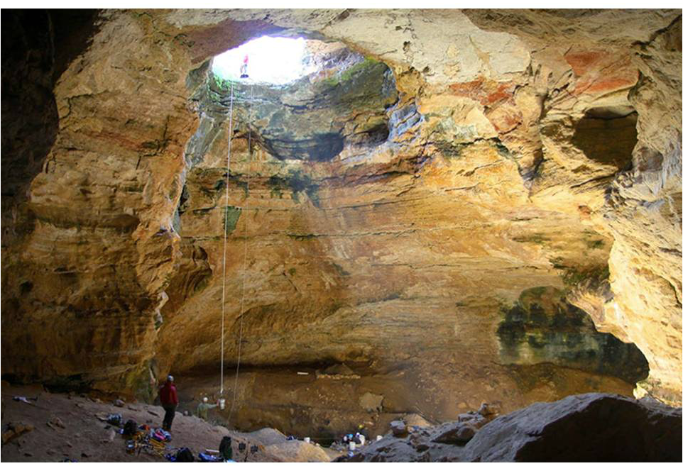
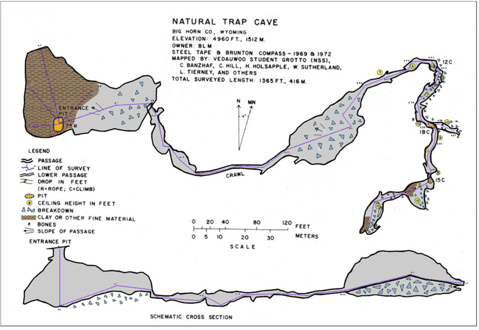
Natural Trap Cave is an 85-foot deep sinkhole that developed along a migratory trail for Pleistocene mammals. Scientists discovered the cave in 1970 and found the cave floor was covered with over 30 feet of mammal fossils. A volcanic ash layer was found at a depth of 25 feet that yielded an age of 110,000 years before present. The most likely source of the deposit is from the post-caldera eruption of the West Yellowstone rhyolite flow.
Surface view of Natural Trap Cave.
Base: Google Earth Image Base; Natural Trap Cave Image: Billings Gazette Jul 21, 2016 http://bloximages.chicago2.vip.townnews.com/billingsgazette.com/content/tncms/assets/v3/editorial/e/72/e7239587-a7fc-5ac7-a572-ad9520e480b3/578e5288612af.image.jpg?resize=1200%2C800
Base: Google Earth Image Base; Natural Trap Cave Image: Billings Gazette Jul 21, 2016 http://bloximages.chicago2.vip.townnews.com/billingsgazette.com/content/tncms/assets/v3/editorial/e/72/e7239587-a7fc-5ac7-a572-ad9520e480b3/578e5288612af.image.jpg?resize=1200%2C800
Interior view of Natural Trap Cave.
http://www.myfossil.org/featured-paleontologist-julie-meachen/
http://www.myfossil.org/featured-paleontologist-julie-meachen/
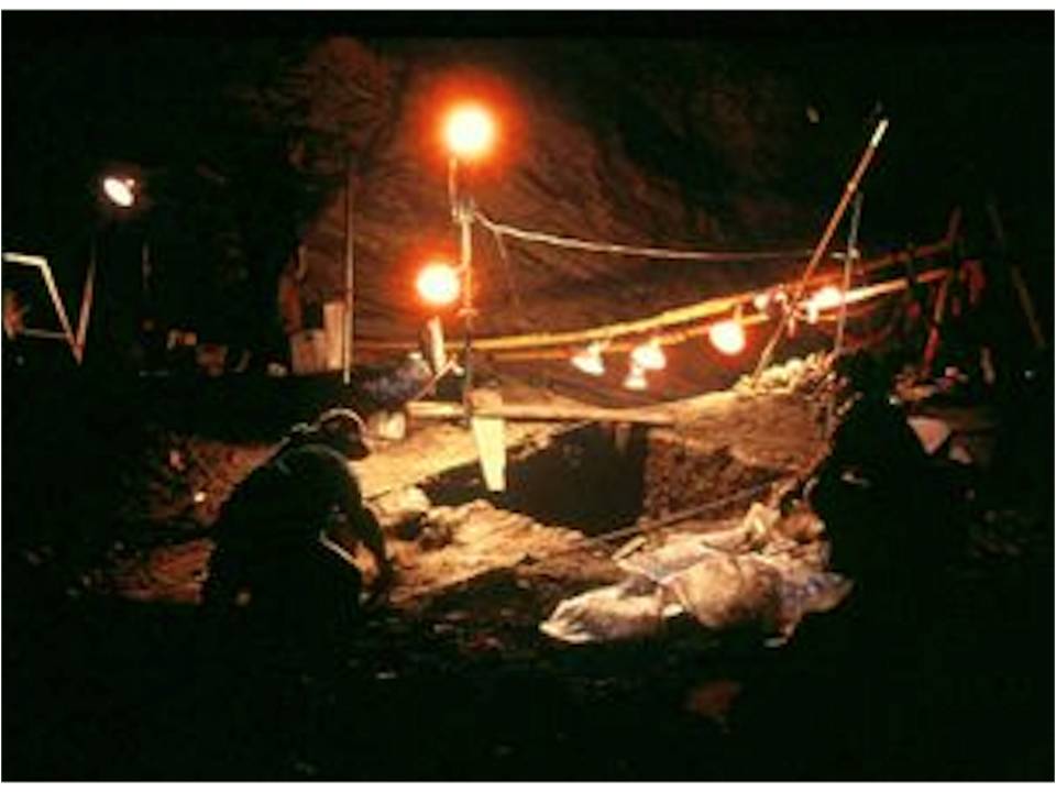
The cave is a treasure chest for researchers studying the paleontology and climatology of the Pleistocene and Holocene. The first excavations in the late 1970s and early 1980s revealed one of the largest, best preserved sites of Ice Age fossils in North America. Since 2014 scientists were able to extract DNA from the fossil remains and collect pollen and microfossils for further study. To date over 30,000 specimens have been collected. The extinct animal species include mammoth, short-faced bear, collared lemming, American lion, American cheetah, and camel. Bison, fox, bighorn sheep and pronghorn specimens have also been recovered. The cave was gated in 1973 by the BLM for safety and preservation.
Excavation at Natural Trap Cave
Image by BLM, https://www.nps.gov/bica/learn/nature/natural-trap-cave.htm
Image by BLM, https://www.nps.gov/bica/learn/nature/natural-trap-cave.htm
Map of Natural Trap Cave
Hill, C., Sutherland, W., and Tierney, L., 1976, Caves of Wyoming: Geological Survey of Wyoming [Wyoming State Geological Survey] Bulletin 59, p. 87. http://sales.wsgs.wyo.gov/caves-of-wyoming/
Hill, C., Sutherland, W., and Tierney, L., 1976, Caves of Wyoming: Geological Survey of Wyoming [Wyoming State Geological Survey] Bulletin 59, p. 87. http://sales.wsgs.wyo.gov/caves-of-wyoming/
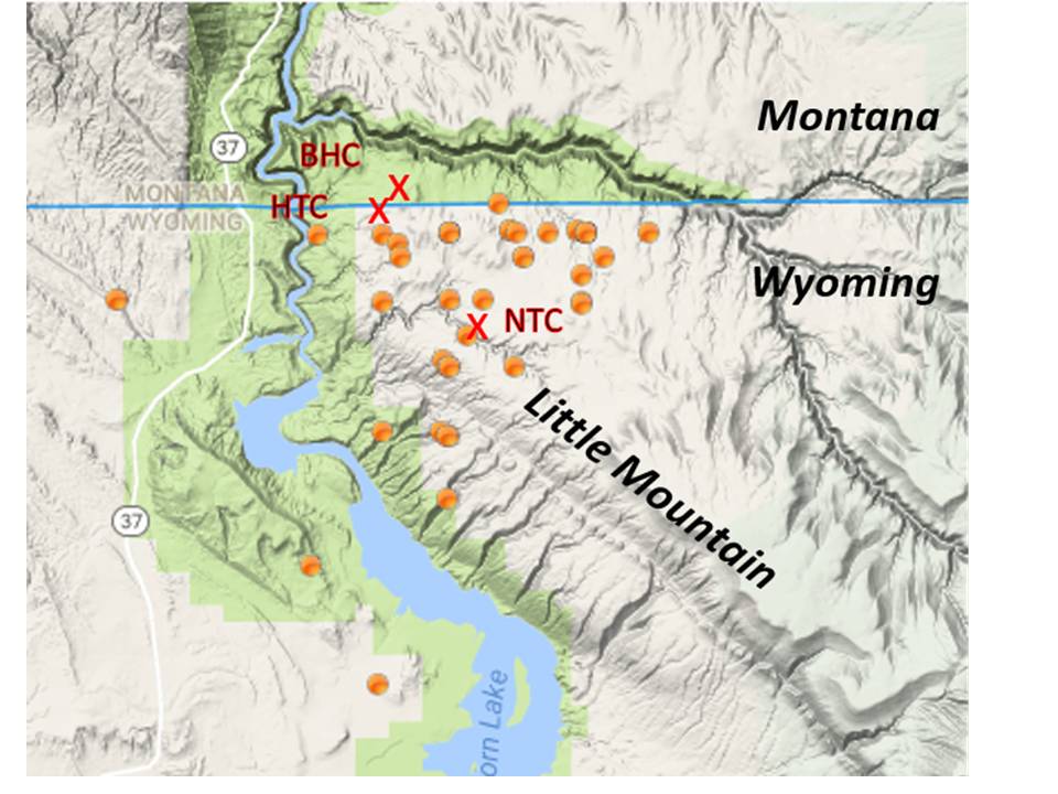
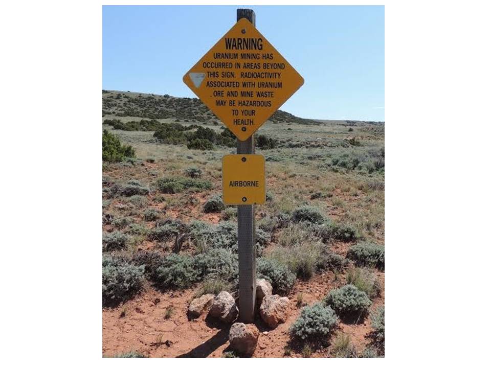
Uranium minerals and radon gas are present throughout the Little Mountain area. Multiple uranium pits and mines occur near these caves. The radioactive minerals accumulated within the breccia zones of the Upper Madison paleokarst. The recommended cumulative time in these caves is a maximum of 180 hours annually due to radiation exposure risks.
Little Mountain area uranium mines. BHC: Bighorn Caverns; HTC: Horsethief Cave; NTC: Natural Trap Cave; Red x: Cave location; Yellow dot: Uranium mine.
After http://www.us-mining.com/wyoming/big-horn-county/uranium-mines
After http://www.us-mining.com/wyoming/big-horn-county/uranium-mines
Mine Hazard Warning Sign
https://petypeshift.blob.core.windows.net/attachments/c910c9c6-cfea-4087-9a0b-05ff4b33434d.jpg
https://petypeshift.blob.core.windows.net/attachments/c910c9c6-cfea-4087-9a0b-05ff4b33434d.jpg
The Australian Centre for Ancient DNA uploaded a look inside Natural Trap Cave:
https://www.youtube.com/watch?v=JNiSA11mWY8
https://www.youtube.com/watch?v=JNiSA11mWY8
Little Sheep Mountain - Kane Caves
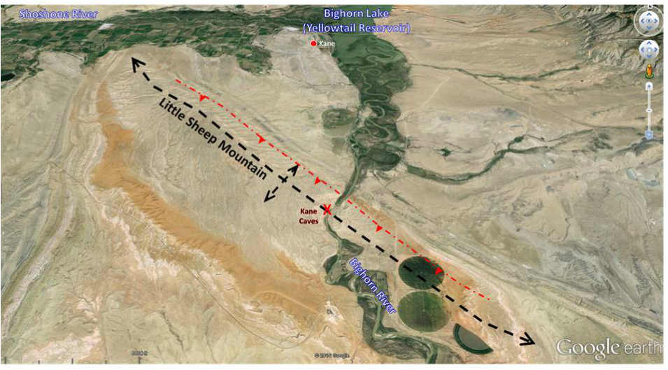
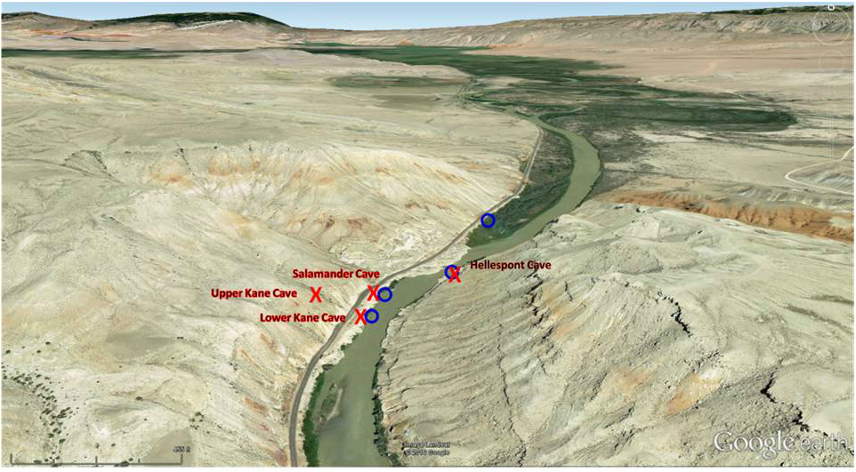
Little Sheep Mountain is a Laramide asymmetrical anticline located about 19 miles south of the Horsethief-Bighorn Cavern system on Little Mountain. The anticline is oriented northwest-southeast with a buried thrust fault on its northeastern flank. The Kane caves are all single passage, relatively short length solution caves that trend along fractures oriented perpendicular to the fold axis. The four caves and their lengths are: Hellespont: 65 feet (aka Coon Odor), Salamander: less than 10 feet, Upper Kane: 950 feet, and Lower Kane: 1,060 feet.
North aerial view of Little Sheep Mountain anticline. Fold axis: black dashed line; blind thrust fault: red dashed line; Kane Caves area: red X
Google Earth Image
Google Earth Image
Close-up view of Kane Caves area developed on the axis of Little Sheep Mountain anticline. Cave: red X; Hot Spring: blue circle.
Google Earth Image
Google Earth Image
Hellespont Cave (aka Coon Odor Cave)
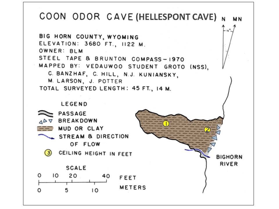
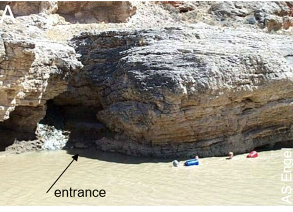
This is an active, wet, sulfuric acid cave. A hot spring flows 67 degree Fahrenheit water at 100 gallons per minute from the rear of the cave. The “Coon Odor” name comes from the rotten egg smell of the poisonous hydrogen sulfide gas (H2S). Cavers can experience H2S exposure symptoms within a few hours. The cave is used for research on cave microorganisms and sulfuric acid speleogenesis.
Map of Coon Odor Cave (Hellespont Cave)
After Hill, C., Sutherland, W., and Tierney, L., 1976, Caves of Wyoming: Geological Survey of Wyoming [Wyoming State Geological Survey] Bulletin 59, p. 90. http://sales.wsgs.wyo.gov/caves-of-wyoming/
After Hill, C., Sutherland, W., and Tierney, L., 1976, Caves of Wyoming: Geological Survey of Wyoming [Wyoming State Geological Survey] Bulletin 59, p. 90. http://sales.wsgs.wyo.gov/caves-of-wyoming/
Entrance to Hellespont Cave
Engel, A.S., 2004, Geomicrobiology of Sulfuric Acid Speleogenesis: Microbial Diversity, Nutrient Cycling, and Controls on Cave Formation: Ph.D. Dissertation, University of Texas at Austin, Appendix B, Fig. B-1A, p. 283.
Engel, A.S., 2004, Geomicrobiology of Sulfuric Acid Speleogenesis: Microbial Diversity, Nutrient Cycling, and Controls on Cave Formation: Ph.D. Dissertation, University of Texas at Austin, Appendix B, Fig. B-1A, p. 283.
Salamander Cave
Little is known about this cave due to the ceiling collapse rockfall blocking the short passage. One interesting note is that a freshwater, spring flows 62 degree Fahrenheit water at over 1,300 gallons per minute from the blockage.
Lower Kane Cave
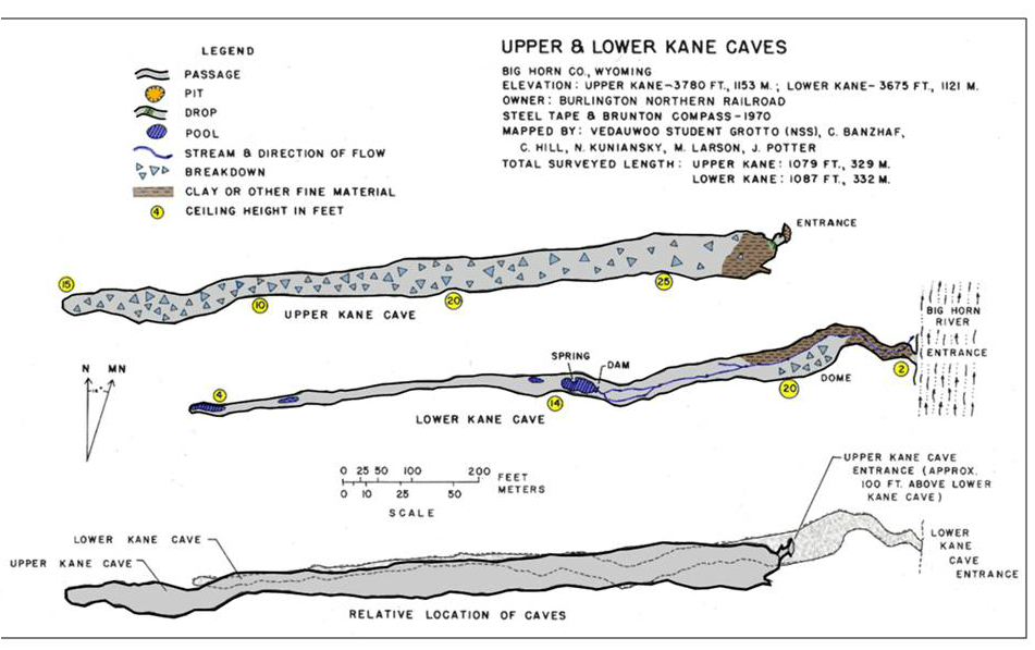
This active cave is the largest of the Kane Caves. Egemeier (1973) made the first detailed report of sulfuric acid speleogenesis from his study of Lower Kane and Hellespont caves. This same hypogenic process shaped the Horsethief-Bighorn system 19 miles to the north on Little Mountain and the Spence Cave 10 miles to the south on Sheep Mountain. Recent research has focused on the microbiology of sulfuric acid caves. Engel (2004) identified the same biota (Epsilonprotobacteria) in the subaqueous microbial mats that was first discovered at deep-sea hydrothermal vents in 1977 (East Pacific Rise “black smokers“). These microorganisms are able to extract energy from an inorganic source in an anaerobic environment. The age of the cave has not been determined but terraces developed near the mouth of the cave give an estimated age range between 40 and 160 thousand years ago. Because the cave area is much greater than Hellespont, hydrogen sulfide exposure symptoms can take nine hours to appear.
Upper Cane Cave
Upper Kane Cave is an inactive cave about 100 feet above Lower Kane Cave. Limestone dissolution occurred by the same process observed in the lower cave. There are gypsum deposits on the walls and floor. There are few places in the world where active sulfuric acid caves can easily be studied. The Kane Caves offer researchers a tandem pair of active and inactive sulfuric acid caves at an easily accessible location.
Map of Upper and Lower Kane Caves
After Hill, C., Sutherland, W., and Tierney, L., 1976, Caves of Wyoming: Geological Survey of Wyoming [Wyoming State Geological Survey] Bulletin 59, p. 91. http://sales.wsgs.wyo.gov/caves-of-wyoming/
After Hill, C., Sutherland, W., and Tierney, L., 1976, Caves of Wyoming: Geological Survey of Wyoming [Wyoming State Geological Survey] Bulletin 59, p. 91. http://sales.wsgs.wyo.gov/caves-of-wyoming/
A 2002 NOVA program “The Mysterious Life of Caves” presented a segment on the Kane Caves: http://www.pbs.org/wgbh/nova/education/earth/cave-formation-kane.html
Sheep Mountain - Spence Cave
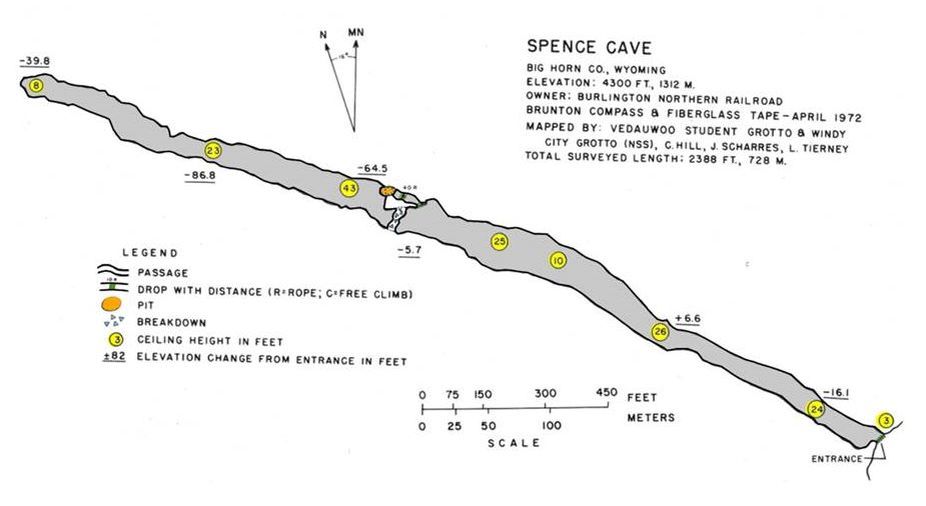
Sheep Mountain is a Laramide asymmetric, faulted anticline located just north of Greybull, Wyoming. The Bighorn River has carved a canyon through the structure perpendicular to the fold axis. Spence Cave is an inactive, dry cave located 390 feet above the Bighorn River in the Upper Madison Formation. The cave formed by sulfuric acid dissolution at a time when the Bighorn River was near the cave mouth level. Gypsum deposits within the cave and a sulfuric hot spring at river level suggest this conclusion. The age of an eolian (windblown) sand deposit at the mouth of the cave indicates the cave is older than 310,000 years.
Map of Spence Cave located in the canyon dissecting Sheep Mountain
After Hill, C., Sutherland, W., and Tierney, L., 1976, Caves of Wyoming: Geological Survey of Wyoming [Wyoming State Geological Survey] Bulletin 59, p. 91. http://sales.wsgs.wyo.gov/caves-of-wyoming/
After Hill, C., Sutherland, W., and Tierney, L., 1976, Caves of Wyoming: Geological Survey of Wyoming [Wyoming State Geological Survey] Bulletin 59, p. 91. http://sales.wsgs.wyo.gov/caves-of-wyoming/
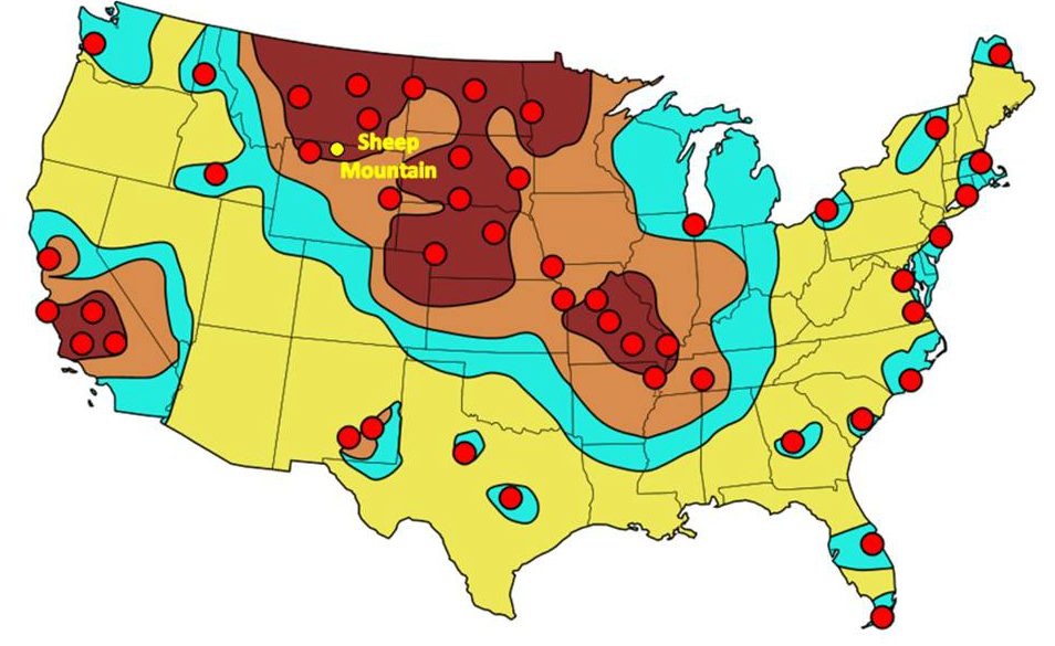
Spence Cave served as a Bighorn County fallout shelter in the 1950s. This shelter requires a 390 foot near-vertical climb in less than the 30 minutes it would take a Russian ICBM to reach the United States.
FEMA-estimated primary counterforce targets for Soviet ICBMs in 1990 (red dots). The resulting fall-out is indicated with the darkest considered as lethal to lesser fall-out yellow zones. Spence Cave fallout shelter at Sheep Mountain shown by yellow dot. After https://en.wikipedia.org/wiki/Nuclear_warfare#/media/File:US_nuclear_strike_map.svg
One can imagine the citizens of Greybull scrambling up Sheep Mountain to reach the cave shelter within allotted time. Isaiah 2:19 captures this panicked flight from a nuclear holocaust:
"And they shall go into the holes of the rocks, and into the caves of the earth, for fear of the LORD, and for the glory of his majesty, when he rises to shake terribly the earth."
Fallout Shelter sign
https://upload.wikimedia.org/wikipedia/commons/thumb/a/ae/United_States_Fallout_Shelter_Sign.svg/2000px-United_States_Fallout_Shelter_Sign.svg.png
https://upload.wikimedia.org/wikipedia/commons/thumb/a/ae/United_States_Fallout_Shelter_Sign.svg/2000px-United_States_Fallout_Shelter_Sign.svg.png
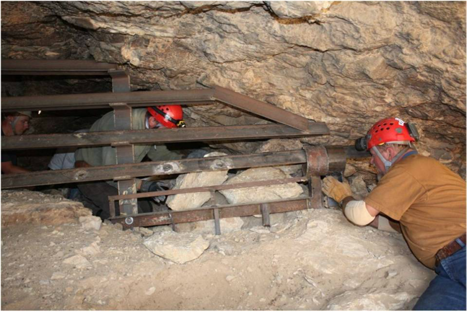
The Federal Cave Protection Act of 1988 provided protection for caves and their biota on Federal land. Bats gained legal protection in Wyoming in 1994. Several species of bats are known to use Spence Cave for hibernation and as a summer roosting site. A bat-friendly gate was erected in 1999 for protection.
The 1999 instillation of bat-friendly gate at Spence Cave
Image: BLM
Image: BLM
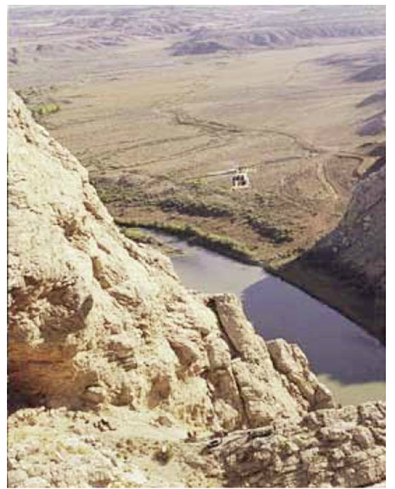
Construction of the Spence Cave bat gate required helicopter support due to its remote location. This is the height above the river to reach the fallout shelter.
Bob Luce, 2000, Wyoming Game and Fish Department Image in Bat Conservation International Annual Report 1999-2000, 1999 Photo, P. 5.
Bob Luce, 2000, Wyoming Game and Fish Department Image in Bat Conservation International Annual Report 1999-2000, 1999 Photo, P. 5.
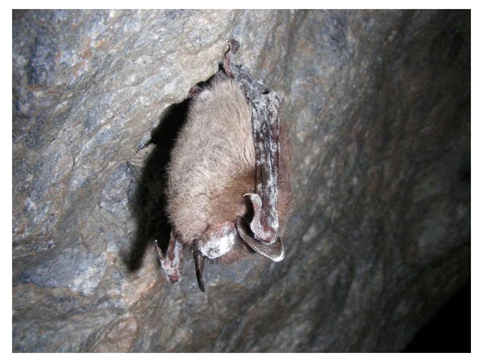
Many of the caves in the Bighorn River area provide habitat for bats. An inventory of the Bighorn Canyon Recreation Area identified 12 bat species within the region. The state recently issued an alert for all cavers to take precautions to prevent the spread of “White Nose Syndrome.” This fungus is responsible for millions of bat deaths and is slowly spreading westward across the country. Scientists estimate it could reach Wyoming in the next dozen years.
Townsend’s big-eared bat with white nose syndrome.
Image: BLM
Image: BLM
Things To Do Bighorn River Area Caves
Because of safety and health concerns, we are not recommending a visit into any of the caves. The Little Mountain area east of Bighorn Lake is a scenic place to explore and has the entrances to Bighorn Cave, Horsethief Cave and Natural Trap Cave. However, the John Blue Road that accesses Little Mountain is too rough for most vehicles. There is not enough ground clearance on most vehicles because of the massive road bars to divert water. We would describe Little Mountain as ATV country, not SUV country.
Cottonwood Canyon Hike
We are recommending a scenic hike up Cottonwood Canyon which is accessible with a passenger vehicle when dry. A short section of the Cottonwood Canyon access road crosses some bentonite clay that is nasty and rutted if wet. The trail starts at the mouth of the Canyon with an impressive mountain front fold of Madison Formation. As advertised, the stream has cottonwood trees with the water disappearing and appearing multiple times into the Madison and Bighorn carbonates. Early explorers were not always original in naming creeks. We suspect there is a Cottonwood Creek in every county in Wyoming. First two miles of trail is along the remains of a road and then the trail becomes narrower, steeper and more rocky. There is a waterfall on the cliff face to the right at about 1.2 miles up the trail. Enjoy this isolated and pretty canyon!
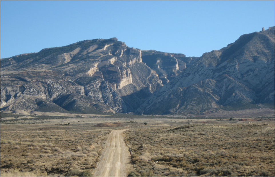
Cottonwood Canyon and access road.
Photo by Mark Fisher
Photo by Mark Fisher
Directions to Cottonwood Canyon
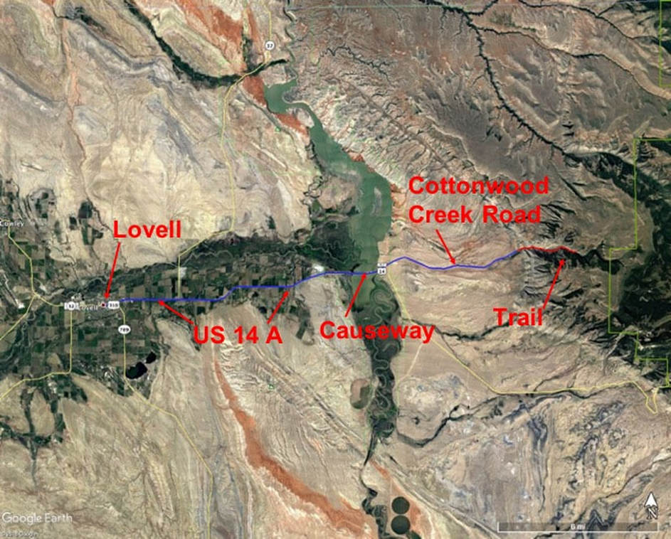
Starting at the only traffic light in downtown Lovell at the intersection of Main (US 14A, US 310) and Nevada, go east on US 14A toward Greybull, 0.5 miles turn left on US 14A heading east to Burgess Junction, 0.6 miles Bighorn Canyon National Recreation Area Visitor Center on right, 0.8 miles Mustang Visitor Center on right, 2.9 miles intersection WY 37 to Bighorn Canyon on left, 9.2 miles railroad crossing and start of causeway over Bighorn Lake, 10.6 miles bridge, 10.8 miles turn left off highway onto gravel Big Horn County Road, 10.9 miles road splits take right on Cottonwood Creek Road, 11.6 miles BLM kiosk, 16.4 miles park for Cottonwood Canyon trailhead.
Hike details: 0.0 miles parking area, fence & gate, 0.2 miles first resistant layer on left is Permian Phosphoria Formation composed of dolomites and shales, second resistant layer which forms ridge on left is Pennsylvanian Tensleep Sandstone, 0.3 miles small side valley on left is Pennsylvanian Amsden red shale, 0.4 miles fence, gate, top of Mississippian Madison Formation dipping about 45 degrees to west at mouth of canyon, 0.5 miles cliff next to road is Madison, 0.6 miles water in creek disappears into Madison near contact at base of Madison and top Devonian Jefferson/Three Forks shales and carbonates, 0.8 miles top of Bighorn Formation, cliff above creek to right is Bighorn, 0.9 miles fence and gate, 1.0 miles base of Bighorn cliff on left, contact with top of Cambrian shales which forms covered slope, 1.1 miles cross creek, 1.2 miles waterfall above on right in Lower Bighorn, 1.4 miles Bighorn and other formations flatten and become horizontal, on the south side of the Canyon wall between the upper cliff that is Madison and the lower cliff that is Bighorn is a red resistant layer of Devonian Beartooth Butte Formation, 2.1 miles cross creek several times near base of Bighorn, trail becomes steeper and more rocky, 2.3 miles base of Bighorn, I turned around at this point and had climbed about 1,400 vertical feet from the car in 1-1/2 hours. The trail continues a couple more miles up the canyon. I did not see any rattlesnakes, but you should be cautious and look out for them. You will want to time your visit to avoid mid-day summer heat.
Hike details: 0.0 miles parking area, fence & gate, 0.2 miles first resistant layer on left is Permian Phosphoria Formation composed of dolomites and shales, second resistant layer which forms ridge on left is Pennsylvanian Tensleep Sandstone, 0.3 miles small side valley on left is Pennsylvanian Amsden red shale, 0.4 miles fence, gate, top of Mississippian Madison Formation dipping about 45 degrees to west at mouth of canyon, 0.5 miles cliff next to road is Madison, 0.6 miles water in creek disappears into Madison near contact at base of Madison and top Devonian Jefferson/Three Forks shales and carbonates, 0.8 miles top of Bighorn Formation, cliff above creek to right is Bighorn, 0.9 miles fence and gate, 1.0 miles base of Bighorn cliff on left, contact with top of Cambrian shales which forms covered slope, 1.1 miles cross creek, 1.2 miles waterfall above on right in Lower Bighorn, 1.4 miles Bighorn and other formations flatten and become horizontal, on the south side of the Canyon wall between the upper cliff that is Madison and the lower cliff that is Bighorn is a red resistant layer of Devonian Beartooth Butte Formation, 2.1 miles cross creek several times near base of Bighorn, trail becomes steeper and more rocky, 2.3 miles base of Bighorn, I turned around at this point and had climbed about 1,400 vertical feet from the car in 1-1/2 hours. The trail continues a couple more miles up the canyon. I did not see any rattlesnakes, but you should be cautious and look out for them. You will want to time your visit to avoid mid-day summer heat.
Map to Cottonwood Canyon, access route in blue and hike in red
Google Earth image
Google Earth image
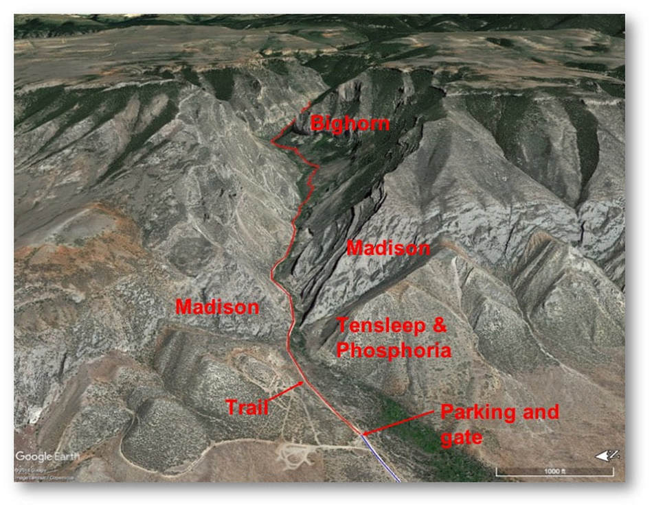
View to east of Cottonwood Canyon with hike in red
Google Earth image
Google Earth image

The material on this page is copyrighted


