Wow Factor (3 out of 5 stars):
Geologist Factor (2 out of 5 stars):
Attraction
Abandoned uranium mining district in the Shirley Basin
Shirley Basin Uranium Mining and Geology
Shirley Basin townsite was a remote uranium mining camp located about 40 miles south of Casper on the isolated grasslands of south-central Wyoming. It is a desolate, blustery sagebrush landscape at 7,100 foot above sea level, where winter wind chills can reach 100 degrees below zero. Molly Ivins described the town as ''a moonscape capped with snow, a huge clot of trailers, one after another, and nothing else'' (Ivins, M., March 21, 1978, New York Times). Ivins’ article inspired the off-off-Broadway comedy play “Shirley Basin” about the women of the uranium mining town.
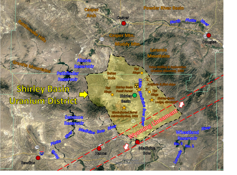
Region surrounding Shirley Basin (black dashed line) and the abandoned mining community of the same name (green dot). The mining boom ended, and the town was abandoned in 1992. Basin sites of interest are shown by gold stars.
Image: Google Earth
Image: Google Earth
Shirley Basin (not the townsite) is a northwest trending asymmetric basin that formed by subduction-driven Late Cretaceous to early Tertiary tectonism called the Laramide Orogeny. Laramide structuring created the basement cored uplifts that surround the basin. The basin is named for the Shirley Mountains that lie on the southwestern margin. The mountains were named after freighter John Shirley who hauled supplies to homesteaders there in the mid-1800’s (Shirley’s Mountains). The Granite Mountains (aka Sweetwater Arch) lie to the west and Bates Hole, a prominent erosional feature drained by Stinking Creek, is the north margin of the basin. The Laramie Range marks the northeastern and eastern border. Northeast-trending Flat Top anticline is the basin’s structural divide with the Laramie Basin to the south. This feature is part of the Wyoming Lineament which is a broad zone of east northeast-trending folds above a major Precambrian shear zone in central Wyoming formed during the assembly of the Wyoming Craton (Ransome, 1915, Blackstone, 1983).
Uranium deposits in the Eocene Wind River Formation were discovered by Teton Exploration in 1955. The leasing boom took off in 1957 with several companies acquiring leases. Utah Mining began underground mining in 1959 in the northwestern part of the district. In 1964 they converted to in-situ recovery (ISR). This was the first use of the ISR uranium mining technique in the United States. After 1968, Utah Mining began strip mining of the ore. Uranium ore was shipped to the Lucky Mc mill in the Gas Hills, 145 miles west, before an onsite mill was constructed in 1969. The mill began operations in 1971. Since the 1990s all uranium mining in Wyoming uses the ISR process (also called in-situ leach, ISL).
Petrotomics began strip mining in the southern portion of the district in 1960. The company was a partnership between Kerr-McGee Oil Industries, Inc., Getty Oil Company, Skelly Oil Company and Tidewater Oil Company. Ore was processed offsite until a 500-ton per day mill was constructed in 1962.
The district produced 18,080,489 tons of uranium ore from 1959 to 1992. Petrotomics housed workers in onsite sleeping quarters while Utah Mining housed its workers in a nearby trailer site named Shirley Basin. The camp was relocated in 1970 from its original location adjacent to the mines to make room for a Utah Mining mill and mining of additional ore deposits by Petrotomics. The new townsite was about six miles south of mine operations.
Shirley Basin Uranium District operations and townsite.
Image: Google Earth; Utah Mining Mill: https://www.fluor.com/projects/uranium-processing-engineering-construction; Petrotomics Mill: Elmer J. Garbella, 1968, The Petrotomics Company Uranium Mine and Plant, Shirley Basin, Wyoming: Bulletin No. M4-B136; https://www.amazon.com/Petrotomics-Company-Uranium-Shirley-Wyoming/dp/B000UPJPBU; Townsite: Lane, T.J., 2017, Shirley Basin Wyoming; https://www.youtube.com/watch?v=F6uCD9HShZg&app=desktop.
Image: Google Earth; Utah Mining Mill: https://www.fluor.com/projects/uranium-processing-engineering-construction; Petrotomics Mill: Elmer J. Garbella, 1968, The Petrotomics Company Uranium Mine and Plant, Shirley Basin, Wyoming: Bulletin No. M4-B136; https://www.amazon.com/Petrotomics-Company-Uranium-Shirley-Wyoming/dp/B000UPJPBU; Townsite: Lane, T.J., 2017, Shirley Basin Wyoming; https://www.youtube.com/watch?v=F6uCD9HShZg&app=desktop.
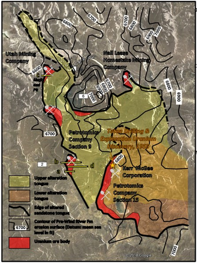
Shirley Basin Mining District showing upper (yellow) and lower (brown) sand tongues in the Wind River Formation, ore bodies (red), structure contours on Cretaceous/Tertiary unconformity surface (black lines), mines (pick and shovel symbol) and cross sections (yellow lines a-d). Ore bodies overlap in the south-central portion of the district (orange).
Image: Google Earth; Data: After Harshman, E.N., Geology and Uranium Deposits, Shirley Basin Area, Wyoming: U.S. Geological Survey Professional Paper 745, Fig. 27, p. 45; https://pubs.usgs.gov/pp/0745/report.pdf.
Image: Google Earth; Data: After Harshman, E.N., Geology and Uranium Deposits, Shirley Basin Area, Wyoming: U.S. Geological Survey Professional Paper 745, Fig. 27, p. 45; https://pubs.usgs.gov/pp/0745/report.pdf.
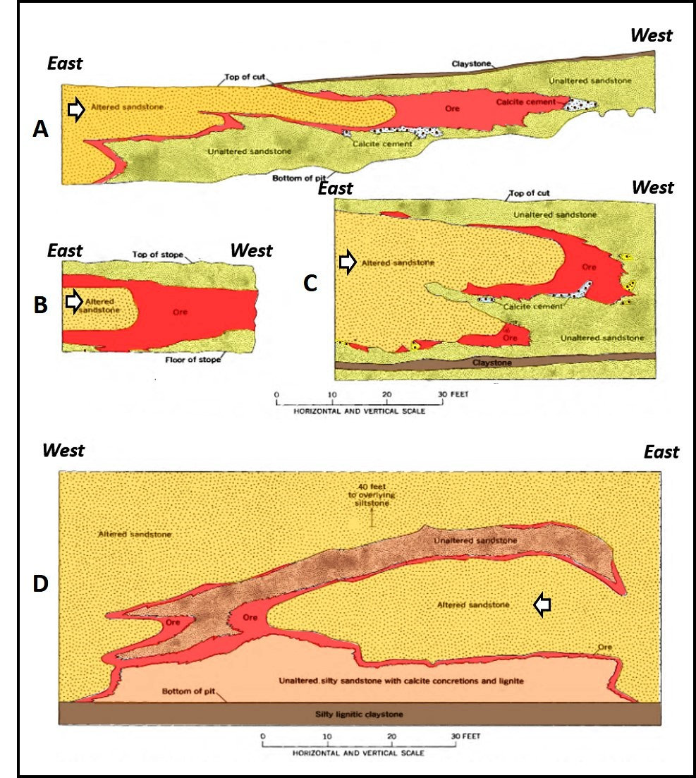
Cross sections displaying roll-front geometry in sandstones of the Wind River Formation, Shirley Basin Uranium District. Cross section locations shown on previous image. Oxidized uranium-bearing groundwater flowed from east to west in all sections (white arrows). Ore bodies shown in red.
Image: Google Earth; Data: After Harshman, E.N., Geology and Uranium Deposits, Shirley Basin Area, Wyoming: U.S. Geological Survey Professional Paper 745, Fig. 27, p. 51; https://pubs.usgs.gov/pp/0745/report.pdf.
Image: Google Earth; Data: After Harshman, E.N., Geology and Uranium Deposits, Shirley Basin Area, Wyoming: U.S. Geological Survey Professional Paper 745, Fig. 27, p. 51; https://pubs.usgs.gov/pp/0745/report.pdf.
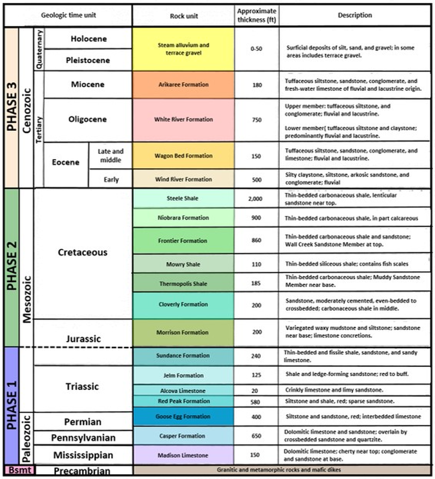
Precambrian crystalline basement of the Wyoming craton underlies the Phanerozoic section (Paleozoic to Cenozoic eras) in Shirley Basin. (The Precambrian time covers the first 4 billion years of earth history.) Phase 1 stratigraphy records the next 380 million years of deposition on the Wyoming shelf. Phase 2 lasts the next 90 million years is represented by strata deposited in the Sevier foreland basin and the Western Interior Seaway. Phase 3 stratigraphy chronicles 70 million years of Laramide and post-Laramide deposition.
The Shirley, Hanna and Laramie Basins were part of a single continuous basin area in the Sevier foreland prior to the Laramide Orogeny. At the outset of Laramide mountain building, the area was divided into separate intermontane basins by uplifts. The Phase 1 and 2 units (more than 6,300 feet thick) were tilted, folded, eroded, and developed an angular unconformity on pre-Tertiary rocks. The erosional topography influenced the deposition of nearly flat-lying Tertiary sediments (dip: < 2 degrees to the northeast). Eastward flowing streams were diverted northwestward by topography and dropped their sediment load. Sandstones in the Wind River Formation are the primary host of uranium deposits in the Shirley Basin. Organic material from the Eocene Forests were deposited in the Wind River Sandstones. This organic material supplied the reducing chemical environment to develop roll-fronts from the uranium-bearing groundwater. The claystone of the upper Wind River Formation and the underlying Cretaceous Steele and Niobrara Shales were the confining units for the ore bodies.
The uranium source for the ore deposits in the Wind River Formation is most likely from granitic rocks and arkosic material from the Granite, Shirley, and Laramie Mountains. Some uranium may have come from the volcanic ash in the overlying White River Formation. The roll-front model of uranium ore deposition (Love, J.D., 1952, Preliminary Report on Uranium Deposits in the Pumpkin Buttes Area, Powder River Basin, Wyoming: U.S. Geological Survey Circular 176) was enhanced and successfully applied by Utah Mining for uranium exploration and mining in the Northern Uranium District (See https://www.geowyo.com/gas-hills--crooks-gap-uranium.html).
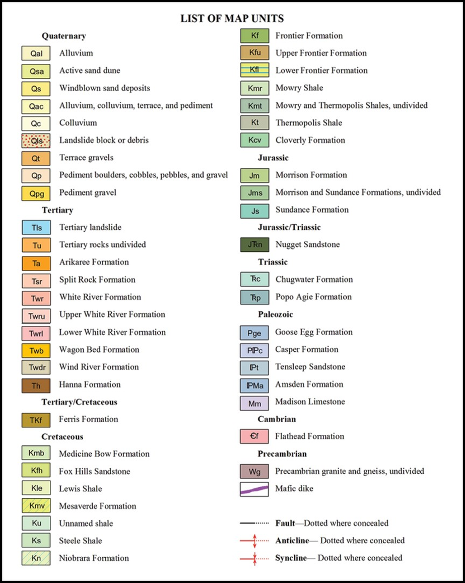
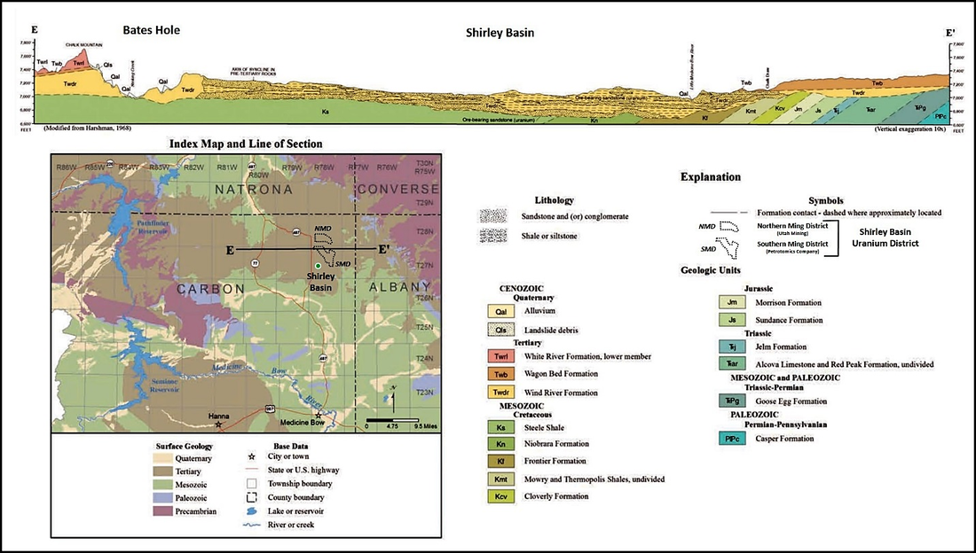
Geologic map and index of Shirley Basin Mining District. Map area is the same as shown in “Shirley Basin Uranium District operations and townsite“ image above. Gray shaded areas show mine and tailings pits in the district. Structural cross section EE’’ location shown (black line). Large area to north in subtle pink is Tertiary Upper White River Formation, large area in brighter pink at Utah International is Tertiary Lower White River Formation, bright orange area to east is Tertiary Wagon Bed Formation, large mud colored area to south is Tertiary Wind River Formation and light green area to northwest and southwest is Cretaceous Steele Shale.
Image: After Jones, N.R., and Gregory, R.W., 2011, Preliminary geologic map of the Shirley Basin 30’ x 60’ quadrangle, Carbon, Natrona, Albany, and Converse counties, Wyoming: Wyoming State Geological Survey Open File Report 11-8, scale 1:100,000; https://www.wsgs.wyo.gov/products/wsgs-2011-ofr-08.pdf.
Image: After Jones, N.R., and Gregory, R.W., 2011, Preliminary geologic map of the Shirley Basin 30’ x 60’ quadrangle, Carbon, Natrona, Albany, and Converse counties, Wyoming: Wyoming State Geological Survey Open File Report 11-8, scale 1:100,000; https://www.wsgs.wyo.gov/products/wsgs-2011-ofr-08.pdf.
Structural cross section EE’, Shirley Basin area. Section is oriented west to east. Note the angular erosional surface (unconformity) between the underlying dipping Mesozoic and Paleozoic rocks and the overlying flat Tertiary rocks.
Image: After Ver Ploeg, A., Taboga, K., and Taucher, P., 2013, Chapter 4: Geologic Setting in Platte River Basin Water Plan Update Groundwater Study Level 1 (2009 - 2013) Available Groundwater Determination, Technical Memorandum, Fig. 4-6, p. 4-38; http://waterplan.state.wy.us/plan/platte/2013/gw-finalrept/gw-ch04.pdf.
Image: After Ver Ploeg, A., Taboga, K., and Taucher, P., 2013, Chapter 4: Geologic Setting in Platte River Basin Water Plan Update Groundwater Study Level 1 (2009 - 2013) Available Groundwater Determination, Technical Memorandum, Fig. 4-6, p. 4-38; http://waterplan.state.wy.us/plan/platte/2013/gw-finalrept/gw-ch04.pdf.
Shirley Basin stratigraphic chart.
Image: After Harshman, E.N., Geology and Uranium Deposits, Shirley Basin Area, Wyoming: U.S. Geological Survey Professional Paper 745, Table 1, p. 10; https://pubs.usgs.gov/pp/0745/report.pdf.
Image: After Harshman, E.N., Geology and Uranium Deposits, Shirley Basin Area, Wyoming: U.S. Geological Survey Professional Paper 745, Table 1, p. 10; https://pubs.usgs.gov/pp/0745/report.pdf.
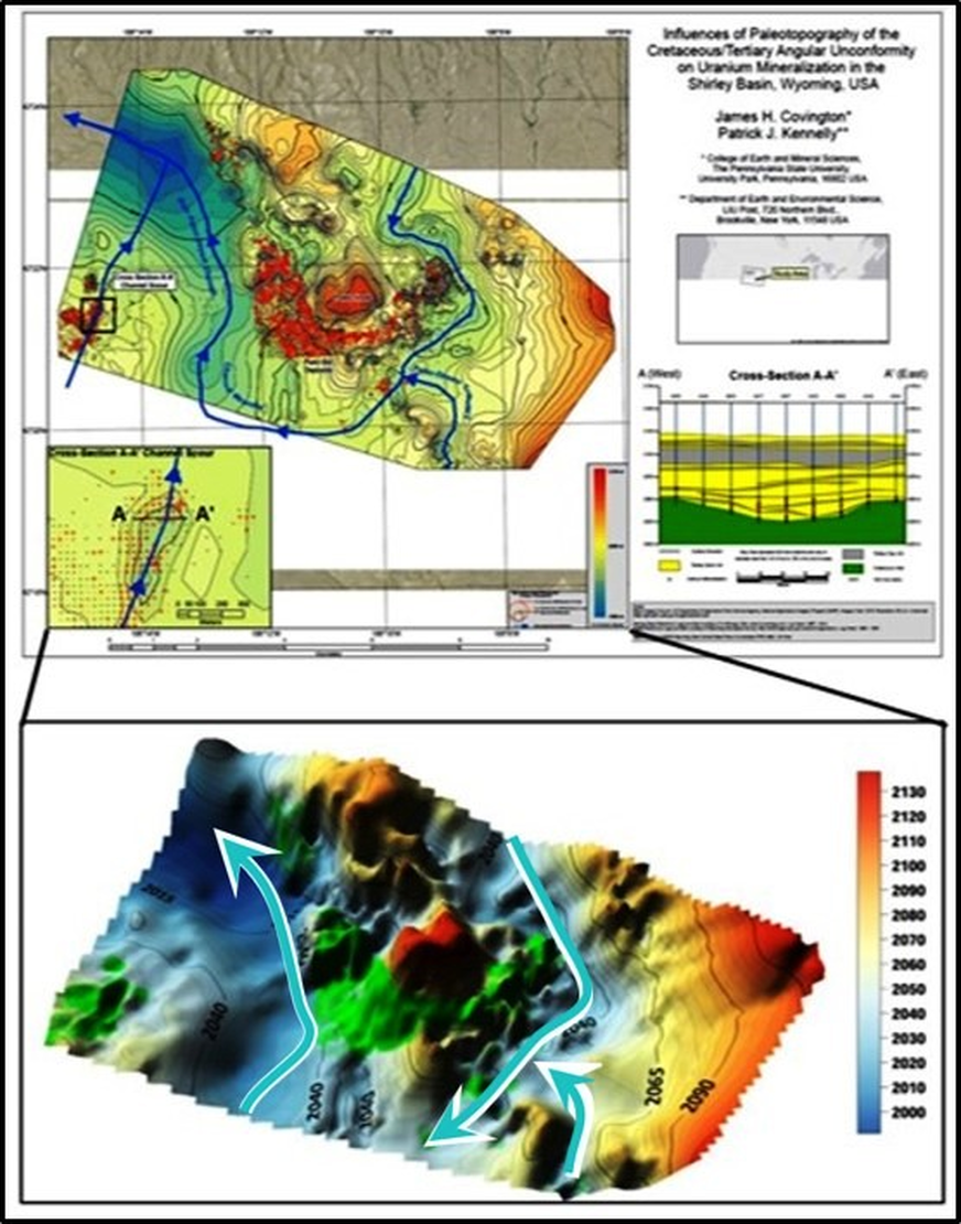
Paleotopography of the Cretaceous/Tertiary angular unconformity and influences on Eocene stream flow, Shirley Basin. Top: Uranium well – red dots; Stream channel – blue line; Bottom: Economic or ‘ore’ drill holes with Grade Thickness greater than or equal to 0.30 grade thickness (Average grade of uranium intercepts in % x Average thickness of uranium intercepts in ft) – green; major channel flow direction - light blue arrows.
Image: After Covington, J.H., and Kennelly, P., 2018, Paleotopographic influences of the Cretaceous/Tertiary angular unconformity on uranium mineralization in the Shirley Basin, Wyoming: Journal of Maps, Vol. 14, Issue 2, Supplemental material and Fig. 7, p. 594; https://www.tandfonline.com/doi/pdf/10.1080/17445647.2018.1512014?needAccess=true.
Image: After Covington, J.H., and Kennelly, P., 2018, Paleotopographic influences of the Cretaceous/Tertiary angular unconformity on uranium mineralization in the Shirley Basin, Wyoming: Journal of Maps, Vol. 14, Issue 2, Supplemental material and Fig. 7, p. 594; https://www.tandfonline.com/doi/pdf/10.1080/17445647.2018.1512014?needAccess=true.
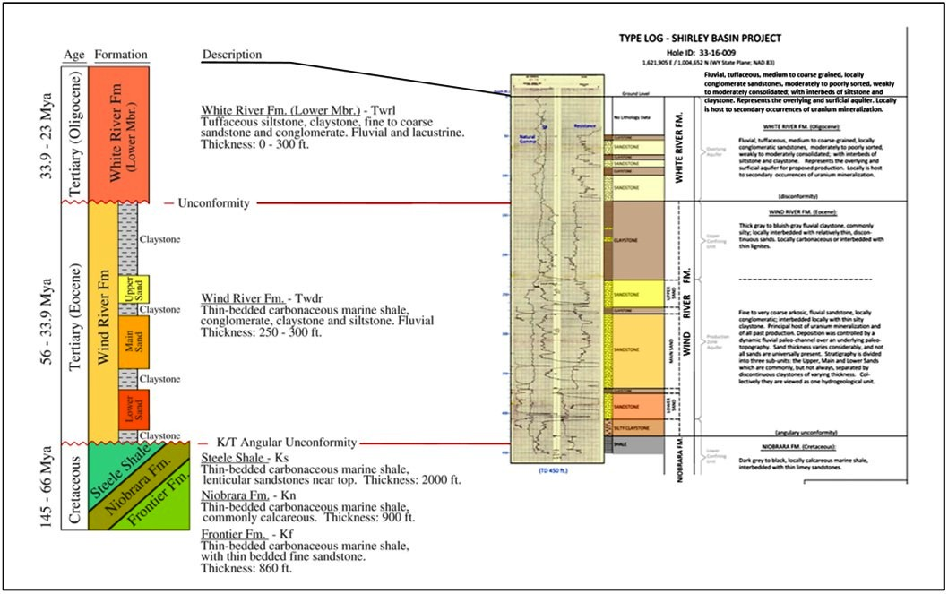
Chart shows ore bearing Wind River Formation and adjacent units (left) and a subsurface type log response (right).
Image: Left: After Covington, J.H., and Kennelly, P., 2018, Paleotopographic influences of the Cretaceous/Tertiary angular unconformity on uranium mineralization in the Shirley Basin, Wyoming: Journal of Maps, Vol. 14, Issue 2, Fig. 2, p. 591; https://www.tandfonline.com/doi/pdf/10.1080/17445647.2018.1512014?needAccess=true;
Right: After Schiffer, B.J., and Moore, R.B., 2015, Preliminary Economic Assessment Shirley Basin Uranium Project Carbon County, Wyoming, USA, Report for NI 43-101, Fig. 7, p. 30; http://www.ur-energy.com/technical-reports/.
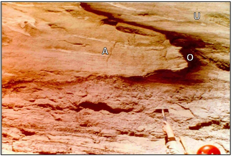
Uranium ore roll front showing contact of altered-sandstone tongue (reddish brown), unaltered sandstone (yellow-tan), and uranium ore (bark brown) on pit wall. Oxidized ore-bearing groundwater (flowing left to right) altered pyrite and iron-bearing minerals to limonite/goethite, or locally hematite in altered-sandstone. Abbreviations: A - altered sandstone, O – uranium ore, U – unaltered sandstone.
Image: After Carpenter, D., 2013, Understanding Uranium Roll-Front Ore Body Formation Aids in Predicting Mine Closure Challenges; http://www.hardhathr.com/know-your-business-series/know-your-business-part-2-roll-front-uranium-deposits/.
Image: After Carpenter, D., 2013, Understanding Uranium Roll-Front Ore Body Formation Aids in Predicting Mine Closure Challenges; http://www.hardhathr.com/know-your-business-series/know-your-business-part-2-roll-front-uranium-deposits/.
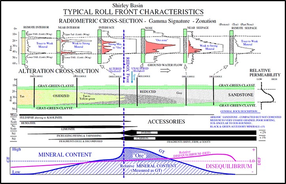
Typical roll-front model showing gamma ray log characteristic signatures with their relative position to redox boundary (boundary between oxidized and reduced rocks) and some mineral and elemental distributions along the roll-front deposit.
Image: Covington, J.H., and Kennelly, P., 2018, Paleotopographic influences of the Cretaceous/Tertiary angular unconformity on uranium mineralization in the Shirley Basin, Wyoming: Journal of Maps, Vol. 14, Issue 2, Fig. 5, p. 593; https://www.tandfonline.com/doi/pdf/10.1080/17445647.2018.1512014?needAccess=true.
Image: Covington, J.H., and Kennelly, P., 2018, Paleotopographic influences of the Cretaceous/Tertiary angular unconformity on uranium mineralization in the Shirley Basin, Wyoming: Journal of Maps, Vol. 14, Issue 2, Fig. 5, p. 593; https://www.tandfonline.com/doi/pdf/10.1080/17445647.2018.1512014?needAccess=true.
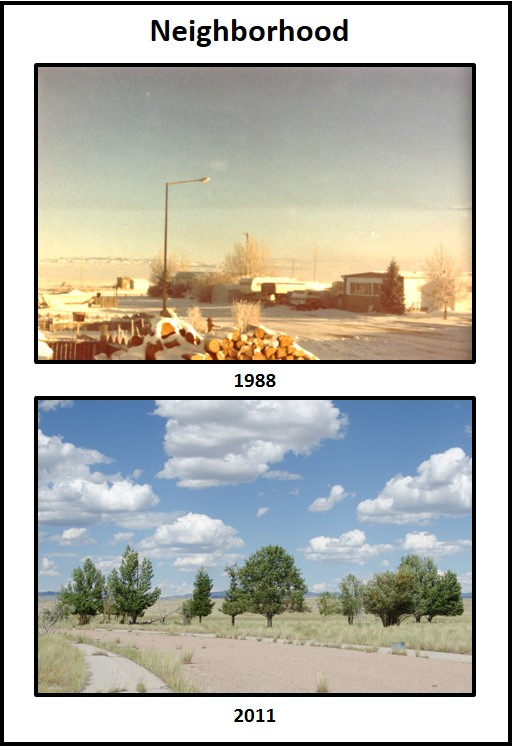
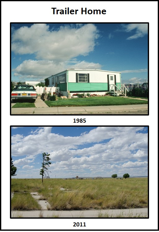
Then and now views of company-owned Shirley Basin trailer park during and after the mining boom (abandoned, 1992). The Bad Medicine Inn hosted a grocery store, post office, bank, gas station, mechanic shop, cafe, and bar. The latter facility served as the center of the community’s social life.
Image: After Heidpriem, J., 2011, Shirley Basin; https://cargocollective.com/josephineheidepriem/SHIRLEY-BASIN.
Image: After Heidpriem, J., 2011, Shirley Basin; https://cargocollective.com/josephineheidepriem/SHIRLEY-BASIN.
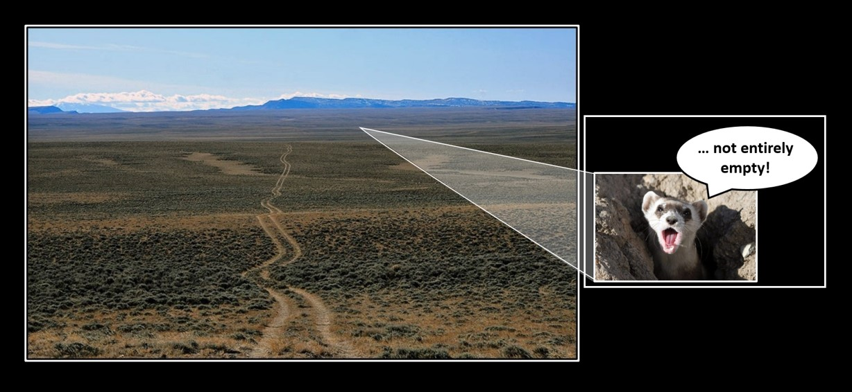
Shirley Basin uranium mining district was the second largest operation in Wyoming from 1960s to 1990s (Gas Hills District was the most productive). The basin mines were closed in 1992 due to economic factors following Three Mile Island accident (1979), not for a lack of resource. In 2015, UR-Energy proposed to reopen the mine using in-situ recovery technique. The company estimates total measured plus indicated uranium resources (0.23% average grade) to be over 1.9 million short tons of ore (8.8 million pounds of U3O8). This compares to Shirley Basin historical uranium production (1960 to 1992) of 51 million pounds of U3O8. Wyoming is the largest producer and contains the greatest uranium ore reserves in the United States. But, until mining is renewed, Shirley Basin will remain part of Wyoming’s “Big Empty.”
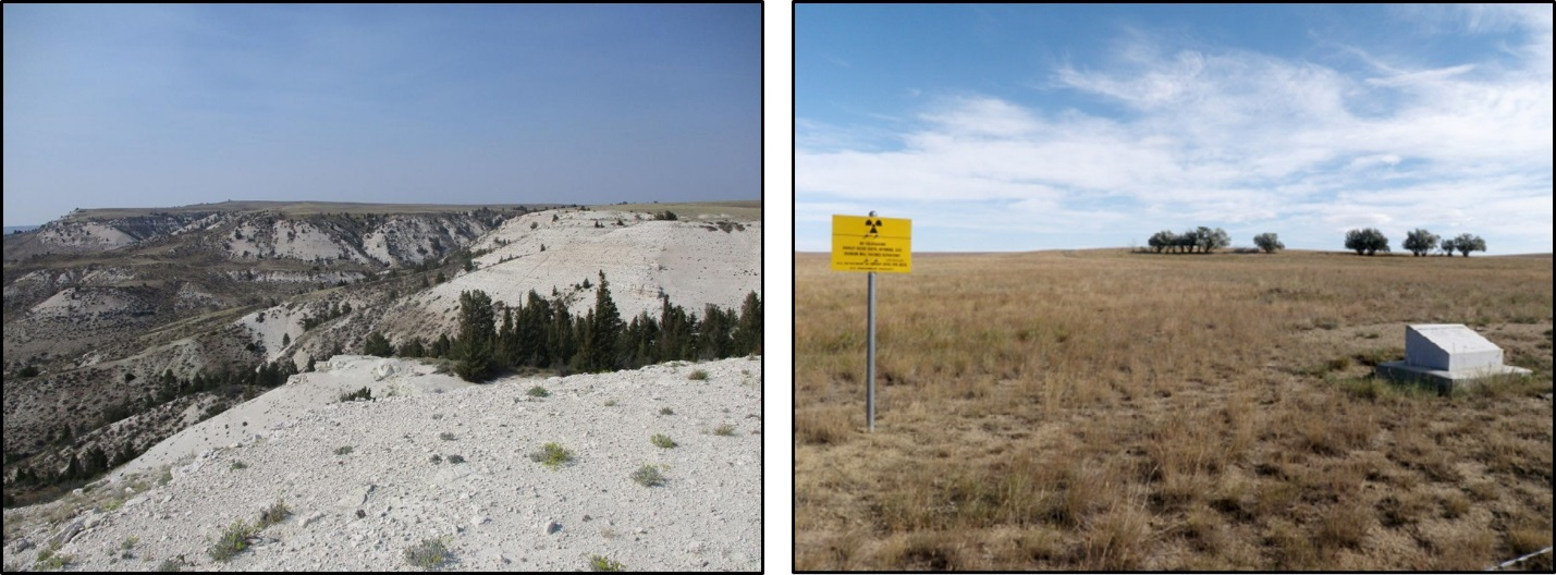
Left: Bates Hole escarpment, northern margin, Shirley Basin; Right: Reclaimed site at South Shirley Basin Uranium District.
Image: Left: Image: Travsky, A., 2019, Shirley Basin – embracing the value of empty: Wyoming Tribune Eagle; https://www.wyomingnews.com/shirley-basin-embracing-the-value-of-empty/article_fa7964b7-d195-5e0b-af72-4846af429b88.html;
Right: Wilson, A.B., 2015, Uranium in the Wyoming Landscape Conservation Initiative Study Area, Southwestern Wyoming: U.S. Geological Survey Open-File Report 2014-1123, Fig. 6B, p. 23; https://pubs.usgs.gov/of/2014/1123/pdf/ofr20141123.pdf.
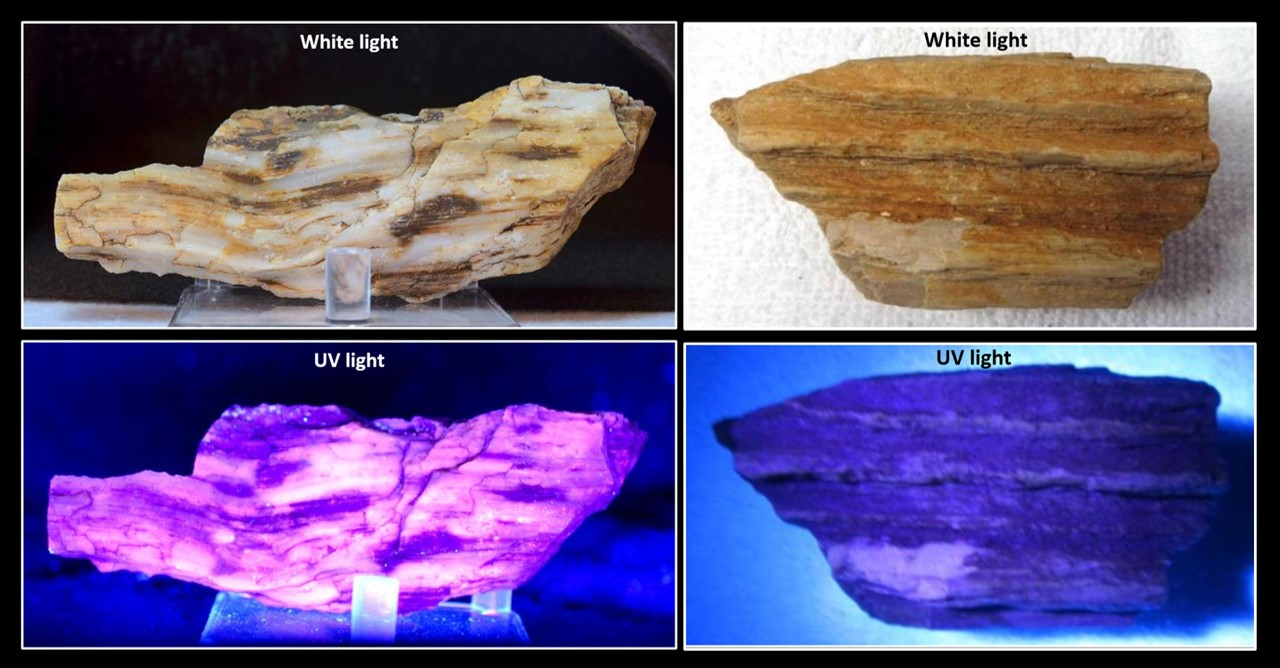
Remains of an Eocene fossil forest are in the Wind River Formation to the east of the mining district. The area was home to a swampy, humid forest 50 million years ago. Most of the logs and larger petrified specimens were removed by commercial collectors during the 1930s to 1950s. Small pieces of petrified wood can still be found in Sections 11-14, Township 27 North, Range 78 West. The specimens usually are shades of white, brown and black that sometimes show fluorescence. Twenty-five pounds of wood may be collected on BLM lands without a permit in one day. One person is limited to 250 pounds in a single year.
Shirley Basin petrified wood specimens with fluorescent and ultraviolet light.
Image: Left: Jones, P., before 2000, Jones Mineral Cabinet, on Etsy: https://www.etsy.com/listing/260055024/petrified-wood-with-nice-fluorescence;
Right: ember64, No Date, Home on the Range, on eBay; https://www.ebay.com/itm/Petrified-Wood-302g-Fluorescent-Fossil-Tree-Display-Shirley-Basin-Wyoming-/152907026127.
Shirley Basin Archaeology
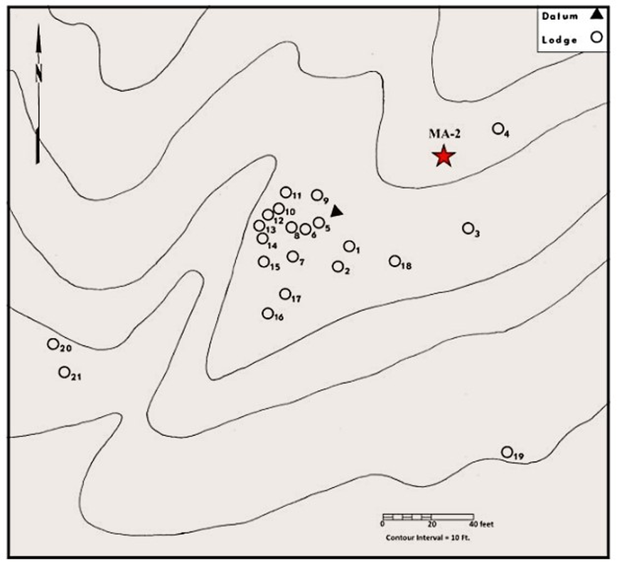
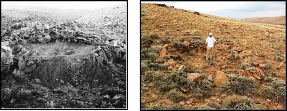
Nomadic Indians camped and hunted in the Shirley Basin. Tipi rings and remnants of stone walled structures are found on the high plateaus overlooking drainage areas (SE, NW, Section 23, Township 27 North, Range 77 West, and several miles eastward from the SW, Section 28, Township 27 North, Range 80 West, and from Section 32, Township 29 North, Range 77 West).
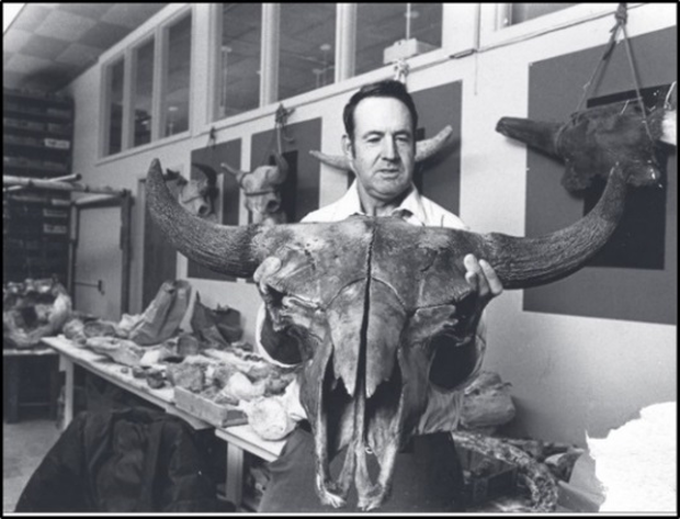
Remains of six extinct bison (Bison antiquus figgins) have been found at a kill site in the Kerr McGee open pit mine (Section 11, Township 27 North, Range 78 West). Palynologic dating of spruce, pine and fir pollen from the bison remains level indicate a post-Wisconsin glacial, Pleistocene age. A 1975 University of Wyoming Master’s thesis estimated site occupation to date between AD 1500 -1750 (Zeimens, 1975, 48AB301: A Late Prehistoric period site in the Shirley Basin of Wyoming). A 2012 excavation obtained an uncalibrated radiocarbon date of 270 +/- 30 years before present (1742 AD).
Remains of six extinct bison (Bison antiquus figgins) have been found at a kill site in the Kerr McGee open pit mine (Section 11, Township 27 North, Range 78 West). Palynologic dating of spruce, pine and fir pollen from the bison remains level indicate a post-Wisconsin glacial, Pleistocene age. A 1975 University of Wyoming Master’s thesis estimated site occupation to date between AD 1500 -1750 (Zeimens, 1975, 48AB301: A Late Prehistoric period site in the Shirley Basin of Wyoming). A 2012 excavation obtained an uncalibrated radiocarbon date of 270 +/- 30 years before present (1742 AD).
Bison antiquus: Left: Life-size restoration reference scale; Right: Skeleton from La Brea Tar Pits, Los Angeles.
Image: Left: After https://www.deviantart.com/homero13/art/Bison-antiquus-481864286;
Right: After Bierman, N., 2012, Bison antiquus; https://commons.wikimedia.org/wiki/File:Bison_antiquus.jpg.
Image: Left: After https://www.deviantart.com/homero13/art/Bison-antiquus-481864286;
Right: After Bierman, N., 2012, Bison antiquus; https://commons.wikimedia.org/wiki/File:Bison_antiquus.jpg.
George Frison holding a male Bison antiquus skull recovered during uranium mining operations in the Shirley Basin area, southeast Wyoming, 1980.
Image: Mammoth Trumpet, 2015, Volume 30, Number 2, Fig. on p. 3;
https://liberalarts.tamu.edu/wp-content/uploads/sites/14/2019/08/vol30_num2.pdf
Image: Mammoth Trumpet, 2015, Volume 30, Number 2, Fig. on p. 3;
https://liberalarts.tamu.edu/wp-content/uploads/sites/14/2019/08/vol30_num2.pdf
Generalized cross section of pit wall in Kerr McGee North Walker Uranium Mine (Section 11, Township 27 North, Range 78 West). The Eocene fossil forest location is about one-half mile east of the section 11 mine.
Image: After Fletcher, C.D., 1970, Wyoming Geological Association Earth Science Bulletin, Vol. 3, No. 1, Text, p. 5, and Fig. 9, p. 9, in Wyoming Geological Association (WGA) publications (1946-2011), 3rd edition, DVD.
Image: After Fletcher, C.D., 1970, Wyoming Geological Association Earth Science Bulletin, Vol. 3, No. 1, Text, p. 5, and Fig. 9, p. 9, in Wyoming Geological Association (WGA) publications (1946-2011), 3rd edition, DVD.
The original 1969 excavation map showing the location of the stacked stone dwellings and the new structure, MA-2, discovered in 2012.
Image: Schroeder, B., 2017, SPECIAL FEATURE: Shirley Basin Lodge Site: The Calumet, Colorado Archaeological Society, Fig. 4, p. 10; http://www.indianpeaksarchaeology.org/wp-content/uploads/2017/07/Calumet_Mar-2017.pdf.
Image: Schroeder, B., 2017, SPECIAL FEATURE: Shirley Basin Lodge Site: The Calumet, Colorado Archaeological Society, Fig. 4, p. 10; http://www.indianpeaksarchaeology.org/wp-content/uploads/2017/07/Calumet_Mar-2017.pdf.
House Site #5 at the end of the 1969 excavation (Left); Bryon Schroeder (2012 excavation) stands in a structure first excavated 45 years ago in the Shirley Basin (Right).
Image: Left: Schroeder, B., 2017, SPECIAL FEATURE: Shirley Basin Lodge Site: The Calumet, Colorado Archaeological Society, Fig. 2, p. 9; http://www.indianpeaksarchaeology.org/wp-content/uploads/2017/07/Calumet_Mar-2017.pdf;
Right: Dayton, K., 2015, Ancient town yields new clues to early life in Wyoming: WyoFile; https://www.wyofile.com/ancient-town-yields-new-clues-early-life-wyoming/.
Shirley Basin Black-Footed Ferrets
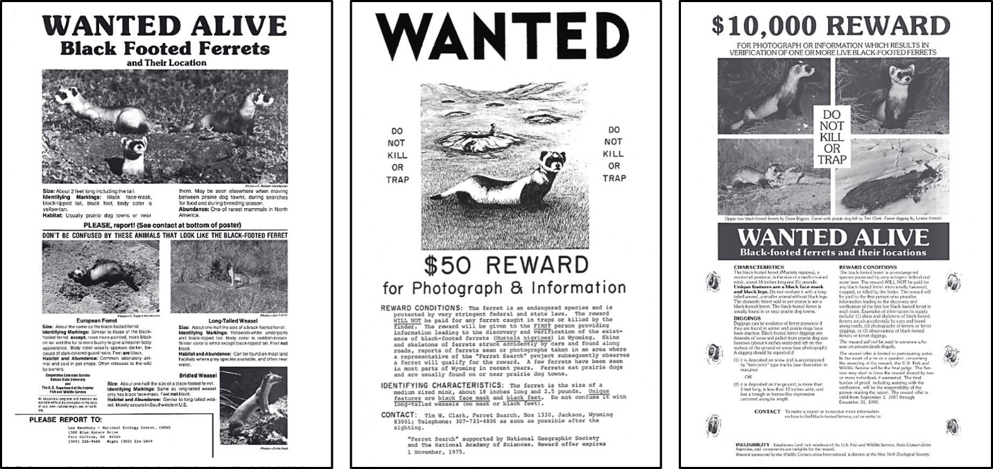
The black-footed ferret (Mustela nigripes) was listed as an endangered species with the passage of the Endangered Species Act in 1973. Ferret extinction was declared in 1979 because no ferret had been seen in the wild throughout the 1970s. Several states offered rewards for sighting and location of a black-footed ferret. Reward posters were found in post offices, public buildings, and businesses. In 1981, the Hogg ranch’s dog (Shep) brought a black-footed ferret carcass to their porch near Meeteetse. A “business” (group of ferrets) was discovered in a white-tailed prairie dog town on the nearby Pitchfork Ranch. Coincidentally at the turn of the century, the Pitchfork Ranch was also home to one of the last free-roaming bison herds in North America.
Black-footed ferret wanted posters, 1974-1989.
Image: Hanebury, L.R. and Biggins, D.E., 2006, A History of Searches for Black-footed Ferrets, Appendix, p. 59, 60, 65, in Roelle, J.E., Miller, B.J., Godbey, J.L., and Biggins, D.E., eds., 2006, Recovery of the black-footed ferret—progress and continuing challenges: U.S. Geological Survey Scientific Investigations Report 2005–5293; https://pubs.usgs.gov/sir/2005/5293/report.pdf.
Image: Hanebury, L.R. and Biggins, D.E., 2006, A History of Searches for Black-footed Ferrets, Appendix, p. 59, 60, 65, in Roelle, J.E., Miller, B.J., Godbey, J.L., and Biggins, D.E., eds., 2006, Recovery of the black-footed ferret—progress and continuing challenges: U.S. Geological Survey Scientific Investigations Report 2005–5293; https://pubs.usgs.gov/sir/2005/5293/report.pdf.
A captive breeding program began in 1985 due to canine distemper and Sylvatic plague outbreaks in the prairie dog and ferret populations in the Meeteetse area. The last eighteen surviving ferrets were captured for the recovery project. Ferrets were first reintroduced to the wild in the Shirley Basin (Location 1). Today there are thirty release sites in western North America from Canada to Mexico. All the ferrets alive today are direct descendants of the eighteen trapped ferrets near Meeteetse. In 2016, ferrets returned to the Meeteetse area (Location 28 on map below).
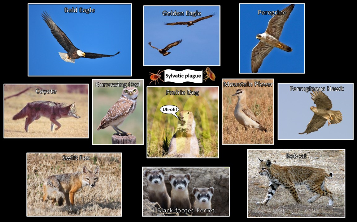
The prairie dog makes up 90-95 percent of the black-footed ferret diet (“Shirley Basin McNuggets”). Other Shirley Basin prairie dog predators are shown. The insects (tick and flea) carry the bacterium Yersinia pestis which causes Sylvatic plague (called the black plague in humans) which decimated prairie dog and ferret populations. The rodents have also been infected with the canine distemper virus.
Image: Bald Eagle: https://www.flickr.com/photos/usfwsmtnprairie/23694296804/in/photostream/; Golden Eagle: https://www.instagram.com/p/B1l2aeFHGn2/?igshid=k9ocd0ofws7z; Peregrine: https://blogs.plos.org/everyone/2014/03/01/falcon-physics-science-diving-peregrine-falcons/; Coyote: https://evanstonroundtable.com/main.asp?SectionID=15&ArticleID=15670; Burrowing Owl: https://cheyennebirdbanter.wordpress.com/category/burrowing-owl/; Prairie Dog: After https://defenders.org/wildlife/prairie-dog; Mountain Plover: https://wgfd.wyo.gov/WGFD/media/content/PDF/Habitat/SWAP/Birds/Mountain-Plover.pdf; Swift Fox: https://trib.com/outdoors/populations-of-swift-foxes-booming-in-wyoming-growing-in-montana/article_8c15db9b-e56a-558b-a2d7-7a42c65fe1d0.html; Black-footed ferret: https://www.wyomingpublicmedia.org/post/black-footed-ferrets-making-comeback#stream/0; Bobcat: https://en.wikipedia.org/wiki/Bobcat#/media/File:Calero_Creek_Trail_Bobcat.jpg.
Image: Bald Eagle: https://www.flickr.com/photos/usfwsmtnprairie/23694296804/in/photostream/; Golden Eagle: https://www.instagram.com/p/B1l2aeFHGn2/?igshid=k9ocd0ofws7z; Peregrine: https://blogs.plos.org/everyone/2014/03/01/falcon-physics-science-diving-peregrine-falcons/; Coyote: https://evanstonroundtable.com/main.asp?SectionID=15&ArticleID=15670; Burrowing Owl: https://cheyennebirdbanter.wordpress.com/category/burrowing-owl/; Prairie Dog: After https://defenders.org/wildlife/prairie-dog; Mountain Plover: https://wgfd.wyo.gov/WGFD/media/content/PDF/Habitat/SWAP/Birds/Mountain-Plover.pdf; Swift Fox: https://trib.com/outdoors/populations-of-swift-foxes-booming-in-wyoming-growing-in-montana/article_8c15db9b-e56a-558b-a2d7-7a42c65fe1d0.html; Black-footed ferret: https://www.wyomingpublicmedia.org/post/black-footed-ferrets-making-comeback#stream/0; Bobcat: https://en.wikipedia.org/wiki/Bobcat#/media/File:Calero_Creek_Trail_Bobcat.jpg.
Left: Black-footed ferret reintroduction site locations and initial release year in the Rocky Mountains/Great Plains area. The prairie dog distribution shows the historic habitat of the Black-footed ferret; Right: Black-footed Ferret
Image: Left: After South Dakota Game, Fish & Parks, 2018, Black-footed Ferret Presentation, Slide 10/40; https://gfp.sd.gov/UserDocs/meetings/Black-footed_ferret.pdf.
Right: VanOstrand, M., 2016, KOTA TV; Black-Footed Ferrets released at Wind Cave National Park
Image: Left: After South Dakota Game, Fish & Parks, 2018, Black-footed Ferret Presentation, Slide 10/40; https://gfp.sd.gov/UserDocs/meetings/Black-footed_ferret.pdf.
Right: VanOstrand, M., 2016, KOTA TV; Black-Footed Ferrets released at Wind Cave National Park
Shirley Basin Wind Farm
Eighteen miles south of abandoned Shirley Basin townsite is PacifiCorp’s Dunlap Wind Farm. The project site is eight miles north of Medicine Bow, at the southeast foot of the Freezeout Mountains. The wind farm lies within the Wyoming wind corridor that extends from Rawlins to Wheatland (See https://www.geowyo.com/big-hollow.html). The Project was operational in September 2001 with 74, 1.5-megawatt turbines generating 111 megawatts of electricity.
Top: Wyoming wind corridor with location of Shirley Basin townsite (green dot) and Dunlap Wind Farm (yellow star); Bottom: Dunlap Wind Farm location and facilities on land ownership map. Location of wind farm photo from WY-487 on Flattop Mountain is shown at bottom of map.
Image: Top: After Marwitz J.D., Dawson P.J. (1986) Low Level Airflow in Southern Wyoming during Wintertime by Aircraft. In: Xu Y. (eds) Proceedings of International Symposium on the Qinghai-Xizang Plateau and Mountain Meteorology. American Meteorological Society, Boston, MA, Fig. 1, p.478; Bottom: After CH2MHILL, 2009, Final Report Wyoming Industrial Development Information and Siting Act Section 109 Permit Application, Dunlap Energy Project, Prepared for PacifiCorp Energy, Appendix A, Fig. A-1, A-2; http://deq.wyoming.gov/media/attachments/Industrial%20Siting/Application%20and%20Permits/Dunlap%20Wind%20Energy%20Project/2009-0617_ISD_Application-for-Permit_Pacificorp-Energy_Dunlap-Wind-Energy_09-01.pdf.
Image: Top: After Marwitz J.D., Dawson P.J. (1986) Low Level Airflow in Southern Wyoming during Wintertime by Aircraft. In: Xu Y. (eds) Proceedings of International Symposium on the Qinghai-Xizang Plateau and Mountain Meteorology. American Meteorological Society, Boston, MA, Fig. 1, p.478; Bottom: After CH2MHILL, 2009, Final Report Wyoming Industrial Development Information and Siting Act Section 109 Permit Application, Dunlap Energy Project, Prepared for PacifiCorp Energy, Appendix A, Fig. A-1, A-2; http://deq.wyoming.gov/media/attachments/Industrial%20Siting/Application%20and%20Permits/Dunlap%20Wind%20Energy%20Project/2009-0617_ISD_Application-for-Permit_Pacificorp-Energy_Dunlap-Wind-Energy_09-01.pdf.
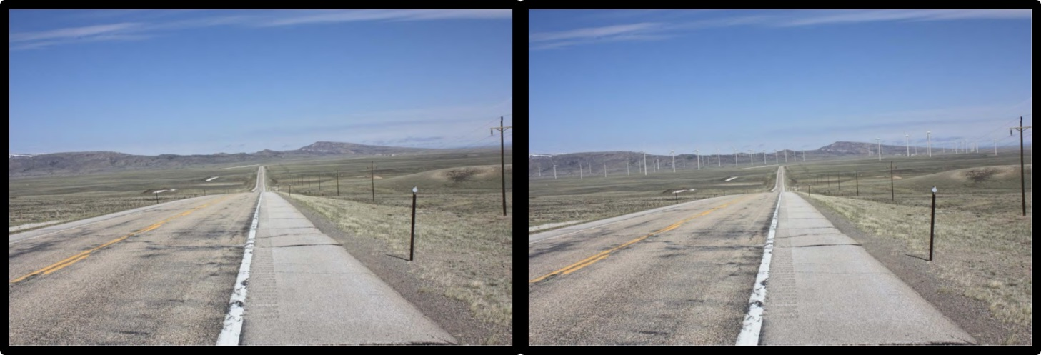
Before and after northbound images of Dunlap Wind Farm, Shirley Basin from WY-487 on Flattop Mountain.
Image: After CH2MHILL, 2009, Final Report Wyoming Industrial Development Information and Siting Act Section 109 Permit Application, Dunlap Energy Project, Prepared for PacifiCorp Energy, Appendix F, Fig. F-11, F-12; http://deq.wyoming.gov/media/attachments/Industrial%20Siting/Application%20and%20Permits/Dunlap%20Wind%20Energy%20Project/2009-0617_ISD_Application-for-Permit_Pacificorp-Energy_Dunlap-Wind-Energy_09-01.pdf
Image: After CH2MHILL, 2009, Final Report Wyoming Industrial Development Information and Siting Act Section 109 Permit Application, Dunlap Energy Project, Prepared for PacifiCorp Energy, Appendix F, Fig. F-11, F-12; http://deq.wyoming.gov/media/attachments/Industrial%20Siting/Application%20and%20Permits/Dunlap%20Wind%20Energy%20Project/2009-0617_ISD_Application-for-Permit_Pacificorp-Energy_Dunlap-Wind-Energy_09-01.pdf
The “Big Empty,” Shirley Basin.
Image: Koelling, R., 2009, (Mostly) Wyoming Photos Blog; http://wyophotos.blogspot.com/2009/11/shirley-basin.html; Buckrail, 2017, Wyoming Game and Fish Department photo; https://buckrail.com/feisty-ferrets-make-worldwide-recovery-in-meeteetse/.
Image: Koelling, R., 2009, (Mostly) Wyoming Photos Blog; http://wyophotos.blogspot.com/2009/11/shirley-basin.html; Buckrail, 2017, Wyoming Game and Fish Department photo; https://buckrail.com/feisty-ferrets-make-worldwide-recovery-in-meeteetse/.

The material on this page is copyrighted


