Adobe Town
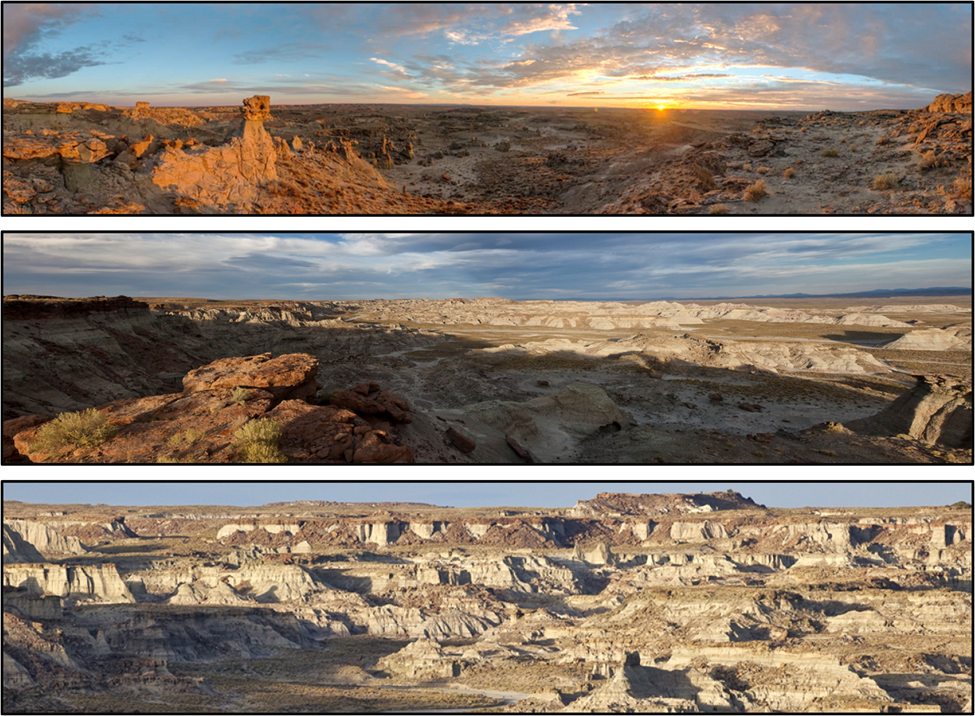
Image: Top: Copland, S. 2017, WyoFile; https://www.wyofile.com/discover-red-desert-2017/;
Middle: https://www.flickr.com/photos/mypubliclands/8749786457/in/photolist-ekhG9o-ekbW4i-ekhJmW-ekbWRe-ekbWvD-ekhFjU-ekhFaW-ekbWdn-ekbVPV-ekhHhL-ekhGxu-ekbV5K-ekhGhd-ekhFu9-ekhJ4s-wxc3Q3-ekhErq-ekhFp7-akPB8U-xetLtJ-ekbWFc/;
Bottom: After Programs: National Conservation Lands: Wyoming: Adobe Town WSA | Bureau of Land Management (blm.gov).
Wow Factor (3 out of 5 stars):
Geologist Factor (3 out of 5 stars):
Attraction
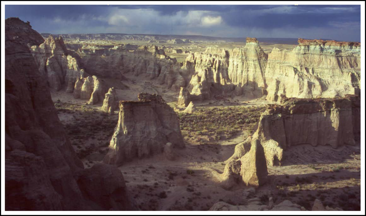
Isolated in the western Washakie Basin lies Adobe Town. The residents of the town’s earthen structure walls, towers, ridges, and canyons are not people. Wild horses, pronghorn, coyotes, elk, raptors, and assorted burrowing critters comprise the population in this breathtaking badlands wilderness.
The Washakie Basin is located in the southeastern corner of the Greater Green River Basin. It is a square-shaped, rimmed basin about 50 miles across. The DeLaney (north) and Kinney (west) Rims rise about 1,000 feet above the basin floor. The basin is the southern part of the Red Desert, Wyoming. The high elevation (6,600 to 7,800 feet) badlands of Adobe Town are the central feature of the area.
Adobe Town Wilderness Study Area
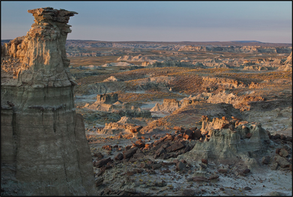
Image: Wick, B., 2010, https://www.flickr.com/photos/mypubliclands/8750908246
Image: Wick, B., 2010, https://www.flickr.com/photos/mypubliclands/8750908246
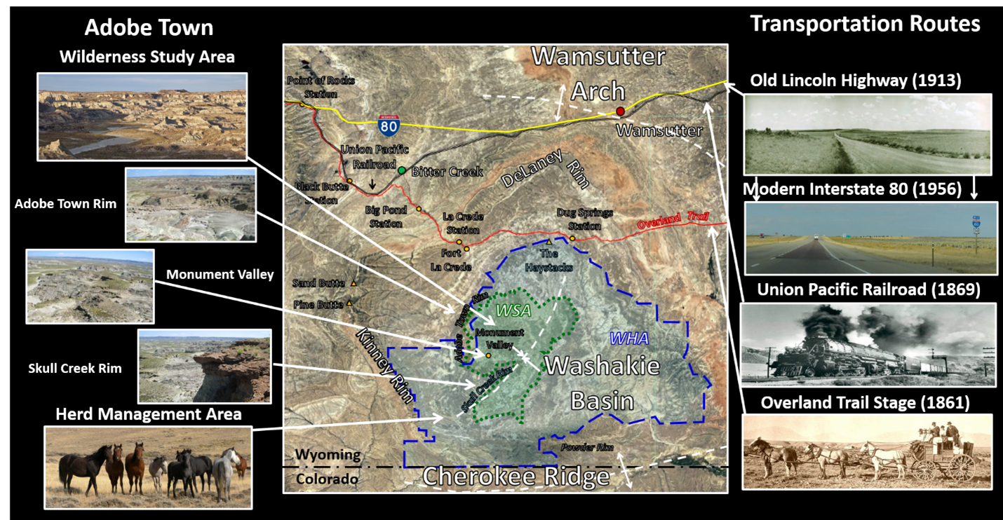
Washakie Basin showing Adobe Town Wilderness Study Area (WSA) in green and Herd Management Area (HMA) in blue.
Image: Base: Google Earth,
Lincoln Highway: Wyoming State Historic Preservation Office, Auto Landscapes and Tourism 1913 to 1975; https://wyoshpo.wyo.gov/index.php;
I-80: ;
UPRR: https://www.facebook.com/Union-Pacific-Big-Boy-Locomotive-104984082869998/;
Overland Trail: https://www.legendsofamerica.com/we-overlandstage;
Wilderness Study Area: https://www.blm.gov/programs/national-conservation-lands/wyoming/adobe-town-wsa;
Adobe Rim: https://www.summitpost.org/adobe-town-adobe-creek-rim/661445/c-663143;
Monument Valley: https://www.summitpost.org/adobe-town-adobe-creek-rim/661457;
Skull Creek Rim: https://www.summitpost.org/adobe-town-skull-creek-rim/658939/c-663143;
Herd Management Area: https://www.blm.gov/programs/wild-horse-and-burro/herd-management/herd-management-areas/wyoming/adobe-town.
Adobe Town History
The Washakie Basin contains archeologic evidence of human occupation for up to 12,000 years, but Native American paths and historic trails generally avoided the central Adobe Town badlands area.
Where deserts lay, men stayed away. (Bartlett, R.A., 1956, Clarence King's Fortieth Parallel Survey: Utah Historical Quarterly, Vol. 24, p. 147.)
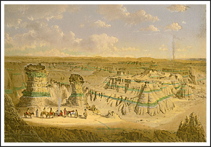
In 1869, the 40th Parallel Survey (1867-7-1872) led by Clarence King (Chief of Geologists) and General A.A. Humphrey (Chief of Engineers) traveled through the central badlands region and provide the first report of the Adobe Town landscape:
This escarpment is the most remarkable example of the so-called bad-land erosion within the limits of the Fortieth Parallel Exploration. The Bridger beds here rise about 300 feet above the level, dry valley to the south, and present a series of abrupt, nearly vertical faces, worn into innumerable architectural forms, outliers often standing detached from the main wall in bold blocks, which have been wrought into a variety of singular forms by eolian erosion. Plate XV. gives a very fair general view of a portion of the Bad Lands, showing some of the curious buttressed shapes. A few ravines cut their way through the plateau from considerable distances back in the basin. Along the walls of these ravines the same picturesque architectural forms occur, so that a view of the whole front of the escarpment, with its salient and reentrant angles, reminds one of the ruins of a fortified city. Enormous masses project from the main wall, the stratification-lines of creamy, gray, and green sands and marls are traced across their nearly vertical fronts like courses of immense masonry, and every face is scored by innumerable narrow, sharp cuts, which are worn into the soft material from top to bottom of the cliff, offering narrow galleries which give access for a considerable distance into this labyrinth of natural fortress.
Chromolithograph Washakie Bad-Lands - Wyoming
(King, C., 1869, Report of the Geological Exploration of the Fortieth Parallel, Plate XV & text, p. 396-398; https://pubs.usgs.gov/unnumbered/70038097/report.pdf)
(King, C., 1869, Report of the Geological Exploration of the Fortieth Parallel, Plate XV & text, p. 396-398; https://pubs.usgs.gov/unnumbered/70038097/report.pdf)
Adobe Town Rim.
Image: Molvar, E., 2015; http://pdf.wildearthguardians.org/site/DocServer/AdobeTown.pdf.
Image: Molvar, E., 2015; http://pdf.wildearthguardians.org/site/DocServer/AdobeTown.pdf.
The landscape’s erosional features resemble a village or fortress of adobe buildings. The name was first used by vertebrate paleontologist Walter Granger in 1909:
The bad lands at this part of the rim are known, because of their peculiar form of weathering, as "Adobe Town." (Granger, W., 1909, American Museum of Natural History Bulletin, Vol. 26, Article III, p. 17; Faunal horizons of the Washakie Formation of southern Wyoming. Bulletin of the AMNH; v. 26, article 3).
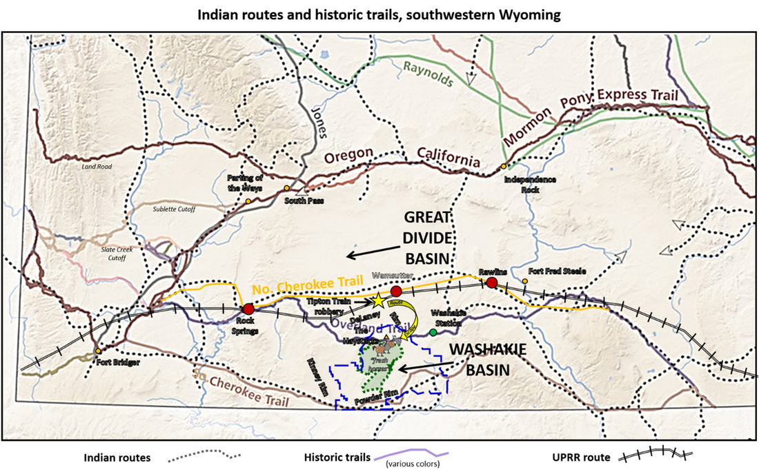
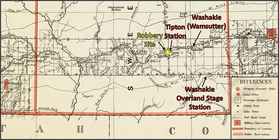
The Overland Stage-Emigrant Trail and the north and south branches of the Cherokee Trail divert around the central badlands of Adobe Town. The Union Pacific’s transcontinental railroad closely followed the Northern Cherokee Trail between the Great Divide and Washakie basins. The town of Wamsutter (1868) was originally named Washakie, but due to confusion in delivery of mail and freight with Fort Washakie, Fremont County the name was changed in 1885. Wamsutter is the only town that lies within the Red Desert and is called “The Gateway to the Red Desert.” The name Washakie was also used for a stage stop on the Overland Trail, located about 20 miles southeast of Wamsutter.
Map of Indian and emigrant routes, southern Wyoming with approximate route of the Transcontinental Railroad shown (black tracks). Notice the routes avoid the badlands area. Adobe Town Wilderness Study Area in green and Herd Management Area in blue.
Image: After https://www.wyohistory.org/sites/default/files/geography1New_0.jpg.
Image: After https://www.wyohistory.org/sites/default/files/geography1New_0.jpg.
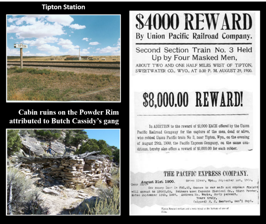
On the evening of August 29, 1900, Butch Cassidy and the Wild Bunch robbed a west-bound Union Pacific train two and a half miles west of Tipton Station. The gang employed the same technique it had used in the Wilcox robbery committed the year before. They made their escape eastward around the Haystacks where they had hidden fresh horses.
Portion of the 1879 Territory of Wyoming map. Note: map date is before name change of Washakie Station in 1885.
Image: After David Rumsey Historical Map Collection; Territory Of Wyoming. - David Rumsey Historical Map Collection.
Image: After David Rumsey Historical Map Collection; Territory Of Wyoming. - David Rumsey Historical Map Collection.
Butch Cassidy’s gang train robbery near Tipton Station.
Image: Station & reward poster: https://www.facebook.com/media/set/?set=a.355415244561870.1073741839.288887801214615&type=3; Cabin: Blewer, M., photo in Molvar, E., 2015, Adobe Town: Briefing Book, p. 4; ATBriefingBook2015 p 1 thru 2 (wildearthguardians.org).
Image: Station & reward poster: https://www.facebook.com/media/set/?set=a.355415244561870.1073741839.288887801214615&type=3; Cabin: Blewer, M., photo in Molvar, E., 2015, Adobe Town: Briefing Book, p. 4; ATBriefingBook2015 p 1 thru 2 (wildearthguardians.org).
Adobe Town Geology
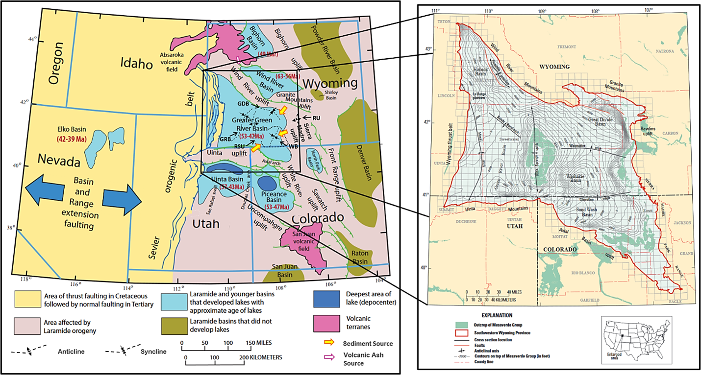
The onset of the latest Cretaceous Laramide tectonism created the Washakie Basin and surrounding arches shown on the tectonic and geologic maps. Throughout the early Tertiary, the basin oscillated between a marshy, flood plain to large lake depositional environments. The river-lake stratigraphy of Eocene Wasatch Formation (55.8-46.2 million years ago) and the Green River Formation (53.5-48.5 million years ago) records their complex interfingering. Ash from the Absaroka and Challis volcanic fields rained down on both formations settling in the Green River Lake bottom and reworked by the Wasatch streams. Alteration of the tuff beds produced the zeolite deposits found along Kinney Rim.
Left: Geology map of the central Rocky Mountain region showing area affected by the Laramide orogeny (pale pink), volcanic terranes (dark pink) and later Basin and Range extension (yellow). Laramide structural and sedimentary basins are blue if they include significant lacustrine intervals and olive green if they do not. Approximate ages of lacustrine intervals in each basin shown in red text. Major faults are shown as green lines with arrows on upthrown sides if specified by King (1969) as thrust faults. Abbreviations: GDB = Great Divide Basin; GRB = Green River Basin; RSU = Rock Springs Uplift; RU Rawlins Uplift; WB = Washakie Basin.
Right:Top of Mesaverde Formation structure map of the Greater Green River Basin, southwestern Wyoming, and adjacent areas, showing major basinal areas and adjoining uplifts.
Image: Left: After Johnson, R.C., Birdwell, J.E., Lillis, P.G., 2017, Stratigraphic Intervals for Oil and Tar Sand Deposits in the Uinta Basin, Utah: The Mountain Geologist, Vol. 54, No. 4, Fig. 1, p. 229.
Right: Self, J.G., Ryder, R.T., Johnson, R.C., Brownfield, and M.E., Mercier, T.J., 2011, Stratigraphic cross sections of the Eocene Green River Formation in the Green River Basin, southwestern Wyoming, northwestern Colorado, and north-eastern Utah, in U.S. Geological Survey Oil Shale Assessment Team, ed., Oil shale resources of the Eocene Green River Formation, Greater Green River Basin, Wyoming, Colorado, and Utah: U.S. Geological Survey Digital Data Series DDS–69–DD, chap. 5, Fig. 1, p.2; https://pubs.usgs.gov/dds/dds-069/dds-069-dd/REPORTS/69_DD_CH_5.pdf.
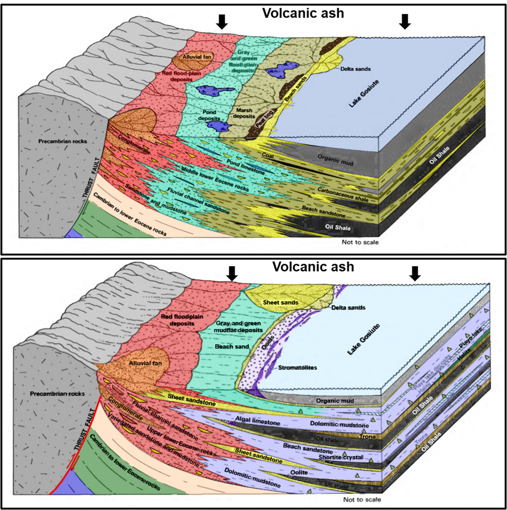
Green River Basin geologic models of Eocene depositional environments.
Top: fluvial and freshwater lake deposition.
Bottom: saltwater lake, evaporite, mudflat, playa lake, and associated fluvial depositional environments. Shortite is a sodium-calcium carbonate mineral associated with trona ore deposits. Trona is a non-marine evaporite that is the main source of soda ash or bicarbonate of soda used in manufacturing of glass, soaps, and paper.
Image: After Roehler, H.W., 1993, Eocene climates, depositional environments, and geography, Greater Green River Basin, Wyoming, Utah, and Colorado: U.S. Geological Survey Professional Paper 1506-F, Fig. 25, p. 26 and Fig. 30, p. 29;
https://pubs.usgs.gov/pp/1506f/report.pdf
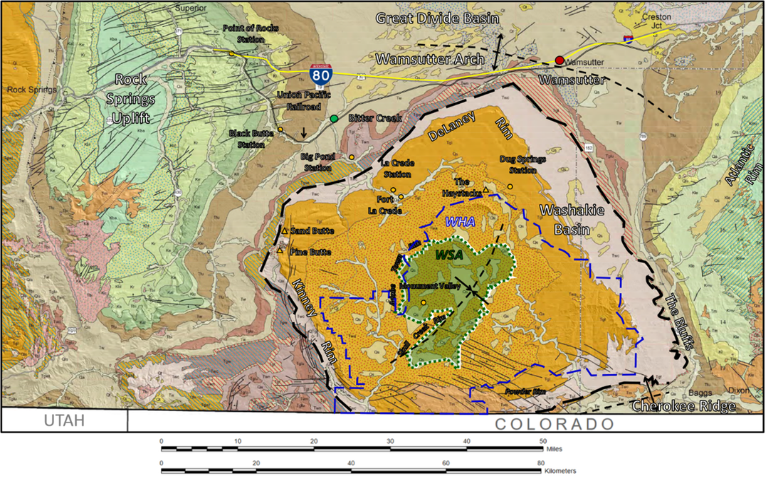
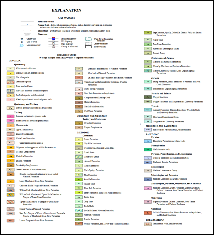
Geologic map of Washakie Basin area. Approximate limit of Cathedral Bluffs Tongue of Wasatch Formation shown by black long dash line. Adobe Town Wilderness Study Area (green) and Herd Management Area (blue dash line) are also displayed.
Image: After Lyons, W. and Ranz, P. A., No Date, Digital cartography and layout Greater Green River Basin, Wyoming (Geology modified from Love and Christianson, 1985), Wyoming State Geological Survey;
https://www.wsgs.wyo.gov/docs/wsgs-web-ggrb-geologic-map.pdf.
Image: After Lyons, W. and Ranz, P. A., No Date, Digital cartography and layout Greater Green River Basin, Wyoming (Geology modified from Love and Christianson, 1985), Wyoming State Geological Survey;
https://www.wsgs.wyo.gov/docs/wsgs-web-ggrb-geologic-map.pdf.
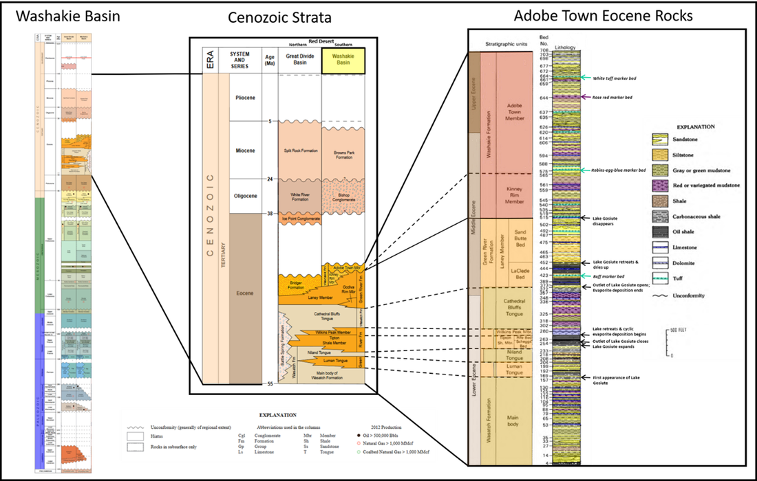
The Washakie Basin contains more than 32,000 feet of sedimentary rocks that range in age from Cambrian to Recent. Surface exposures within the basin are limited to Eocene rocks and Quaternary fluvial and dune sands. Older Mesozoic and Paleozoic units are present in the subsurface and surround the basin at the Rock Springs Uplift (west), Rawlins Uplift (northeast), and Atlantic Rim (southeast). Total thickness of Eocene rocks is 7,939 feet (Wasatch Formation 2,847 feet; Green River Formation 1,915 feet; Washakie Formation 3,177 feet). Water, wind, and gravity continue to sculpt the high desert landscape at about one inch per year. The basin’s climate and depositional stratigraphy are the controlling factors in the rate of weathering and erosion.
Stratigraphy of Washakie Basin with detail of Cenozoic strata and Eocene lithologies within Adobe Basin.
Image: Washakie Basin: After https://www.wsgs.wyo.gov/docs/wsgs-web-basin-stratigraphy.pdf; Cenozoic Strata: After Gregory, R.W., Carnes, J.D., and Bagdonas, D.A., 2016, Zeolite resources in Wyoming: Wyoming State Geological Survey Report of Investigations 72, Fig. 12, p. 12; https://www.wsgs.wyo.gov/products/wsgs-2016-ri-72.pdf; Eocene Rocks: After Roehler, H.W., 1992, Description and correlation of Eocene rocks in stratigraphic reference sections for the Green River and Washakie basins, Southwest Wyoming: includes analyses of Eocene rocks in the Washakie Basin: U.S. Geological Survey Professional Paper 1506-D, Fig. 20, p. 26; https://pubs.usgs.gov/pp/1506d/report.pdf.
Image: Washakie Basin: After https://www.wsgs.wyo.gov/docs/wsgs-web-basin-stratigraphy.pdf; Cenozoic Strata: After Gregory, R.W., Carnes, J.D., and Bagdonas, D.A., 2016, Zeolite resources in Wyoming: Wyoming State Geological Survey Report of Investigations 72, Fig. 12, p. 12; https://www.wsgs.wyo.gov/products/wsgs-2016-ri-72.pdf; Eocene Rocks: After Roehler, H.W., 1992, Description and correlation of Eocene rocks in stratigraphic reference sections for the Green River and Washakie basins, Southwest Wyoming: includes analyses of Eocene rocks in the Washakie Basin: U.S. Geological Survey Professional Paper 1506-D, Fig. 20, p. 26; https://pubs.usgs.gov/pp/1506d/report.pdf.
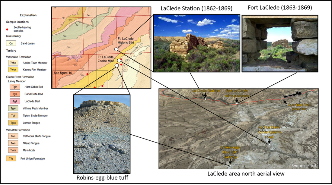
Geology, outcrop, and ruins in Fort LaClede area. Red squares on map are townships. The inactive Fort LaClede Zeolite Mine is located in Section 1, T16N R98W.
Image: Map, Explanation & Outcrop: After Gregory, R.W., Carnes, J.D., and Bagdonas, D.A., 2016, Zeolite resources in Wyoming: Wyoming State Geological Survey Report of Investigations 72, Fig. 13, p. 14, & Fig. 19, p. 19; https://www.wsgs.wyo.gov/products/wsgs-2016-ri-72.pdf; Fort: Larson, E., 2001, Fort LaClede Stage Station- Last updated 06/14/01 (over-land.com); Aerial; Google Earth; Stagecoach: http://clipart-library.com/stagecoach-cliparts.html.
Image: Map, Explanation & Outcrop: After Gregory, R.W., Carnes, J.D., and Bagdonas, D.A., 2016, Zeolite resources in Wyoming: Wyoming State Geological Survey Report of Investigations 72, Fig. 13, p. 14, & Fig. 19, p. 19; https://www.wsgs.wyo.gov/products/wsgs-2016-ri-72.pdf; Fort: Larson, E., 2001, Fort LaClede Stage Station- Last updated 06/14/01 (over-land.com); Aerial; Google Earth; Stagecoach: http://clipart-library.com/stagecoach-cliparts.html.
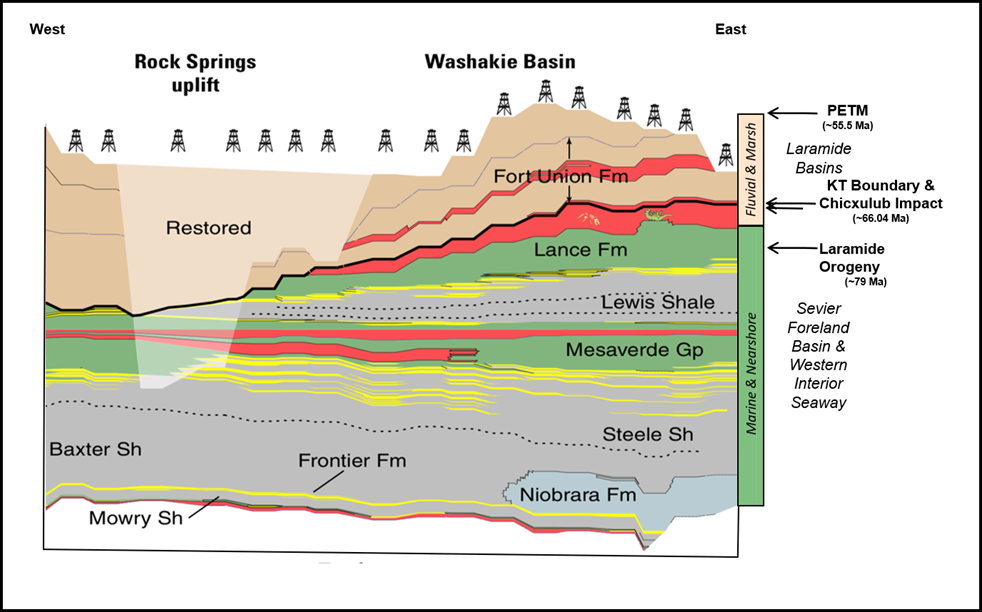
The late Cretaceous in Wyoming was characterized by the Western Interior Seaway that flooded the foreland basin east of thin-skinned uplifts created by Sevier tectonism. The onset of Laramide structuring began about 79 million years ago (Ma) during latest Cretaceous Lance Formation deposition. The Chicxulub Impact, Deccan volcanism, mass extinctions, and the PETM climate crisis all occurred near the KT boundary and in the early Tertiary.
Cretaceous and Tertiary stratigraphic cross section across the Washakie Basin.
Image: After Biewick, L.R.H., 2016, Oil and Gas Development in Southwestern Wyoming—Energy Data and Services for the Wyoming Landscape Conservation Initiative (WLCI) in U.S. Geological Survey DDS 69-D, Chapter 2, Fig. 19, p. 19: https://pubs.usgs.gov/dds/dds-069/dds-069-d/REPORTS/69_D_CH_2.pdf.
Image: After Biewick, L.R.H., 2016, Oil and Gas Development in Southwestern Wyoming—Energy Data and Services for the Wyoming Landscape Conservation Initiative (WLCI) in U.S. Geological Survey DDS 69-D, Chapter 2, Fig. 19, p. 19: https://pubs.usgs.gov/dds/dds-069/dds-069-d/REPORTS/69_D_CH_2.pdf.
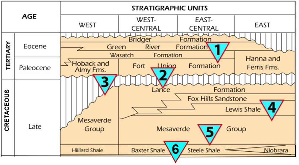
Hydrocarbons are actively produced on the margins of Adobe Town Wilderness Study Area from reservoirs in six petroleum systems:
TPS1. Wasatch–Green River Composite (Not quantitatively assessed)
TPS2. Lance–Fort Union Composite (8.7 TCFG total undiscovered resources in Southwestern Wyoming Province)
TPS3. Mesaverde–Lance–Fort Union Composite (13.7 TCFG total undiscovered resources in Southwestern Wyoming Province)
TPS4. Lewis (13.5 TCFG total undiscovered resources in Southwestern Wyoming Province)
TPS5. Mesaverde (25.8 TCFG total undiscovered resources in Southwestern Wyoming Province)
TPS6. Hilliard–Baxter-Mancos (11.7 TCFG total undiscovered resources in Southwestern Wyoming Province)
Cretaceous and Tertiary oil and gas reservoirs in the Greater Green River Basin. Numbered triangles refer to Total Petroleum System (TPS).
Image: After Roberts, S.B., 2005, Geologic Assessment of Undiscovered Petroleum Resources in the Lance–Fort Union Composite Total Petroleum System, Southwestern Wyoming Province, Wyoming and Colorado: in U.S. Geological Survey Digital Data Series DDS–69–D, Chapter 11, Fig. 1, p. 3; https://pubs.usgs.gov/dds/dds-069/dds-069-d/REPORTS/69_D_CH_11.pdf.
Image: After Roberts, S.B., 2005, Geologic Assessment of Undiscovered Petroleum Resources in the Lance–Fort Union Composite Total Petroleum System, Southwestern Wyoming Province, Wyoming and Colorado: in U.S. Geological Survey Digital Data Series DDS–69–D, Chapter 11, Fig. 1, p. 3; https://pubs.usgs.gov/dds/dds-069/dds-069-d/REPORTS/69_D_CH_11.pdf.
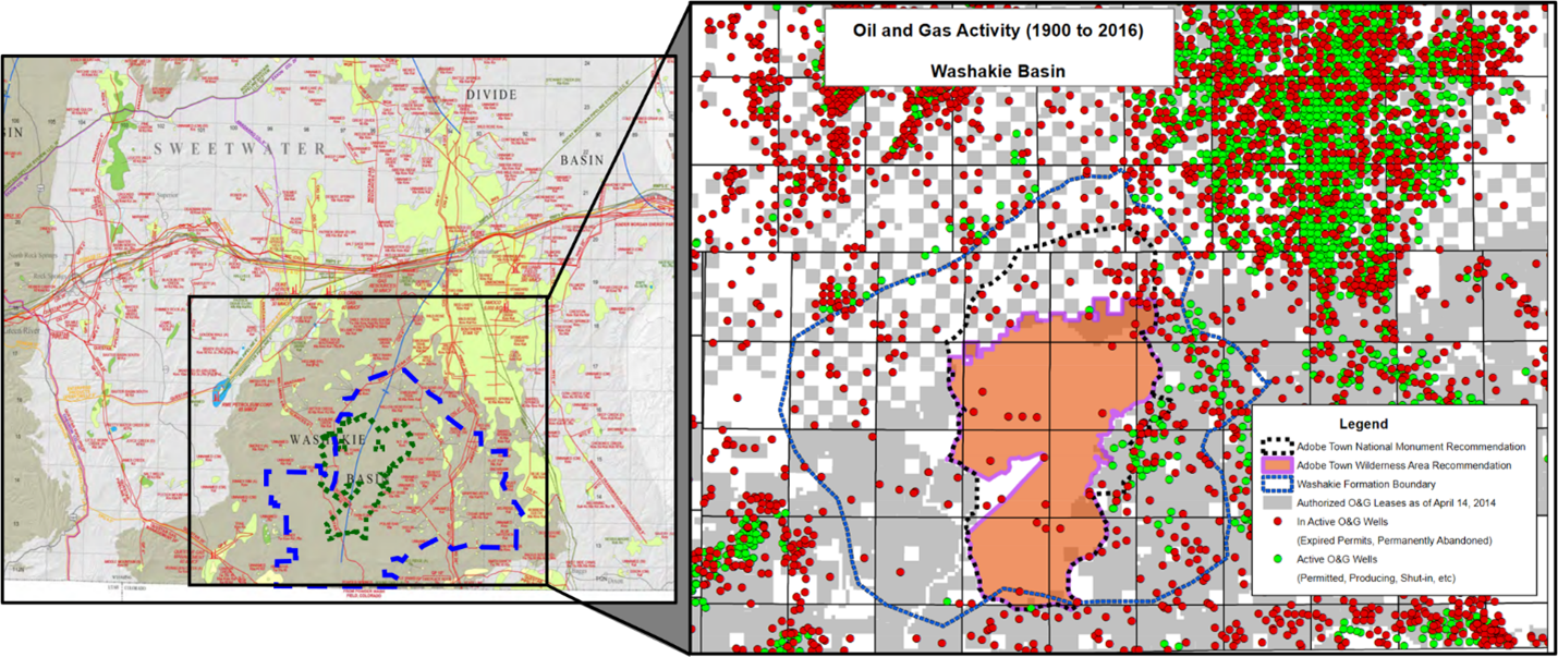
Oil and gas fields (left) and wells (right) in central Washakie Basin, Greater Green River Basin.
Image: Left: After De Bruin, R.H., 2007, Oil and gas fields map of the Greater Green River Basin and overthrust belt, southwestern Wyoming: Wyoming State Geological Survey Map Series 52, scale 1:350,000; https://www.wsgs.wyo.gov/products/wsgs-2007-ms-52.pdf:
Right: After Wyoming County Commissioners Association Washakie Basin Oil and Gas Activity. Map created by Lovejoy Consulting.
The Adobe Town badlands of the Washakie Basin area are in an isolated place with stunning vistas. It is home to Wyoming’s largest population of wild horses and provides habitat for an abundance of wildlife. The important fossil remains at Big Multi Quarry north of I-80 (ne se sw 36-23N- 99W) and those located along Bitter Creek helped ignite the “Bone Wars” of Cope and Marsh. The maze of canyons and bluffs provided hideouts and escape routes for outlaws. These amazing high desert erosonal features are possibly the last remaining truly wild badlands in the United States.
Things-To-Do
If you go, the BLM recommends a high clearence vehicle with 4-wheel drive and a spare tire. Also have a full tank of gas, carry a map, lots of water and survival supplies. Tell someone where you are going.

The material on this page is copyrighted
