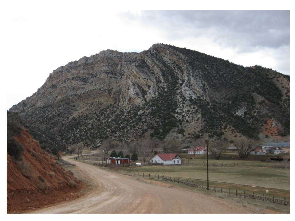
Upper Nowood Road, Chabot Anticline and Hampton Ranch Image by Mark Fisher
Wow Factor (3 out of 5 stars):

Geologist Factor (2 out of 5 stars):

Attraction
Backroad drive through scenic southeast corner of Bighorn Basin and across the gentle Owl Creek Mountains. Several large geologic folds called anticlines are exposed and cut through by streams. Miles of red Triassic Chugwater outcrops contrast with the green pastures on big cattle ranches in the Upper Nowood River Valley. This is a secluded area where time seems to have stopped 100 years ago.
Geology Nowood River
The Nowood River rises on the north flank of the eastern Owl Creek Mountains and flows north into the Bighorn Basin. Several streams flowing off the southwest flank of the Bighorn Mountains add their waters to the river after carving impressive canyons through the sedimentary rock layers. The Nowood joins the Bighorn River about halfway between Basin and Worland.
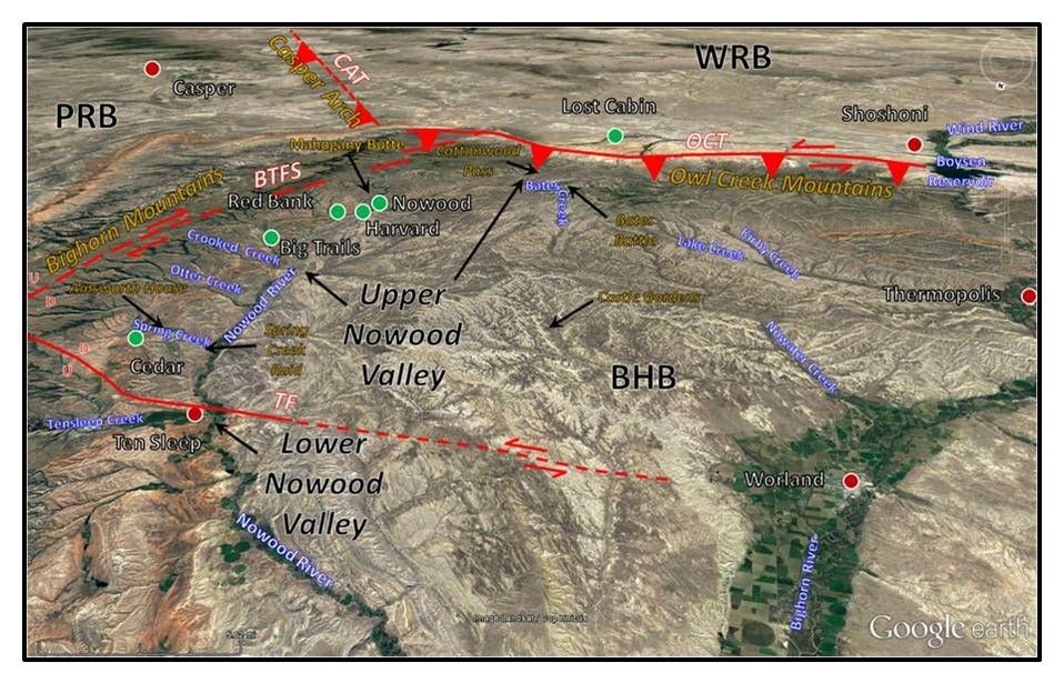
South aerial view of Nowood Valley area. Towns are shown by dots: red: current, green: former. Faults shown by red lines with triangles showing direction of dip on thrust faults, arrows show sense of lateral motion, U/D indication relative offset direction on nearly vertical faults: BTFS: Big Trails Fault System, CAT: Casper Arch Thrust, OCT, Owl Creek Thrust, TF: Tensleep Fault, BHB: Bighorn Basin, PRB: Powder River Basin, WRB: Wind River Basin.
Image: Google Earth
Image: Google Earth
In 1884 Frank Aisnworth was trapping along the Bighorn River when he encountered this river junction. He began to follow the path of the smaller stream into the valley of the Nowood. His journal relates what he found:
"I kept on moving down the Big Horn and trapping as I went until I reached the junction of the Nowood...then I worked my way up the Nowood Valley...this valley pleased me more than any other place I had ever been. It was a game paradise. Buffalo roamed over the valley by the hundreds".
He decided to settle down at the confluence of the Nowood River and Crooked Creek. He and his new wife lived in a tent while he built one of the first permanent residences in this part of the basin. The Ainsworth House was placed on the National Register of Historic Places in 1986.

Geologic map of the Nowood River watershed. Historic abandoned communities with former post offices indicated by green rectangles. Post office dates: Cedar: 1898-1902, Big Trails: 1898-1942, Red Bank: 1889-1904, Harvard: 1899-1902, Nowood: 1902-1931.
Image: After Nowood River Storage / Watershed Study Level I, 2010, Appendix H, Technical Memorandum: Geologic Assessment, Fig.2, http://www.acewater.com/wp-content/uploads/2011/05/Nowood-Final-Report-APPENDIX-H.pdf
Image: After Nowood River Storage / Watershed Study Level I, 2010, Appendix H, Technical Memorandum: Geologic Assessment, Fig.2, http://www.acewater.com/wp-content/uploads/2011/05/Nowood-Final-Report-APPENDIX-H.pdf

Left: East view from WY 434 toward the Ainsworth House. Right: The Ainsworth House.
Images: Left: Google Earth Street View; Right: https://npgallery.nps.gov/NRHP/GetAsset/0e379698-c876-4aa9-99fc-a677d9175e7e?branding=NRHP
Images: Left: Google Earth Street View; Right: https://npgallery.nps.gov/NRHP/GetAsset/0e379698-c876-4aa9-99fc-a677d9175e7e?branding=NRHP
Frank promoted the town of Red Bank and the Upper Nowood area to other prospective settlers. The Post Office was established in 1898. To avoid confusion with another town of the same name five and a half miles to the southeast, the name was changed to Big Trails. The new name came from the intersection of several Indian trails at this location.
An apocryphal story told by William Cody’s sister on when he heard of the Bighorn Basin from an Arapaho warrior speaks truth to Native American sentiment for the basin. The warrior relayed the beauty and natural abundance of the area to the Scout in 1875 and called the place “Eithity Tugala.” This loosely translates to heaven on earth.
This area is also the intersection of three major geologic structural trends: the Bighorn Mountains, the Owl Creek Mountains, and the Casper Arch. All three are basin-bounding structures that were elevated during the Laramide mountain building event that occurred about 70 million years ago. The Bighorn and Owl Creek mountains mark the southeast margin of the Bighorn Basin separating the Bighorn, Powder River and Wind River Basins. The Casper Arch separates the southern Powder River Basin from the eastern Wind River Basin. This triple junction is in the same area as accretion zones between sub-provinces of the ancient Wyoming Craton. The basement fabric established during this Precambrian tectonism greatly influenced the location and orientation of the structural arches developed during the Laramide mountain building event. Flat-plate subduction along the western margin of North America generated the compressive stress field that resulted in the crustal shortening within preexisting weakness zones of the Wyoming Craton and elevated the Rocky Mountains. The three Laramide arches that converge at the southeastern corner of the Bighorn Basin are aligned with these Precambrian boundary zones. The recently discovered suture along the eastern margin of the Bighorn Mountains is about 180 miles west of the previously recognized boundary of the Wyoming Craton.
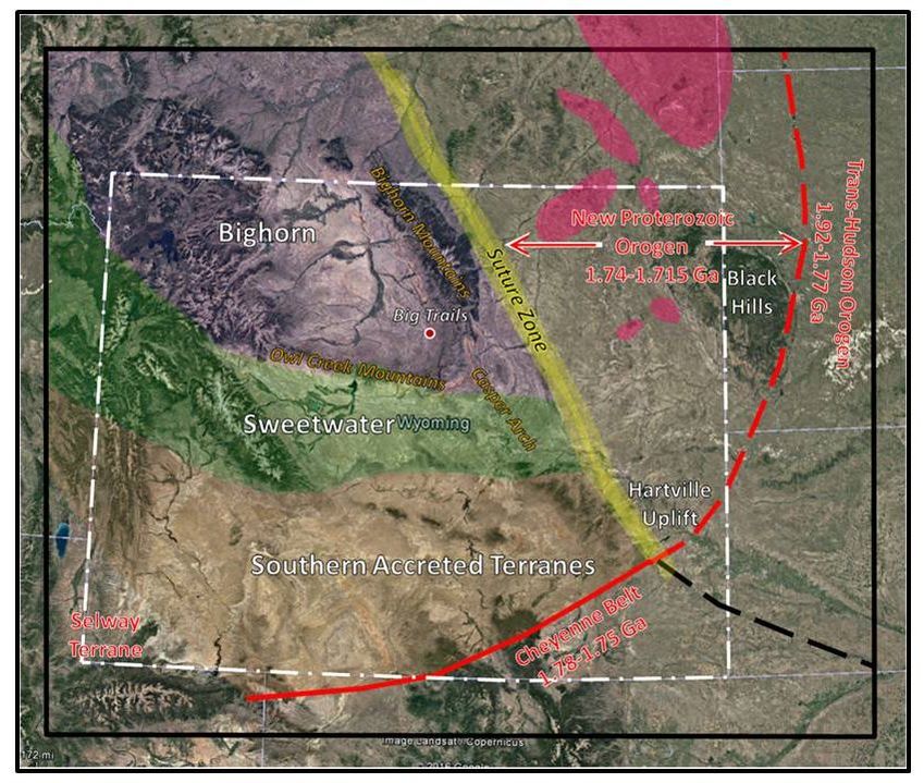
Tectonic map of the Archean Wyoming Craton. Sub-provinces: Bighorn Magmatic Terrane: purple; the Sweetwater Terrane: green; the Southern Accreted Terranes: tan. Solid red line is the location of the Cheyenne Belt suture. The dashed red line marks the previous Wyoming Craton accretion suture with the Trans-Hudson tectonic belt. The yellow area marks the recently recognized cratonic suture with Proterozoic accretions. The pink areas are magnetic anomaly zones within the new orogen area. Laramide arch trends are labeled in gold.
Image: Base: Google Earth; Data: After Worthington, L.L., Miller, K.C., Erslev, E.A., Anderson, M.L., Chamberlain, K.R., Sheehan, A.F., Yeck, W.L., Harder, S.H., Siddoway, C.S., 2016, Crustal Structure of the Bighorn Mountains Region: Precambrian Influence on Laramide Shortening and Uplift in North-Central Wyoming: to be published in Tectonics, Fig. 22B.https://www.researchgate.net/publication/288700199_Crustal_structure_of_the_Bighorn_Mountains_region_Precambrian_influence_on_Laramide_shortening_and_uplift_in_north-central_Wyoming
Image: Base: Google Earth; Data: After Worthington, L.L., Miller, K.C., Erslev, E.A., Anderson, M.L., Chamberlain, K.R., Sheehan, A.F., Yeck, W.L., Harder, S.H., Siddoway, C.S., 2016, Crustal Structure of the Bighorn Mountains Region: Precambrian Influence on Laramide Shortening and Uplift in North-Central Wyoming: to be published in Tectonics, Fig. 22B.https://www.researchgate.net/publication/288700199_Crustal_structure_of_the_Bighorn_Mountains_region_Precambrian_influence_on_Laramide_shortening_and_uplift_in_north-central_Wyoming
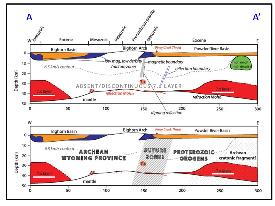
Geophysical model of seismic line A-A’. The red 7.x layer (white underline) is the high velocity, high density lower crustal layer that underlies the Bighorn and much of the Sweetwater Terranes. The model indicates that the absence or thinning of this layer may correspond to Precambrian weakness zones where deformation is localized.
Image: After Worthington, L.L., Miller, K.C., Erslev, E.A., Anderson, M.L., Chamberlain, K.R., Sheehan, A.F., Yeck, W.L., Harder, S.H., Siddoway, C.S., 2016, Crustal Structure of the Bighorn Mountains Region: Precambrian Influence on Laramide Shortening and Uplift in North-Central Wyoming: to be published in Tectonics, Fig. 22B. https://www.researchgate.net/publication/288700199_Crustal_structure_of_the_Bighorn_Mountains_region_Precambrian_influence_on_Laramide_shortening_and_uplift_in_north-central_Wyoming
Image: After Worthington, L.L., Miller, K.C., Erslev, E.A., Anderson, M.L., Chamberlain, K.R., Sheehan, A.F., Yeck, W.L., Harder, S.H., Siddoway, C.S., 2016, Crustal Structure of the Bighorn Mountains Region: Precambrian Influence on Laramide Shortening and Uplift in North-Central Wyoming: to be published in Tectonics, Fig. 22B. https://www.researchgate.net/publication/288700199_Crustal_structure_of_the_Bighorn_Mountains_region_Precambrian_influence_on_Laramide_shortening_and_uplift_in_north-central_Wyoming
The Big Trails Fault System extends about 53 miles from the Tensleep Fault in the north, to the Owl Creek Thrust at the south terminus along the southwest flank of the Bighorn Mountains. The fault has a maximum of 4,500 feet down-to-the-west vertical displacement. Horizontal motion is 2-3 miles of right-lateral slip.
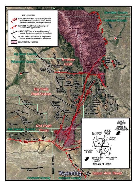
Tectonic map of southeast Bighorn Basin showing the triple junction of Laramide Arches and their bounding faults. The strain ellipse shows sense of motion on faults and fractures in response the maximum horizontal compression that occurred during the Laramide mountain-building event (N50 degrees E)
Image: Base Google Earth; Overlay: After Ver Ploeg, A.J. and Greer, P.L., 1996, Evidence for Right-Oblique-Slip on a Northern Segment of the Big Trails Fault System, Southern Big Horn Mountains, Wyoming: WGA 47th Annual Field Conference Guidebook, Fig. 1, p. 180.
Image: Base Google Earth; Overlay: After Ver Ploeg, A.J. and Greer, P.L., 1996, Evidence for Right-Oblique-Slip on a Northern Segment of the Big Trails Fault System, Southern Big Horn Mountains, Wyoming: WGA 47th Annual Field Conference Guidebook, Fig. 1, p. 180.
Chugwater Geology
WY 434 pavement ends just south of Big Trails. The unpaved Nowood Road travels within a valley walled by outcrops of the Triassic Chugwater Formation. The contrast of the red rock with the green cultivated pastures and stream valleys is stunning. The Chugwater consists of shale and siltstone in the lower and middle intervals, and becomes more sandy in the upper intervals. Total Chugwater thickness is about 1,000 feet. Depositional environment for the Chugwater is believed to be shallow marine. Individual beds in the Lower and Middle Chugwater can be followed across the basin with little change in thickness and character. The Upper Chugwater has more variability. Almost no trace of life is present in these Chugwater beds - a result of the global extinction event at the Permian-Triassic boundary that wiped out up to 96 percent of all marine species.
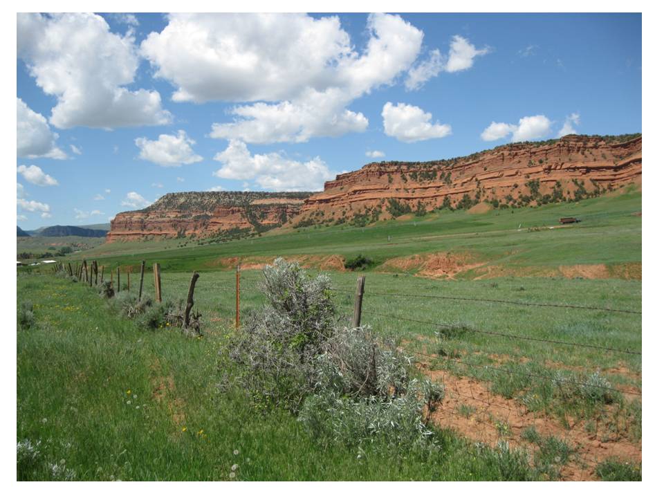
Triassic Chugwater shale, siltstones and sandstones along Upper Nowood Road. The resistant ledges are coarser grained siltstone and sandstones. These Chugwater siltstones and sandstones produce gas in the subsurface at Oregon Basin Field near Cody (see Geowyo Oregon Basin Oil Field)
Image by Mark Fisher
Image by Mark Fisher
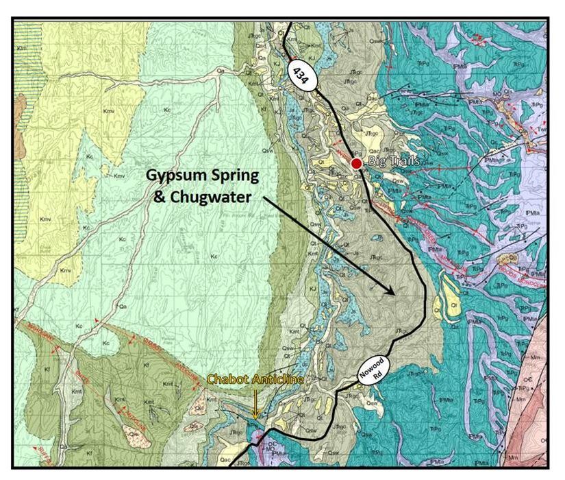
Geologic map of area from Big Trails to Chabot Anticline. WY 434/Upper Nowood Road shown by solid black line. Note how much of the road crosses Chugwater Formation. Geologic notation: Qa: Quaternary alluvium, Qt; Quaternary terrace deposits, Qls: Quaternary landslide and talus deposits, Kmv; Cretaceous Mesaverde, Kc: Cretaceous Cody Shale, Kf: Cretaceous Frontier Formation, Kmt: Mowry and Thermopolis Formations, KJ: Cretaceous Cloverly and Jurassic Morrison Formations, Js: Jurassic Sundance, Jsg: Jurassic Sundance and Gypsum Spring Formations, JTrgc: Jurassic Gypsum Spring and Triassic Chugwater Formations, Trcd: Triassic Chugwater and Dinwoody Formations, TrPg: Lower Triassic to Permian Goose Egg Formation, Pp: Permian Phosphoria Formation, PMa: Pennsylvanian Tensleep and Pennsylvanian to Upper Mississippian Amsden Formations, Mm: Mississippian Madison Limestone, MO: Mississippian Madison Limestone, Ordovician Bighorn Dolomite, OC: Lower Ordovician to Middle Cambrian Gallatin Limestone, Gros Ventre and Flathead Sandstone Formations.
Image: Ver Ploeg, A.J., 2004, Geologic map of the Nowater Creek 30' x 60' quadrangle, northcentral Wyoming: Wyoming State Geological Survey Map Series 39, 1 sheet, scale 1:100,000. (Digitized and modified from Ver Ploeg, A.J., 1992). http://www.wsgs.wyo.gov/products/wsgs-2004-ms-39.pdf
Image: Ver Ploeg, A.J., 2004, Geologic map of the Nowater Creek 30' x 60' quadrangle, northcentral Wyoming: Wyoming State Geological Survey Map Series 39, 1 sheet, scale 1:100,000. (Digitized and modified from Ver Ploeg, A.J., 1992). http://www.wsgs.wyo.gov/products/wsgs-2004-ms-39.pdf
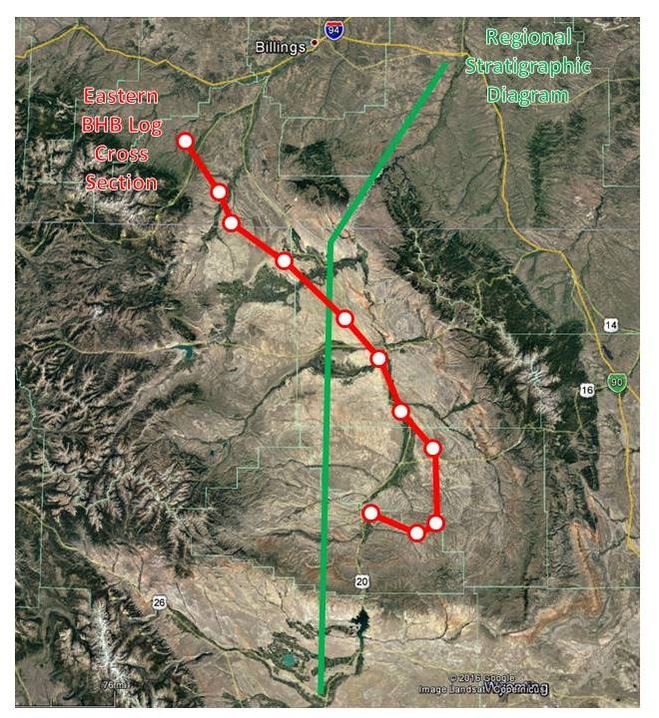
Index map to regional stratigraphic diagram and cross section of Jurassic and Triassic stratigraphy.
Image: Google Earth
Image: Google Earth
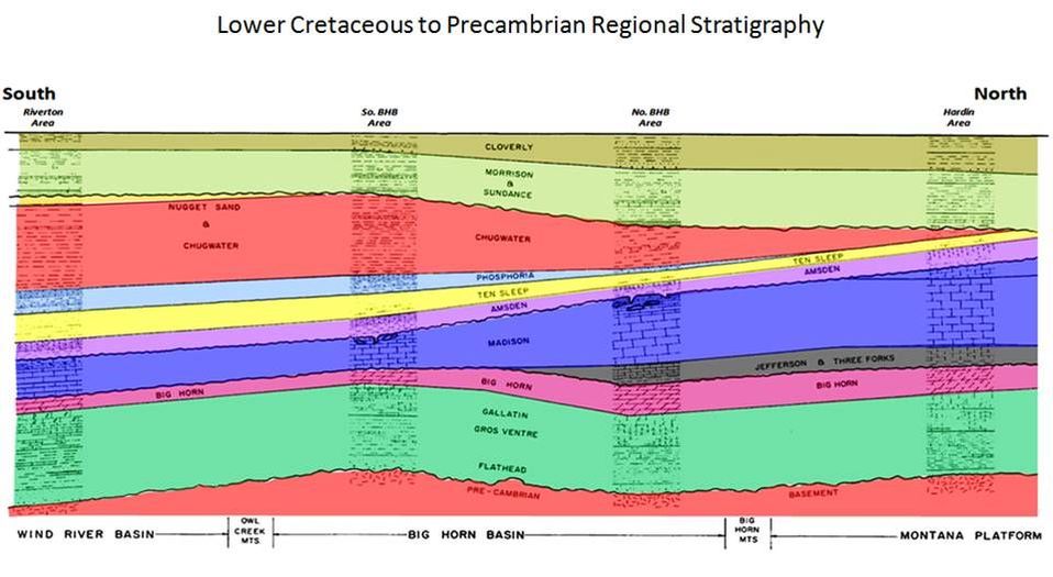
Diagram showing Chugwater (red) thinning significantly as you move north from the Wind River Basin to the Big Horn Basin to Montana. An erosional event after deposition of the Chugwater truncates the formation from the top.
After Fanshawe, J.R., 1971, Structural Evolution of Bighorn Basin: WGA Symposium on Wyoming Tectonics and Their Economic Significance; 23rd Annual Field Conference Guidebook, Exhibit 2
After Fanshawe, J.R., 1971, Structural Evolution of Bighorn Basin: WGA Symposium on Wyoming Tectonics and Their Economic Significance; 23rd Annual Field Conference Guidebook, Exhibit 2
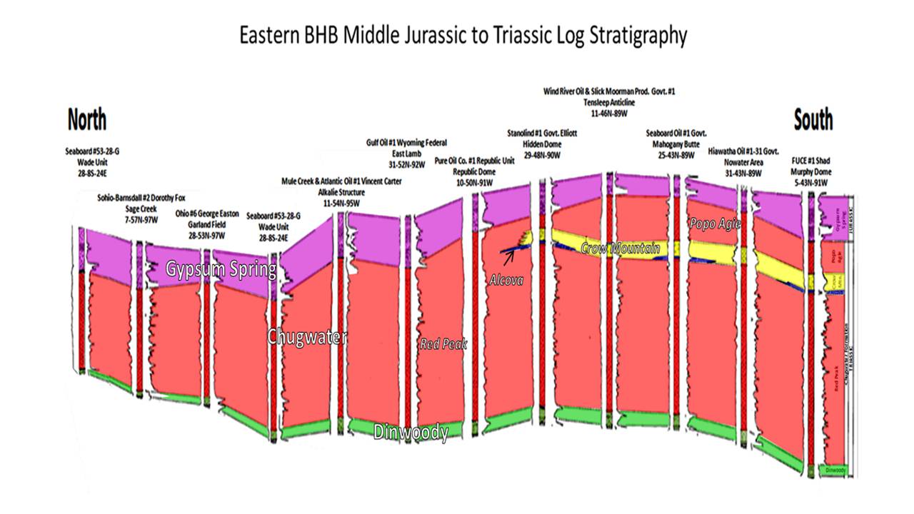
Well log cross section north to south across Bighorn Basin showing thickening of Chugwater (red) to the south due to less erosion/truncation of the upper Chugwater rocks. Ancient erosion surface is at base of Gypsum Spring (purple). The four members of the Chugwater shown above are: 1) Red Peak shales and siltstones in the Lower and Middle Chugwater, 2} Alcova very thin regionally extensive limestone shown in blue, 3) Crow Mountain sandstone shown in yellow in the Upper Chugwater, and 4) Popo Agie shales, siltstones and sandstones in the Upper Chugwater.
After Mills, N.K., American Stratigraphic Co. for Wyoming Geological Association Nomenclature Committee, 1956, Subsurface Correlation in the Bighorn Basin, Wyoming: WGA Wyoming Stratigraphy: Subsurface Stratigraphy of the Pre-Niobrara Formations in Wyoming
After Mills, N.K., American Stratigraphic Co. for Wyoming Geological Association Nomenclature Committee, 1956, Subsurface Correlation in the Bighorn Basin, Wyoming: WGA Wyoming Stratigraphy: Subsurface Stratigraphy of the Pre-Niobrara Formations in Wyoming
About 12.5 miles south of Big Trails (4,855 feet ASL) the route passes through Chabot Anticline. Where the Nowood River has cut through the axis of the fold exposing Paleozoic rocks. The structural relief is over 1,450 feet. This is an example of erosion by a superposed stream.
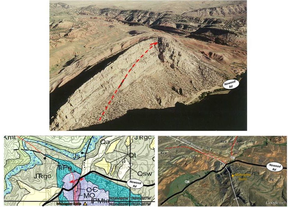
Roadway passing through Chabot Anticline. Top: Aerial view of northwest plunging structure. A probable bedding plane detachment thrust can be seen by offset in the Tensleep Sandstone. Bottom Left: Geologic map of a portion of Chabot Anticline. WY 434 roadway shown by black line. Geologic notation: Qa: Quaternary alluvium, Kmt: Cretaceous Mowry and Thermopolis Formations, Js: Jurassic Sundance Formation, JTrgc: Jurassic Gypsum Spring and Triassic Chugwater Formations, TrPg: Triassic-Permian Goose Egg Formation, PMta, Pennsylvanian Tensleep and Pennsylvanian-Upper Mississippian Amsden Formations, MO: Middle Mississippian Madison and Middle Ordovician Bighorn Formations, OC: Lower Ordovician-Middle Cambrian undesignated formations. Bottom Right: Aerial view of Chabot Anticline. Note: Mahogany Butte is located on the crest of this structure and not on the Mahogany Butte Anticline which is a mile to the southwest and developed in Lower Cretaceous rocks across Buffalo Creek. Geologic notation: Qa: Quaternary alluvium, Kcv: Cretaceous Cloverly Formation, Jm: Jurassic Morrison Formation, Js: Jurassic Sundance Formation, Jgs: Jurassic Gypsum Spring Formation, Trc: Triassic Chugwater, Pg: Permian Goose Egg Formation, Pt: Pennsylvanian Tensleep Formation, Pa: Pennsylvanian Amsden Formation, Mm: Mississippian Madison Formation.
Images: Top: Wheeler, D.M., 1986, Stratigraphy and Sedimentology of the Tensleep Sandstone, Southeast Bighorn Basin: M.S. Thesis, Colorado School of Mines, Fig. 6, p. 20. https://dspace.library.colostate.edu/handle/11124/170478?show=full
Bottom Left: Ver Ploeg, A.J., 2004, Geologic map of the Nowater Creek 30' x 60' quadrangle, northcentral Wyoming: Wyoming State Geological Survey Map Series 39, 1 sheet, scale 1:100,000. (Digitized and modified from Ver Ploeg, A.J., 1992). http://www.wsgs.wyo.gov/products/wsgs-2004-ms-39.pdf; Bottom: Right: Google Earth.
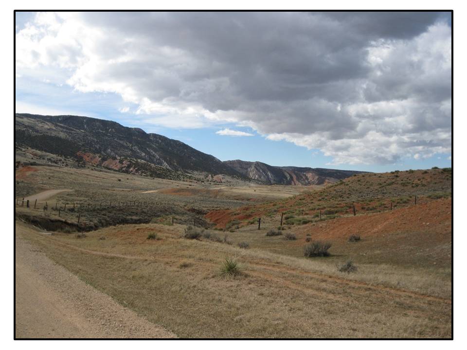
After another 11.5 miles the route veers from the Nowood Valley (5,890 feet ASL) at the intersection with Bates Creek Ranch Road (See below for Bates Battlefield ) and climbs 1,837 feet in elevation over the 6 mile distance to Cottonwood Pass (6,727 feet ASL). The roadway follows a facies change in the Permian rocks. Continental Goose Egg Formation is to the east, while marine Phosphoria (Park City Formation) is to the west. The Nowood road is traveling on Mid Eocene (49-45 million years ago) Wagon Bed Formation. This Tertiary unit consists of volcanic sediment from the Absaroka Volcanic Field that was deposited in a warm, shallow lake (see Geowyo Absaroka Volcanic Province). The lithology is greenish-grey, tuffaceous claystone, sandstone and conglomerate. The non-volcanic clasts within the conglomerate beds were sourced from the exposed Precambrian core of the Bighorn Mountains.
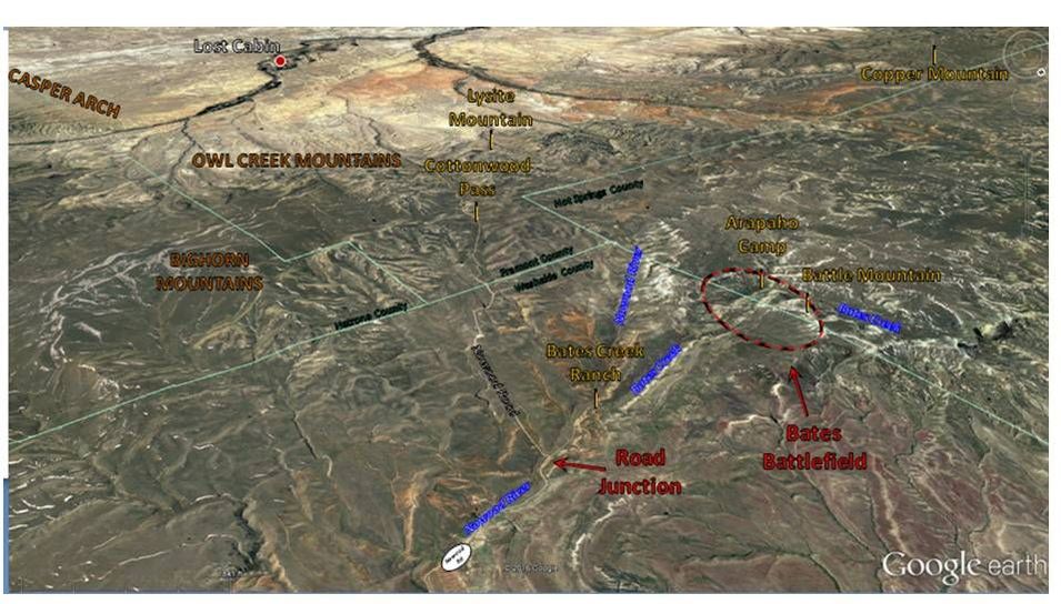
South aerial view of Nowood Road junction with Bates Creek Ranch Road.
Image: Google Earth
Image: Google Earth
From this point the road descends 9.5 miles from the Owl Creek Mountains along Cottonwood Creek to Badwater Creek. Follow Badwater Creek for 5 miles to Lost Cabin (5,430 feet ASL). WY 434 follows a Native American tail between Lost Cabin and Big Trails. It is also the route the stage line carried the mail before railroad service. Today the route remains as it always was – a journey through a corner of the Bighorn Basin that is a bit of “heaven on earth.”

Annotated geologic map of area from Chabot Anticline to Bates Creek Battlefield site. Nowood Road shown by solid black line, mainly on Chugwater. Bates Creek Ranch Road shown by dashed black line. Geologic notation: Qa: Quaternary alluvium, Qt; Quaternary terrace deposits, Qls: Quaternary landslide and talus deposits, Twb: Tertiary Wagon Bed Formation, Kc: Cretaceous Cody Shale, Kf: Cretaceous Frontier Formation, Kmt: Mowry and Thermopolis Formations, KJ: Cretaceous Cloverly and Jurassic Morrison Formations, Js: Jurassic Sundance, Jsg: Jurassic Sundance and Gypsum Spring Formations, JTrgc: Jurassic Gypsum Spring and Triassic Chugwater Formations, Trcd: Triassic Chugwater and Dinwoody Formations, TrPg: Lower Triassic to Permian Goose Egg Formation, Pp: Permian Phosphoria Formation, PMa: Pennsylvanian Tensleep and Pennsylvanian to Upper Mississippian Amsden Formations, Mm: Mississippian Madison Limestone, MO: Mississippian Madison Limestone, Ordovician Bighorn Dolomite, OC: Lower Ordovician to Middle Cambrian Gallatin Limestone, Gros Ventre and Flathead Sandstone Formations.
Image: After Ver Ploeg, A.J., 2004, Geologic map of the Nowater Creek 30' x 60' quadrangle, northcentral Wyoming: Wyoming State Geological Survey Map Series 39, 1 sheet, scale 1:100,000. (Digitized and modified from Ver Ploeg, A.J., 1992). http://www.wsgs.wyo.gov/products/wsgs-2004-ms-39.pdf. Arapaho Village Inset Image: https://indianspictures.blogspot.com/2011/12/arapaho-american-indian-pictures.html
Image: After Ver Ploeg, A.J., 2004, Geologic map of the Nowater Creek 30' x 60' quadrangle, northcentral Wyoming: Wyoming State Geological Survey Map Series 39, 1 sheet, scale 1:100,000. (Digitized and modified from Ver Ploeg, A.J., 1992). http://www.wsgs.wyo.gov/products/wsgs-2004-ms-39.pdf. Arapaho Village Inset Image: https://indianspictures.blogspot.com/2011/12/arapaho-american-indian-pictures.html
What You Will See On Nowood River Road
This is a beautiful, peaceful drive - especially from Ten Sleep along the Nowood River to the top of the Owl Creek Mountains. The road down from the Owl Creeks to Moneta in the Wind River Basin is rather barren and crosses Madden Field, one of the largest gas fields in the state. We don't have any hikes or geology stops to suggest at this time. This trip is all about exploring a secluded place with your vehicle. The best time to take this route is spring when there is an attractive contrast between the red outcrops and the green grass. It is 77 miles one way and takes about two hours. From Ten Sleep, the first 21 miles on WY 434 are paved, the next 43 miles along the Upper Nowood Road and over the Owl Creeks to Lost Cabin is gravel, and the last 13 miles to Moneta are paved. The road is fine for a 2WD passenger car. However, there is no road maintenance from October through April over the Owl Creeks. There is minimal traffic, no services, poor cell coverage and occasional cattle on the road. We do not recommend this road if it is wet or snowy. If you don’t have the time to drive the entire road, we suggest you drive the first 35 miles south from Ten Sleep. If you are traveling between Ten Sleep and Casper, you should consider taking this backroad at least once because it will only add about 30 minutes to your trip. Enjoy!
Upper Nowood Road approaching from the north the canyon cut through Chabot Anticline.
Image by Mark Fisher
Image by Mark Fisher
Directions Ten Sleep to Moneta through Upper Nowood River Valley
Starting in downtown Ten Sleep, head south on WY 434 toward Big Trails, 0.3 miles cross Tensleep Creek with red Triassic Chugwater along creek, 6.7 miles Spring Creek Raid monument and historical sign on left (write-up about raid in Geowyo Castle Garden), 7.3 miles Spring Creek Road (County 58) on left, 11.8 miles cross Otter Creek, 16.1 to 18.1 miles Chugwater outcrops on both sides, 19.0? miles Ainsworth cabin on left, 20.4 miles straight at cattle guard at Big Trails, end of WY 434 & start of County 82; Spring Creek Road County 58 and County 85 on left, 20.9 miles pavement ends, Chugwater outcrops, 24.1 miles large geologic fold on left called Little Canyon Creek anticline/monocline with Paleozoics in core, 26.3 miles Chugwater cliffs on right, 28.3 miles Boxelder Ranch, 28.9 miles Cherry Creek Road (County 80) on left, 29.6 miles Tolman Ranch, 33.0 miles cross Nowood River, Hampton Ranch and Chabot Anticline with Pennsylvanian Tensleep Sandstone outcrops, 33.3 miles tight core of Chabot fold with Madison and Bighorn outcrops on left, federal land between bridges, 33.6 miles Orchard Ranch, 33.7 miles cross Nowood River, Phosphoria and Dinwoody outcrops on right, 34.5 miles bridge over Nowood River, 35.4 miles cliffs of Tensleep Sandstone on left, Chugwater cliffs on right, 35.9 miles “Nowood International Airport”, 36.8 miles small canyon on left with Tensleep Sandstone, 36.9 miles Cherry Creek Road (County 80) on left, 39.7 miles tight fold on left along Nowood River called North Orchard Anticline with Tensleep Sandstone in core, 40. 3 miles Chugwater siltstone and shales bending around north plunge of North Orchard Anticline, 43.3 miles small reservoir on left, 44.7 miles turnoff on right for Bates Creek and Bates battlefield site (no public access), 46.0 miles drive up Owl Creeks on dip slope of Phosphoria, Tensleep and Tertiary Wagon Bed Formation, 48.4 miles cross from Washakie to Fremont County, 50.6 miles highest elevation on road at Cottonwood Pass, Paleozoics on left and right, 55.0 miles leave last outcrops of Owl Creeks and enter basin topography, 57.7 miles Big Horn Trail merges from left, safety/warning signs for Madden Field, approximate location in the subsurface of the large Owl Creek Thrust Fault that marks the boundary between the Owl Creek Mountains and Wind River Basin, upthrown side of fault to north, 60.2 miles Badwater Road merges from left, 61.9 miles Spratt Ranch, 63.4 miles start of pavement, Madden Gas Field, large industrial facility on left is gas plant that removes poisonous CO2 and H2S from the natural gas, Madden total cumulative production of 2.6 trillion cubic feet of gas is equal to about a tenth of what the US uses in one year, 64.2 miles oil storage tanks and pipelines, 65.2 miles town of Lost Cabin, turn right at stop sign onto Fremont County 117, 68.1 miles town of Lysite, 68.4 miles turn left at stop sign on Lysite-Moneta Road Fremont County 176, 68.5 miles cross railroad tracks, 68.8 miles cross Badwater Creek, 76.8 miles arrive at Moneta, intersection with US 20-26, turn right for Shoshoni (21 miles) or turn left for Casper (78 miles).
Bates Battlefield
The Bates Battle (aka the Nowood Battle, the Battle of Snake Mountain and Battle of Young's Point) was a minor skirmish between the US Calvary, with Shoshone warriors, against an encampment of Arapaho Indians. The previous summer a band of Lakota Sioux were raiding in the Sweetwater Mining District of the Wind River Basin. While their objective was mainly cattle and horses, some people were killed in the attacks. The next spring the Army pursued the raiders who had returned home with the arrival of winter. An Arapaho encampment (not the Lakota raiders from the summer before) was discovered by Shoshone army scouts in a valley along Bates Creek at the base of Battle Mountain.
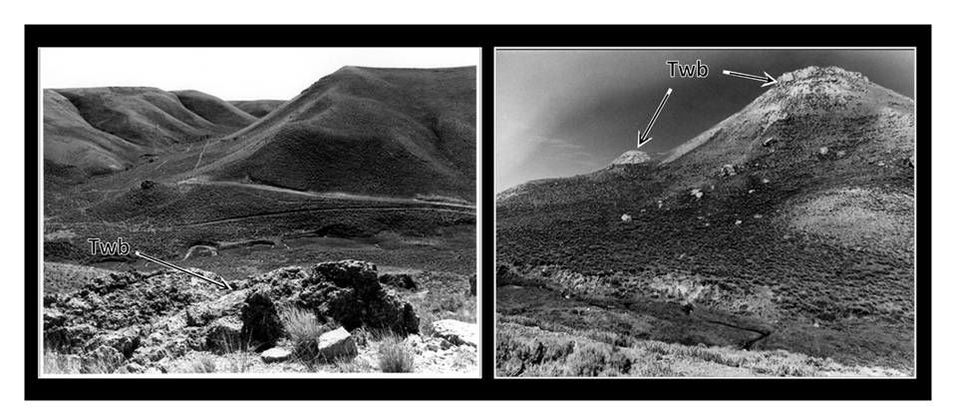
Left: View south towards Arapaho encampment site from Battle Mountain. Right: View north towards Battle Mountain from Bates Creek. The buttes in the area are preserved by a caprock of resistant sandstone in the Wagon Bed Formation. Geologic notation: Twb: Tertiary Wagon Bed Formation.
Images: Junge, M., 1973, Property Photograph Form, National Register of Historic Places, https://npgallery.nps.gov/pdfhost/docs/NRHP/Photos/74002286.pdf
Images: Junge, M., 1973, Property Photograph Form, National Register of Historic Places, https://npgallery.nps.gov/pdfhost/docs/NRHP/Photos/74002286.pdf
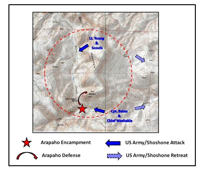
Best guess battle reconstruction from various accounts.
Image: Google Earth, USGS Earth Point Topo Map
Image: Google Earth, USGS Earth Point Topo Map
At 7:30 AM, on the Fourth of July 1874, the bugles of Company B of the 2nd Calvary sounded the charge and the battle began. Whether the engagement lasted only minutes or continued as long as four hours is debated. What is clear is that early Army success was squandered when the Arapaho gained the high ground on the resistant Wagon Bed Sandstone on Battle Mountain. The army had suffered two fatalities and three wounded. The Shoshone had two warriors killed and two injured. The Army, running out of ammunition, soon withdrew to Camp Brown (Fort Washakie). On Arapaho casualties, two historians wrote:
"In Retrospect ~ Crystal-clear Bates creek, meandering through the peaceful little badland valley, flowed crimson that morning. Within half an hour 29 known dead lay stiffening along the stream; among rocks and sagebrush. Many more hostile Indians gave their lives in defense of the village. Their exact number will forever remain a secret of surrounding buttes and draws.”
Knoefel, H.K., 1969, Wyoming's Bloodiest Fourth of July,
Northern Wyoming Daily News, Worland
“…other tribes would later refer to 1874 as ‘The Year they killed the Arapaho.’”
O’Gara, G., 2002, What You See in Clear Water
First Vintage Departures Edition, New York
Accounts vary on this skirmish, often with disagreements by all parties involved. The Bates Battle of 1874 and the Bennett Buttes Battle of 1878 (see Clarks Fork Canyon site, Park County) were the only two engagements between US Calvary and Indians within the Bighorn Basin. It was through the Arapaho exploitation of the butte topography along Bates Creek (the result of geologic processes) that they avoided annihilation. This latter punitive act by the US Army on a band of Native Americans not responsible for the previous summer’s trouble did little more than inflame the desire for revenge in the Arapaho. A revenge that was extracted on the Seventh Calvary near the banks of the Little Bighorn in two years’ time.

The material on this page is copyrighted