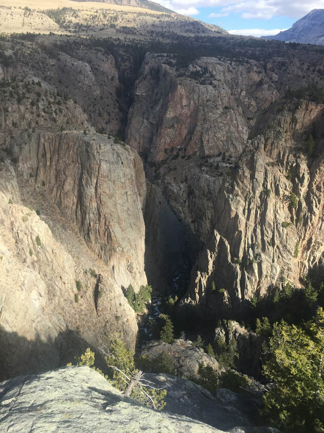
Sunlight Creek confluence with Clarks Fork Canyon
Photo by Mark Fisher
Photo by Mark Fisher
Wow Factor (4 out of 5 stars):
Geologist Factor (4 out of 5 stars):
Attraction:
One of the prettiest places in Wyoming with remote mountains, historic mining remains, permanent snowfields & glaciers, creeks, waterfalls, canyons, and wildlife. Geology includes a volcanic complex, granitic basement, the Heart Mountain Detachment Slide and Pleistocene glaciation.
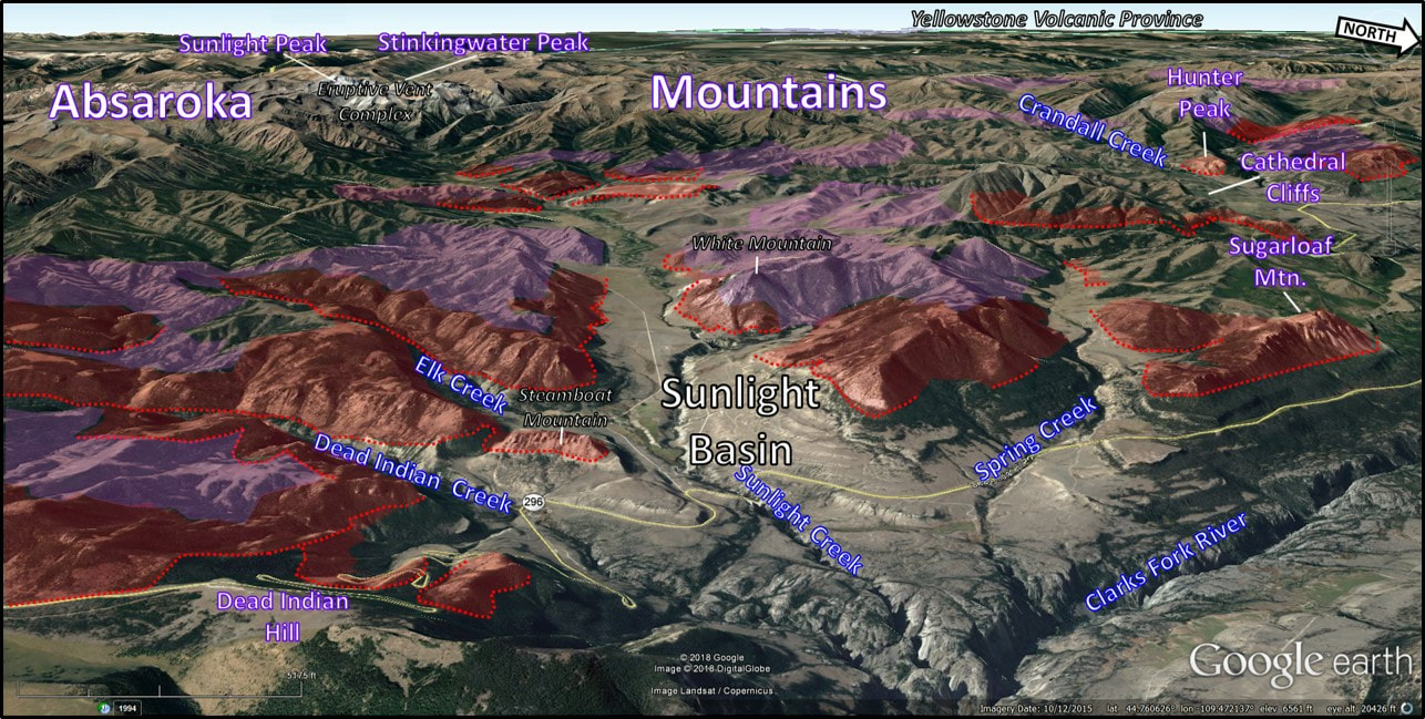
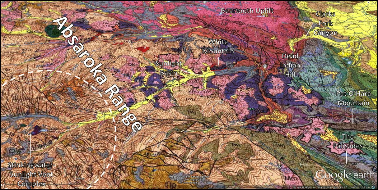
West aerial view of Sunlight Basin area. Heart Mountain detachment blocks indicated with red dotted line on fault, red highlight on transported Paleozoic rocks, and pink on transported volcanic rocks.
Image: Google Earth; Data: After Pierce, W.G., 1997, Geologic map of the Cody 1 degree X 2 degree quadrangle, northwestern Wyoming: U.S. Geological Survey, Miscellaneous Geologic Investigations Map I-2500, scale 1:250,000; https://ngmdb.usgs.gov/ngm-bin/pdp/zui_viewer.pl?id=1337.
Image: Google Earth; Data: After Pierce, W.G., 1997, Geologic map of the Cody 1 degree X 2 degree quadrangle, northwestern Wyoming: U.S. Geological Survey, Miscellaneous Geologic Investigations Map I-2500, scale 1:250,000; https://ngmdb.usgs.gov/ngm-bin/pdp/zui_viewer.pl?id=1337.
History of Sunlight Basin
Sometime in the 1800s a group of prospectors or fur trappers were trapped in the mountains by a dense fog. When the sun finally broke through, the entire basin was flooded with sunlight (Urbanek, M., 2004, Wyoming Place Names). Someone is said to have remarked "the only thing that can get into this valley most of the year, is sunlight" (Wyoming Contractors Association, 2016, Facebook). The name Sunlight has been attached to the area ever since.
In the late 1830s, when bison disappeared from the Snake River Plain in Idaho, the Bannock tribe began annual migrations to the Plains in the east to hunt bison. They followed the Bannock Trail through Sunlight Basin. Their last migration was in 1878 when they clashed with the U. S. Army. The Nez Pierce under Chief Joseph followed the Bannock Trail through here in 1877 trying to avoid capture by the U.S. Calvary on their attempted escape to Canada.
The Aide-de-Camp for General Phillip Sheridan’s 1881 Army expedition wrote about their route over Dead Indian Pass. “We arrived in camp on the unnamed creek next west of Dead Indian Creek [Sunlight Creek] a little after noon, enthusiastic about and inspirited by the grand scenery surrounding us, but with knees a little shaky by reason of walking and sliding down the steep declivity spoken of, and at the same time managing our horses so they might not fall atop us should their footing give way.” Gen. Sheridan noted that the descent of about 1,900 feet was in less than a mile. “Horse and man did considerable sliding in getting down the precipitous descent.”
Chief Joseph Highway (Wyoming Highway 296) follows the Bannock Trail route through Sunlight Basin and over Dead Indian Pass. Construction of the highway began in 1968, but due to steep terrain and unstable Cambrian and Devonian shales construction was not completed until 1995.
The Sunlight mining region (originally named Telluride) was active in the late 19th and early 20th centuries. The first claim was filed by John Painter in September of 1890. An early mining camp, Lee City, was founded on Sunlight Creek about two miles upstream of its confluence with Sulphur Creek. Eventually 1,111 claims were filed here, with 38% filed between 1890 and 1910. Most of the prospecting occurred within the six-year period 1903-1908. Several hundred feet of shafts and adits explored mineralized veins in the region. Known mineral deposits are associated with volcanic intrusive bodies. The 100 metric tons of ore (gold, silver, copper, and lead) sold in 1903 is the only known mining from the region. The value of the load is unknown. The area was never designated a mining district. A grab sample from the dump pile at Lee City prospect mine adit in 1980 assayed a trace of gold (Au), silver (Ag 0.2 oz/ton), copper (Cu 0.01 percent), lead (Pb, .02) and zinc (Zn 0.02 percent), which is probably a good average for the entire mining region.
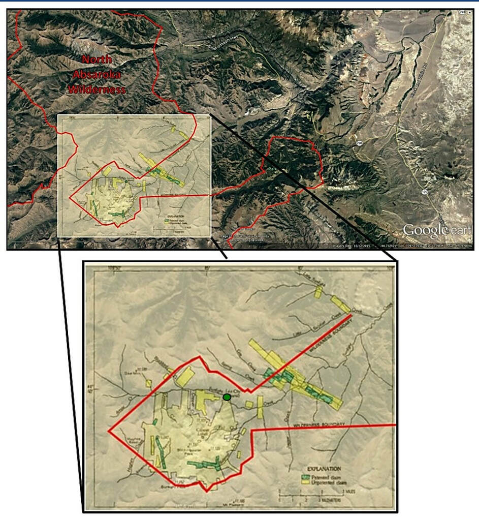
Sunlight mining region claim locations. Yellow highlighted areas are unpatented (Federal government maintains mineral rights), green highlighted areas are patented claims (Federal government surrenders all rights to a private owner of claim). Red line indicates wilderness boundary area. Most claims lie outside the North Absaroka Wilderness (designated, 1964). Green dot shows the location of abandoned Lee City.
Image: Base: Google Earth; Overlay:Nelson, W.H., Prostka, H.J., and Williams, F.E., 1980, Geology and Mineral Resources of the North Absaroka Wilderness and Vicinity, Park County, Wyoming: U. S. Geological Survey Bulletin 1447, Fig. 14, p. 37; https://pubs.er.usgs.gov/publication/b1447.
Image: Base: Google Earth; Overlay:Nelson, W.H., Prostka, H.J., and Williams, F.E., 1980, Geology and Mineral Resources of the North Absaroka Wilderness and Vicinity, Park County, Wyoming: U. S. Geological Survey Bulletin 1447, Fig. 14, p. 37; https://pubs.er.usgs.gov/publication/b1447.
Geology of Sunlight Basin
The Absaroka (pronounced ab-ZORE-kuh) Mountain Range are the remnants of a large volcanic field that was active for 10 million years during the Middle Eocene, 53-43 million years ago (see https://www.geowyo.com/absaroka-volcanic-province.html). Two chains of large composite stratovolcanoes produced mainly andesitic and basaltic volcanic rocks. The rocks include lahar and flow breccias, lava flows, and tuffs that overlie Paleozoic and Mesozoic strata. Geologist Kent Sundell has suggested that an ancient basinal area he called the Absaroka Basin developed during the Late Cretaceous Laramide Orogeny that continued into the Tertiary. The Absaroka basin structures are buried beneath volcanic rocks and are poorly exposed along the edges of the volcanic pile. Dikes and intrusions penetrate both the sedimentary sequence and volcanic rocks, often developing a radial, sunburst pattern around vent complexes.
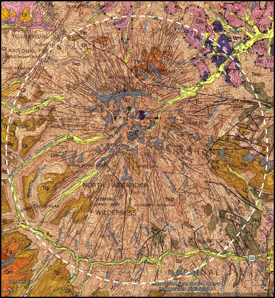
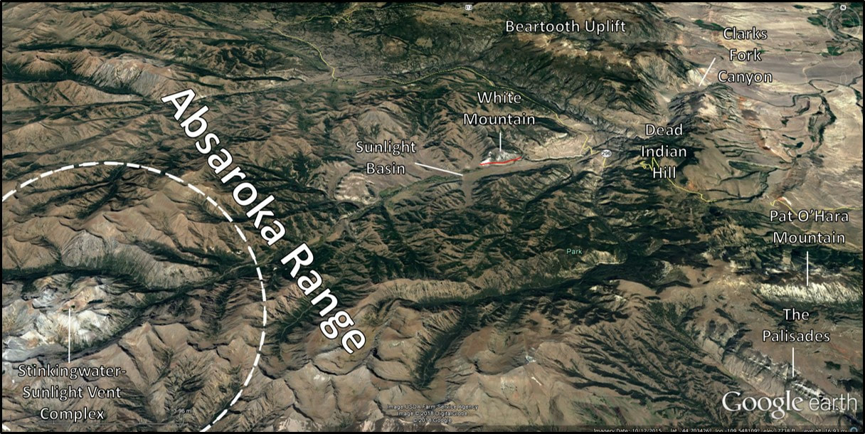
Stinkingwater and Sunlight Peaks vent complex with a radiating pattern of volcanic intrusions (white dashed line).
Image: After Pierce, W.G., 1997, Geologic map of the Cody 1 degree X 2 degree quadrangle, northwestern Wyoming: U.S. Geological Survey, Miscellaneous Geologic Investigations Map I-2500, scale 1:250,000; https://ngmdb.usgs.gov/ngm-bin/pdp/zui_viewer.pl?id=1337.
Image: After Pierce, W.G., 1997, Geologic map of the Cody 1 degree X 2 degree quadrangle, northwestern Wyoming: U.S. Geological Survey, Miscellaneous Geologic Investigations Map I-2500, scale 1:250,000; https://ngmdb.usgs.gov/ngm-bin/pdp/zui_viewer.pl?id=1337.
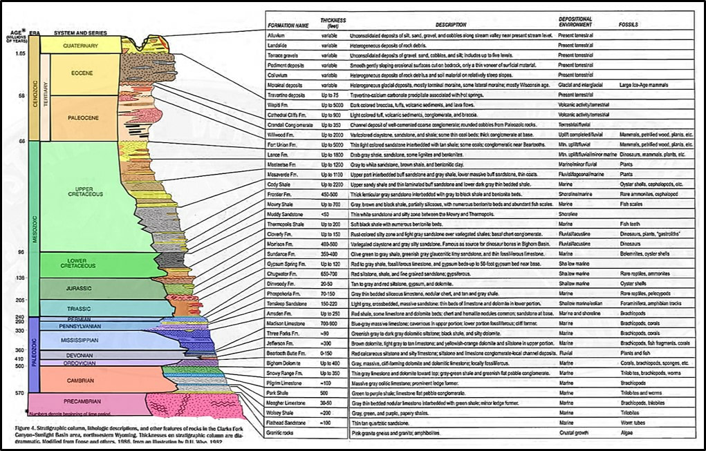
Sunlight Basin stratigraphic column.
Image: After Heasler, H.P., Jaworoski, C., Jones, R.W., De Bruin, R.P., Ver Plog, A.J., 1996, A Self-Guided Tour of the Chief Joseph Highway and Surrounding Area, Northwestern, Wyoming: Wyoming State Geological Survey Public Information Circular No. 35, Fig. 4, p. 8-9; http://www.wsgs.wyo.gov/products/wsgs-1996-pic-35.pdf.
Image: After Heasler, H.P., Jaworoski, C., Jones, R.W., De Bruin, R.P., Ver Plog, A.J., 1996, A Self-Guided Tour of the Chief Joseph Highway and Surrounding Area, Northwestern, Wyoming: Wyoming State Geological Survey Public Information Circular No. 35, Fig. 4, p. 8-9; http://www.wsgs.wyo.gov/products/wsgs-1996-pic-35.pdf.
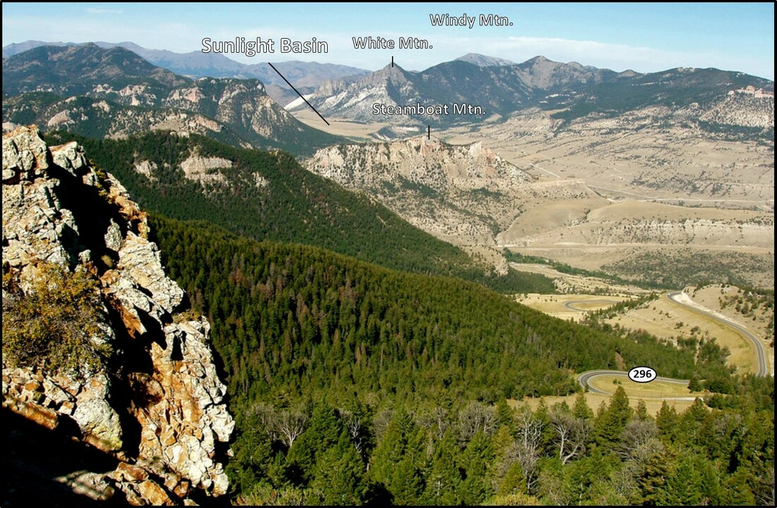
The Heart Mountain Detachment fault is a flat-lying feature that lies beneath displaced blocks of Paleozoic sedimentary rock and Eocene volcanic rock. The mountain-size blocks of Paleozoic rock capped with chocolate brown volcanics visible from Dead Indian Hill overlook are all part of the world’s largest terrestrial landslide. This massive tonnage of rock moved catastrophically on a two-degree slope about 48.9 million years ago. Their movement was towards the overlook at incredible velocity. The entire area of detached blocks could have been emplaced in as little as a few minutes to hours. Some of the blocks moved up to eighteen miles from their breakaway zone in the northeast corner of Yellowstone Park into Sunlight and Clarks Fork area, over Dead Indian Hill, and continued south and southwest on to the floor of the Eocene Bighorn Basin onto Willwood Formation. (see https://www.geowyo.com/heart-mountain.html; https://www.geowyo.com/dead-indian-hill.html; Tatman Mountain and Squaw Peaks link).
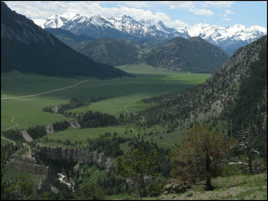
West view into Sunlight Basin from Dead Indian Hill. Compare with first image to see detached blocks and in-place strata. Wyoming Highway 296 (Chief Joseph Highway) winds its way down Dead Indian Hill to Sunlight Basin and the Clarks Fork Valley.
Image: Caryl, 2017, Only In Your State; https://www.onlyinyourstate.com/wyoming/underrated-wy-highway/.
Image: Caryl, 2017, Only In Your State; https://www.onlyinyourstate.com/wyoming/underrated-wy-highway/.
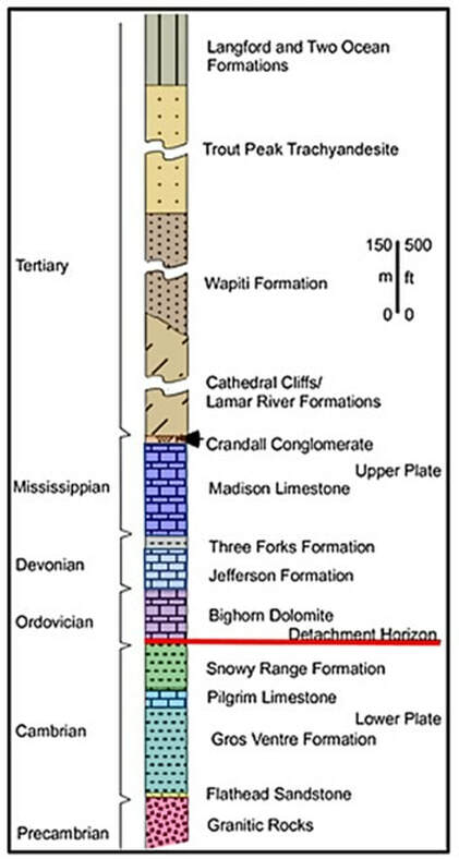
Generalized stratigraphic column of rocks in the areas where the Heart Mountain slide started. Lower-plate rocks below the fault range in age from Archean to Ordovician. The detachment occurs along a bedding plane near the base of the Bighorn Dolomite (6 to 10 feet above its base). Detached (allochthonous) Paleozoic rocks range in age from Ordovician to Mississippian. Eocene volcanic rocks of the Cathedral Cliffs and Wapiti Formation were included in the slide event. The Trout Peak Trachyandesite and the Langford are undeformed, they are younger than the movement on the fault.
Image: After Malone, D.H., Craddock, J.P., Anders, M.H., and Wulf, A., 2014, Constraints on the Emplacement Age of the Heart Mountain Slide, Northwest Wyoming: Journal of Geology, Vol. 122. Fig. 2. P. 673; https://www.jstor.org/stable/10.1086/678279?read-now=1&seq=3#page_scan_tab_contents.
Image: After Malone, D.H., Craddock, J.P., Anders, M.H., and Wulf, A., 2014, Constraints on the Emplacement Age of the Heart Mountain Slide, Northwest Wyoming: Journal of Geology, Vol. 122. Fig. 2. P. 673; https://www.jstor.org/stable/10.1086/678279?read-now=1&seq=3#page_scan_tab_contents.
The best accessible exposure of the detachment surface near the breakaway area, and the cataclastic material associated with it, is at White Mountain on the north side of the Sunlight Basin. The southwest spur of the mountain is coarse-grain white marble. It is metamorphized Mississippian Madison Limestone from contact with the intrusive plug that stands vertically above the carbonate. The marble is cut by several dikes that occur only in the upper plate (“rootless”). There is no marble in the lower plate. The intrusion and metamorphism are therefore older than the movement of the Heart Mountain detachment. The marble and upper plate intrusions were transported to their present location with the detached blocks.
North aerial view of White Mountain area.
Image: Google Earth
Image: Google Earth
Greater White Mountain area geologic map.
Image: : After Pierce, W.G., 1997, Geologic map of the Cody 1 degree X 2 degree quadrangle, northwestern Wyoming: U.S. Geological Survey, Miscellaneous Geologic Investigations Map I-2500, scale 1:250,000; https://ngmdb.usgs.gov/ngm-bin/pdp/zui_viewer.pl?id=1337.
Image: : After Pierce, W.G., 1997, Geologic map of the Cody 1 degree X 2 degree quadrangle, northwestern Wyoming: U.S. Geological Survey, Miscellaneous Geologic Investigations Map I-2500, scale 1:250,000; https://ngmdb.usgs.gov/ngm-bin/pdp/zui_viewer.pl?id=1337.
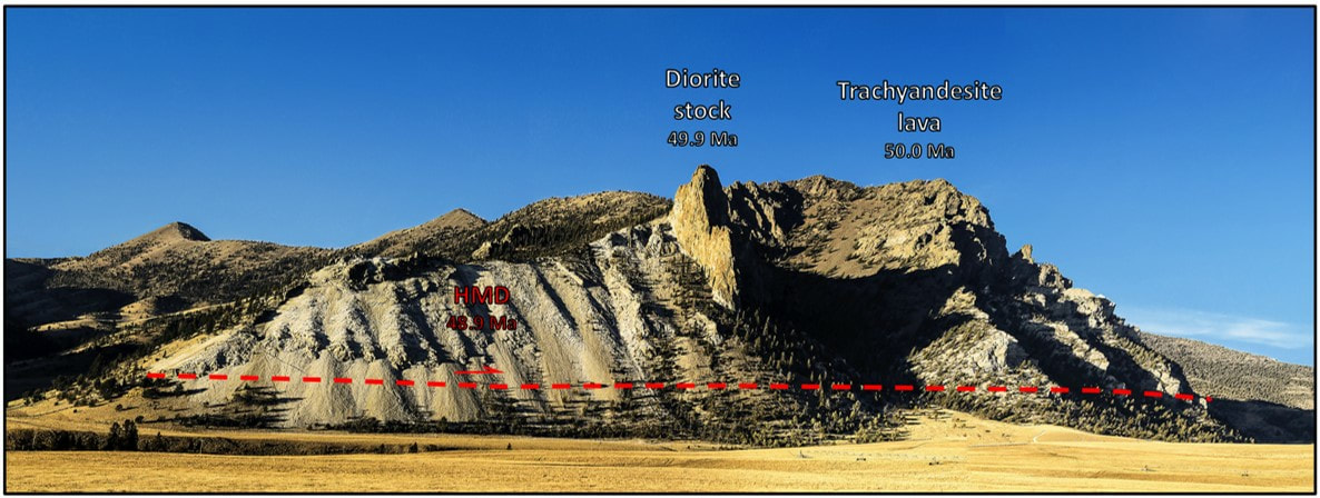
North view of White Mountain. Heart Mountain Detachment (HMD) shown by red dashed line. Diorite stock intruded about 48.9 million years ago (Ma) is to the right of the carbonate, temperature and pressure from that event caused the contact metamorphism of the Madison Formation to marble. Metamorphism occurred before movement of the HMD (48.9 Ma). The rock mass to the right of the diorite (east) is trachyandesite lava that was emplaced about 50 Ma.
Image: After Jones, G.L., 2018, Flickr; https://www.flickr.com/photos/wyojones/43736677870.
Image: After Jones, G.L., 2018, Flickr; https://www.flickr.com/photos/wyojones/43736677870.
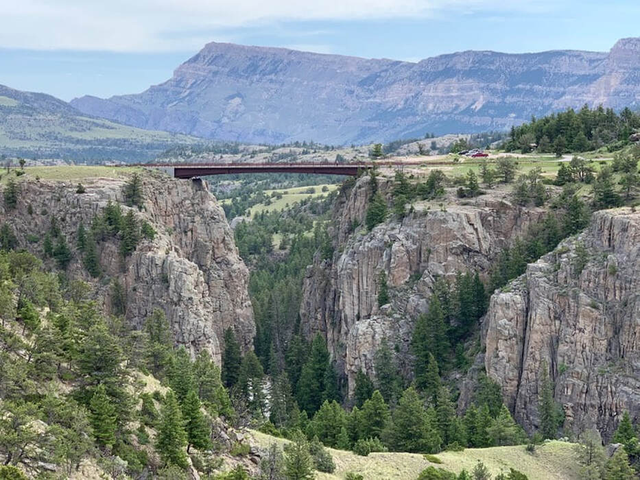
The view from the bridge on Wyoming Highway 296 (Chief Joseph Highway) over Sunlight Creek Gorge gives a spectacular view of the Archean basement rock of the Wyoming Craton. It is the highest bridge in Wyoming at 280 feet.
Sunlight Creek Bridge, Wyoming Highway 296. Note jointing in Precambrian rock. View is to the northeast toward Bald Ridge with Lower Paleozoic carbonate at the mouth of the Clarks Fork Canyon.
Image: Mark Fisher, 2019
Image: Mark Fisher, 2019
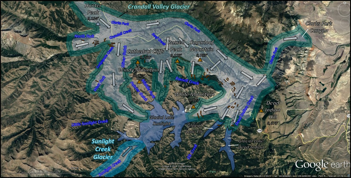
No basement granite rocks crop out in the valley of Sunlight Creek, yet Precambrian granite boulders are scattered across the floor near the eastern mouth of the basin. Glacial moraines in the western part of the valley contain no Precambrian clasts. This suggests at least two episodes of glaciation with different source terrane. The Crandall Lobe flowed off the Beartooth Precambrian granitic terrane down Crandall Creek, then up the valley of Sunlight Creek due to the restricted outlet through Clarks Fork Canyon. The ice provided a dam to form Glacial Lake Sunlight. This ice lobe provided the transportation of Precambrian clasts to the valley’s eastern moraines. The Sunlight glacier flowed eastward from the Absaroka range provided volcanic clasts to the western moraines. The ice put the final topographic touches to the spectacular landscape.
Pleistocene glaciation of Sunlight Basin area. Arrows show direction of ice movement. Ice dammed lakes shown in solid blue. Hunter Peak was covered by the Clarks Fork lobe of glacial ice. Brown mounds show the location of moraines.
Image: Google earth; Data: Carson, R.J., Cepeda, J.C., and Jaworowski, C., 1995, Glacial and Holocene geology of the Clarks Fork-Sunlight Creek region, Park County, Wyoming: Keck Geology Consortium, Plate 1, p. 42-43; https://keckgeology.org/files/pdf/symvol/9th/Wyoming/carson_et_al.pdf.
Image: Google earth; Data: Carson, R.J., Cepeda, J.C., and Jaworowski, C., 1995, Glacial and Holocene geology of the Clarks Fork-Sunlight Creek region, Park County, Wyoming: Keck Geology Consortium, Plate 1, p. 42-43; https://keckgeology.org/files/pdf/symvol/9th/Wyoming/carson_et_al.pdf.
The Sunlight Basin region is a place Native Americans passed through seeking freedom, trappers hunted its waterways for beaver fur, and miners sought their fortunes in mineral wealth in the mountains. It provides habitat for grizzly bear, elk, mule deer, moose, mountain goats, bighorn sheep, black bears, coyotes, mountain lions, wolves, Cutthroat and Brook trout, golden eagles and mountain bluebirds.
Geologic processes shaped beautiful vistas in Sunlight Basin, lifting blocks of ancient granitic rock thousands of feet and folding overlying Phanerozoic sedimentary rocks during the latest Cretaceous and early Tertiary Laramide Orogeny. A massive 8,900 square mile Eocene volcanic field ignited volcanic cones and covered the area with up to 5,000 thousand feet of igneous and volcaniclastic rocks. One or more of these volcanoes catastrophically collapsed, spreading mountain-sized clasts over many miles with the Heart Mountain Detachment. Streams carved canyons, eroding and transporting sediment eastward, then south to the Gulf of Mexico. Several thousand feet of glacial ice carved cirques, horns, moraines and glacial scratches on the rocks, during the Pleistocene. The result is a landscape of incomparable beauty.
Geologic processes shaped beautiful vistas in Sunlight Basin, lifting blocks of ancient granitic rock thousands of feet and folding overlying Phanerozoic sedimentary rocks during the latest Cretaceous and early Tertiary Laramide Orogeny. A massive 8,900 square mile Eocene volcanic field ignited volcanic cones and covered the area with up to 5,000 thousand feet of igneous and volcaniclastic rocks. One or more of these volcanoes catastrophically collapsed, spreading mountain-sized clasts over many miles with the Heart Mountain Detachment. Streams carved canyons, eroding and transporting sediment eastward, then south to the Gulf of Mexico. Several thousand feet of glacial ice carved cirques, horns, moraines and glacial scratches on the rocks, during the Pleistocene. The result is a landscape of incomparable beauty.
Sunlight Basin, Wyoming in springtime.
Image: Wyoming Cooperative Fish and Wildlife Research Unit | Absaroka Elk Ecology Project; http://wyocoopunit.org/projects/absaroka-elk-ecology-project.
Image: Wyoming Cooperative Fish and Wildlife Research Unit | Absaroka Elk Ecology Project; http://wyocoopunit.org/projects/absaroka-elk-ecology-project.
Things To Do in Sunlight Basin
Sunlight Basin is a gorgeous place with outstanding hikes, great fishing, ORV roads, horseback riding trails, hunting and camping. There are a couple of Forest Service campgrounds, one at Dead Indian and one at Little Sunlight. Undeveloped camping on the Forest Service is popular along the Sunlight Basin road. There are a number of ORV roads in Sunlight Basin with the Upper Sunlight Basin road open from July 16 to September 30. The Upper Sunlight Basin road requires fording Sunlight Creek near abandoned Lee City with your vehicle. This whole area is prime Grizzly Bear habitat. Carry bear spray and stay in groups. The following day hikes are our favorites: Dead Indian Creek to the Clarks Fork Canyon Overlook (Canyon Rim), High Bridge over Sunlight Creek to Clarks Fork Canyon Overlook, and Copper Lakes.
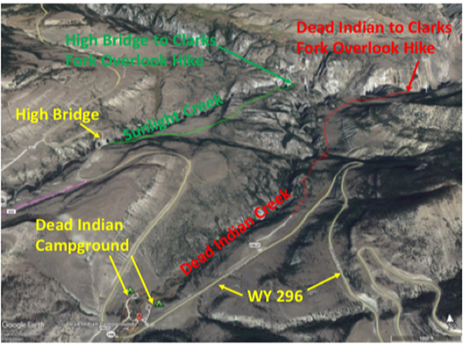
Aerial view to north of hikes to Clarks Fork Canyon overlooks.
Image by Google Earth
Image by Google Earth
Dead Indian Creek to Clarks Fork Canyon overlook hike (Canyon Rim Trail 761): Driving down into Sunlight Basin on the switchbacks from Dead Indian Hill on WY 296, turn right off the highway on a gravel road about one-half mile before the Dead Indian Campground. Drive on this unpaved road for about a quarter mile and park at the trailhead. Hike on mostly flat trail above and on east side of Dead Indian Creek for almost two miles until you reach the incredible views of the Clarks Fork Canyon and Sunlight Falls. Most of the hike is at The Great Unconformity between the Archean basement and the overlying Cambrian Flathead Sandstone. Be extremely careful of the cliffs and decide for yourself what is safe. Because of the cliffs, this is not a safe hike for children. Return the way you came.
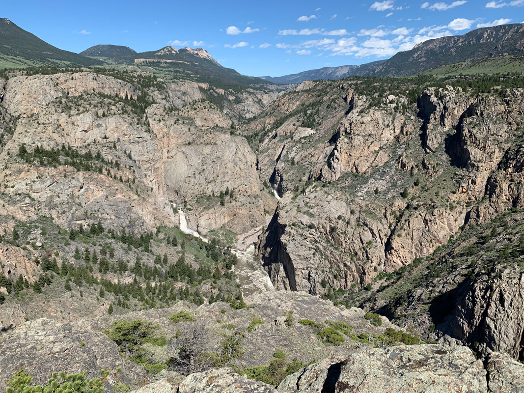
Clarks Fork River, Clarks Fork Canyon, and Sunlight Falls. View to northwest from hike on Dead Indian Creek to Clarks Fork Canyon overlook (Canyon Rim Trail 761).
Photo by Mark Fisher
Photo by Mark Fisher
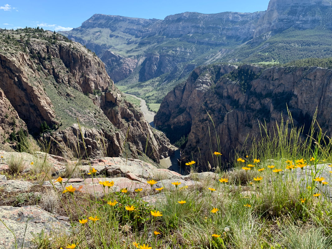
Clarks Fork River, Clarks Fork Canyon, and Bald Ridge. View to east from hike on Dead Indian Creek to Clarks Fork Canyon overlook (Canyon Rim Trail 761).
Photo by Mark Fisher
Photo by Mark Fisher
High Bridge over Sunlight Creek to Clarks Fork Canyon overlook hike: Driving down into Sunlight Basin on the switchbacks from Dead Indian Hill on WY 296, pass Dead Indian Campground, pass the Sunlight dirt road (101) on the left by 0.4 miles, pull in the parking lot on the right adjacent to the High Bridge over Sunlight Creek. The parking lot and most of the hike is at The Great Unconformity between the Archean basement and the overlying Cambrian Flathead Sandstone. There are multiple unmarked trails heading in different directions in this area. Pick a trail, or your own path, that heads to the northeast on the rolling to mostly flat area between Sunlight Creek and Dead Indian Creek. In about 1.5 miles, the area between the two creeks narrows to a ridge and you come to amazing views of the Clarks Fork Canyon, Sunlight Creek, and Dead Indian Creek. Be extremely careful of the cliffs and decide for yourself what is safe. Because of the cliffs, this is not a safe hike for children. Return the way you came. This should be a National Park!
View into Clarks Fork Canyon from ridge between Sunlight Creek and Dead Indian Creek.
Photo by Mark Fisher
Photo by Mark Fisher
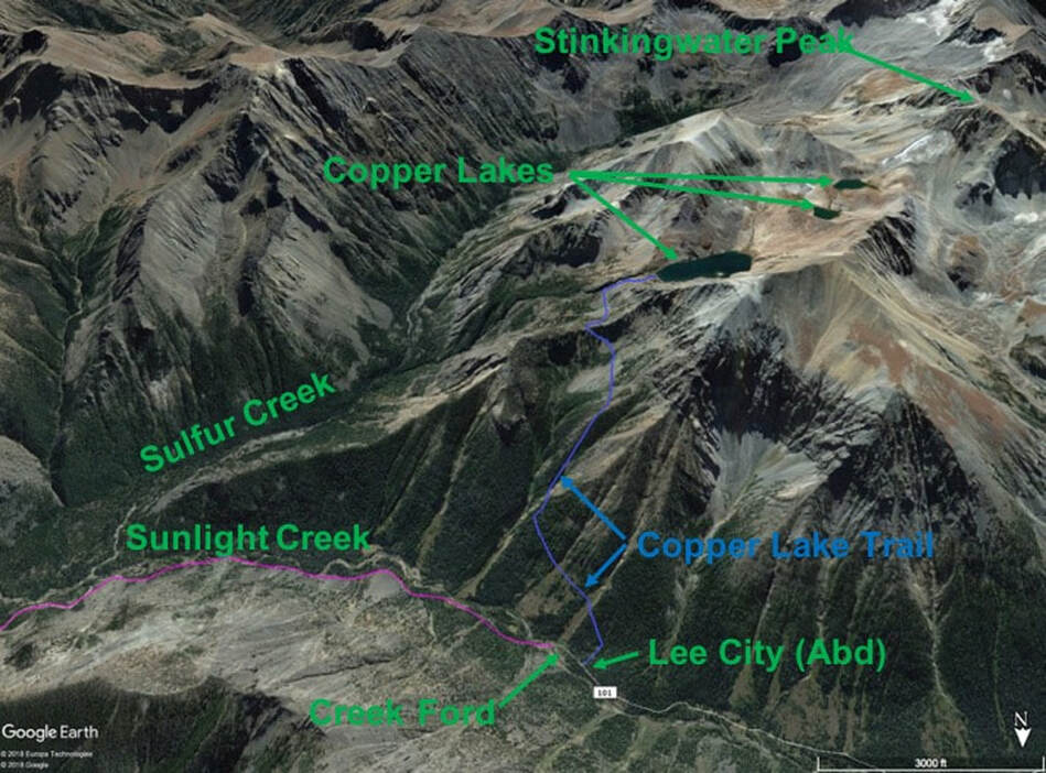
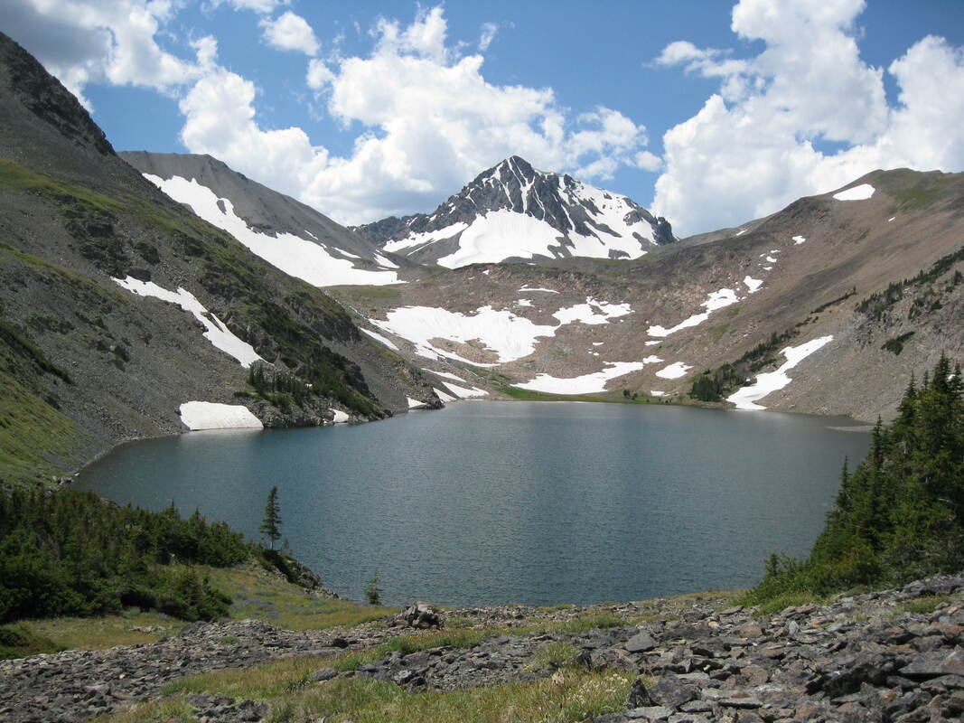
Copper Lakes hike: Driving down into Sunlight Basin on WY 296, pass Dead Indian Campground, turn left onto gravel Sunlight Road (101), and travel about twenty miles upstream along Sunlight Creek (high clearance 4WD recommended). You will pass the Sunlight Ranger Cabin on the left at about 8 miles, and Little Sunlight Campground on the right at about 10 miles. The last three miles of this drive is rougher and only open to vehicles from July 16 to September 30, but you can ride a mountain bike or hike the last part when it is closed. Just before reaching abandoned Lee City and Copper Lake trailhead, you reach a ford of Sunlight Creek. I rarely cross this ford with my vehicle because of high water. I park and wade across the creek. After crossing Sunlight Creek, walk 0.1 miles further up the road and turn left on a trail/two track that passes an abandoned mining cabin. The Copper Lake trail starts on the valley wall just past the ruined cabin. Initially, the trail climbs up the valley wall in a downstream direction. Copper Lakes trail is steep and climbs 2,400 vertical feet over 2.2 miles (4.4 miles roundtrip). It has a few sections that are very steep with loose volcanic rock and soil. Hiking sticks would be useful. You can extend the hike by working your way around the left side of the lake and hiking to the Upper Copper Lakes just below Stinkingwater Peak. If you are hardcore and want a longer adventure, you can make a long loop hike by climbing the ridge above the uppermost Copper Lake and returning down to Sunlight Creek on an old mining road in Sulphur Creek. The Copper Lakes area is in the Sunlight/Stinkingwater volcanic vent complex with numerous dikes radiating outward. In this area are veins filled with silver, copper and lead minerals that are associated with the intrusives (see pages 34 to 51 in USGS Bulletin 1447). AllTrails has additional descriptions and photos of the Copper Lake hike. Bring your bear spray. Enjoy the solitude and spectacular views!
South aerial view of hike to Copper Lakes and Stinkingwater Peak.
Image by Google Earth
Image by Google Earth
Copper Lake, Stinkingwater Peak and a small unnamed glacier below the peak (July 30).
Photo by Mark Fisher
Photo by Mark Fisher
View from just below Stinkingwater Peak down Sulphur Creek (October 10).
Photo by Mark Fisher
Photo by Mark Fisher

The material on this page is copyrighted
