Wow Factor (3 out of 5 stars):

Geologist Factor (2 out of 5 stars):

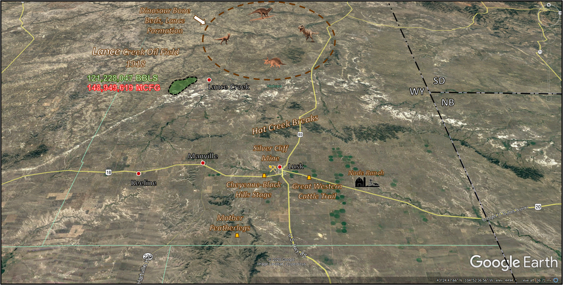
North aerial view of Lusk area, Eastern Wyoming.
Image: Google Earth
Image: Google Earth
Lusk Area History
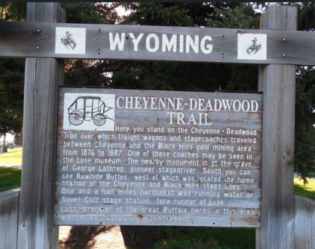
“Gold in the Black Hills” was the message carried by Charley Reynolds to Fort Laramie from the 1874 Custer Expedition. Gold fever ignited as the message got out when the dispatch rider reached Hat Creek Station (this 1875 military post and station are the first structures built by Euro-Americans between the Black Hills and Fort Laramie on Sioux land), about 13 miles north of future Lusk township. By 1876, the 300 mile Cheyenne to Black Hills Stage and Express Line was hauling supplies, gold, and gold-seekers across eastern Wyoming to and from the gold fields. Horse teams were changed about every hundred miles. Stage stations were established averaging about 10 to 15 miles apart along the route. Road agents maintained a steady income by robbing unguarded stages and passengers along the trail. The Stagecoach service ended in 1887 with the arrival of the Wyoming Central Railroad.
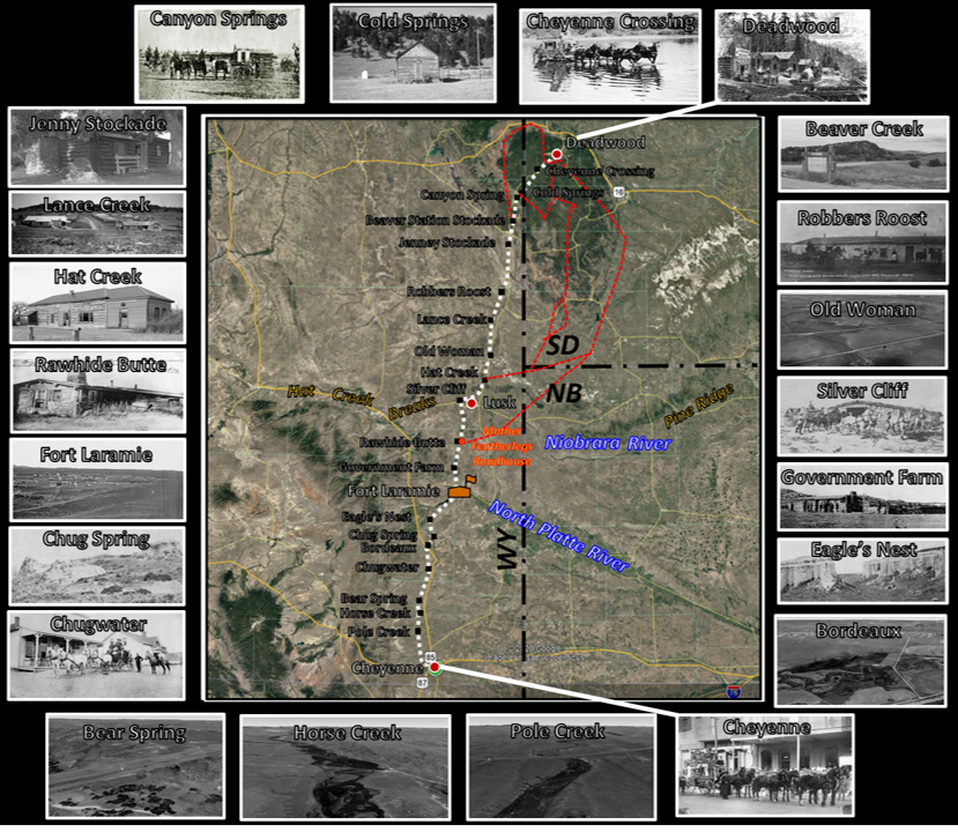
Cheyenne to Deadwood stage route. Main road (whited dotted line) and stations (black dots) and miscellaneous roads (red dashed line) are displayed.
Image: Base : Google Earth; Bear Springs, Horse Creek, Pole Creek, Old Woman: Google Earth Street view; Cheyenne, Chugwater, Fort Laramie, Hat Creek, lance Creek Jenny Stockade, Canyon Springs, Cheyenne Crossing, Deadwood, Robbers Roost, Silver Cliff: http://www.wyomingtalesandtrails.com; Chug Spring, Eagle’s Nest: Carley, M., 1965,Cheyenne-Deadwood Trail Trek (1964): Trek No. 15 of the Emigrant Trail Treks: Annals of Wyoming, Vol. 37, No.1, p. 92: https://archive.org/details/annalsofwyom37121965wyom/page/92/mode/2up; Rawhide Butte: https://npgallery.nps.gov/NRHP/GetAsset/NRHP/69000190_photos; Beaver Creek: https://www.hmdb.org/m.asp?m=4305.
Image: Base : Google Earth; Bear Springs, Horse Creek, Pole Creek, Old Woman: Google Earth Street view; Cheyenne, Chugwater, Fort Laramie, Hat Creek, lance Creek Jenny Stockade, Canyon Springs, Cheyenne Crossing, Deadwood, Robbers Roost, Silver Cliff: http://www.wyomingtalesandtrails.com; Chug Spring, Eagle’s Nest: Carley, M., 1965,Cheyenne-Deadwood Trail Trek (1964): Trek No. 15 of the Emigrant Trail Treks: Annals of Wyoming, Vol. 37, No.1, p. 92: https://archive.org/details/annalsofwyom37121965wyom/page/92/mode/2up; Rawhide Butte: https://npgallery.nps.gov/NRHP/GetAsset/NRHP/69000190_photos; Beaver Creek: https://www.hmdb.org/m.asp?m=4305.
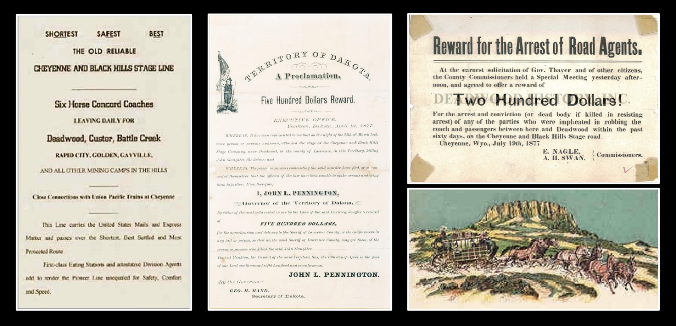
Notices for the Cheyenne-Black Hills Stage Line from 1877. Left: Advertisement for stagecoach promoting “First-class Eating … attentive Agents … Safety, Comfort, and Speed.” Center: Dakota Territory $500 reward poster for Murder and robbery of stage. Right Top: Wyoming Territory $200 reward poster for stagecoach robbery. Bottom Right: Stage passing Rawhide Butte in the background.
Image: Left: http://www.wyomingtalesandtrails.com/deadwood3.html;
Center: https://www.lofty.com/collections/prints/products/important-cheyenne-deadwood-stagecoach-robbery-reward-poster-1-1kggnn;
Top Right: https://deadwood.pastperfectonline.com/bysearchterm?keyword=Cheyenne-Deadwood+Stagecoach;
Bottom Right: http://userpages.aug.com/bdobson/deadwood.html
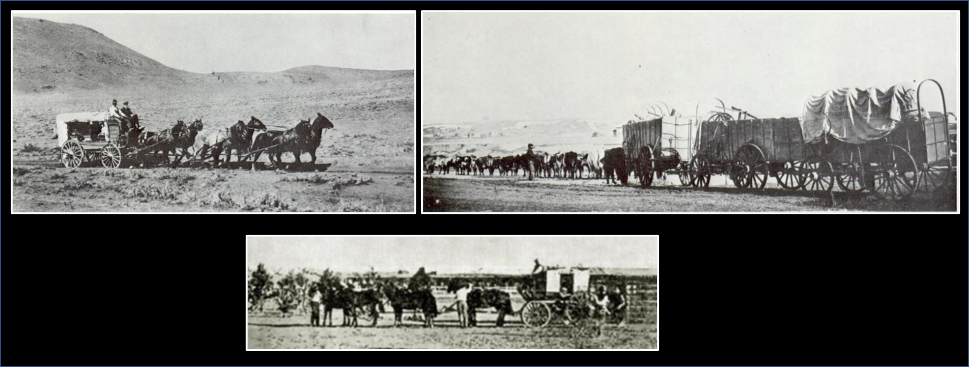
Cheyenne-Deadwood trail traffic: Left: Concord Coach; Right: Freight Trains, Bottom: Iron-clad Treasure Coach.
Image: Left & Right: Urbanek, M., 1985, in Worcester, D., Editor, The Western Writers of America, Pioneer Trails West, Fig. p. 242 & 244; Bottom: http://www.wyomingtalesandtrails.com/deadwood3.html.
Image: Left & Right: Urbanek, M., 1985, in Worcester, D., Editor, The Western Writers of America, Pioneer Trails West, Fig. p. 242 & 244; Bottom: http://www.wyomingtalesandtrails.com/deadwood3.html.
Cheyenne-Deadwood Stage Trail Marker located west of Lusk Wyoming on south side of U.S. Highway 20 at rest area.
Image: https://www.flickr.com/photos/auvet/21305647399.
Image: https://www.flickr.com/photos/auvet/21305647399.
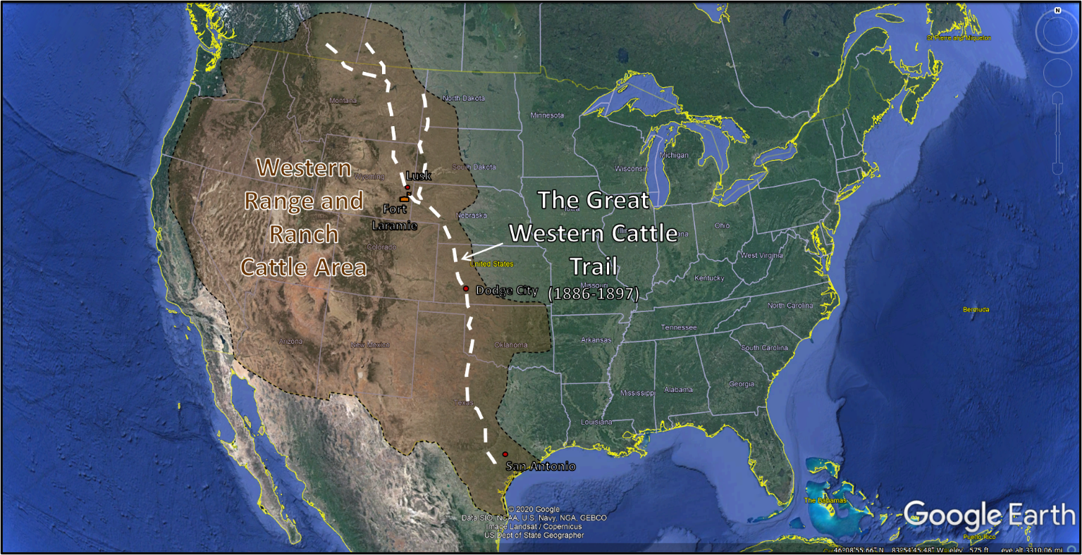
Lusk is located at the northern margin of the High Plains physiographic region of the Great Plains. Before the Black Hills gold discovery, the area had been Indian buffalo hunting ground. It was an established route to Fort Laramie through the Hat Creek military outpost. The herds fed upon the lush grass of the high plains. Frank S. Lusk established the Node Ranch in 1880 about 15 miles east of present-day Lusk. The operation was one of the first cattle ranches in the area. The Great Western Cattle Trail passed the future Lusk area, herding Texas Longhorns to the open range of the Wyoming, Dakota, and Montana Territories from 1876 to 1897. The Wyoming cattle industry boomed from 1868 to 1886.
The main route of the Great Western Cattle Trail, Texas to Canada.
Image: Google Earth; Data: https://homerrotary.org/stories/on-the-trail-of-history
Image: Google Earth; Data: https://homerrotary.org/stories/on-the-trail-of-history
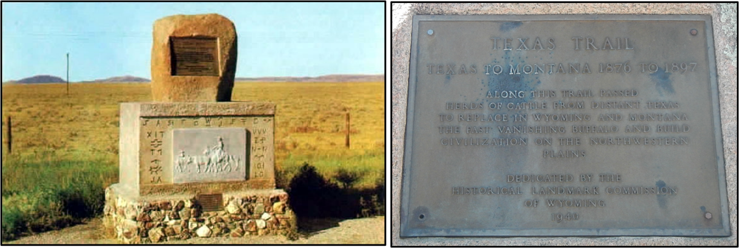
Great Western Trail Marker east of Lusk Wyoming south along U.S. Highway 20. Famous cattle brands of ranches that trailed cattle along the trail are depicted on marker.
Image: http://www.wyomingtalesandtrails.com/cattle4-2.html.
Image: http://www.wyomingtalesandtrails.com/cattle4-2.html.
Silver Cliff Mine, Founding of Lusk and Silver Cliff Hotel
The Silver Cliff Mine (section 7, Township 32 North, Range 63 West) was discovered in 1879 near the crest of Silver Cliff Hill. Gold-silver-copper ore occurs in fault gouge and in the highly-fractured footwall sandstone along the Cambrian-Precambrian unconformity of a North 25 degree East trending reverse fault. The fault extends about 2,800 feet and has a maximum of 70 feet vertical offset at the top of the Precambrian rock. Ore assay reports 0.5% silver (Au), <0.02 to 10.88% copper (Cu); and 0.16 to 15.04% gold (Ag) (https://www.mindat.org/loc-7310.html).

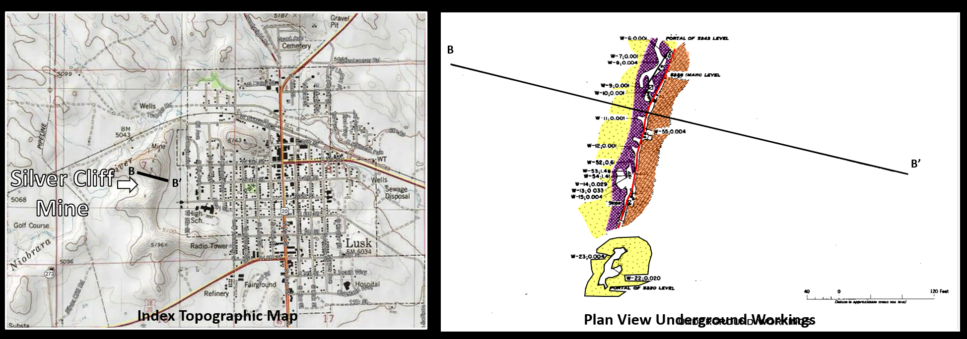
Silver Cliff Mine cross section BB’.
Image: After Wilmarth, V.R., and Johnson, D.H., 1954, Uranophane at Silver Cliff Mine, Lusk, Wyoming: U.S. Geological Survey, Bulletin 1009-A, scale 1:960; https://ngmdb.usgs.gov/Prodesc/proddesc_20529.htm.
Image: After Wilmarth, V.R., and Johnson, D.H., 1954, Uranophane at Silver Cliff Mine, Lusk, Wyoming: U.S. Geological Survey, Bulletin 1009-A, scale 1:960; https://ngmdb.usgs.gov/Prodesc/proddesc_20529.htm.
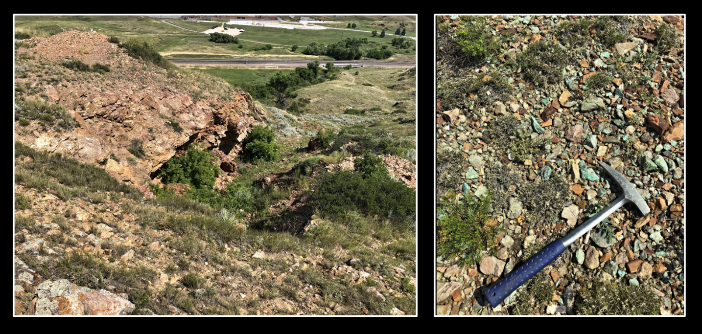
North view of Silver Cliff Hill mine (left) and mine dump (right).
Image: https://www.mindat.org/loc-7310.html.
Image: https://www.mindat.org/loc-7310.html.
The origin of Lusk began in the mining tent town of Silver Cliff a half-mile to the west. In 1886, the townsite’s land was needed for the approaching railroad construction. Frank Lusk donated land to the east for a new town and Silver Cliff was quickly abandoned. The railroad named the new town after Lusk, who also happened to be the lone resident stockholder in the Wyoming Central Railroad.

The mining operations ended in 1884 and remained closed for 34 years when a uranium deposit was found. The radioactive ore was mined for four years for radium research and again, after World War II, from 1951 to 1953. The Silver Cliff Hotel (1918-1980s) in Lusk offered radium water and baths to guests until they lost popularity after the death of Eben Byers an industrialist and golfer. The socialite died from radiation induced cancers in 1932. Ore samples yielded 0.001 to 3.39% uranium oxide (U3O8) (https://www.mindat.org/loc-7310.html). This was the first recognized uranium deposit in Wyoming.
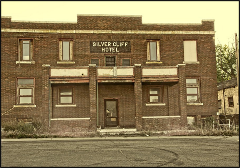
Silver Cliff Hotel in Lusk featured locally obtained “healthy” radium water and baths for guests.
Image: https://www.flickr.com/photos/dclmeyer/35976836786.
Image: https://www.flickr.com/photos/dclmeyer/35976836786.
Lusk is today the county seat for the least populous county, in the least populous state, in the nation. The original population was an assortment of miners, soldiers, prostitutes, shop keepers, road agents, cattle ranchers, cowboys, and railroad workers.
Sporting Establishments
Charlotte Shepard came to Lusk area in 1876 and opened a sporting establishment west of Rawhide Buttes adjacent to the stage road where gambling, whiskey, and prostitutes were served. The roadhouse madam was called “Mother Featherlegs” because of the appearance of her pantalettes in the Wyoming wind. She was murdered during a robbery by her associate "Dangerous Dick Davis the Terrapin" in 1879. A memorial marker stands at her grave about ten miles south of Lusk and five miles north of Rawhide Butte station. This is supposedly the only memorial marker to a prostitute in the United States. The monument reads:
“Here lies Mother Featherlegs. So called, as in her ruffled pantalettes she looked like a feather-legged chicken in a high wind. She was roadhouse ma'am. An outlaw confederate, she was murdered by "Dangerous Dick Davis the Terrapin" in 1879.”
“Here lies Mother Featherlegs. So called, as in her ruffled pantalettes she looked like a feather-legged chicken in a high wind. She was roadhouse ma'am. An outlaw confederate, she was murdered by "Dangerous Dick Davis the Terrapin" in 1879.”
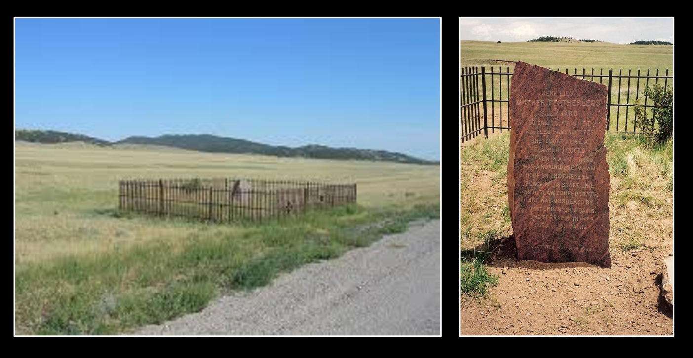
Mother Featherlegs graveyard (left), Rawhide Buttes in the distance, and granite headstone marker (right).
Image: http://www.motherfeatherlegs.com/the-1964-monument-dedication.html.
Image: http://www.motherfeatherlegs.com/the-1964-monument-dedication.html.
A more successful entrepreneur, Madam Dell Burk, ran a brothel on West Griffith Boulevard one block from the Main street of Lusk for 60 years (1919-1979). She was born Mary Ada Fisher in 1888. Dell arrived in Casper Wyoming in 1917 and operated in the Sandbar district until Wyoming passed the 18th Amendment and declared war on vice. She and her partner Bessie Housley moved to Lusk in 1919. Together they operated the Yellowstone Hotel bordello that was conveniently located across from the railroad station. At five PM every day Dell would ring a bell on the porch of her establishment to inform customers that the business hours had begun. Dell died in 1981 at the age of 93. Dell is remembered for her business acumen and philanthropy.
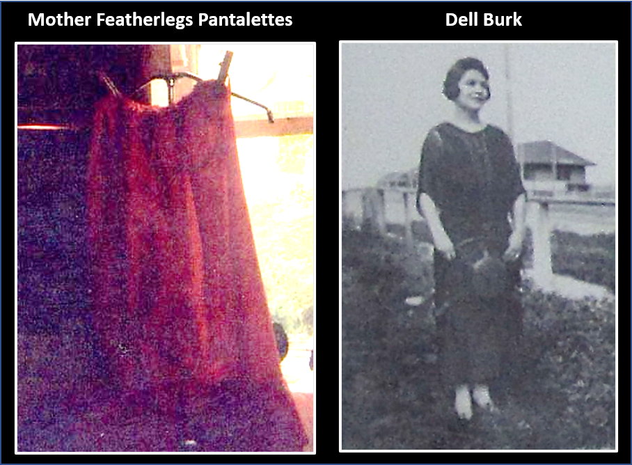
Left: Mother Featherlegs’ pantalettes, Lusk Stagecoach Museum; Right Dell Burke in 1920, with train depot in background.
Image: Left: http://www.wyomingtalesandtrails.com/deadwood2.html
Image: Left: http://www.wyomingtalesandtrails.com/deadwood2.html

Yellow Hotel across from the Lusk train depot (top) and a southwest looking photo from 1979 (center). The name comes from the yellow exterior painted stucco of the building. The building was intentionally burned down in 2012 (bottom).
Image: Top: Google Earth Street View; Center: https://www.pbs.org/video/dell-burke-and-the-yellow-hotel-jhusn6/; Bottom: https://www.townoflusk.org/?SEC=D35EEF2D-8BC1-4F62-B98F-9057EF942209.
Image: Top: Google Earth Street View; Center: https://www.pbs.org/video/dell-burke-and-the-yellow-hotel-jhusn6/; Bottom: https://www.townoflusk.org/?SEC=D35EEF2D-8BC1-4F62-B98F-9057EF942209.
Geology Of Lusk Area
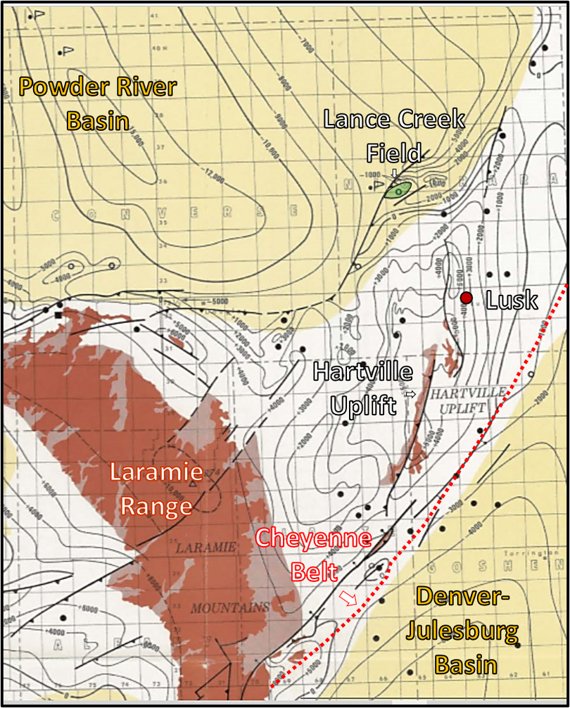
About two billion years before the present landscape developed, the Lusk area was near the Cheyenne Belt tectonic zone. This area was the tectonic suture between the Archean age Wyoming craton and the Proterozoic island arc and basins of the Central Plains Province (Yavapai). The northeast orientation of the Cheyenne Belt basement feature is repeated during the Laramide mountain building event (70 to 50 million years ago) that produced the Hartville Uplift, Lance Creek anticline and other structures in the region.
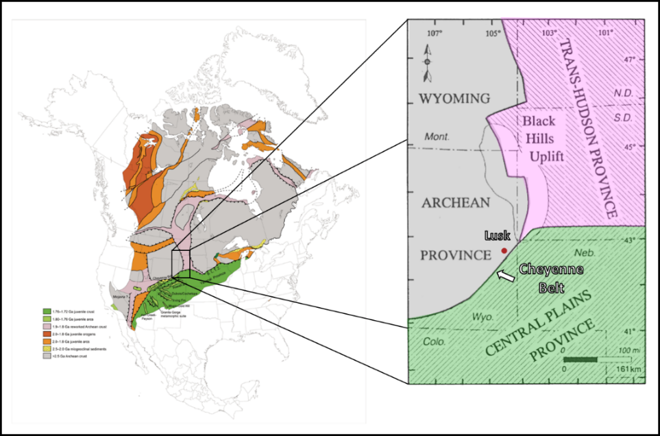
The Yavapai province is largely an assembly of oceanic arc terranes (ca. 1.76– 1.72 billion years ago) in a complex geometry that sutured along the Cheyenne belt (southern margin of Wyoming province).
Image: After: : Left: Whitmeyer, S.J. and Karlstrom, K.E., 2007, Tectonic model for the Proterozoic growth of North America: Geosphere v. 3, no. 4, Fig. 9, p. 232; https://pdfs.semanticscholar.org/085e/3fc258f879671b47b8f7c6054dc111ae7ca1.pdf?_ga=2.172873763.1676610084.1590456759-1393988075.1585461942; Right: Wicks, J.L., Dean, S.L., and Kulander, B.R., 2016, Regional tectonics and fracture patterns in the Fall River Formation (Lower Cretaceous) around the Black Hills foreland uplift, western South Dakota and northeastern Wyoming: Geological Society, London, Special Publications 169, Fig. 14, p. 158; http://citeseerx.ist.psu.edu/viewdoc/download?doi=10.1.1.819.7720&rep=rep1&type=pdf.
Image: After: : Left: Whitmeyer, S.J. and Karlstrom, K.E., 2007, Tectonic model for the Proterozoic growth of North America: Geosphere v. 3, no. 4, Fig. 9, p. 232; https://pdfs.semanticscholar.org/085e/3fc258f879671b47b8f7c6054dc111ae7ca1.pdf?_ga=2.172873763.1676610084.1590456759-1393988075.1585461942; Right: Wicks, J.L., Dean, S.L., and Kulander, B.R., 2016, Regional tectonics and fracture patterns in the Fall River Formation (Lower Cretaceous) around the Black Hills foreland uplift, western South Dakota and northeastern Wyoming: Geological Society, London, Special Publications 169, Fig. 14, p. 158; http://citeseerx.ist.psu.edu/viewdoc/download?doi=10.1.1.819.7720&rep=rep1&type=pdf.
Precambrian basement structure map of Cheyenne Belt in Lusk area, eastern Wyoming. Northeast structural orientations extend in a 25 to 40 mile wide zone from the Laramie Mountains to the Black Hills.
Image: Blackstone, D.L., Jr., 1993, Precambrian basement map of Wyoming—Outcrop and structural configuration: Geological Survey of Wyoming [Wyoming State Geological Survey] Map Series 43, scale 1:1,000,000; https://www.wsgs.wyo.gov/products/wsgs-1993-ms-43.pdf.
Image: Blackstone, D.L., Jr., 1993, Precambrian basement map of Wyoming—Outcrop and structural configuration: Geological Survey of Wyoming [Wyoming State Geological Survey] Map Series 43, scale 1:1,000,000; https://www.wsgs.wyo.gov/products/wsgs-1993-ms-43.pdf.
Lance Creek Oil Field
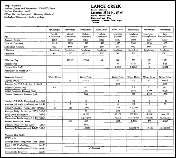
Lance Creek oil field was discovered in 1918. Ohio Oil Company (later Marathon Oil) opened 7 reservoirs in the field: Cretaceous Frontier, Muddy, Dakota and Lakota; Jurassic Morrison and Sundance; and Pennsylvanian Minnelusa. The asymmetric anticlinal axis trends North 45-75 degrees East. A reverse fault bounds the northwest flank of the trap which has an estimated 650 feet of structural closure.
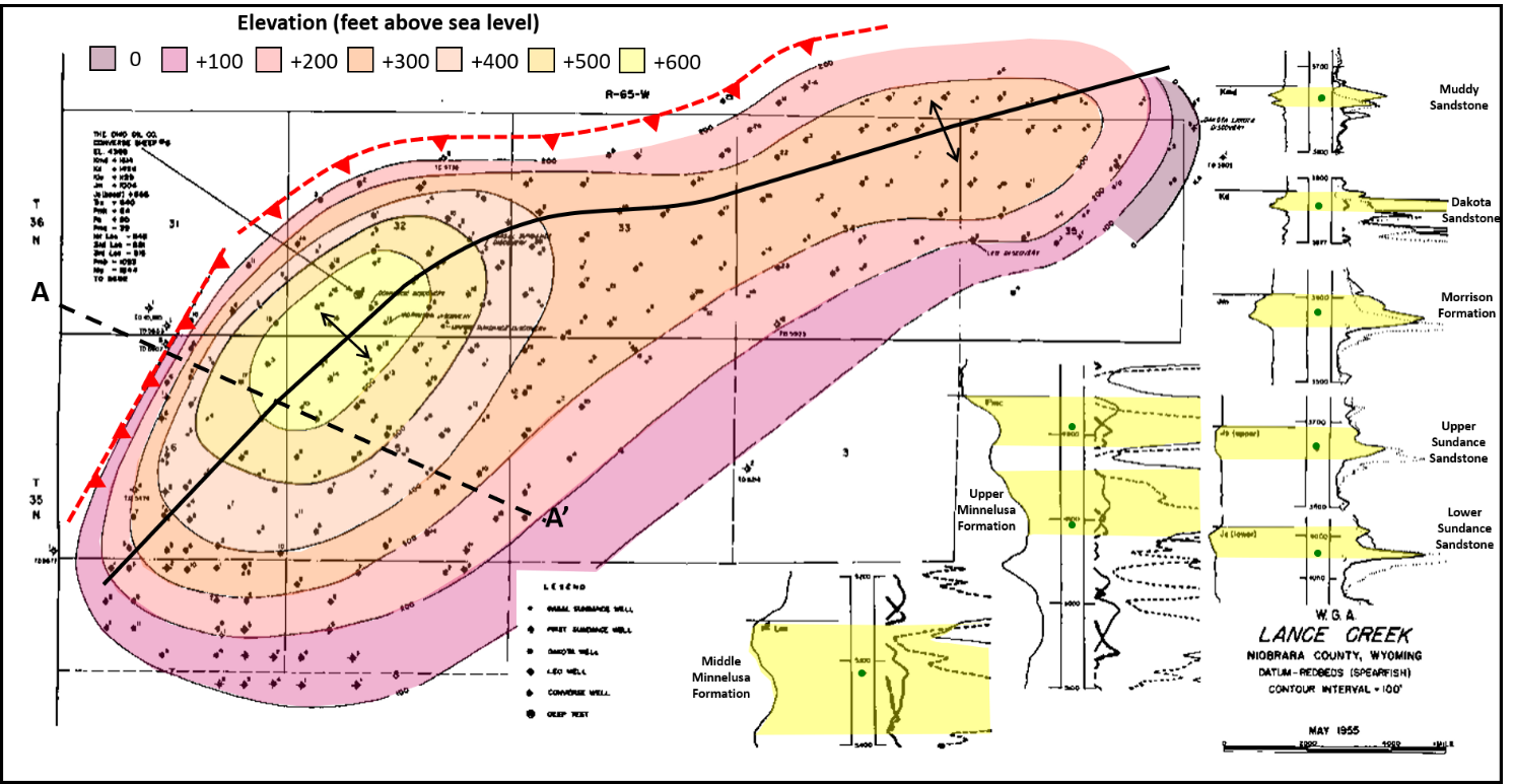
Generalized Triassic Red Beds (Spearfish Formation) structure map of Lance Creek Field and data sheet. Contour interval is 100 feet.
Image: After Van Sickle, D.M., Chairman Oil Field Symposium Committee,1961, Wyoming Geological Association, Wyoming Oil and Gas Fields Symposium (Includes 1961 Supplement), 1957, p. 255
Image: After Van Sickle, D.M., Chairman Oil Field Symposium Committee,1961, Wyoming Geological Association, Wyoming Oil and Gas Fields Symposium (Includes 1961 Supplement), 1957, p. 255
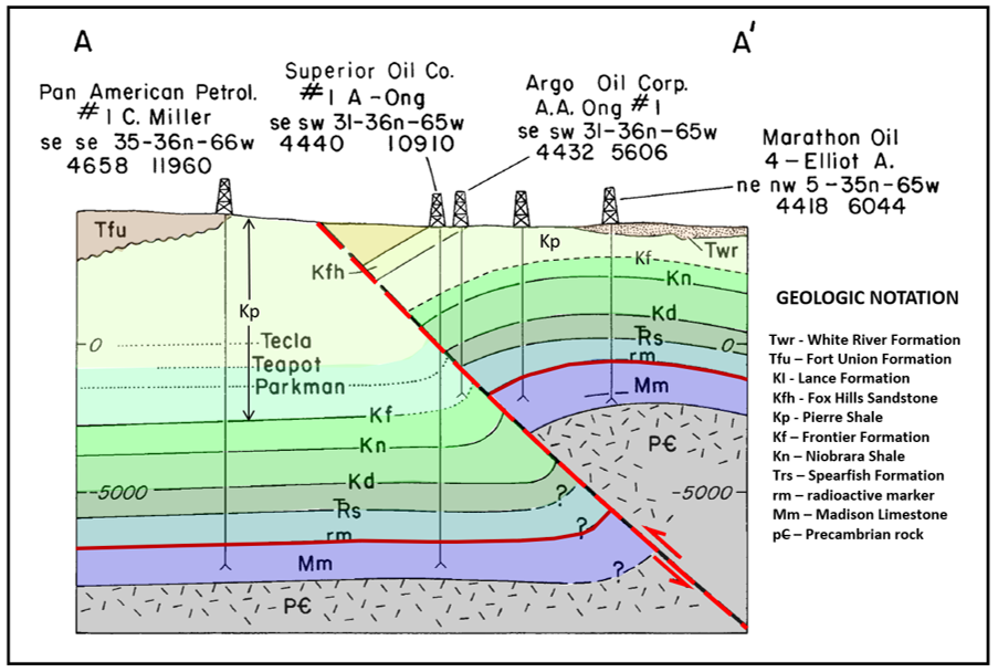
Cross section A- A' trending North 67 degrees W across Lance Creek field, Converse County, Wyoming. Cross section shows about 5,000 feet of vertical offset at the Precambrian level on the northwestern bounding reverse fault. The values below the well location represent the surface elevation (left) and the total depth (right).
Image: After Blackstone, D.L., Jr., 1988, Thrust Faulting: Southern Margin Powder River Basin, Wyoming: Wyoming Geologic Association 39t h Annual Field Conference Guidebook, Cross Section A-A’, Fig. 3, p. 37.
Image: After Blackstone, D.L., Jr., 1988, Thrust Faulting: Southern Margin Powder River Basin, Wyoming: Wyoming Geologic Association 39t h Annual Field Conference Guidebook, Cross Section A-A’, Fig. 3, p. 37.
The Pennsylvanian Minnelusa Formation is the most prolific oil reservoir at Lance Creek. In the mid-1950s, Lance Creek was the most productive of all Wyoming oil fields. Cumulative production is 121 million barrels of oil and 149 billion cubic feet of gas. The Pennsylvanian paleogeography of the Lusk area juxtaposes 315 million year old Ancestral Rocky Mountain uplifts with ancient basins in which seaway flooding (transgression) and withdrawals (regression) occurred. Pennsylvanian rocks have a complex architecture in southeastern Wyoming with sandstone, carbonate and evaporites deposited in multiple environments. Three informal Minnelusa Formation members are recognized at Lance Creek: upper (Converse), middle (Leo), and lower (Bell).
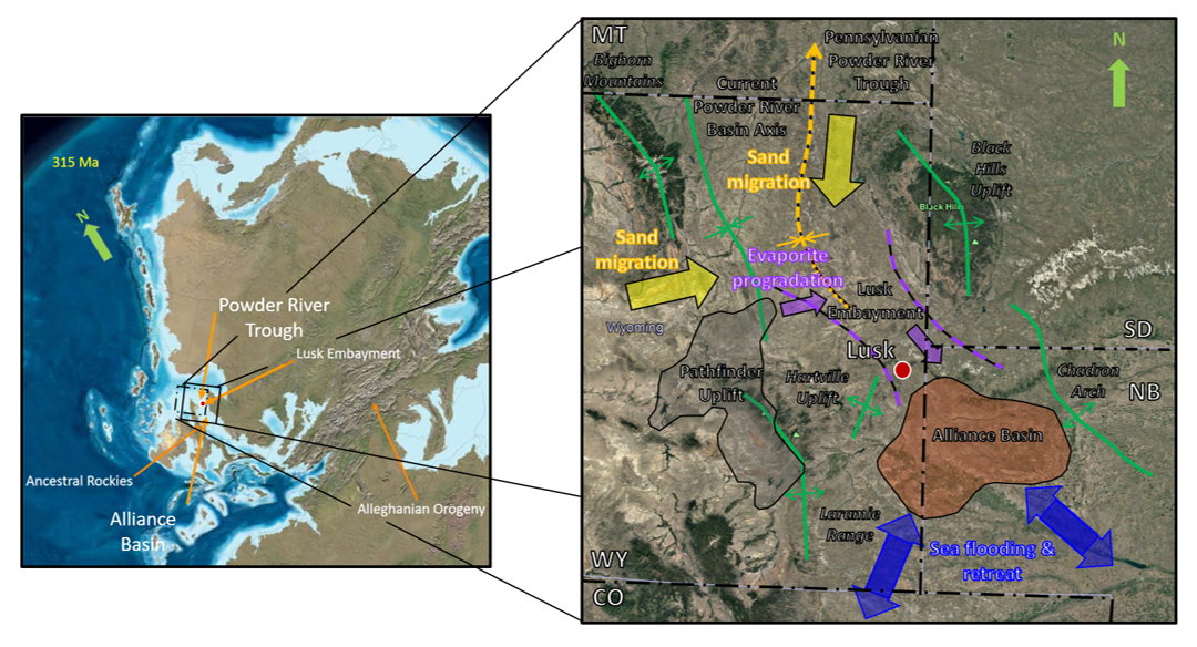
Paleogeography of North America and the Lusk area (red dot) 315 million years ago (left). Close up of Lusk area showing Pennsylvanian-age features on current surface image (right). The embayment (purple dashed line) was a northwest-southeast trending channel extending north from the Pennsylvanian-age Alliance basin (brown colored area) and the paleo-Powder River trough (gold dashed & dotted line). Pathfinder uplift (grey colored area) and much later Laramide structures are also displayed (green lines). The restricted seaway flooded (blue arrow) around Ancestral Rockies positive areas from the southwest and southeast. A sabkha (purple arrows)-costal dune (yellow arrows) complex prograde west and southwest during sea regression.
Image: Left: After Whitaker. S.T., 2018, Application of Sequence Stratigraphy in the Minnelusa Fm: A Method to Optimize Production: Wyoming Oil & Gas Fair/EORI Joint Conference: http://www.eoriwyoming.org/downloads/recent-event-presentations/Whitaker-Sequence-Strat-2018-web.pdf; Right: Google Earth.
Image: Left: After Whitaker. S.T., 2018, Application of Sequence Stratigraphy in the Minnelusa Fm: A Method to Optimize Production: Wyoming Oil & Gas Fair/EORI Joint Conference: http://www.eoriwyoming.org/downloads/recent-event-presentations/Whitaker-Sequence-Strat-2018-web.pdf; Right: Google Earth.

Stratigraphic diagram showing the distribution and relations of the Pennsylvanian rocks in southeastern Wyoming. Sandstone dominates the northwest, arkosic sandstone in the southwest area, evaporites are found in the restricted embayment in the northeast and carbonates are mainly developed in the seaway to the southeast.
Image: After Thomas, H.D., 1961, Geologic Structure and History of Wyoming: Wyoming Oil and Gas Fields Symposium (Includes 1961 Supplement), 1957, Fig. 7, p. 18.
Image: After Thomas, H.D., 1961, Geologic Structure and History of Wyoming: Wyoming Oil and Gas Fields Symposium (Includes 1961 Supplement), 1957, Fig. 7, p. 18.
Lusk Area Dinosaur Finds in Lance Formation
Lance Creek oil boom was over by the mid-1980s, but the area remained famous for dinosaur bones collected from the Cretaceous Lance Formation. Fossils include Triceratops, Edmontosaurus, and Pachycephalosaurus. A recent Tyrannosaurus rex was discovered north of Lusk and is on display at the Tate Museum in Casper.
Sixty-eight million years ago large ancient rivers drained the area into the Cannonball Sea to the east and north. The source of the Lance sediments deposited in the Lusk area were probably the clastic sedimentary rocks overlying the future Granite Mountains, Wind River and Owl Creek Ranges to the west. Paleocurrents and grain size distribution support this provenance.
Sixty-eight million years ago large ancient rivers drained the area into the Cannonball Sea to the east and north. The source of the Lance sediments deposited in the Lusk area were probably the clastic sedimentary rocks overlying the future Granite Mountains, Wind River and Owl Creek Ranges to the west. Paleocurrents and grain size distribution support this provenance.
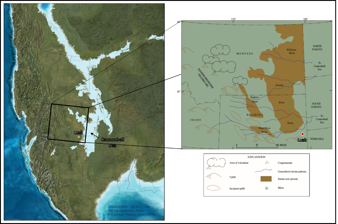
Latest Cretaceous paleogeography (68 million years ago) of North America and the Lance Formation.
Image: Left: After https://www.arcgis.com/apps/MapSeries/index.html?appid=987511ec2abd419f8a6e53e054b40bc5; Right: Connor, C.W., 1992, The Lance Formation Petrography and Stratigraphy, Powder River Basin and Nearby Basins, Wyoming and Montana: U.S. Geological Survey Bulletin 1917-I, Fig. 11, p. I14; https://pubs.usgs.gov/bul/1917i/report.pdf.
Image: Left: After https://www.arcgis.com/apps/MapSeries/index.html?appid=987511ec2abd419f8a6e53e054b40bc5; Right: Connor, C.W., 1992, The Lance Formation Petrography and Stratigraphy, Powder River Basin and Nearby Basins, Wyoming and Montana: U.S. Geological Survey Bulletin 1917-I, Fig. 11, p. I14; https://pubs.usgs.gov/bul/1917i/report.pdf.
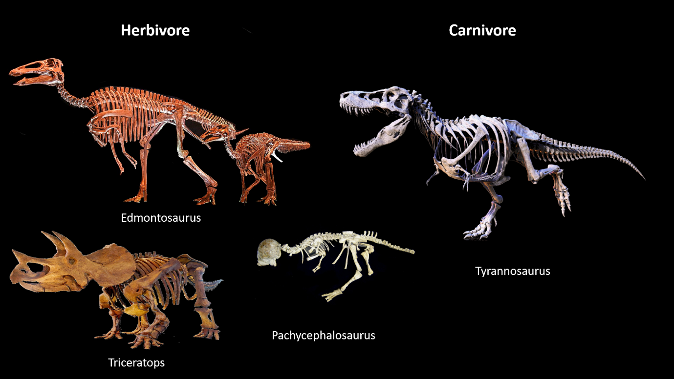
Dinosaurs of the Lance Formation in the Lusk area. Only five Tyrannosaurs have been discovered in Wyoming. The most recently found fossil is named Lee the T-rex.
Image: After Triceratops: https://commons.wikimedia.org/wiki/File:LA-Triceratops_mount-2.jpg, Edmontosaurus:https://www.wikiwand.com/en/Edmontosaurus_annectens, Pachycephalosaurs: https://paleonews.wordpress.com/tag/skin/,Tyrannosaurus: https://www.pinterest.com/pin/552535448032620637/.
Image: After Triceratops: https://commons.wikimedia.org/wiki/File:LA-Triceratops_mount-2.jpg, Edmontosaurus:https://www.wikiwand.com/en/Edmontosaurus_annectens, Pachycephalosaurs: https://paleonews.wordpress.com/tag/skin/,Tyrannosaurus: https://www.pinterest.com/pin/552535448032620637/.
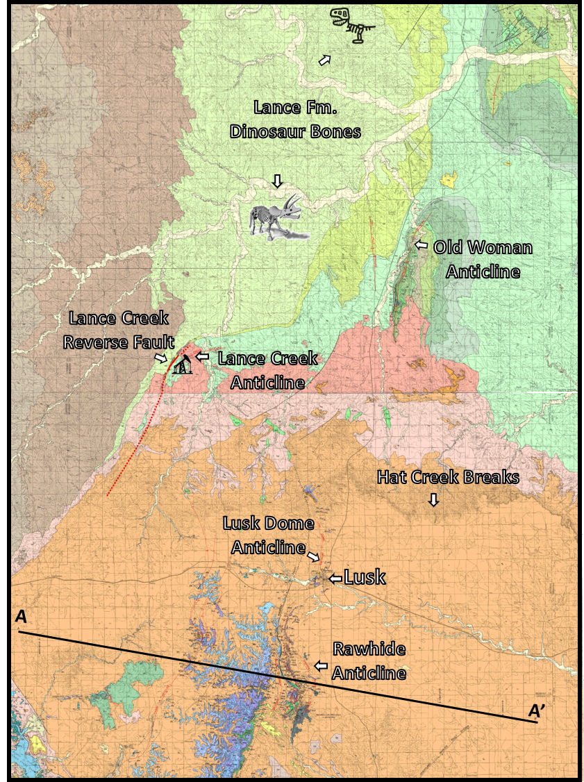


Lance Creek and Lusk area geology maps with description of map units and structural cross AA’.
Image: After Top: Johnson, J.F., and Micale, D.C., 2008, Geologic map of the Lance Creek 30' x 60' quadrangle, Niobrara and Converse counties, Wyoming, Fall River and Custer counties, South Dakota, and Sioux County, Nebraska: Wyoming State Geological Survey Map Series 79, scale 1:100,000; https://www.wsgs.wyo.gov/products/wsgs-2008-ms-79.pdf; Bottom: McLaughlin, J.F., Stafford, J.E., and Harris, R.E., 2011, Geologic map of the Lusk 30’ x 60’ quadrangle, Niobrara, Goshen, Converse, and Platte counties, Wyoming, and Sioux County, Nebraska: Wyoming State Geological Survey Map Series 82, scale 1:100,000; https://www.wsgs.wyo.gov/products/wsgs-2011-ms-82.pdf.
Image: After Top: Johnson, J.F., and Micale, D.C., 2008, Geologic map of the Lance Creek 30' x 60' quadrangle, Niobrara and Converse counties, Wyoming, Fall River and Custer counties, South Dakota, and Sioux County, Nebraska: Wyoming State Geological Survey Map Series 79, scale 1:100,000; https://www.wsgs.wyo.gov/products/wsgs-2008-ms-79.pdf; Bottom: McLaughlin, J.F., Stafford, J.E., and Harris, R.E., 2011, Geologic map of the Lusk 30’ x 60’ quadrangle, Niobrara, Goshen, Converse, and Platte counties, Wyoming, and Sioux County, Nebraska: Wyoming State Geological Survey Map Series 82, scale 1:100,000; https://www.wsgs.wyo.gov/products/wsgs-2011-ms-82.pdf.
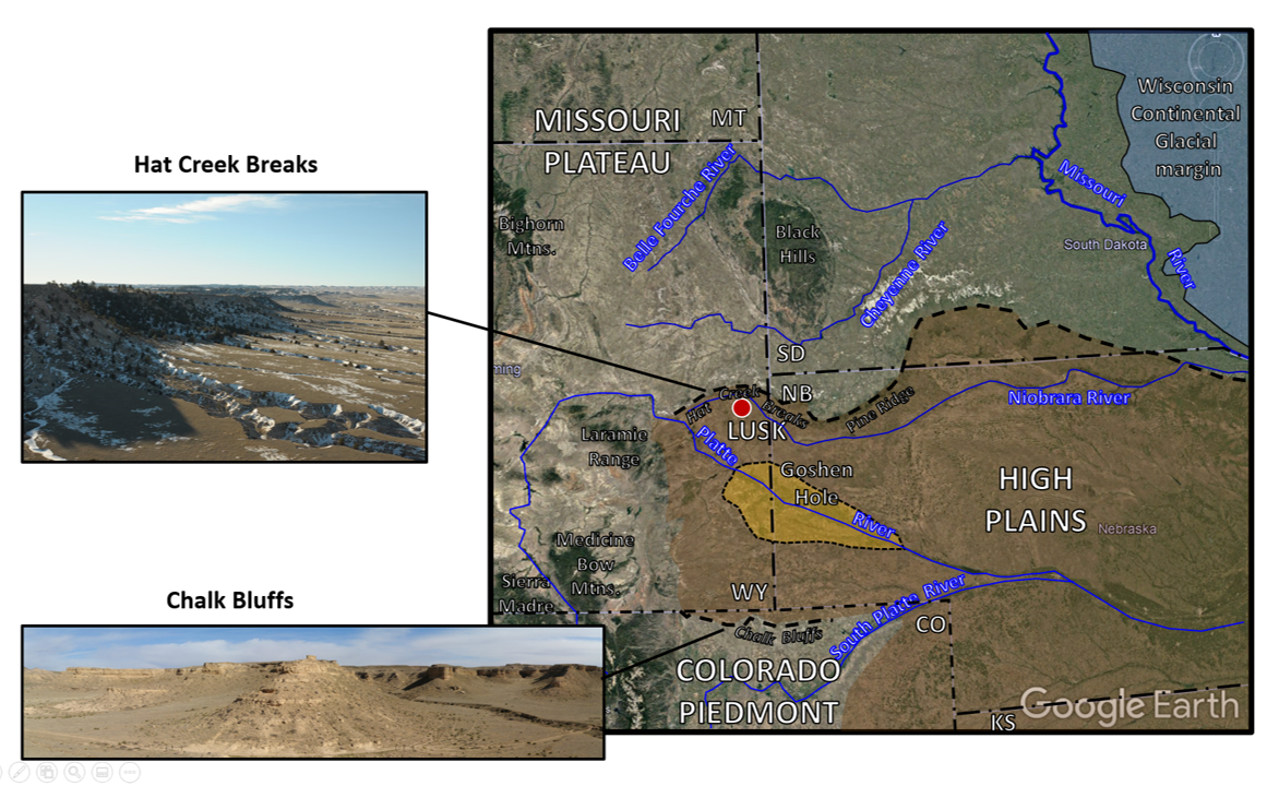
Wyoming High Plains Geology & Aquifer
Composed of Tertiary sedimentary rocks of Oligocene and Miocene age, the Wyoming High Plains is dominated by three formations on the surface. From oldest to youngest, these are the White River, Arikaree and the Ogallala Formations. Together they form the High Plains aquifer system in southeast Wyoming which is the main groundwater source in this area. Almost flat-lying, these formations slope gradually from the Laramie Mountains eastward to the Great Plains.
The northern margin of the Wyoming High Plains region is defined by Hat Creek Breaks-Pine Ridge, a continuous escarpment that rises 300 feet above the low land of the Missouri Plateau to the north. The Southern margin is formed by the Chalk Bluffs of northernmost Colorado. This 300-foot escarpment was carved by headward erosion by tributaries of the South Platte River.
The northern margin of the Wyoming High Plains region is defined by Hat Creek Breaks-Pine Ridge, a continuous escarpment that rises 300 feet above the low land of the Missouri Plateau to the north. The Southern margin is formed by the Chalk Bluffs of northernmost Colorado. This 300-foot escarpment was carved by headward erosion by tributaries of the South Platte River.
High Plains region of the Middle Rocky Mountain Province.
Image: Map: Google Earth; Hat Creek Break: https://mapio.net/pic/p-100854682; Chalk Bluffs: http://www.joeandfrede.com/colorado/chalk_bluffs/chalk_bluffs.htm?photo=5 .
Image: Map: Google Earth; Hat Creek Break: https://mapio.net/pic/p-100854682; Chalk Bluffs: http://www.joeandfrede.com/colorado/chalk_bluffs/chalk_bluffs.htm?photo=5 .

Wyoming High Plains geology map and potentiometric surface map of the High Plains aquifer system. A potentiometric map is a subsurface contour map showing the elevation of the top of the water table. Abbreviations on the map: Ogallala Formation To, Arikaree Formation Ta, White River Formation Two, Brule Formation Twrb, and Chadron Formation Twrc.
Image: Bartos, T.T., Diehl, S.F., Hallberg, L.L., and Webster,D.M., 2013, Geologic and Hydrogeologic Characteristics of the Ogallala Formation and White River Group, Belvoir Ranch near Cheyenne, Laramie County, Wyoming; in USGS Scientific Investigations Report 2013-5242, figure 5 on p 20; https://pubs.usgs.gov/sir/2013/5242/
Image: Bartos, T.T., Diehl, S.F., Hallberg, L.L., and Webster,D.M., 2013, Geologic and Hydrogeologic Characteristics of the Ogallala Formation and White River Group, Belvoir Ranch near Cheyenne, Laramie County, Wyoming; in USGS Scientific Investigations Report 2013-5242, figure 5 on p 20; https://pubs.usgs.gov/sir/2013/5242/
The Late Eocene to Early Oligocene White River Formation outcrops on the Wyoming High Plains or underlies younger Arikaree and Ogallala Formations. It is dominantly bentonitic mudstones that easily erodes. The bentonite comes from ash fall from volcanos to the southwest in Colorado, New Mexico, and Nevada. The depositional environment is an aggradational river system (ancestral North Platte) that deposited sediment over much of the Central Great Plains.
The Late Oligocene to Early Miocene Arikaree Formation are eolian and fluvial deposits in stream valleys. They consist of predominantly massive very fine to fine-grained sandstone with localized beds of volcanic ash. Arikaree sandstones armor the Hat Creek Breaks, creating the escarpment.
The Mid to Upper Miocene Ogallala Formation is the youngest formation on the Wyoming High Plains. It consists of weakly to firmly cemented conglomerate, sandstone, siltstone and mudstone deposited by streams in a complex sequence of cut and fills.
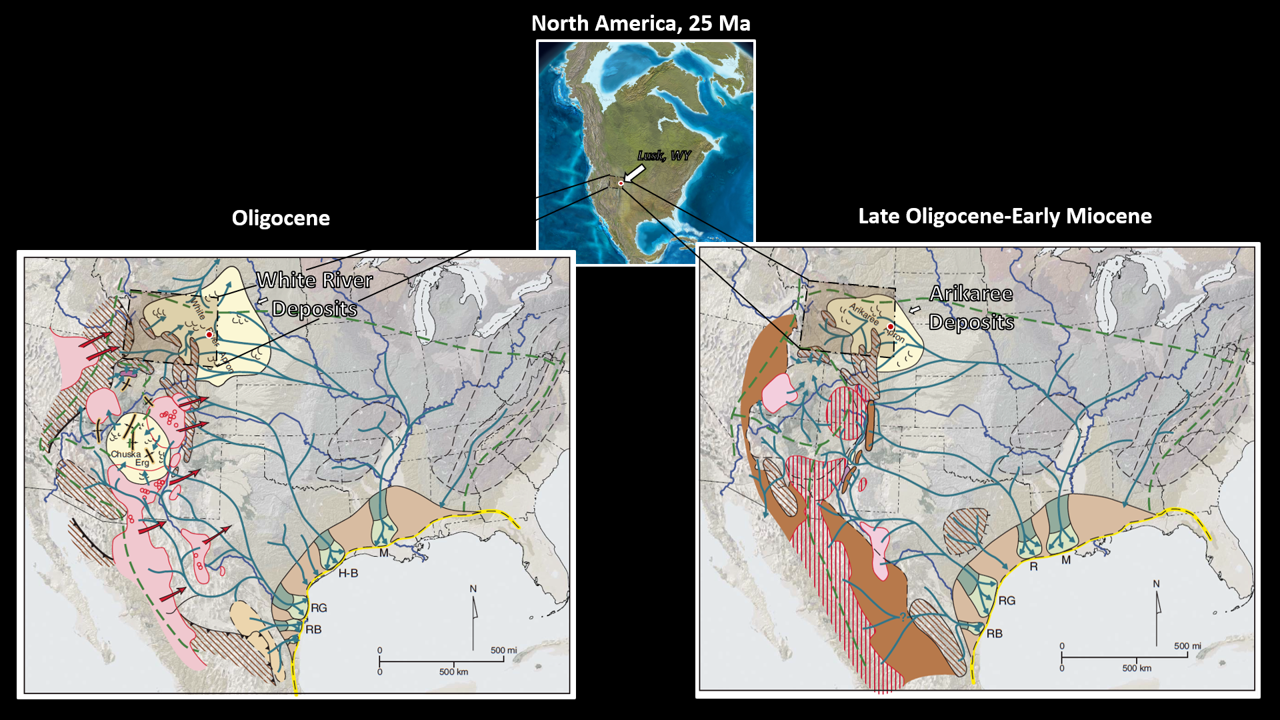
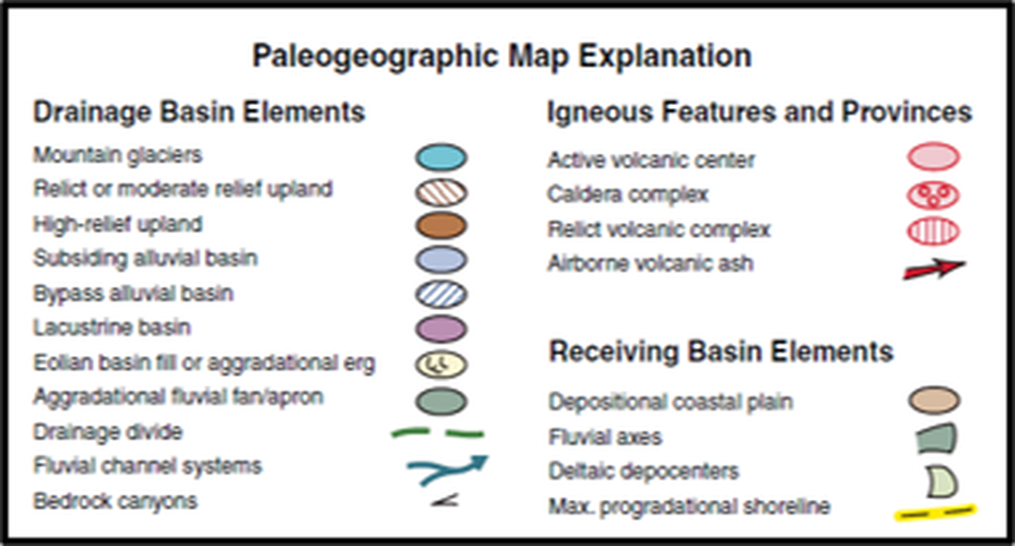
Paleogeography of North America in Oligocene to Early Miocene time. Wyoming (brown rectangle) and Lusk (red dot) are displayed.
Image: Top Center: After http://eas2.unl.edu/~tfrank/History%20on%20the%20Rocks/Nebraska%20Geology/Cenozoic/cenozoic%20web/2/Timescale.html#5;Bottom Left & Right: Galloway, W.E., Whitaker, T.L., and Ganey-Curry, P. 2011, History of Cenozoic North American drainage basin evolution, sediment yield, and accumulation in the Gulf of Mexico basin: Geosphere, Vol. 7, No. 4, Fig. 13, p. 957 & Fig. 14, p. 959; https://www.researchgate.net/publication/253354747_Cenozoic_North_American_Drainage_Basin_Evolution_Sediment_Yield_and_Accumulation_in_the_Gulf_of_Mexico_Basin/link/541061680cf2df04e75d580b/download.
Image: Top Center: After http://eas2.unl.edu/~tfrank/History%20on%20the%20Rocks/Nebraska%20Geology/Cenozoic/cenozoic%20web/2/Timescale.html#5;Bottom Left & Right: Galloway, W.E., Whitaker, T.L., and Ganey-Curry, P. 2011, History of Cenozoic North American drainage basin evolution, sediment yield, and accumulation in the Gulf of Mexico basin: Geosphere, Vol. 7, No. 4, Fig. 13, p. 957 & Fig. 14, p. 959; https://www.researchgate.net/publication/253354747_Cenozoic_North_American_Drainage_Basin_Evolution_Sediment_Yield_and_Accumulation_in_the_Gulf_of_Mexico_Basin/link/541061680cf2df04e75d580b/download.
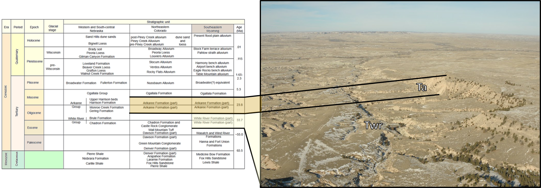
Left: Cenozoic stratatigraphic column for High Plains region; Right: Arikaree sandstone unit overlying White River mudstones at Hat Creek Breaks escarpment.
Image: Left: Condon, S.M., 2005, Geologic Studies of the Platte River, South-Central Nebraska and Adjacent Areas—Geologic Maps, Subsurface Study, and Geologic History: U.S. Geological Survey Professional Paper 1706, Fig. 4, p. 24; https://pubs.usgs.gov/pp/pp1706/pp1706.pdf; Right:
https://lh5.googleusercontent.com/p/AF1QipNnGHIG-5lN8SwnDNxZPNbImsOPlfkBqavsyxrv=h1440.
Things-To-Do
- Paleo Park
- Stagecoach Museum
- C & H Oil Refinery historical district complex
- Hat Creek Station & Fort
- Hat Creek Breaks
- Mother Featherlegs Cemetery
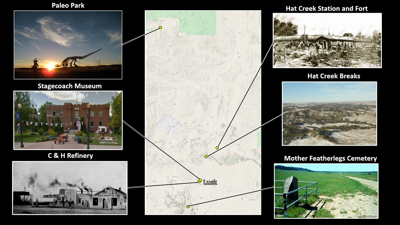
Paleo Park: http://www.paleopark.com/index.html
Stagecoach Museum: Google Map Street View
C & H Refinery: https://npgallery.nps.gov/NRHP/GetAsset/NRHP/00001672_photos
Hat Creek Station & Fort: http://www.wyomingtalesandtrails.com/deadwooda.html
Hat Creek Breaks: https://lh5.googleusercontent.com/p/AF1QipMAqKxl0uKF9qSGpUi2W3-LU9Ej6ih1fewH2zD9=h1440
Mother Featherlegs Cemetery: https://www.roadsideamerica.com/story/2260

The material on this page is copyrighted